Overview
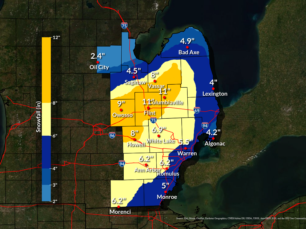
Parts of Southeast Michigan saw upwards of 11 inches of snow on Wednesday, February 2nd, 2022. This system started off as rain before changing over to all snow. Rain slowly changed over to snow during the early morning hours, however, the transition took a bit longer across portions of Metro Detroit. Some areas of Southeast Michigan only saw a 2-3 inches of snow, whereas portions of the Flint area has close to a foot of snow.
This system did not lack moisture. The 12Z Wed DTX sounding had a precipitable water value of 0.67 inches, quite high for early February and had a deep layer of saturation. With the extended outage of the KDTX radar, many radar composites today have given the impression that the returns were weakening as they entered Se Mi. That was not the case as the composites simply had no returns over much of Se Mi due to the radar outage.
There was a rather robust upper jet response today which triggered deep layer frontal ascent across the baroclinic zone across Se Mi. These types of systems can lead to a tremendous variability in snowfall amounts across a relatively short distance, which occurred in this event. The upper jet forcing was perhaps a little farther north than earlier model solutions suggested and the surface wave across the Ohio Valley was a bit stronger. This likely contributed to the better system relative isentropic ascent setting up farther north and west this morning. Once these elevated frontal circulations develop, they often become rather persistent. So the axis of heaviest snow set up from SW Lower Mi into the Lansing/Owosso/Flint/Saginaw/Caro regions and held through the entire day. This region was also colder and transitioned to snow earlier, so liquid snow ratios were higher. Larger flake size may have also contributed to this. Reports from this region are suggestive of snow totals in the 10 to 12 inch range, with some locally higher amounts certainly possible.
The stronger sfc reflection in the Ohio Valley also helped slow the sfc cold front across Se Mi. This kept the eastern portions of the area, from Adrian up through metro Detroit and Port Huron warmer today. The Tues evening DTX sounding suggested the warm layer was deeper and more pronounced than many model solutions suggested. This delayed the transition from rain to snow by several hours. Even when the rain did transition to snow, lingering boundary layer warmth contributed to a lot of melting/compaction through much of the day. Observations here at the NWS office in White Lake also suggested a lack of good dendrites through much of the event, which also contributed greatly to lower snowfall totals.
Snowfall Totals
For more detailed snow reports, please see the storm reports tab.
Radar
Radar imagery for KDTX is unavailable for this event, due to the radar undergoing extended maintenance for the Service Life Extension Program (SLEP).
The KDTX WSR-88D Doppler weather radar, operated by NOAA’s National Weather Service Detroit/Pontiac in White Lake, Michigan was down for a two-week period for an important upgrade. Technicians replaced the antenna pedestal, one of the most critical components of the radar, which is necessary for antenna rotation and positioning to capture data in all directions. The components are extremely heavy and required the radome be removed by crane. Both the pedestal and dome have been removed and replaced sucessfully.
The radar and pedestal were designed to last 25 years, and this radar has exceeded its life-span. This activity is necessary to keep the radar functioning for another 20 years or more.
The pedestal refurbishment is the third major project of the NEXRAD Service Life Extension Program, a series of upgrades that will keep our nation’s radars viable into the 2030s. NOAA’s National Weather Service, the United States Air Force, and the Federal Aviation Administration are investing $135 million in the eight year program. The first project was the installation of the new signal processor and the second project was the refurbishment of the transmitter. The fourth project will be the refurbishment of the equipment shelters. The Service Life Extension Program will be complete in 2023.
The KDTX WSR-88D is part of a network of 159 operational radars. The Radar Operations Center in Norman, Oklahoma, provides lifecycle management and support for all WSR-88Ds.
The National Weather Service Detroit/Pontiac in White Lake, MI can be found on social media at https://www.facebook.com/NWSDetroit and at https://twitter.com/NWSDetroit
Storm Reports
Below are preliminary storm total snowfall reports from the event.
PRELIMINARY LOCAL STORM REPORT...SUMMARY
NATIONAL WEATHER SERVICE DETROIT/PONTIAC MI
922 AM EST THU FEB 3 2022

..TIME...   ...EVENT...      ...CITY LOCATION...     ...LAT.LON...
..DATE...   ....MAG....      ..COUNTY LOCATION..ST.. ...SOURCE....
            ..REMARKS..

0950 PM     SNOW             ST. CLAIR SHORES        42.49N 82.89W
02/02/2022  M4.0 INCH        MACOMB             MI   TRAINED SPOTTER

            12 HOUR TOTAL.

0950 PM     SNOW             GRAND BLANC             42.93N 83.62W
02/02/2022  M9.0 INCH        GENESEE            MI   BROADCAST MEDIA

            14 HOUR TOTAL.

1030 PM     SNOW             HIGHLAND                42.64N 83.62W
02/02/2022  M6.8 INCH        OAKLAND            MI   NWS EMPLOYEE

            15 HOUR TOTAL SNOWFALL.

1115 PM     HEAVY SNOW       2 SSE BIRCH RUN         43.22N 83.77W
02/02/2022  M11.2 INCH       SAGINAW            MI   TRAINED SPOTTER

            17 HOUR TOTAL SNOWFALL.

1135 PM     SNOW             MANCHESTER              42.15N 84.04W
02/02/2022  M4.8 INCH        WASHTENAW          MI   TRAINED SPOTTER

            17 HOUR TOTAL SNOWFALL.

1150 PM     HEAVY SNOW       FLINT                   43.02N 83.69W
02/02/2022  M11.0 INCH       GENESEE            MI   OFFICIAL NWS OBS

            17 HOUR TOTAL SNOWFALL AT FLINT BISHOP AIRPORT.

1155 PM     SNOW             BRIDGEPORT              43.38N 83.88W
02/02/2022  M8.3 INCH        SAGINAW            MI   TRAINED SPOTTER

            17 HOUR TOTAL SNOWFALL.

1155 PM     SNOW             8 NW SAGINAW            43.50N 84.06W
02/02/2022  M4.5 INCH        SAGINAW            MI   CO-OP OBSERVER

            12 HOUR TOTAL SNOWFALL AT TRI CITIES AIRPORT.

1155 PM     SNOW             WYANDOTTE               42.21N 83.16W
02/02/2022  M6.0 INCH        WAYNE              MI   TRAINED SPOTTER

            15 HOUR TOTAL SNOWFALL.

1155 PM     SNOW             ROMULUS                 42.22N 83.37W
02/02/2022  M6.2 INCH        WAYNE              MI   OFFICIAL NWS OBS

            15 HOUR TOTAL SNOWFALL AT DETROIT METRO AIRPORT.

1200 AM     SNOW             MOUNT CLEMENS           42.60N 82.88W
02/03/2022  M6.0 INCH        MACOMB             MI   CO-OP OBSERVER

            24 HOUR SNOWFALL TOTAL.

1200 AM     SNOW             MIDLAND                 43.62N 84.23W
02/03/2022  M3.0 INCH        MIDLAND            MI   CO-OP OBSERVER

            24 HOUR SNOWFALL TOTAL.

1200 AM     SNOW             2 NW COLUMBIAVILLE      43.18N 83.44W
02/03/2022  M11.0 INCH       LAPEER             MI   TRAINED SPOTTER

            17 HOUR SNOWFALL TOTAL.

1213 AM     SNOW             LAPEER                  43.05N 83.32W
02/03/2022  M9.0 INCH        LAPEER             MI   PUBLIC

            STORM TOTAL

0100 AM     SNOW             4 SE OTISVILLE          43.12N 83.47W
02/03/2022  M9.3 INCH        GENESEE            MI   TRAINED SPOTTER

            18 HOUR SNOWFALL TOTAL.

0100 AM     SNOW             SHELBY TOWNSHIP         42.67N 83.03W
02/03/2022  M6.2 INCH        MACOMB             MI   TRAINED SPOTTER

            15 HOUR TOTAL SNOWFALL.

0100 AM     SNOW             4 E WHITE LAKE          42.65N 83.43W
02/03/2022  M6.9 INCH        OAKLAND            MI   OFFICIAL NWS OBS

            18 HOUR SNOWFALL TOTAL AT THE NWS WHITE LAKE OFFICE.

0100 AM     SNOW             EASTPOINTE              42.47N 82.96W
02/03/2022  M4.5 INCH        MACOMB             MI   TRAINED SPOTTER

            15 HOUR TOTAL SNOWFALL.

0200 AM     SNOW             GARDEN CITY             42.33N 83.33W
02/03/2022  M5.8 INCH        WAYNE              MI   TRAINED SPOTTER

            18 HOUR SNOWFALL TOTAL.

0430 AM     SNOW             YPSILANTI               42.24N 83.62W
02/03/2022  M5.7 INCH        WASHTENAW          MI   PUBLIC

            STORM TOTAL

0430 AM     SNOW             YPSILANTI               42.24N 83.62W
02/03/2022  M6.1 INCH        WASHTENAW          MI   TRAINED SPOTTER

            15 HOUR SNOWFALL TOTAL.

0544 AM     SNOW             3 SE OIL CITY           43.58N 84.55W
02/03/2022  M2.5 INCH        MIDLAND            MI   CO-OP OBSERVER

            STORM TOTAL

0544 AM     SNOW             2 SW MIDLAND            43.60N 84.26W
02/03/2022  M3.5 INCH        MIDLAND            MI   CO-OP OBSERVER

            STORM TOTAL

0550 AM     SNOW             4 W WEST BLOOMFIELD     42.57N 83.46W
02/03/2022  M5.2 INCH        OAKLAND            MI   NWS EMPLOYEE

            24 HOUR SNOWFALL TOTAL.

0630 AM     SNOW             CHESANING               43.18N 84.12W
02/03/2022  M8.0 INCH        SAGINAW            MI   CO-OP OBSERVER

            24 HOUR SNOWFALL TOTAL.

0630 AM     SNOW             5 NNW FILION            43.96N 83.04W
02/03/2022  M3.8 INCH        HURON              MI   CO-OP OBSERVER

            24 HOUR SNOWFALL TOTAL.

0630 AM     SNOW             AUBURN                  43.60N 84.08W
02/03/2022  M3.5 INCH        BAY                MI   CO-OP OBSERVER

            24 HOUR SNOWFALL TOTAL.

0630 AM     SNOW             CASS CITY               43.60N 83.18W
02/03/2022  M8.4 INCH        TUSCOLA            MI   CO-OP OBSERVER

            24 HOUR SNOWFALL TOTAL.

0700 AM     SNOW             VASSAR                  43.37N 83.58W
02/03/2022  M8.0 INCH        TUSCOLA            MI   CO-OP OBSERVER

            24 HOUR SNOWFALL TOTAL.

0700 AM     SNOW             ANN ARBOR               42.28N 83.73W
02/03/2022  M6.2 INCH        WASHTENAW          MI   CO-OP OBSERVER

            24 HOUR SNOWFALL TOTAL.

0700 AM     SNOW             OWOSSO                  43.00N 84.18W
02/03/2022  M9.0 INCH        SHIAWASSEE         MI   CO-OP OBSERVER

            24 HOUR SNOWFALL TOTAL.

0700 AM     SNOW             BURTON                  43.00N 83.62W
02/03/2022  M9.0 INCH        GENESEE            MI   CO-OP OBSERVER

            24 HOUR SNOWFALL TOTAL.

0700 AM     SNOW             3 N CANTON              42.35N 83.48W
02/03/2022  M4.1 INCH        WAYNE              MI   COCORAHS

            24 HOUR SNWOFALL TOTAL.

0700 AM     SNOW             2 S ORTONVILLE          42.82N 83.44W
02/03/2022  E6.1 INCH        OAKLAND            MI   COCORAHS

            24 HOUR SNOWFALL TOTAL.

0700 AM     SNOW             3 S BLOOMFIELD HILLS    42.54N 83.25W
02/03/2022  M4.0 INCH        OAKLAND            MI   COCORAHS

            24 HOUR SNOWFALL TOTAL.

0700 AM     SNOW             3 N CANTON              42.35N 83.48W
02/03/2022  M4.1 INCH        WAYNE              MI   COCORAHS

            24 HOUR SNOWFALL TOTAL.

0700 AM     SNOW             WATERFORD               42.66N 83.39W
02/03/2022  M6.0 INCH        OAKLAND            MI   COCORAHS

            24 HOUR SNOWFALL TOTAL.

0700 AM     SNOW             2 S ORTONVILLE          42.82N 83.44W
02/03/2022  M6.1 INCH        OAKLAND            MI   COCORAHS

            24 HOUR SNOWFALL TOTAL.

0730 AM     SNOW             6 NW MONROE             41.98N 83.47W
02/03/2022  M5.0 INCH        MONROE             MI   COCORAHS

            24 HOUR SNOWFALL TOTAL.

0730 AM     SNOW             1 NE HOWELL             42.62N 83.92W
02/03/2022  M8.0 INCH        LIVINGSTON         MI   NWS EMPLOYEE

            24 HOUR SNOWFALL TOTAL.

0730 AM     SNOW             OIL CITY                43.61N 84.59W
02/03/2022  M2.4 INCH        MIDLAND            MI   CO-OP OBSERVER

            24 HOUR SNOWFALL TOTAL.

0730 AM     SNOW             BAD AXE                 43.80N 83.00W
02/03/2022  M4.9 INCH        HURON              MI   CO-OP OBSERVER

            24 HOUR SNOWFALL TOTAL.

0730 AM     SNOW             FARMINGTON              42.46N 83.38W
02/03/2022  M4.3 INCH        OAKLAND            MI   CO-OP OBSERVER

            24 HOUR SNOWFALL TOTAL.

0730 AM     SNOW             MORENCI                 41.72N 84.22W
02/03/2022  M6.2 INCH        LENAWEE            MI   CO-OP OBSERVER

            24 HOUR SNOWFALL TOTAL.

0745 AM     SNOW             LEXINGTON               43.27N 82.53W
02/03/2022  M4.0 INCH        SANILAC            MI   CO-OP OBSERVER

            24 HOUR SNOWFALL TOTAL.

0800 AM     SNOW             1 S CLARKSTON           42.72N 83.42W
02/03/2022  M6.2 INCH        OAKLAND            MI   NWS EMPLOYEE

            16 HOUR SNOWFALL TOTAL.

0800 AM     SNOW             ALGONAC                 42.62N 82.53W
02/03/2022  M4.2 INCH        ST. CLAIR          MI   CO-OP OBSERVER

            24 HOUR SNOWFALL TOTAL.
 |
Media use of NWS Web News Stories is encouraged! Please acknowledge the NWS as the source of any news information accessed from this site. |
|


 Follow us on YouTube