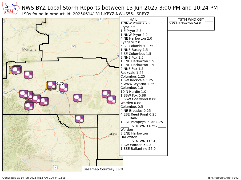
Preliminary Local Storm Report...Summary
National Weather Service Billings MT
711 AM MDT Sat Jun 14 2025

..TIME...   ...EVENT...      ...CITY LOCATION...     ...LAT.LON...
..DATE...   ....MAG....      ..COUNTY LOCATION..ST.. ...SOURCE....
            ..REMARKS..

1019 PM     Hail             6 WNW Wyarno            44.85N 106.87W
06/13/2025  M1.25 Inch       Sheridan           WY   Public


0610 PM     Tstm Wnd Gst     4 SW Worden             45.93N 108.23W
06/13/2025  E58 MPH          Yellowstone        MT   Mesonet


0615 PM     Hail             Worden                  45.97N 108.17W
06/13/2025  E0.88 Inch       Yellowstone        MT   Public

            Time estimated by radar.

0615 PM     Tstm Wnd Gst     1 SSE Ballantine        45.94N 108.15W
06/13/2025  M57 MPH          Yellowstone        MT   Mesonet

            Mesonet station MTBAL Ballantine I-94 Mp
            15.0.

0616 PM     Tstm Wnd Dmg     Worden                  45.97N 108.17W
06/13/2025                   Yellowstone        MT   Public

            Tree limbs down and small objects thrown
            around.

0821 PM     Rain             1 ESE Pompeys Pillar    45.99N 107.93W
06/13/2025  M1.75 Inch       Yellowstone        MT   Trained Spotter


0300 PM     Tstm Wnd Gst     5 W Harlowton           46.45N 109.94W
06/13/2025  M54 MPH          Wheatland          MT   Mesonet

            Mesonet station UMHM 5.1 W Harlowton
            (AGRIMET).

0305 PM     Tstm Wnd Dmg     3 ENE Harlowton         46.46N 109.78W
06/13/2025                   Wheatland          MT   Emergency Mngr

            EM report of multiple structures with lost
            roofs, uprooted trees as well as tree limb
            damage.

0305 PM     Hail             4 NE Harlowton          46.47N 109.77W
06/13/2025  M2.00 Inch       Wheatland          MT   Emergency Mngr


0310 PM     Tstm Wnd Dmg     Harlowton               46.44N 109.83W
06/13/2025                   Wheatland          MT   Public

            Corrects previous non-tstm wnd dmg report
            from Harlowton. Power lines down with some
            power outages reported.

0320 PM     Hail             1 ENE Harlowton         46.44N 109.82W
06/13/2025  E1.50 Inch       Wheatland          MT   Trained Spotter


0550 PM     Hail             4 ESE Reed Point        45.67N 109.47W
06/13/2025  E0.25 Inch       Stillwater         MT   Cocorahs


0605 PM     Hail             Columbus                45.64N 109.25W
06/13/2025  E0.50 Inch       Stillwater         MT   Public

            Report from mPING: Half-inch (0.50 in.).

0606 PM     Hail             Columbus                45.64N 109.25W
06/13/2025  E1.00 Inch       Stillwater         MT   Public


0615 PM     Hail             Columbus                45.64N 109.25W
06/13/2025  E1.25 Inch       Stillwater         MT   Public


0620 PM     Hail             5 SE Columbus           45.59N 109.19W
06/13/2025  E1.75 Inch       Stillwater         MT   Public

            Report from mPING: Golf Ball (1.75 in.).

0628 PM     Hail             6 SE Columbus           45.58N 109.17W
06/13/2025  M1.50 Inch       Stillwater         MT   Public


0926 PM     Hail             5 SSW Coalwood          45.67N 105.62W
06/13/2025  M0.88 Inch       Powder River       MT   Cocorahs


1024 PM     Hail             4 NE Broadus            45.49N 105.36W
06/13/2025  E0.25 Inch       Powder River       MT   Trained Spotter


0420 PM     Hail             Ryegate                 46.30N 109.25W
06/13/2025  E2.00 Inch       Golden Valley      MT   Public

            Time estimated by radar.

0640 PM     Hail             1 SW Rockvale           45.51N 108.88W
06/13/2025  M1.25 Inch       Carbon             MT   Public


0645 PM     Hail             2 NNE Fox               45.31N 109.20W
06/13/2025  E1.50 Inch       Carbon             MT   Public


0648 PM     Hail             3 NNE Fox               45.31N 109.20W
06/13/2025  E1.50 Inch       Carbon             MT   Public


0652 PM     Hail             Rockvale                45.52N 108.86W
06/13/2025  E1.25 Inch       Carbon             MT   Public

            Report from mPING: Half Dollar (1.25 in.).

0658 PM     Hail             1 SSW Fox               45.27N 109.23W
06/13/2025  M0.88 Inch       Carbon             MT   Public


0708 PM     Hail             Pryor                   45.42N 108.53W
06/13/2025  E2.50 Inch       Big Horn           MT   Public


0710 PM     Hail             1 NNW Pryor             45.43N 108.54W
06/13/2025  M2.75 Inch       Big Horn           MT   NWS Employee


0710 PM     Hail             10 N Hardin             45.88N 107.60W
06/13/2025  M1.00 Inch       Big Horn           MT   Trained Spotter


0711 PM     Hail             1 E Pryor               45.43N 108.51W
06/13/2025  E2.50 Inch       Big Horn           MT   Public

            Report from mPING: Tennis Ball (2.50 in.).

0715 PM     Hail             1 NNW Pryor             45.43N 108.54W
06/13/2025  E2.00 Inch       Big Horn           MT   NWS Employee


0800 PM     Hail             1 NNE Busby             45.54N 106.95W
06/13/2025  E1.50 Inch       Big Horn           MT   Trained Spotter


&&

$$