
Much higher than typical October temperatures will continue across coastal southern California up through the Bay Area and Central Valley through midweek resulting in result in Major to Extreme HeatRisk. A tropical depression is likely to form over the Gulf of America during the middle part of this week with further strengthening possible as it moves northeastward later this week. Read More >
| August 8, 2013 Nashville Metro Flash Flood |
| Overview | |||
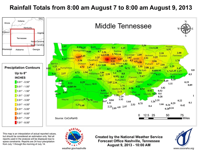
| A localized but major flash flood struck the northern Nashville metro area in the early morning hours of August 8. Thunderstorms formed along a weak stationary front situated just north of the I-40 corridor early in the day, then continued to redevelop and move across the same areas through the morning hours. Rainfall totals ranging from 2 to 8 inches resulted along a narrow swath including northern Nashville, Whites Creek, Bordeaux, Inglewood, and Goodlettsville eastward to parts of Hendersonville and Mount Juliet. | |||
| Davidson County Flash Flood | |||
|
More than 100 homes and businesses were damaged and a couple homes destroyed by significant flash flooding across metro Nashville. There were dozens of water rescues across the city, including along Interstate 24 and Briley Parkway where several motorists had to be rescued. All told, Nashville OEM responded to over 200 calls for help from residents. |
|||
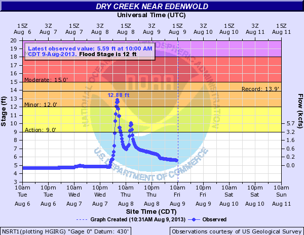 Dry Creek at Edenwold TN river gauge |
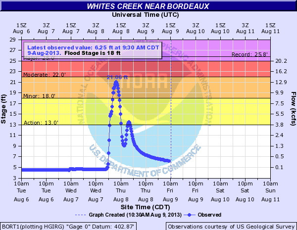 Whites Creek at Bordeaux TN river gauge |
||
| Wilson County Flash Flood | |
|
Major flash flooding impacted much of northern Wilson County during the morning and early afternoon hours on August 8 after 5 to 7 inches of rain fell across the area. The worst flooding was across Mount Juliet, where dozens of roads were covered by several feet of water and closed, and some homes and businesses were flooded. Road that were closed included Needmore Road, Division Street, Woodridge Place, Curd Road, Old Lebanon Dirt Road, Mount Juliet Road, Cairo Bend Road, York Road, Cooks Road, and Northern Road. Businesses flooded included the Valley Center strip mall on Mount Juliet Road at Division Street. |



 Follow us on X
 Follow us on Facebook
 Follow us on YouTube
 OHX RSS Feed