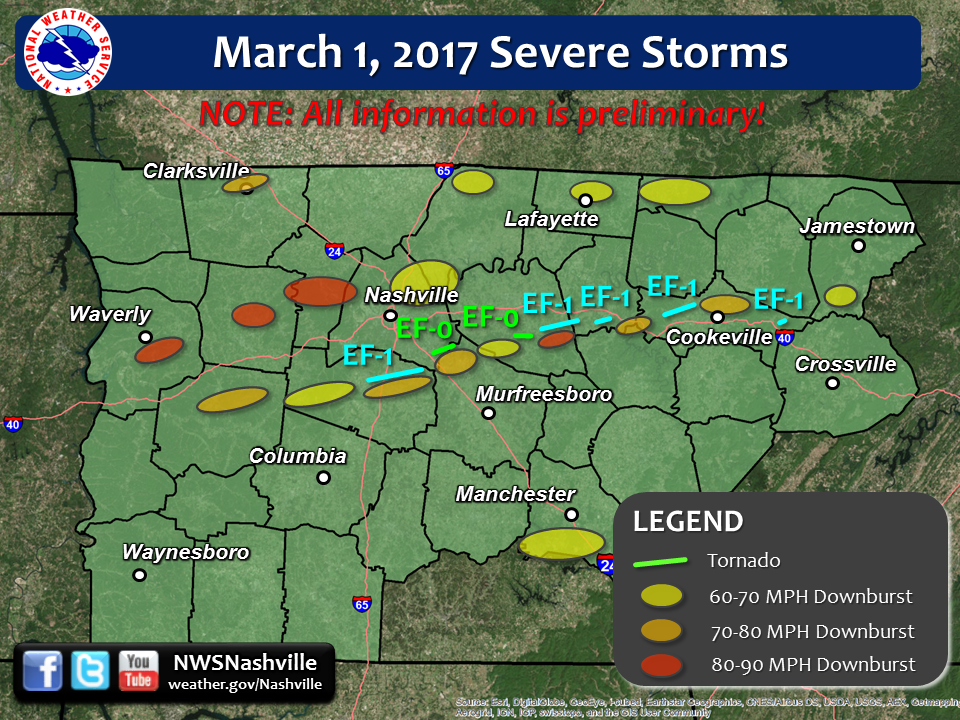
| Tornado Statistics | ||||||||
| # | Counties | Rating | Time (CST) | Length (miles) | Width (yards) | Fatalities | Injuries | |
| 1 | Williamson | EF1 | 0700 | 10.5 | 250 | 0 | 0 | |
| 2 | Davidson/Rutherford | EF0 | 0717 | 3.38 | 75 | 0 | 0 | |
| 3 | Wilson | EF0 | 0737 | 3.33 | 100 | 0 | 0 | |
| 4 | Wilson/Smith | EF1 | 0740 | 6.69 | 200 | 0 | 0 | |
| 5 | Smith | EF1 | 0751 | 3.91 | 200 | 0 | 0 | |
| 6 | Putnam | EF1 | 0804 | 7.67 | 150 | 0 | 0 | |
| 7 | Putnam | EF1 | 0835 | 0.90 | 100 | 0 | 0 | |
| Overview | |
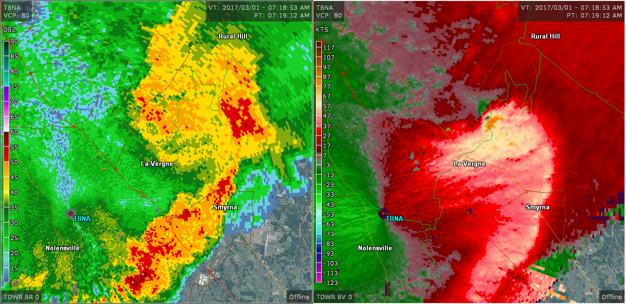
| The most damaging severe weather outbreak in Middle Tennessee since the December 23, 2015 Tornado Outbreak struck during the morning hours on March 1, 2017. A line of strong to severe thunderstorms with embedded circulations, known as a Quasi-Linear Convective System (or QLCS), moved rapidly across Middle Tennessee at 60-70 mph from west to east between 6 AM and 10 AM CST. Additional severe thunderstorms developed later in the morning and affected areas of southern Middle Tennessee from the late morning into the early afternoon hours. Widespread damaging winds were reported in nearly every county along and north of I-40 across Middle Tennessee, with winds estimated up to 90 mph in some areas. These intense downburst winds caused 3 injuries - two in Clarksville when a tree fell on a mobile home, and one in Lavergne when a tractor trailer flipped over. In addition to the damaging winds, 7 confirmed tornadoes also touched down from the Nashville metro area eastward to the Upper Cumberland, damaging hundreds of homes and businesses. Several reports of large hail were also received in parts of southern Middle Tennessee. |
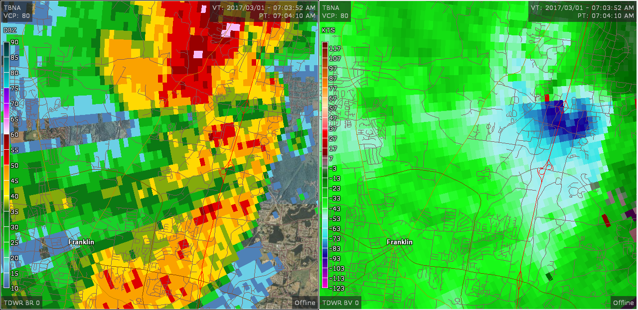
| Radar | |||
|
|||
| Reports & Outlooks | ||||
| SPC Storm Reports | SPC Event Archive | GIS Damage Map | Local Storm Reports | Public Information Statements |
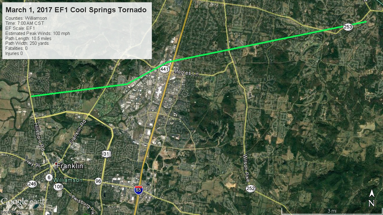
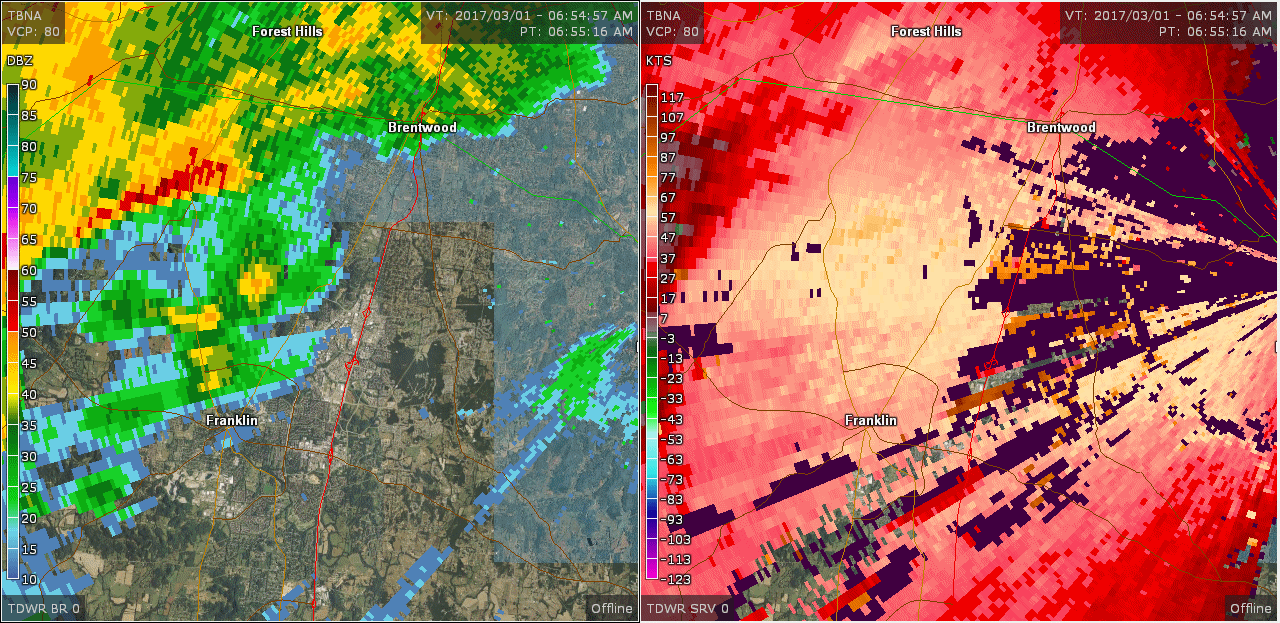
| EF1 Cool Springs Tornado | |
| Counties: | Williamson |
| Time: | 7:00 AM CST |
| EF Scale: | EF1 |
| Estimated Peak Winds: | 100 mph |
| Path Length: | 10.5 miles |
| Path Width: | 250 yards |
| Fatalities: | 0 |
| Injuries: | 0 |
|
Storm Survey: An EF-1 tornado touched down along Hillsboro Road just northwest of the city of Franklin, then moved rapidly east-northeast across the Cool Springs and Brentwood areas of northern Williamson County before lifting just west of the Davidson County line. The first evidence of damage was several trees blown down in the Monticello neighborhood on Poteat Place and Spencer Creek Road near Hillsboro Road. Two sheds were destroyed and more trees snapped and uprooted along South Berrys Chapel Road. Several more trees were blown down and an outbuilding damaged along Mallory Station Road and Jackson Lake Drive, and numerous homes suffered minor to moderate roof, siding, and chimney damage along Sunrise Circle and Brentwood Pointe. Several businesses suffered damage along Mallory Lane and Galleria Boulevard including blown out garage doors and roof damage, and a video of the tornado was taken from a car dashcam on Commerce Way. The tornado then weakened as it crossed Interstate 65, but still blew down seven interstate highway signs along the roadway. As the tornado moved through Brentwood, it continued to blow down trees and cause minor damage to homes and businesses on Westgate Circle, Gordon Petty Drive, Wilson Pike, Demery Court, Crockett Road, and in the Governor's Club neighborhood. The tornado then intensified as it traveled down Concord Road, with dozens of trees snapped and uprooted and numerous homes suffering roof and exterior damage. The tornado then lifted near Owl Creek Park along Chestnut Springs Road just before reaching the Davidson County line. Preliminary estimates from Williamson County Emergency Management indicated that 472 homes and businesses received minor damage, 49 sustained moderate damage, and one home on Sunrise Circle suffered major damage for a total of 522 damaged structures. Damage totals are estimated at 7.27 million dollars. South of the tornado track, a large downburst associated with the rear flank downdraft of the Cool Springs tornado also caused damage across the Cool Springs area of Franklin and Brentwood. Many trees were snapped or uprooted on Crossroads Boulevard and Mallory Lane near the Cool Springs Galleria. The ceiling of the drive through portion of a bank at the southwest corner of Bakers Bridge Avenue and Mallory Lane collapsed, and one HVAC unit was blown off an HH Gregg store on Galleria Boulevard causing interior roof and water damage. Dozens of trees were snapped and uprooted along Moores Lane from the Nashville Golf Club to Primm Park, and outbuildings at a farm on Moores Lane at Montclair Boulevard suffered roof damage. Winds in this 3 mile long by 1 mile wide downburst were estimated around 80 mph. |
|
 |
 |
| EF0 Four Corners Marina Tornado | |
| Counties: | Davidson/Rutherford |
| Time: | 7:17 AM CST |
| EF Scale: | EF0 |
| Estimated Peak Winds: | 85 mph |
| Damage Path Length: | 3.38 miles |
| Damage Path Width: | 75 yards |
| Fatalities: | 0 |
| Injuries | 0 |
|
Storm Survey: An EF-0 tornado touched down in extreme southeast Davidson County along Maxwell Road. It caused sporadic damage mainly to trees as it raced to the northeast, although a few homes suffered minor roof damage on Lavergne Couchville Pike. It then hit the Four Corners Marina around 719am CST and caused extensive damage to docks, boats and shelters. The tornado crossed the Hurricane Creek inlet of Percy Priest Lake and moved across the Lake Forest subdivision, causing generally minor roof damage to a few homes, blowing down scattered trees, and destroying a few outbuildings along Randall Lane, Brent Cove, Hollandale Road, and Angel Way Court before lifting. To the south of the tornado track, a large area of severe downburst winds estimated at 60-80 mph also caused considerable wind damage, including minor damage to homes on Pepperwood Drive, Chutney Drive, and Frontier Lane. This tornado track was updated and adjusted significantly from official Storm Data records in May 2020 based on a radar reanalysis and newly available high resolution Google Earth satellite imagery South of the tornado track, a large downburst associated with the rear flank downdraft of the Cool Springs and Four Corners Marina tornadoes caused damage across a wide swath of northeast Williamson, far southeast Davidson, and far northwest Rutherford Counties. In Williamson County, dozens of trees were snapped and uprooted from the Concord Pass area across Waller Road, Forest Trail, and Nolensville Pike, with minor roof and siding damage to numerous homes and a few trees falling on outbuildings and houses. One duplex on Nolensville Pike was heavily damaged by multiple trees falling onto it. In Davidson County, trees and power poles were blown down on Pettus Road, and several other trees were snapped and uprooted on Burkitt Road and near Cane Ridge Park. TDOT reported trees down at 13390 Old Hickory Blvd. Several tall power poles were blown down on Nashville Highway near Hickory Woods Drive, and scattered trees were snapped or uprooted in the Hickory Woods Estates and Peppertree Forest subdivisions. In Rutherford County, a large truck parked at 1325 Heil Quaker Road in La Vergne was blown over, injuring a man inside who was transported to the hospital. Scattered trees were also snapped and uprooted across the Lake Forest subdivision, where one house was severely damaged by a fallen tree on Frontier Lane. Winds in this 12 mile long by 2 mile wide downburst were estimated around 80 mph. |
|
 |
 |
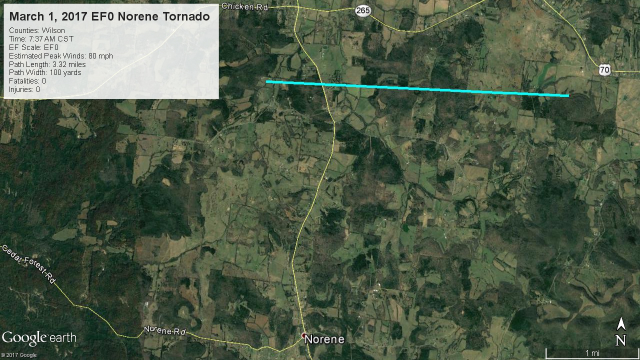
| EF0 Wilson County Tornado | |
| Counties: | Wilson |
| Time: | 7:37 AM CST |
| EF Scale: | EF0 |
| Estimated Peak Winds: | 80 mph |
| Damage Path Length: | 3.33 miles |
| Damage Path Width: | 100 yards |
| Fatalities: | 0 |
| Injuries | 0 |
|
Storm Survey: Using Google Earth high resolution satellite imagery along with OHX and TBNA radar data, an EF-0 tornado was determined to have touched down 6.6 miles west of Watertown north of Burnt House Road (south of Shop Springs). This tornado then moved due east across Cainsville Road and rural areas north of Beech Log Road before dissipating into a severe downburst south of Taylor Road, around 3.3 miles west of Watertown. Dozens of trees were snapped and uprooted in all directions in a clearly convergent pattern along the path. One outbuilding was destroyed near a home on Cainsville Road with debris blown towards the north. With most of the path over inaccessible rural areas of Wilson County with no roads, this tornado could only have been determined using the high resolution satellite imagery. |
|
 |
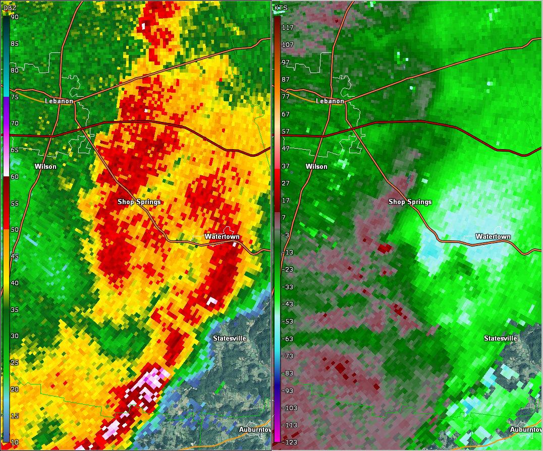 |
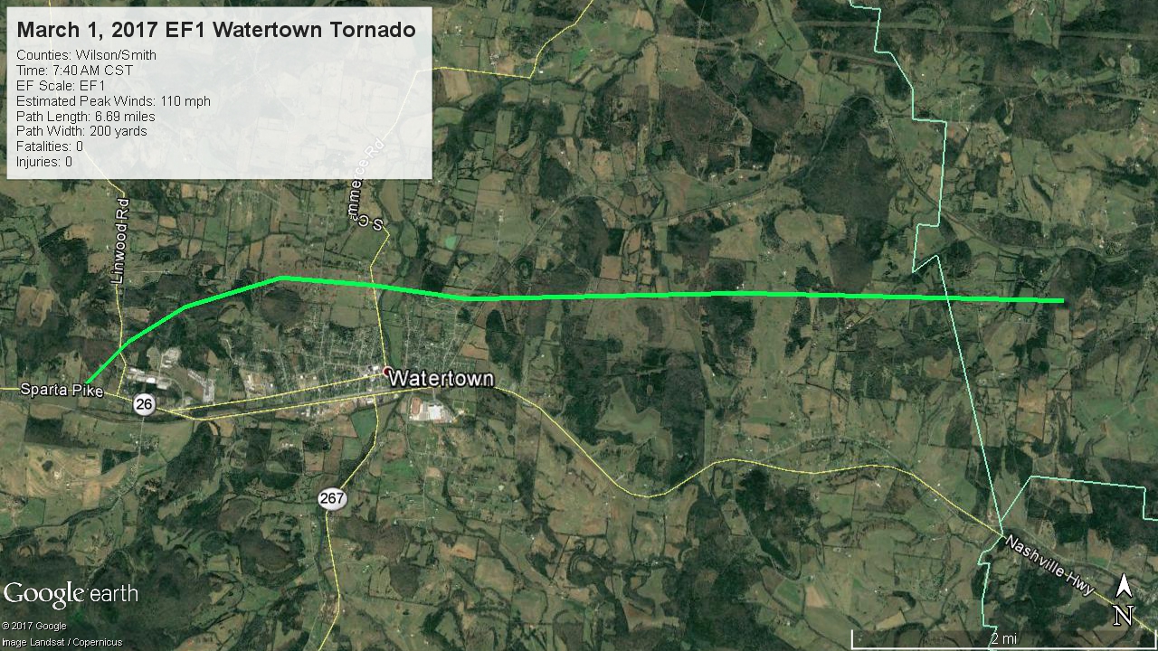
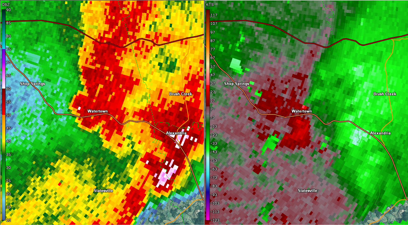
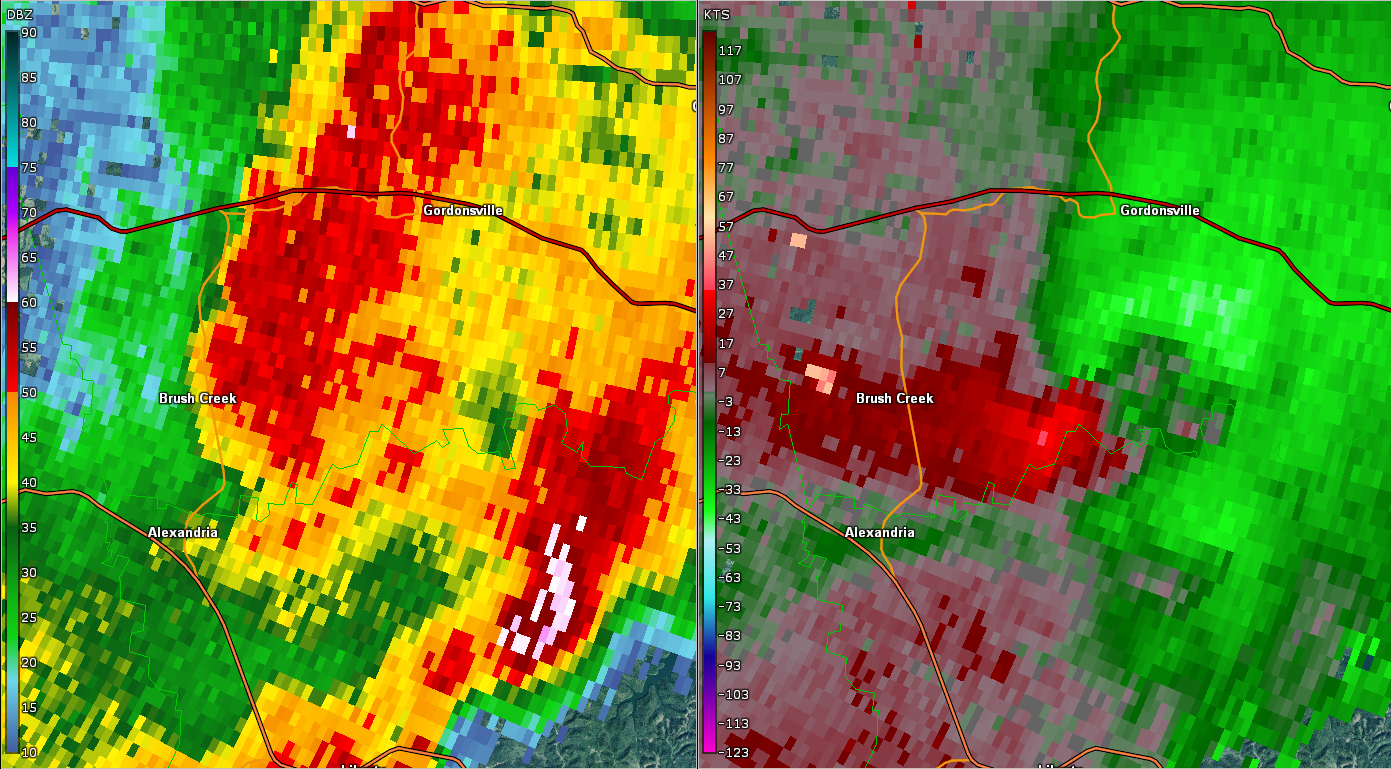
| EF1 Watertown Tornado | |
| Counties: | Wilson/Smith |
| Time: | 7:40 AM CST |
| EF Scale: | EF1 |
| Estimated Peak Winds: | 110 mph |
| Damage Path Length: | 6.69 miles |
| Damage Path Width: | 200 yards |
| Fatalities: | 0 |
| Injuries | 0 |
|
Storm Survey: An NWS Storm Survey along with Google Earth high resolution satellite data and radar data determined a high end EF-1 tornado touched down in Wilson County just north of Highway 70 (Sparta Pike) in far western Watertown, then curved northeast and east across the northern fringes of the town. One home suffered considerable roof damage at 7077 Sparta Pike and a carport was destroyed at a neighboring home. Another mobile home had most of its metal roof blown off on Linwood Road and several trees were blown down on both sides of the roadway. The tornado intensified as it crossed New Town Road where 2 homes suffered roof damage and dozens of trees were snapped or uprooted in all directions. Another home had roof damage on Parkenson Road where many more trees were snapped and uprooted. The most severe damage occurred along South Commerce Road, where one home suffered considerable roof and siding damage, and the attached garage was knocked off the slab foundation and collapsed. However, the garage was not properly attached to the foundation. An adjacent barn was completely destroyed with debris blown over 200 yards to the southeast. Another barn further south on South Commerce Road was heavily damaged, and the wastewater plant across the road received minor damage. East of South Commerce Road, two wooden TVA high transmission power poles were snapped. A home sustained minor roof damage and a greenhouse was destroyed on the west side of Holmes Gap Road, while another home suffered heavy roof damage and an outbuilding was destroyed on the east side of the roadway. The tornado then weakened as it continued eastward, but still continued to blow down dozens of trees. An outbuilding suffered minor damage south of Hudson Road, and a large outbuilding was destroyed farther east at 850 Haley Road. Numerous more trees continued to be blown down across rural forests and fields to the east before the tornado crossed into Smith County. In Smith County, the tornado caused EF-0 damage as it crossed Holmes Gap Road around 2 miles southwest of Brush Creek. Two old barns sustained damage on the west side of the roadway, while another barn on the east side was destroyed. Numerous tree were also blown down in the area. The tornado continued to blow down trees in forests to the north of Switchboard Road before dissipating into a large downburst that affected areas south of Brush Creek. |
|
 |
 |
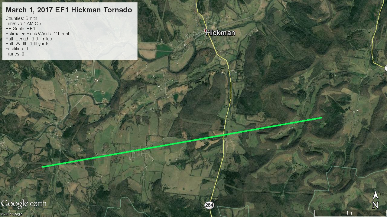
| EF1 Smith County Tornado | |
| Counties: | Smith |
| Time: | 7:51 AM CST |
| EF Scale: | EF1 |
| Estimated Peak Winds: | 110 mph |
| Damage Path Length: | 3.91 miles |
| Damage Path Width: | 200 yards |
| Fatalities: | 0 |
| Injuries | 0 |
|
Storm Survey: A NWS storm survey along with high resolution Google Earth satellite imagery confirmed an EF1 tornado touched down in far southern Smith County southwest of the town of Hickman just north of Potter Road. The tornado completely destroyed a 1930s-era home being used as a storage building to the west of Kyle Hollow Lane, with contents blown up to 150 yards away. Numerous trees were also snapped and uprooted around the building and a nearby mobile home sustained minor exterior damage. Three homes on Jenkins Hill Road just west of Hill Road suffered minor to moderate roof damage and two nearby outbuildings were destroyed. A nearby barn was destroyed and another barn suffered roof damage. On Highway 264 at Jenkins Hall Road, a large barn was completely destroyed with debris blown over 200 yards away to the north, and another barn suffered minor roof damage. TDOT also reported Highway 264 was blocked by trees blown down across the roadways. Farther to the east, dozens of trees were snapped and uprooted in the hills and valleys around Nabors Hollow Lane, and one home received considerable roof damage before the tornado lifted. Special thanks to Smith County Emergency Management and @SmithCountyWx for their assistance with this storm survey. |
|
 |
 |
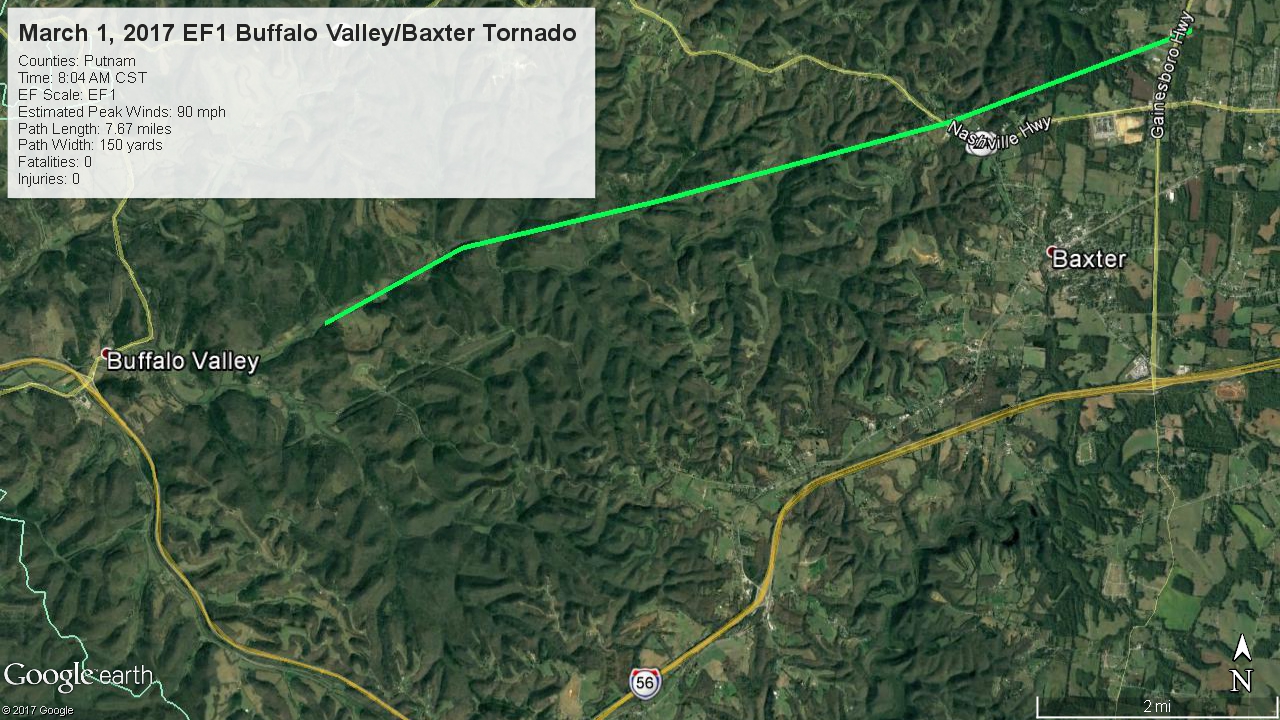
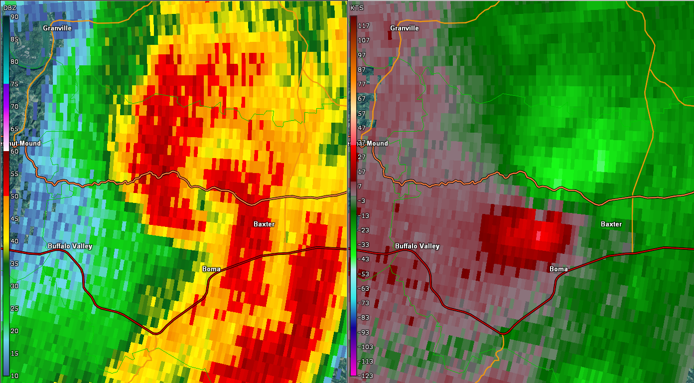
| EF1 Buffalo Valley/Baxter Tornado | |
| Counties: | Putnam |
| Time: | 8:04 AM CST |
| EF Scale: | EF1 |
| Estimated Peak Winds: | 90 mph |
| Damage Path Length: | 8.75 miles |
| Damage Path Width: | 150 yards |
| Fatalities: | 0 |
| Injuries | 0 |
|
Storm Survey: An EF-1 tornado touched down on Indian Creek Road near Stanton Road to the east of Buffalo Valley and continued east-northeast to near Baxter. Along Indian Creek Road, dozens of large trees were snapped and uprooted, a few homes had minor roof damage, and some small outbuildings were destroyed. Farther to the east near Baxter, a home suffered minor roof damage and barn was partially destroyed on Dyer Ridge Road. Debris from the barn was blown northward across Dyer Ridge Road into trees over 100 yards away. A large tree fell onto and destroyed a mobile home on Nashville Highway just east of Thompson Ridge Road, and numerous other trees were blown down in the area. The final damage was a collapsed large metal storage building on Highway 56 south of Higgenbottom Road north of Baxter. |
|
 |
 |
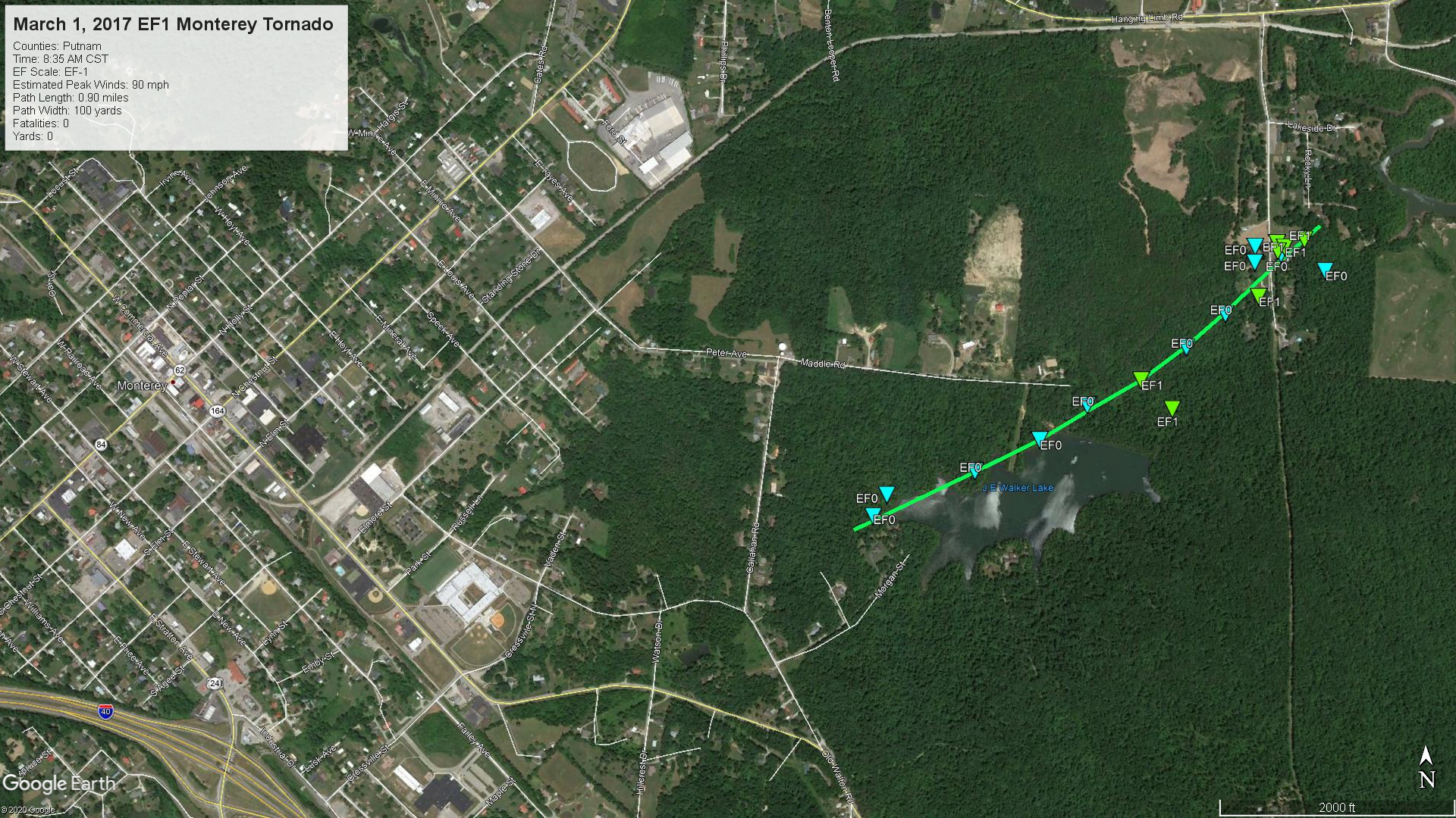
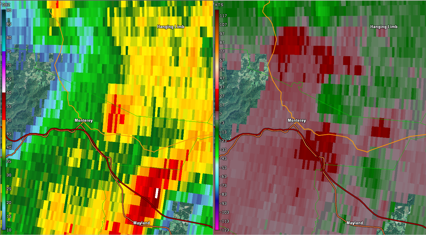
| EF1 Monterey Tornado | |
| Counties: | Putnam |
| Time: | 8:35 AM CST |
| EF Scale: | EF1 |
| Estimated Peak Winds: | 90 mph |
| Damage Path Length: | 0.90 miles |
| Damage Path Width: | 100 yards |
| Fatalities: | 0 |
| Injuries | 0 |
|
Storm Survey: A brief EF-1 tornado touched down on the west side of J.E. Walker Lake just east of Callahan Road on the east side of Monterey. Moving northeast, the tornado blew down dozens of trees along the north side of J.E. Walker Lake and west of Lake Hill Road. The tornado uprooted and snapped large trees in a very localized area.A mobile home received minor structural damage and a few outbuildings were destroyed on Lake Hill Road before the tornado lifted on the west side of the City of Monterey Lake. This tornado path was updated and extended in May 2020 due to newly available high resolution Google Earth satellite imagery. |
|
 |
 |

