May 26-27, 2024 Severe Storms
|
Several waves of strong to severe thunderstorms moved across Middle Tennessee throughout the day on Sunday, May 26 into the early morning hours on Monday, May 27. The worst damage occurred with the morning and afternoon rounds of storms, when widespread wind damage and large hail occurred across the northern half of Middle Tennessee. Some areas also received flash flooding as up to 4 inches of rain fell across parts of the region. All information is PRELIMINARY and subject to change! For more information on tornadoes across Middle Tennessee, visit our online tornado database at https://www.
|
|
Hail
|
Bon Aqua, TN
Hail Photos
|
||||||||||
|
Leipers Fork, TN
Hail Photos
|
||||||||||
Downbursts (Straight Line Winds)
|
Damaging Winds - Mitchellville, TN
Damage Photos 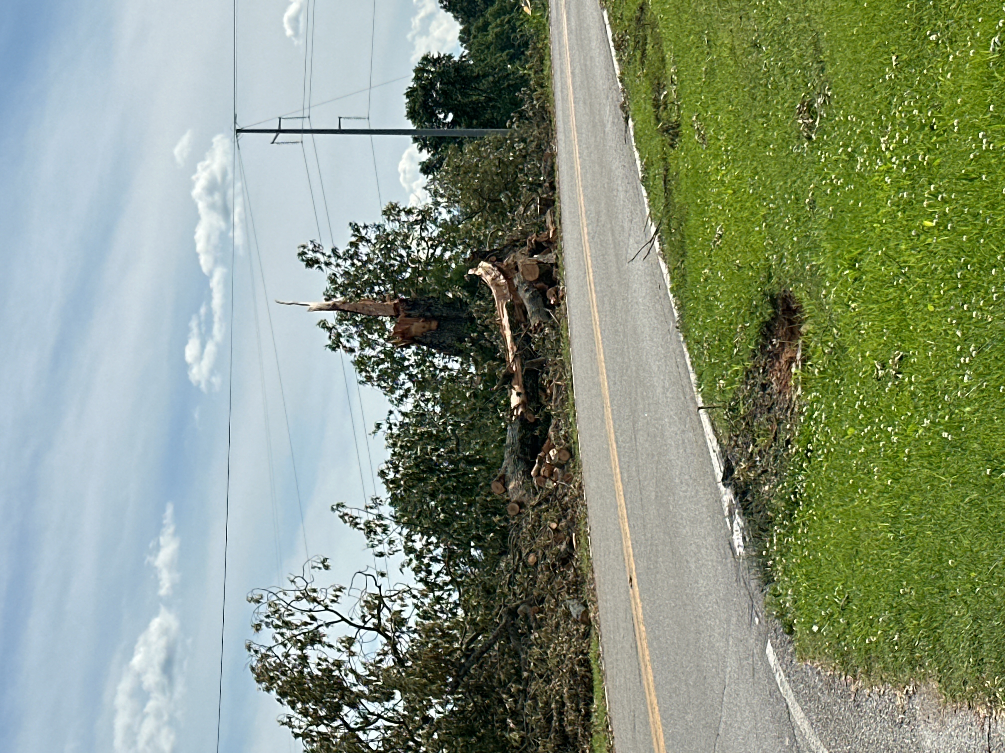
|
||||||||||
|
Damaging Winds - Pickett State Park
Damage Photos 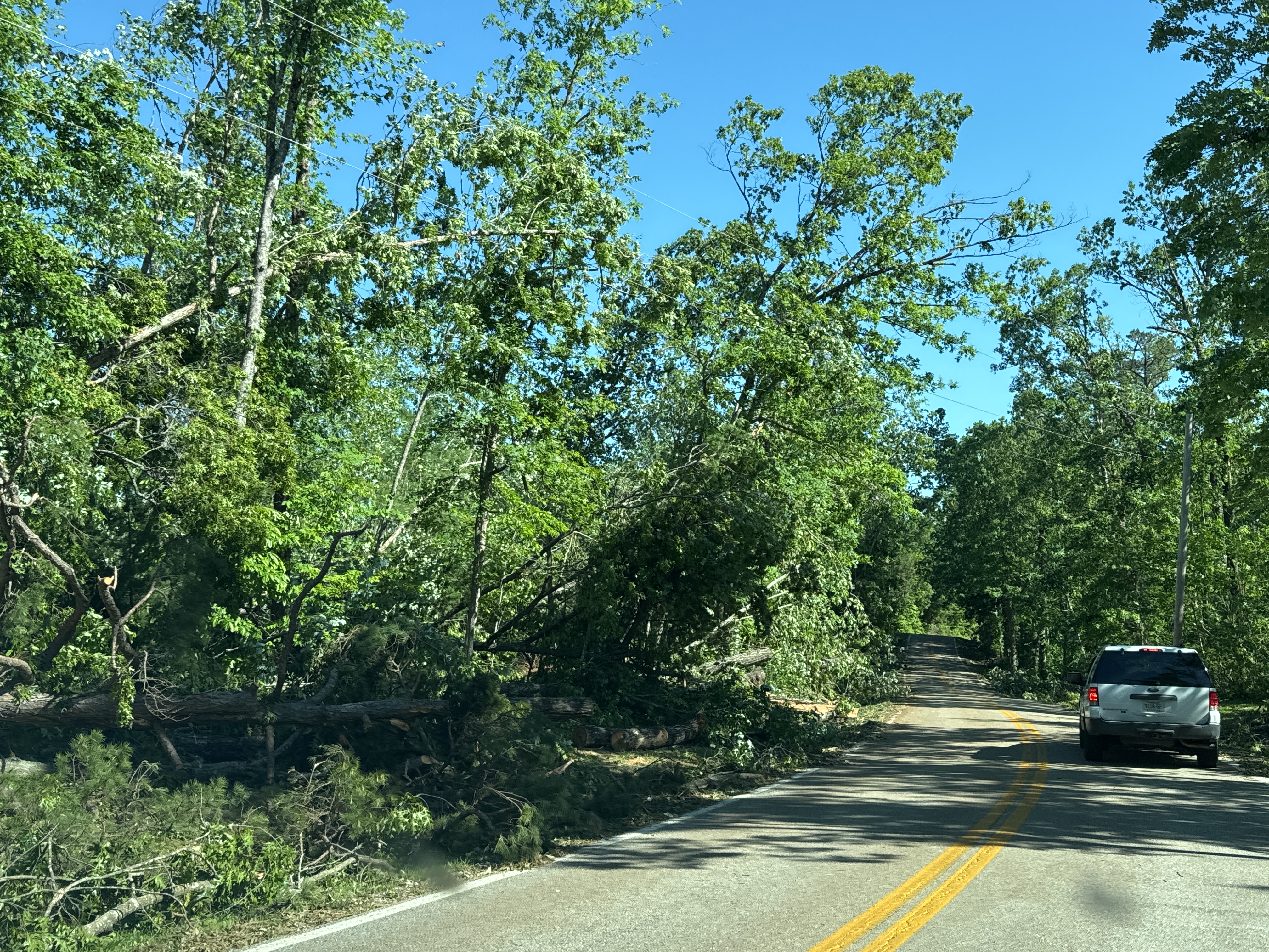
|
||||||||||
Damage Surveys
Public Information Statement
National Weather Service Nashville TN
1246 PM CDT Wed May 29 2024

...NWS Damage Survey for 5/26/2024 Thunderstorm Wind Event -
Update #1...

.Northern Sumner County Wind Damage...

Estimated Peak Wind:    75 mph
Fatalities:             0
Injuries:               0

Date:                   05/26/2024
Time:                   9:57 AM to 10:15 AM CDT
Location:               1 W Mitchellville to 5 NNW Westmoreland
Lat/Lon:                36.63 / -86.54

Survey Summary: A line of severe thunderstorms moved across
northern Sumner County late Sunday morning causing widespread
wind damage to trees and power lines. A NWS storm survey found a
large 1.5 mile wide by 11 mile long downburst blew down dozens of
trees and power lines from west of Mitchellville to the Kentucky
border north of Westmoreland. Some trees fell onto homes causing
substantial damage. Winds were estimated up to 75 mph.


.Overton, Pickett, and Fentress County Wind Damage...

Estimated Peak Wind:    85 mph
Fatalities:             0
Injuries:               0

Date:                   05/26/2024
Time:                   11:26 AM to 11:53 AM CDT
Location:               Pickett CCC Memorial State Park
Lat/Lon:                36.55 / -84.80

Survey Summary: A line of severe thunderstorms moved over
northern Overton, Pickett, and northern Fentress Counties late
Sunday morning, causing widespread wind damage to trees, power
lines, and some outbuildings. The worst damage occurred across
eastern Pickett and northeast Fentress Counties where a NWS storm
survey found a large 2.5 mile wide by 7 mile long downburst and
embedded stronger microbursts blew down hundreds of trees in and
around Pickett State Park and Big South Fork Recreation Area. The
park was temporarily closed due to all roads being blocked by
downed trees. Winds were estimated up to 85 mph. Thank you to
Fentress County EMA and Fentress County Fire Dept for assisting
with this survey.

&&

NOTE:
The information in this statement is preliminary and subject to
change pending final review of the event and publication in NWS
Storm Data.


$$

Husted/Shamburger
Local Storm Reports
Preliminary Local Storm Report...Summary
National Weather Service Nashville TN
151 PM CDT Wed May 29 2024

..TIME...   ...EVENT...      ...CITY LOCATION...     ...LAT.LON...
..DATE...   ....MAG....      ..COUNTY LOCATION..ST.. ...SOURCE....
            ..REMARKS..

0848 AM     Tstm Wnd Dmg     7 WSW Bumpus Mills      36.58N 87.95W
05/26/2024                   Stewart            TN   Trained Spotter

            Sportter reported trees and power lines down
            between Mile Markers 2-5 on the Woodland
            Trace Scenic Byway in Land Between the
            Lakes.

0854 AM     Tstm Wnd Dmg     Bumpus Mills            36.61N 87.84W
05/26/2024                   Stewart            TN   Emergency Mngr

            Emergency Management reported trees down and
            power outages on north end of Stewart
            County.

0915 AM     Tstm Wnd Dmg     3 ENE Clarksville       36.57N 87.30W
05/26/2024                   Montgomery         TN   Emergency Mngr

            Delayed report. Trees and powerlines down, a
            couple trees fell on houses and one fell on
            an apartment complex.

0942 AM     Tstm Wnd Dmg     2 SW Springfield        36.48N 86.91W
05/26/2024                   Robertson          TN   Emergency Mngr

            Large tree on house reported on the 3200
            block of Blurr Rd, south-southwest of
            Springfield.

0942 AM     Tstm Wnd Dmg     3 S Clarksville         36.51N 87.33W
05/26/2024                   Montgomery         TN   Public

            Report from mPING: 1-inch tree limbs broken;
            Shingles blown off.

0944 AM     Tstm Wnd Dmg     3 SE Clarksville        36.52N 87.33W
05/26/2024                   Montgomery         TN   Public

            Report from mPING: 3-inch tree limbs broken;
            Power poles broken.

0948 AM     Tstm Wnd Dmg     4 SE Clarksville        36.51N 87.32W
05/26/2024                   Montgomery         TN   Public

            Report from mPING: Trees uprooted or
            snapped; Roof blown off.

0951 AM     Tstm Wnd Dmg     2 W Orlinda             36.60N 86.72W
05/26/2024                   Robertson          TN   Emergency Mngr

            Reports of trees and power lines down in and
            north of Orlinda.

0951 AM     Tstm Wnd Dmg     2 NNW Orlinda           36.62N 86.69W
05/26/2024                   Robertson          TN   Emergency Mngr

            Trees down on Clay Gregory Rd northeast of
            Orlinda.

0952 AM     Tstm Wnd Dmg     2 NE Orlinda            36.62N 86.65W
05/26/2024                   Robertson          TN   Emergency Mngr

            Trees down on Highland Rd east-northeast of
            Orlinda.

0957 AM     Tstm Wnd Dmg     Mitchellville           36.63N 86.54W
05/26/2024                   Sumner             TN   Fire Dept/Rescue

            Trees and power lines are down in the center
            of Mitchellville on Main St.

0958 AM     Tstm Wnd Dmg     Mitchellville           36.63N 86.54W
05/26/2024                   Sumner             TN   NWS Storm Survey

            NWS storm survey found a large 1.5 mile wide
            by 11 mile long downburst blew down dozens
            of trees and power lines across northern
            Sumner County, from west of Mitchellville to
            the Kentucky border north of Westmoreland.
            Some trees fell onto homes causing
            substantial damage. Max winds were estimated
            up to 75 mph.

1044 AM     Tstm Wnd Dmg     8 WNW Celina            36.60N 85.64W
05/26/2024                   Clay               TN   Emergency Mngr

            Power lines down on Hwy 52 in Moss.

1104 AM     Tstm Wnd Dmg     Celina                  36.54N 85.51W
05/26/2024                   Clay               TN   Emergency Mngr

            Trees down on Mitchell Street in Celina.

1120 AM     Tstm Wnd Dmg     7 WNW Livingston        36.44N 85.44W
05/26/2024                   Overton            TN   Public

            Numerous trees were blown down along Heard
            Ridge Road.

1122 AM     Tstm Wnd Dmg     6 SW Byrdstown          36.51N 85.22W
05/26/2024                   Pickett            TN   NWS Storm Survey

            NWS storm survey found scattered trees were
            blown down across central Pickett and
            northern Overton Counties, including on
            Jolley Road, Iron Creek Rd, C Parker Rd,
            Raymond Rd, Keisling Ridge Rd. A barn was
            destroyed on Hatcher Hall Rd. Winds were
            estimated up to 70 mph.

1140 AM     Tstm Wnd Dmg     7 NW Jamestown          36.49N 85.03W
05/26/2024                   Fentress           TN   Public

            Trees were blown down along Double Top Road.

1144 AM     Tstm Wnd Dmg     1 N Jamestown           36.45N 84.94W
05/26/2024                   Fentress           TN   Emergency Mngr

            Widespread trees down, some power poles down
            as well.

1146 AM     Tstm Wnd Dmg     12 NE Jamestown         36.56N 84.80W
05/26/2024                   Pickett            TN   Emergency Mngr

            Widespread trees down in the area of Pickett
            State Park.

1150 AM     Tstm Wnd Dmg     11 NE Jamestown         36.55N 84.80W
05/26/2024                   Pickett            TN   NWS Storm Survey

            NWS storm survey found a large 2.5 mile wide
            by 7 mile long downburst with embedded
            stronger microbursts blew down hundreds of
            trees across northeast Fentress and eastern
            Pickett Counties, especially in Pickett
            State Park and Big South Fork Recreation
            Area. The park was temporarily closed due to
            all roads being blocked by downed trees. Max
            winds were estimated up to 85 mph.

1255 PM     Hail             5 NNE Fredonia          36.50N 87.17W
05/26/2024  M1.00 Inch       Montgomery         TN   Public

            Large hail was reported along I-24 near
            Clarksville.

0102 PM     Hail             1 NW Adams              36.59N 87.07W
05/26/2024  E1.50 Inch       Robertson          TN   Public

            Large hail fell in Adams.

0117 PM     Hail             1 NW Coopertown         36.45N 86.98W
05/26/2024  M1.50 Inch       Robertson          TN   Emergency Mngr

            Ping pong ball sized hail falling near
            Coopertown.

0206 PM     Flash Flood      3 NNW Greenbrier        36.47N 86.81W
05/26/2024                   Robertson          TN   Emergency Mngr

            Video received of portions of Old Greenbrier
            Pike at Worsham Springs Rd. underwater.

0231 PM     Hail             3 N Bon Aqua            35.99N 87.32W
05/26/2024  M1.00 Inch       Dickson            TN   Emergency Mngr


0233 PM     Hail             Bon Aqua                35.96N 87.32W
05/26/2024  E1.75 Inch       Hickman            TN   Trained Spotter

            Received via tSpotter.

0238 PM     Hail             Bon Aqua                35.95N 87.33W
05/26/2024  M2.25 Inch       Hickman            TN   Trained Spotter

            Photos showed hail measured up to 2.25
            inches fell in Bon Aqua.

0246 PM     Hail             Fairview                35.98N 87.13W
05/26/2024  M2.00 Inch       Williamson         TN   Public


0248 PM     Hail             2 SE Fairview           35.96N 87.11W
05/26/2024  E1.00 Inch       Williamson         TN   Public


0249 PM     Hail             Fairview                35.98N 87.13W
05/26/2024  E1.75 Inch       Williamson         TN   Public


0256 PM     Hail             8 W Franklin            35.90N 86.99W
05/26/2024  E1.00 Inch       Williamson         TN   Public

            Report from mPING: Quarter (1.00 in.).

0256 PM     Hail             3 ESE Fairview          35.95N 87.08W
05/26/2024  E1.75 Inch       Williamson         TN   Public


0302 PM     Hail             9 WSW Franklin          35.90N 86.99W
05/26/2024  M2.00 Inch       Williamson         TN   Trained Spotter

            Actually 2.25 inches in diameter.

0305 PM     Hail             4 W Franklin            35.93N 86.91W
05/26/2024  E1.75 Inch       Williamson         TN   Trained Spotter


0305 PM     Hail             9 SE Fairview           35.90N 87.00W
05/26/2024  E3.00 Inch       Williamson         TN   Broadcast Media

            Media reports and photos showed hail up to 3
            inches in diameter fell in the Leipers Fork
            area. Many vehicles had windows broken or
            were heavily dented.

0309 PM     Hail             Gainesboro              36.36N 85.65W
05/26/2024  E0.70 Inch       Jackson            TN   Emergency Mngr


0314 PM     Hail             1 ESE Franklin          35.93N 86.83W
05/26/2024  E1.25 Inch       Williamson         TN   Trained Spotter


0322 PM     Hail             2 SSW Brentwood         35.97N 86.81W
05/26/2024  E1.00 Inch       Williamson         TN   Trained Spotter


0328 PM     Hail             4 NE College Grove      35.86N 86.62W
05/26/2024  E2.00 Inch       Williamson         TN   Trained Spotter


0340 PM     Hail             4 WSW Murfreesboro      35.84N 86.47W
05/26/2024  E1.25 Inch       Rutherford         TN   Public


0340 PM     Hail             4 W Murfreesboro        35.86N 86.47W
05/26/2024  E0.88 Inch       Rutherford         TN   Trained Spotter


0345 PM     Hail             2 SSW Murfreesboro      35.83N 86.41W
05/26/2024  M1.50 Inch       Rutherford         TN   Trained Spotter


0347 PM     Hail             2 W Murfreesboro        35.85N 86.44W
05/26/2024  M1.75 Inch       Rutherford         TN   Public

            Report from mPING: Golf Ball (1.75 in.).

0410 PM     Hail             3 NE Bradyville         35.77N 86.13W
05/26/2024  E1.00 Inch       Cannon             TN   Public

            Tspotter video showed hail up to quarter
            size fell in the Burt area of southwest
            Cannon County.

0425 PM     Hail             4 SE Woodbury           35.79N 86.02W
05/26/2024  M0.75 Inch       Cannon             TN   Trained Spotter


1054 PM     Tstm Wnd Dmg     4 NE Greenbrier         36.48N 86.78W
05/26/2024                   Robertson          TN   Public

            Report from mPING: 1-inch tree limbs broken;
            Shingles blown off.

1130 PM     Tstm Wnd Dmg     Portland                36.59N 86.52W
05/26/2024                   Sumner             TN   Amateur Radio

            Large tree down blocking both lanes at
            Highway 52/Old Highway 52...power out in
            North Portland.

1154 PM     Tstm Wnd Dmg     White House             36.46N 86.67W
05/26/2024                   Robertson          TN   Public

            Power outages in White House due to a downed
            tree on Highway 76.

1215 AM     Tstm Wnd Dmg     Byrdstown               36.57N 85.13W
05/27/2024                   Pickett            TN   Public

            Pickett County EMA reported scattered trees
            down across the county.

0126 AM     Tstm Wnd Dmg     Sparta                  35.93N 85.47W
05/27/2024                   White              TN   Emergency Mngr

            Tree down near Old Smithville Hwy N and
            Oaklawn Cemetery Rd.

0220 AM     Tstm Wnd Dmg     1 NE Loretto            35.09N 87.43W
05/27/2024                   Lawrence           TN   Emergency Mngr

            Lawrenceburg Utility Systems reports 443
            customers without power. Time of wind impact
            is radar estimated.

0226 AM     Tstm Wnd Dmg     1 E West Point          35.13N 87.52W
05/27/2024                   Lawrence           TN   Emergency Mngr

            Report of a powerline down on road at Busby
            Rd near West Point Rd. Time is radar
            estimated.

0234 AM     Tstm Wnd Dmg     1 NE Loretto            35.09N 87.43W
05/27/2024                   Lawrence           TN   Emergency Mngr

            Large tree down blocking southbound lanes
            near OReilly Autoparts. Time is radar
            estimated.


&&

$$

Shamburger
 |
Media use of NWS Web News Stories is encouraged! Please acknowledge the NWS as the source of any news information accessed from this site. |
|