March 14th - 15th, 2025 Severe Weather Outbreak and Flooding
|
On Saturday, March 15th, 2025, a line of showers and thunderstorms moved through Middle TN. As the north-south line of storms crossed over US Hwy 41A, it intensified causing a tornado to touch down between US Hwy 41A and US 231. A couple hours later, a strong mesocyclone moved out of Alabama and into Grundy county in southern Middle TN. Strong straight line winds caused extensive damage in Palmer, TN. All information is PRELIMINARY and subject to change! For more information on tornadoes across Middle Tennessee, visit our online tornado database at https://www.
|
|
Tornadoes
|
National Weather Service Storm Survey information regarding tornadoes and straight line wind damage that occurred on May 8-9, 2024. ALL DATA SHOULD BE CONSIDERED PRELIMINARY. |
|
Tornado #1 - Christiana, TN
Track Map
|
||||||||||||||||
The Enhanced Fujita (EF) Scale classifies tornadoes into the following categories:
| EF0 Weak 65-85 mph |
EF1 Moderate 86-110 mph |
EF2 Significant 111-135 mph |
EF3 Severe 136-165 mph |
EF4 Extreme 166-200 mph |
EF5 Catastrophic 200+ mph |
 |
|||||
Downbursts (Straight Line Winds)
|
Damaging Winds - Palmer, TN
Damage Photos 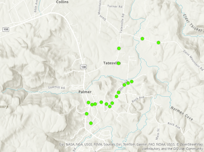
|
||||||||||
Damage Surveys
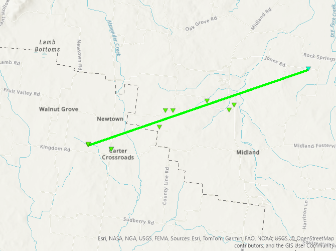
Public Information Statement
National Weather Service Nashville TN
121 PM CDT Sun Mar 16 2025

...NWS Damage Survey for March 15, 2025 Tornado Event Update #1...

On Saturday, March 15th, 2025, a line of showers and thunderstorms
moved through Middle TN. As the north-south line of storms crossed
over US Hwy 41A, it intensified causing a tornado to touch down
between US Hwy 41A and US 231. A couple hours later, a strong
mesocyclone moved out of Alabama and into Grundy county in southern
Middle TN. Strong straight line winds caused extensive damage in
Palmer, TN.

.EF-1/Christiana...

Rating:                 EF1
Estimated Peak Wind:    95 mph
Path Length /statute/:  4.49 miles
Path Width /maximum/:   300 yards
Fatalities:             0
Injuries:               0

Start Date:             03/15/2025
Start Time:             03:22 PM CDT
Start Location:         8 ESE Eagleville / Bedford County / TN
Start Lat/Lon:          35.6716 / -86.5328

End Date:               03/15/2025
End Time:               03:26 PM CDT
End Location:           9 NW Bell Buckle / Rutherford County / TN
End Lat/Lon:            35.6926 / -86.4573

Survey Summary:

The EF-1 tornado first touched down in far northwest Bedford
County near Carter Crossroads on Kingdom Road. At this location,
a half dozen outbuildings, storage buildings, and barns were
damaged or destroyed. The tornado continued east-northeast where
some minor damage occurred to homes along Longview Road. Garage
doors were blown in, fences were knocked down, outbuildings were
destroyed, and minor roof damage was observed. The tornado then
moved into far southwestern Rutherford County where trees were
downed on Threet Road as well as a few outbuildings damaged. More
tree damage was observed as the tornado approached Williams Road.
This area is no stranger to tornadoes as this tornado crossed the
path of the November 2018 Christiana tornado here. This path was
also just south of the May 2024 Christiana tornado as well.  This
tornado crossed Midland Road and finally lifted near Jones Road
before reaching Highway 231.


.Grundy County/Palmer Straight Line Wind Damage...

After an exhaustive survey of the damage near Palmer in Grundy County,
a NWS survey team has determined the damage in this area to be caused
by straight line winds with max wind speed of 95 mph. The width of the
damage path was determined to be over a mile wide, ruling out a tornado.
These very strong downsloping microburst winds blew straight into
Palmer causing many trees to be uprooted and snapped, along with some
structural damage in the area. All trees were fell in the generally
the same direction with no narrow tornado path found.

Special thanks to Matt Griffith of Grundy County EMA for his
assistance with the storm damage survey.

&&

EF Scale: The Enhanced Fujita Scale classifies tornadoes into the
following categories:

EF0.....65 to 85 mph
EF1.....86 to 110 mph
EF2.....111 to 135 mph
EF3.....136 to 165 mph
EF4.....166 to 200 mph
EF5.....>200 mph

NOTE:
The information in this statement is preliminary and subject to
change pending final review of the event and publication in
NWS Storm Data.


$$

Unger
Local Storm Reports
Preliminary Local Storm Report...Summary
National Weather Service Nashville TN
710 PM CDT Sun Mar 16 2025

..TIME...   ...EVENT...      ...CITY LOCATION...     ...LAT.LON...
..DATE...   ....MAG....      ..COUNTY LOCATION..ST.. ...SOURCE....
            ..REMARKS..

1230 PM     Flash Flood      3 E Waverly             36.09N 87.73W
03/15/2025                   Humphreys          TN   Emergency Mngr

            Some water over Highway 70 between Waverly
            and McEwen. Road was still passable.
            Otherwise, flooding of low lying areas near
            creeks and streams reported.

1231 PM     Flash Flood      1 S Goodlettsville      36.32N 86.70W
03/15/2025                   Davidson           TN   Public

            2 left lanes on I-65 NB just south of exit
            95 are underwater. Report from social media.

0157 PM     Flash Flood      3 NW Dickson            36.11N 87.42W
03/15/2025                   Dickson            TN   Public

            Videos on social media showing water over
            Walnut Grove Road in Dickson county.

0244 PM     Flash Flood      Loretto                 35.08N 87.44W
03/15/2025                   Lawrence           TN   Emergency Mngr

            Emergency Management reports US 43 is
            flooded at Loretto.

0245 PM     Flash Flood      1 N Lawrenceburg        35.26N 87.34W
03/15/2025                   Lawrence           TN   Emergency Mngr

            Emergency Manager reports street flooding in
            Lawrenceburg, TN.

0259 PM     Flash Flood      3 SE Portland           36.56N 86.48W
03/15/2025                   Sumner             TN   Trained Spotter

            The 1700 block of Old Gallatin Road SE of
            Portland TN is blocked due to flood waters.
            TSpotter.

0302 PM     Flash Flood      3 S Lawrenceburg        35.20N 87.34W
03/15/2025                   Lawrence           TN   Emergency Mngr

            Rambler's Edge RV Park is flooded south of
            Lawrenceburg TN.

0305 PM     Flash Flood      Portland                36.59N 86.52W
03/15/2025                   Sumner             TN   Emergency Mngr

            Old Gallatin Road in Portland is flooded.

0308 PM     Tstm Wnd Dmg     3 SW Cornersville       35.33N 86.88W
03/15/2025                   Marshall           TN   Public

            Relayed via social media, photo of tree
            snapped and power pole down on Blue Creek
            Road.

0318 PM     Tstm Wnd Dmg     6 SE Eagleville         35.68N 86.58W
03/15/2025                   Bedford            TN   Trained Spotter

            Possible structure damage near Kingdom road.
            TSpotter.

0319 PM     Tstm Wnd Dmg     2 NE Unionville         35.64N 86.57W
03/15/2025                   Bedford            TN   Trained Spotter

            Relayed from a TSpotter, damage to a
            powerline and a tree at the intersection of
            Longview Road and Pepper Hill.

0327 PM     Flash Flood      2 NW White House        36.48N 86.69W
03/15/2025                   Robertson          TN   Emergency Mngr

            Neighborhood roads near Pinson Lane are
            impassable.

0330 PM     Tstm Wnd Dmg     7 SSW Murfreesboro      35.76N 86.43W
03/15/2025                   Rutherford         TN   Public

            Trees were blown down at Webb Rd and
            Barfield-Crescent Rd. Time was estimated by
            radar.

0330 PM     Tstm Wnd Dmg     7 S Murfreesboro        35.75N 86.38W
03/15/2025                   Rutherford         TN   Public

            A privacy fence was blown down, partially
            blocking road along Rucker Rd near County
            Farm Rd.

0330 PM     Tstm Wnd Gst     5 N Shelbyville         35.56N 86.44W
03/15/2025  M61 MPH          Bedford            TN   AWOS


0345 PM     Tstm Wnd Dmg     4 W Bradyville          35.74N 86.23W
03/15/2025                   Rutherford         TN   Public

            Trees were blown down and blocking the road
            along Jacobs Hollow Rd near Bradyville Pike.
            Time estimated by radar.

0355 PM     Flash Flood      1 NW Westmoreland       36.57N 86.26W
03/15/2025                   Sumner             TN   Emergency Mngr

            Intersection of Hawkins Drive and Old
            Highway 31 E flooded.

0355 PM     Tstm Wnd Dmg     6 NE Unionville         35.68N 86.51W
03/15/2025                   Bedford            TN   Public

            Tree uprooted and damage to a metal building
            was reported near Christiana.

0358 PM     Tstm Wnd Dmg     8 NE Unionville         35.70N 86.49W
03/15/2025                   Rutherford         TN   Fire Dept/Rescue

            Rutherford County Fire working 2 reports of
            large trees blocking roadways in Christiana.
            6700blk Williams Rd, 4500blk Jones Rd.

0403 PM     Tstm Wnd Dmg     7 NE Bell Buckle        35.67N 86.28W
03/15/2025                   Rutherford         TN   Dept of Highways

            Debris blocking I-24 east at mile marker
            89.2 in Rutherford County. Tree across
            roadway with all eastbound lanes blocked.

0415 PM     Tstm Wnd Dmg     1 ESE Mcminnville       35.68N 85.77W
03/15/2025                   Warren             TN   Public

            Numerous downed trees were reported in the
            McMinnville area. Time estimate from radar.

0500 PM     Tstm Wnd Dmg     Palmer                  35.35N 85.57W
03/15/2025                   Grundy             TN   Emergency Mngr

            Trees down and structure damage to homes in
            Palmer. Time estimated by radar.

0530 PM     Tstm Wnd Dmg     1 E Jamestown           36.43N 84.92W
03/15/2025                   Fentress           TN   Emergency Mngr

            Several trees were blown down and minor
            structure damage was reported on the north
            side of Jamestown near Fairgrounds Rd.

0537 PM     Flash Flood      1 ENE Cumberland Furnac 36.27N 87.35W
03/15/2025                   Dickson            TN   Public

            Portions of Stark Rd covered in water and
            impassible in spots.

0537 PM     Flash Flood      1 ENE Cumberland Furnac 36.27N 87.35W
03/15/2025                   Dickson            TN   Public

            Portions of Stark Rd covered in water and
            impassible in spots.

0542 PM     Flash Flood      2 S Cookeville          36.12N 85.51W
03/15/2025                   Putnam             TN   Public

            Water covering roads at South Jefferson and
            Sliger Rd.

0543 PM     Flash Flood      1 NNE Baxter            36.17N 85.63W
03/15/2025                   Putnam             TN   Emergency Mngr

            Water covering road at 1286 Main St. in
            Baxter.

0549 PM     Flash Flood      2 WSW Mount Pleasant    35.55N 87.22W
03/15/2025                   Maury              TN   Public

            Water was covering the road in several spots
            along Highway 43 between Columbia and
            Lawrenceburg.

0551 PM     Flash Flood      1 ENE Berry Hill        36.12N 86.75W
03/15/2025                   Davidson           TN   Public

            Deep water covering the road at I-440 and
            Nolensville Pike.

0613 PM     Flash Flood      7 SSW Clarkrange        36.09N 85.06W
03/15/2025                   Cumberland         TN   Public

            Water flooding Highway 127N between
            Crossville and Clarkrange.

0802 PM     Flash Flood      3 N West Point          35.17N 87.54W
03/15/2025                   Lawrence           TN   Emergency Mngr

            Wisdom Rd near West Point completely washed
            out.

1115 PM     Flood            Auburntown              35.95N 86.09W
03/15/2025                   Cannon             TN   Trained Spotter

            Hurricane Creek Rd. impassable due to
            flooding.

1150 PM     Non-Tstm Wnd Dmg Livingston              36.39N 85.32W
03/15/2025                   Overton            TN   Emergency Mngr

            Several trees down across the county due to
            non thunderstorm winds.

1155 PM     Non-Tstm Wnd Dmg 9 N Livingston          36.52N 85.32W
03/15/2025                   Overton            TN   Public

            Pictures from social media show a large
            amount of roofing material blown off of a
            church.

0119 AM     Flood            Cookeville              36.16N 85.51W
03/16/2025                   Putnam             TN   Emergency Mngr

            1343 Whiteaker Springs Rd. quickly becoming
            covered in water.

0119 AM     Flood            Cookeville              36.16N 85.51W
03/16/2025                   Putnam             TN   Emergency Mngr

            1343 Whiteaker Springs Rd. quickly becoming
            covered in water.


&&

$$
 |
Media use of NWS Web News Stories is encouraged! Please acknowledge the NWS as the source of any news information accessed from this site. |
|