Overview
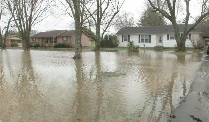
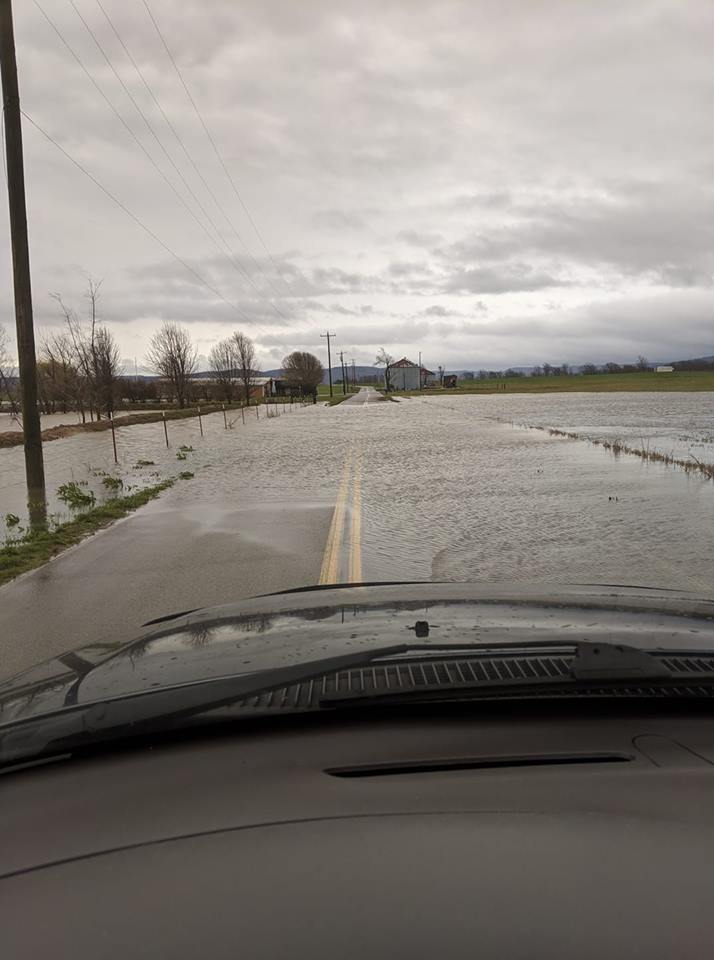
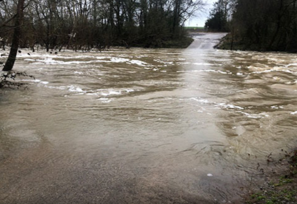
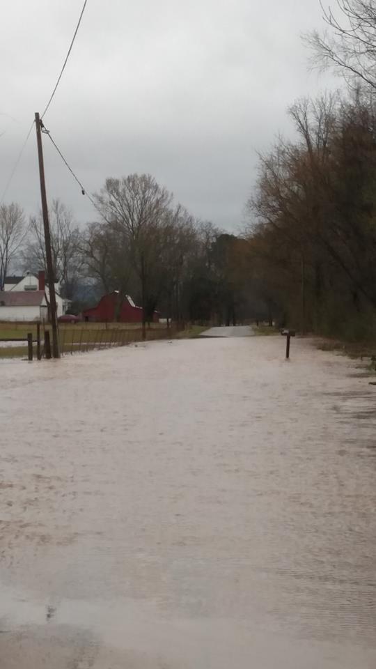
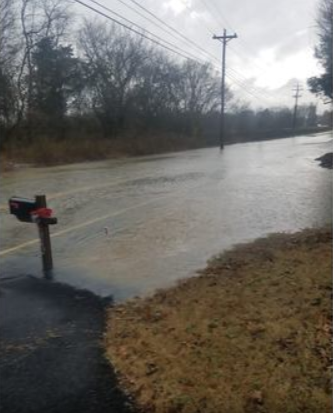
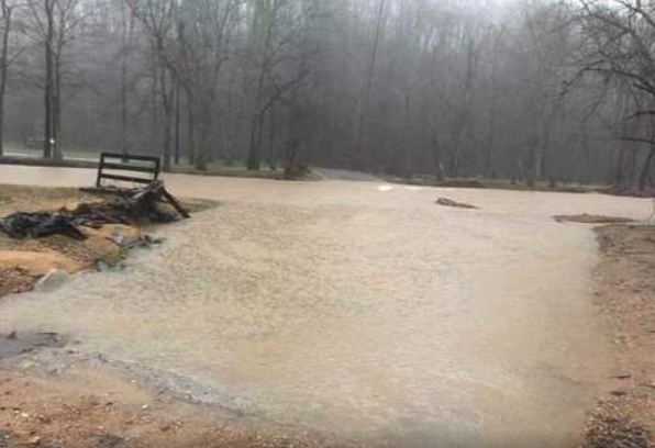
A stationary frontal boundary stalled over or near the Tennessee Valley for nearly a week in mid to late February 2019. Persistent southwest flow aloft brought copious amounts of Gulf of America moisture northward and interacted with this boundary for many days, causing a prolonged period of heavy rain and flooding throughout Middle Tennessee from Tuesday, February 19 through early Sunday, February 24. Due to the heavy rainfall that had already fallen earlier in the month along with the already unusually wet winter season so far, widespread flash flooding and river flooding resulted, with dozens of water rescues being conducted and numerous homes and businesses flooded. In addition, this heavy rainfall set new monthly rainfall records for the month February at many locations including Nashville and Crossville, both of which saw over a foot of rain. By the end of the month, nearly the entire state of Tennessee had received between 10" and 20" of rain in February 2019.

Flooding
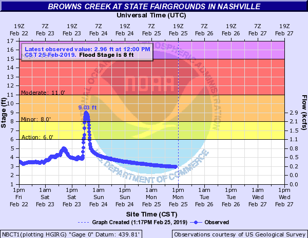
Hydrographs - Browns Creek
 |
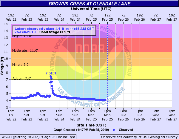 |
| at State Fairgrounds in Nashville | at Glendale Lane |
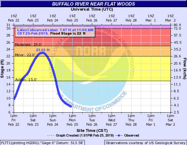
Hydrographs - Buffalo River
 |
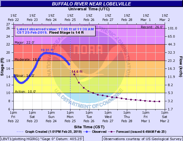 |
| near Flat Woods | near Lobelville |
Hydrographs - Collins River
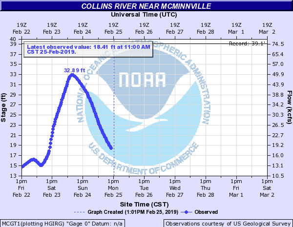 |
| near McMinnville |
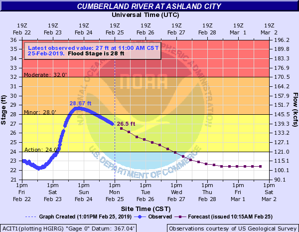
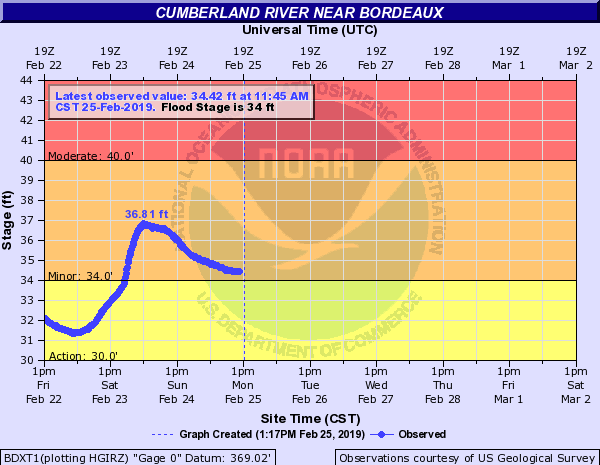
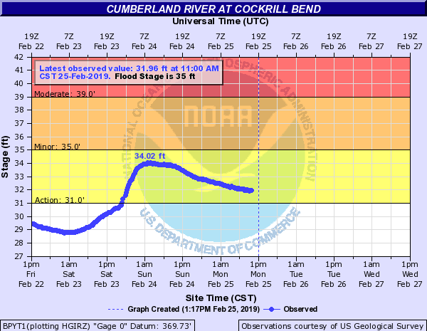
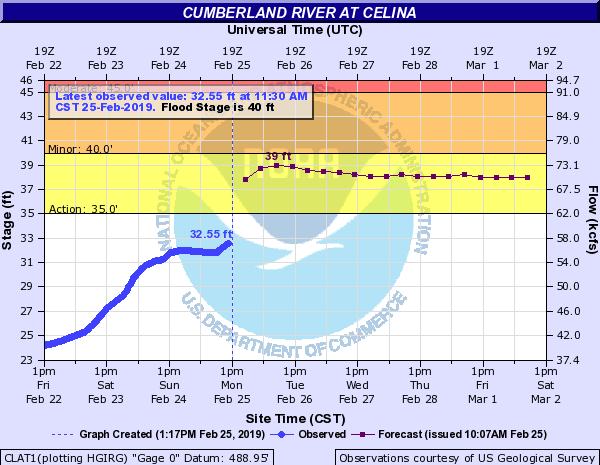
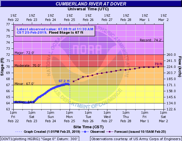
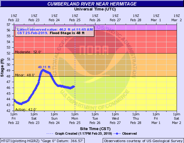
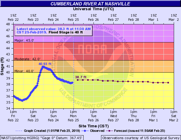
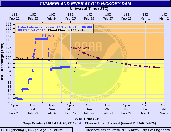
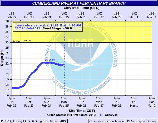
Hydrographs - Cumberland River
 |
 |
 |
 |
| at Ashland City | near Bordeaux | at Cockrill Bend | at Cheatham Lock and Dam |
 |
 |
 |
 |
| at Clarksville | at Celina | at Dover | at Edenwold |
 |
 |
 |
 |
| near Hermitage | at Nashville | at Old Hickory Dam | at Omohundro |
 |
 |
| at Penitentiary Branch | near Penington Bend |
Hydrographs - Dry Creek
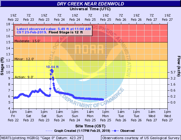 |
| near Edenwold |
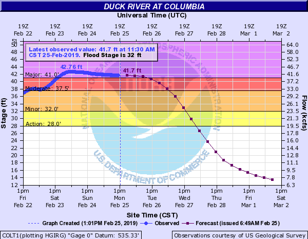
Hydrographs - Duck River
 |
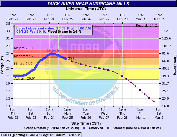 |
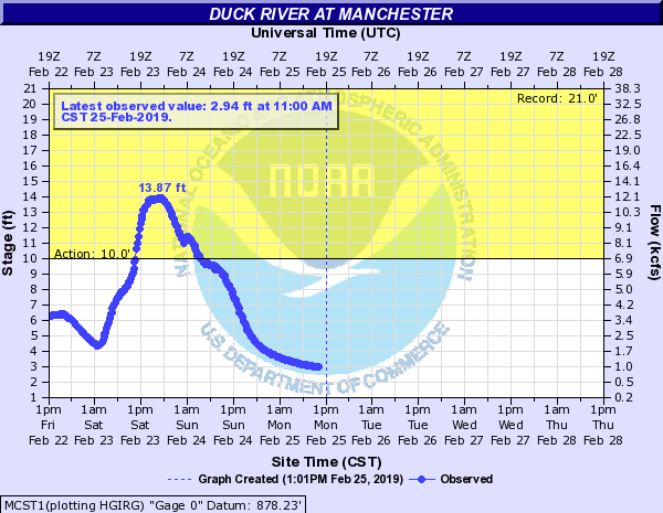 |
| at Columbia | near Hurricane Mills | at Manchester |
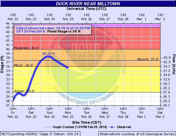 |
 |
| near Milltown | at Normandy Dam |
Hydrographs - Elk River
 |
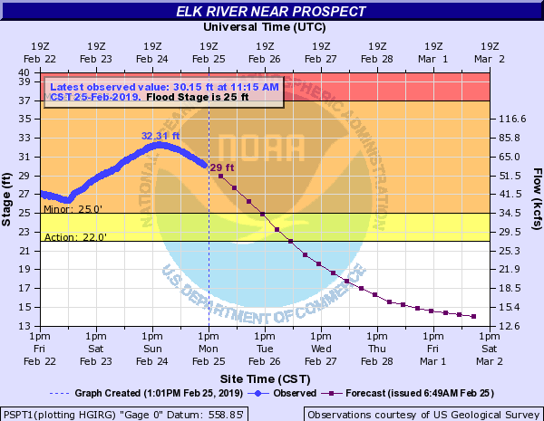 |
| near Pelham | near Prospect |
Hydrographs - Harpeth River
 |
 |
 |
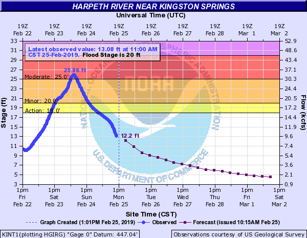 |
| at Bellevue | at Franklin | below Franklin | near Kingston Springs |
Hydrographs - Mansker Creek
 |
| near Millersville |
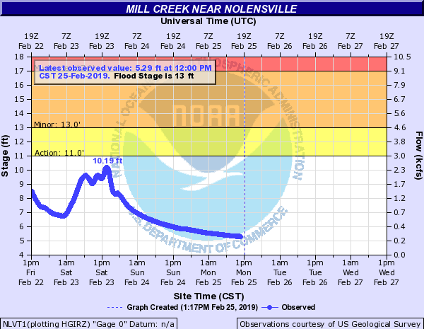
Hydrographs - Mill Creek
 |
 |
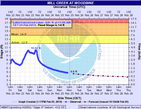 |
| at Antioch | near Nolensville | at Woodbine |
Hydrographs - Piney River
 |
| near Vernon |
Hydrographs - Red River
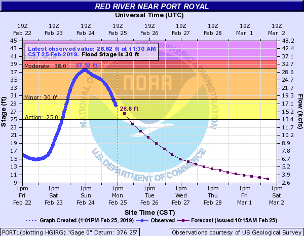 |
| near Port Royal |
Hydrographs - Richland Creek
 |
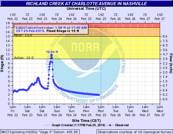 |
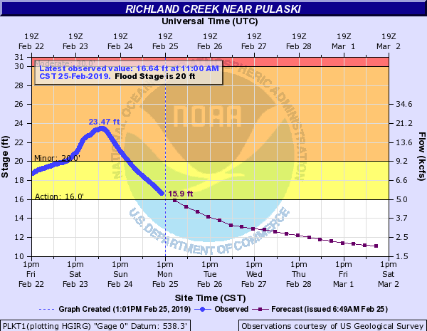 |
| near Belle Meade | at Charlotte Avenue in Nashville | near Pulaski |
Hydrographs - Sevenmile Creek
 |
| at Blackman Road |
Hydrographs - Shoal Creek
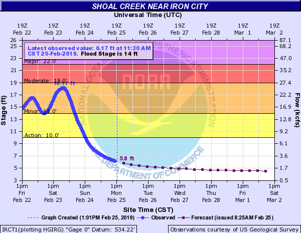 |
| near Iron City |
Hydrographs - Stones Creek
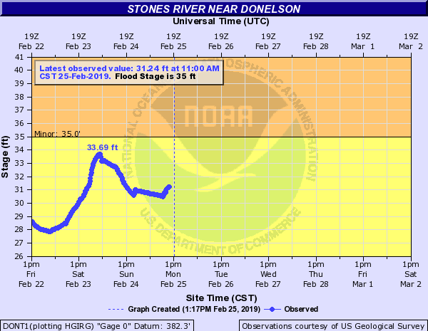 |
 |
| near Donelson | below J Percy Priest Dam |
Hydrographs - Sycamore Creek
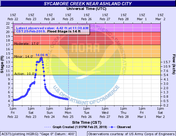 |
| near Ashland City |
Hydrographs - TN River
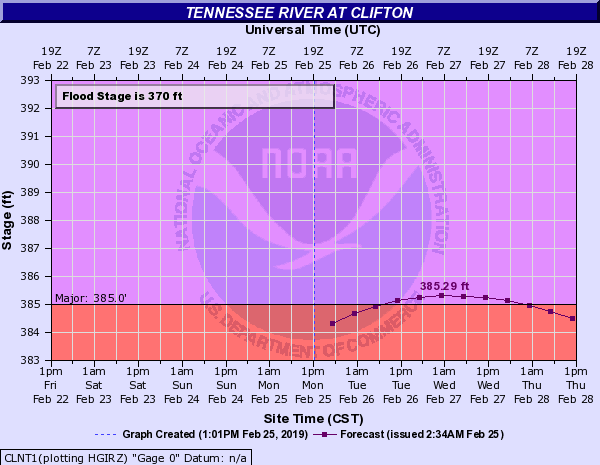 |
 |
 |
 |
| at Clifton | at Johnsonville | at Perryville | at Savannah |
Hydrographs - W. Fork Stones River
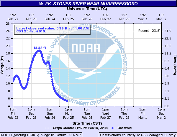 |
| near Murfeesboro |
Hydrographs - Wartrace Creek
 |
| at Wartrace |
Hydrographs - Whites Creek
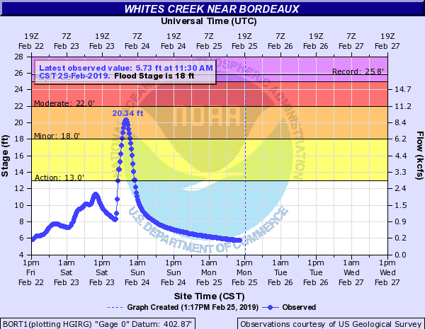 |
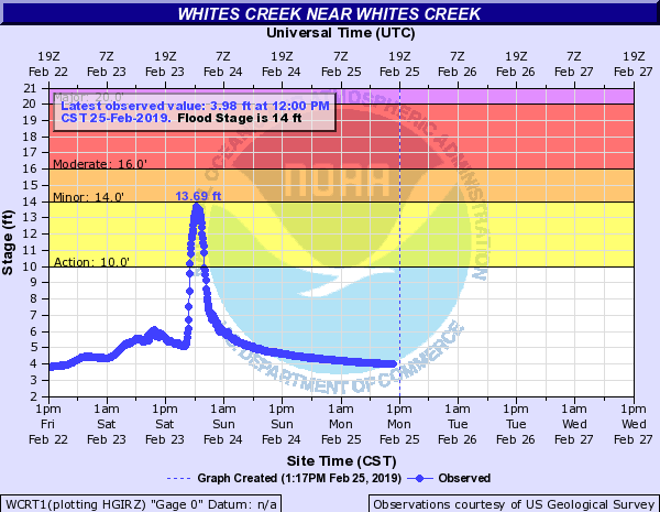 |
| near Bordeaux | Whites Creek |
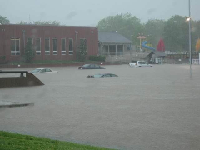
Photos & Video
 |
 |
 |
| Brentwood YMCA Parking Lot (Facebook) |
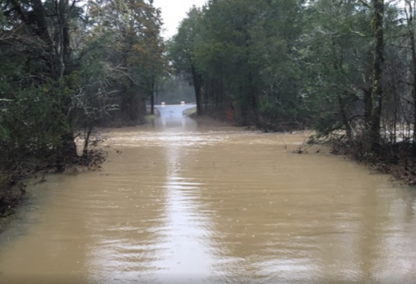
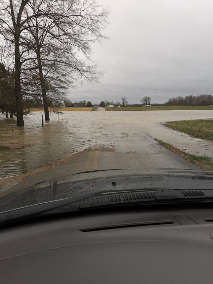
Factory Creek Road in Giles County (Facebook) |
Cedars of Lebanon (Twitter) |
 |
 |
 |
 |
| Gossburg Road at Sutton Branch and Garrison Fork Creeks in Beechgrove (Facebook) |
Hickory Grove Road in Coffee County (Facebook) |
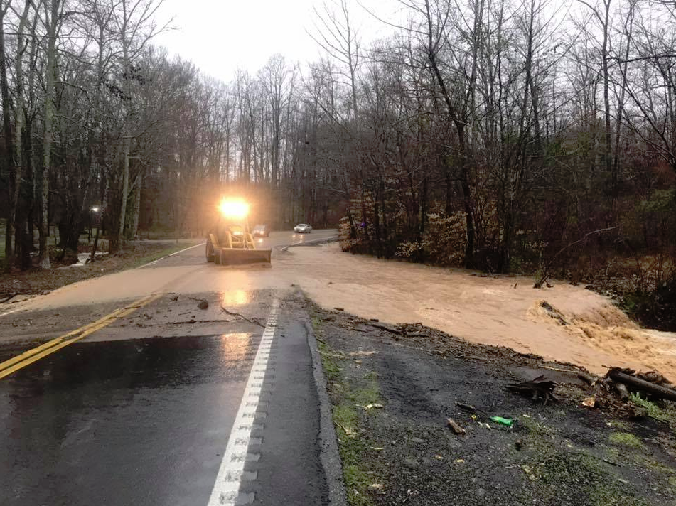
Near Main Street on Iron City Road in Lawrence County (Facebook) |
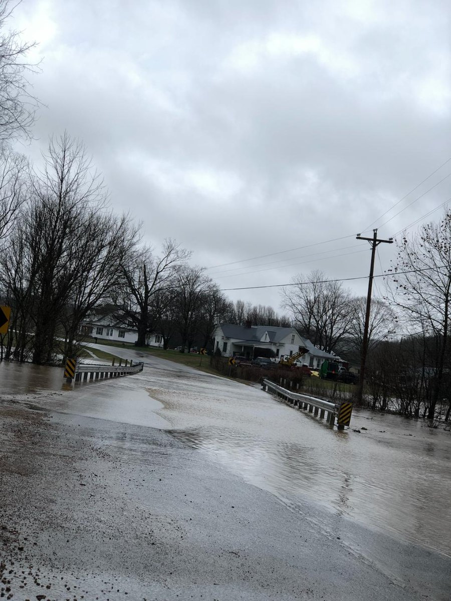
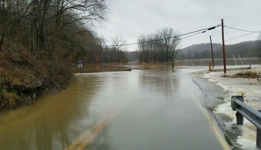
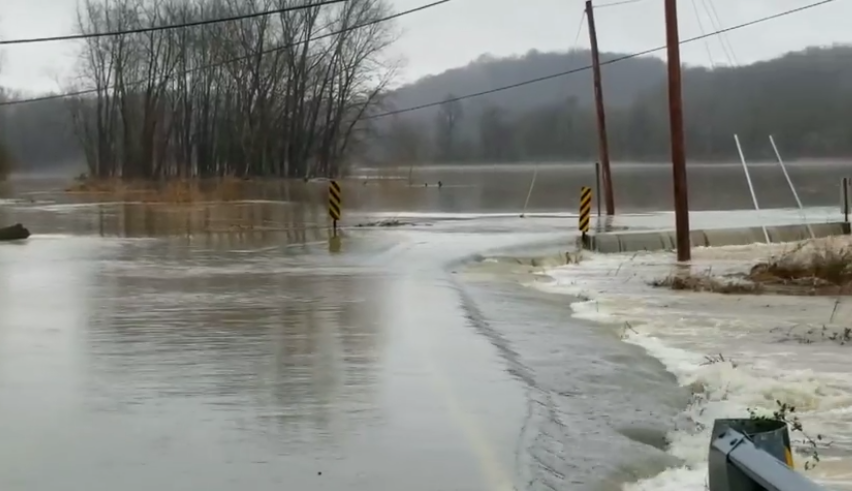
Lockertsville Road at Harristown Road in Cheatham County (Facebook) |
 |
 |
 |
| Lockertsville Road at Harristown Road in Cheatham County (Facebook) |
Flooding in Murfreesboro (Facebook) |
Rock Road in Coffee County (Facebook) |
 |
 |
 |
 |
| Flooding in Rutherford County (Facebook) |
Stephenson Road in Hillsboro (Facebook) |
Sulphur Springs Road in Murfreesboro (Facebook) |
Flooding in Tennessee City (Facebook) |
Top 10 Wettest Februarys and All-Time Records
Public Information Statement
National Weather Service Nashville TN
740 AM CST Wed Feb 27 2019

...February 2019 now wettest February on record for Nashville and
Crossville...

...February 2019 also one of the wettest months of all time at
Nashville and Crossville...

Top 10 Wettest Februarys in Nashville

Rank           Year            Monthly Total Rainfall (inches)
1*             2019*                     13.47*
2              1880                      12.37
3              1890                      10.95
4              2018                      10.91
5              1956                      10.31
6              1989                       9.36
7              1874                       9.23
8              1962                       9.07
9              1939                       8.87
10             1894                       8.65

*through February 27, 2019

Top 10 Wettest Februarys in Crossville

Rank           Year            Monthly Total Rainfall (inches)
1*             2019*                     12.35*
2              2003                      10.52
3              2018                      10.48
4              1962                       9.14
5              1956                       9.07
6              2016                       8.94
7              1994                       7.44
8              1957                       7.02
9              1991                       6.96
10             1975                       6.89

*through February 27, 2019

Top 10 Wettest Months of All Time in Nashville

Rank        Month/Year         Monthly Total Rainfall (inches)
1            May 2010                    16.43
2            Jan 1937                    14.75
3            Jan 1882                    14.51
4            Jan 1950                    13.92
5            Dec 1978                    13.63
6            Dec 1926                    13.53
7*           Feb 2019*                   13.47*
8            Feb 1880                    12.37
9            Mar 1975                    12.35
10           Jan 1913                    12.30

*through February 27, 2019

Top 10 Wettest Months of All Time in Crossville

Rank        Month/Year         Monthly Total Rainfall (inches)
1            Mar 1975                    15.34
2            Jun 1998                    14.15
3            Dec 1990                    12.75
4*           Feb 2019*                   12.35*
5            Jul 1967                    11.95
6            Mar 1980                    11.94
7            Jul 1956                    11.93
8            Mar 1973                    11.71
9            Jul 1979                    11.70
10           May 2003                    11.68

*through February 27, 2019

$$

Shamburger
Local Storm Reports
PRELIMINARY LOCAL STORM REPORT...SUMMARY
NATIONAL WEATHER SERVICE NASHVILLE TN
557 AM CST THU FEB 21 2019
..TIME... ...EVENT... ...CITY LOCATION... ...LAT.LON...
..DATE... ....MAG.... ..COUNTY LOCATION..ST.. ...SOURCE....
..REMARKS..
0615 AM FLOOD 1 N CHARLOTTE 36.20N 87.35W
02/20/2019 DICKSON TN MEDIA
ROAD CLOSED DUE TO FLOODING IN CHARLOTTE AT THE
INTERSECTION OF HAFNER ROAD AND HWY 48 N.
0635 AM FLOOD NOLENSVILLE 35.95N 86.65W
02/20/2019 WILLIAMSON TN SOCIAL MEDIA
PORTIONS OF KIDD ROAD REPORTEDLY UNDERWATER
0725 AM FLASH FLOOD FRANKLIN 35.93N 86.84W
02/20/2019 WILLIAMSON TN MEDIA
REPORT OF ROAD CLOSURE DUE TO HIGH WATER AND FLOODING
CHESTNUT LANE AND MAPLE DRIVE.
0746 AM FLASH FLOOD 3 SSE LEBANON 36.17N 86.30W
02/20/2019 WILSON TN EMERGENCY MNGR
RESIDENTS OF TIMERLINE CAMPGROUND EVACUATED DUE TO
SINKING CREEK OUT OF ITS BANK.
0816 AM FLASH FLOOD SPRING HILL 35.74N 86.92W
02/20/2019 MAURY TN EMERGENCY MNGR
REPORTS OF ROAD CLOSED DUE TO FLASH FLOODING, OLD
KEYDREN ROAD BETWEEN DUPLEX AND KEIDRON ROAD.
0817 AM FLASH FLOOD 2 NNW LIVINGSTON 36.42N 85.34W
02/20/2019 OVERTON TN EMERGENCY MNGR
REPORTS OF ROADS CLOSED IN OVERTON COUNTY. TOWER HILL,
BRADFORD HICKS DRIVE, NORTH OAK STREET.
0850 AM FLASH FLOOD 6 S MURFREESBORO 35.77N 86.37W
02/20/2019 RUTHERFORD TN MESONET
REPORT OF THE FOLLOWING ROADS BEING CLOSED IN
RUTHERFORD COUNTY DUE TO FLOODING. STONES RIVER SLAB,
COUNTY FARM AT ELAM ROAD, VAUGHT AT CRIPPLE CREEK,
KEDRON CHURCH, AND ELAM SLAB.
0905 AM FLASH FLOOD 2 WNW NASHBORO VILLAGE 36.11N 86.67W
02/20/2019 DAVIDSON TN EMERGENCY MNGR
REPORT OF KNAPP BLVD NEAR DONALDSON PIKE CLOSED DUE TO
FLOODING.
0926 AM FLASH FLOOD MURFREESBORO 35.85N 86.39W
02/20/2019 RUTHERFORD TN AMATEUR RADIO
MORE ROAD CLOSURES DUE TO FLOODING IN RUTHERFORD
COUNTY: JAMESTOWN HIGHWAY NEAR MEMORIAL GARDEN DRIVE.
0928 AM FLASH FLOOD LEBANON 36.21N 86.32W
02/20/2019 WILSON TN EMERGENCY MNGR
ALSUP MILL AT BALDY FORD CLOSED DUE TO FLOODING.
0951 AM FLASH FLOOD FRANKLIN 35.93N 86.84W
02/20/2019 WILLIAMSON TN EMERGENCY MNGR
NUMEROUS ROADS WERE FLOODED AND CLOSED ACROSS
WILLIAMSON COUNTY INCLUDING ARNO ROAD...BEECHCROFT
ROAD...LEWISBURG PIKE...PEYTONSVILLE ROAD...YORK
ROAD...NORTH CHAPEL ROAD...BLAZER ROAD...TRINITY
ROAD...OLD NATCHEZ TRACE...AND MANY OTHERS.
1000 AM HEAVY RAIN BELLEVUE 36.06N 86.94W
02/20/2019 M2.05 INCH DAVIDSON TN AMATEUR RADIO
MEASURED REPORT FROM A HAM OPERATOR OF 2.05" IN 24
HOURS, AND 1.28" SINCE MIDNIGHT.
1000 AM FLASH FLOOD LEBANON 36.21N 86.32W
02/20/2019 WILSON TN EMERGENCY MNGR
SEVERAL ROADS WERE FLOODED AND CLOSED ACROSS WILSON
COUNTY INCLUDING STEWARTS FERRY PIKE...ALSUP MILL AT
BALDY FORD...AND BLUEBIRD ROAD.
1010 AM FLASH FLOOD NOLENSVILLE 35.95N 86.65W
02/20/2019 WILLIAMSON TN TRAINED SPOTTER
BRITTAIN LANE CLOSED DUE TO FLOODING AT THE MILL CREEK
BRIDGE.
1015 AM FLASH FLOOD LA VERGNE 36.00N 86.57W
02/20/2019 RUTHERFORD TN AMATEUR RADIO
REPORT OF ROAD CLOSED DUE TO FLOODING AT APPLE STREET
AND OLD HICKORY HIGHWAY.
1033 AM FLASH FLOOD MURFREESBORO 35.85N 86.39W
02/20/2019 RUTHERFORD TN LAW ENFORCEMENT
MORE ROAD CLOSURES: 4300 BLOCK ELAM ROAD, WEST
JEFFERSON PIKE AND POWELLS CHURCH ROAD, BLACKMAN ROAD AT
BASS ROAD, AND SULPHER SPRING ROAD AT SHACKLETT ROAD.
1033 AM FLASH FLOOD MURFREESBORO 35.85N 86.39W
02/20/2019 RUTHERFORD TN AMATEUR RADIO
SULPHUR SPRING ROAD BESIDES LEANNE CHURCH OF CHRIST IS
FLOODED.
1130 AM FLASH FLOOD NASHVILLE 36.17N 86.78W
02/20/2019 DAVIDSON TN AMATEUR RADIO
MILL CREEK OVER ITS BANK AND SPILLING INTO LOW LYING
AREAS BRILEY PARKWAY AND MILL CREEK OVERPASS NEAR I-24
1135 AM FLASH FLOOD COOKEVILLE 36.16N 85.51W
02/20/2019 PUTNAM TN EMERGENCY MNGR
1 FOOT OF WATER OVER INTERSECTION OF MOSS AND DITTY
ROADS
1150 AM FLASH FLOOD NASHVILLE 36.17N 86.78W
02/20/2019 DAVIDSON TN EMERGENCY MNGR
SEVERAL ROADS WERE FLOODED AND CLOSED ACROSS DAVIDSON
COUNTY INCLUDING CULBERTSON ROAD NEAR
NOLENSVILLE...NOLENSVILLE ROAD AT BLUFF ROAD...GRANADA
AVENUE AT APEX STREET...GLENROSE AVE AT OLD GLENROSE
AVE...NEWSOM STATION ROAD AT MERRYMOUNT DRIVE...AND THE
AREA AROUND THE ELLINGTON AG CENTER BARNS AND ARENA.
1200 PM FLASH FLOOD SHELBYVILLE 35.49N 86.45W
02/20/2019 BEDFORD TN EMERGENCY MNGR
NUMEROUS ROADS WERE FLOODED AND CLOSED ACROSS BEDFORD
COUNTY INCLUDING MULLINS MILL ROAD...BUGSCUFFLE
ROAD...MIDLAND ROAD AT PEACOCK LANE...HAPPY VALLEY
ROAD...SOUTH VALLEY ROAD AT NARROWS AND WOODLAND
DRIVE...EL BETHEL ROAD AT SHAW ROAD...ARNOLD ROAD AT
FAIRFIELD PIKE...AIRPORT ROAD...HIGGINS ROAD...MILLHOUSE
ROAD...HURRICANE GROVE ROAD...WHITESIDE HILL ROAD AT
HIGHWAY 130...CATHY ROAD...AND HALLS MILL ROAD AT VIRGIL
CROWELL ROAD.
1200 PM FLASH FLOOD ALTAMONT 35.43N 85.73W
02/20/2019 GRUNDY TN EMERGENCY MNGR
SEVERAL ROADS WERE FLOODED ACROSS GRUNDY COUNTY
INCLUDING DOGTOWN ROAD...HIGHWAY 50 IN PELHAM...HIGHWAY
108...AND LEE HARGIS ROAD.
1200 PM FLASH FLOOD MANCHESTER 35.47N 86.08W
02/20/2019 COFFEE TN DEPT OF HIGHWAYS
SEVERAL ROADS WERE FLOODED ACROSS COFFEE COUNTY
INCLUDING SKINNER FLAT ROAD...LUMLEY STAND
ROAD...STEPHENSON ROAD...HICKORY GROVE ROAD...AND ROCK
ROAD.
1245 PM FLASH FLOOD 3 NE CENTERTOWN 35.76N 85.88W
02/20/2019 WARREN TN AMATEUR RADIO
KNIGHT ROAD IMPASSABLE AT CHARLES CREEK
0100 PM FLASH FLOOD MONTEREY 36.13N 85.24W
02/20/2019 PUTNAM TN SOCIAL MEDIA
SEVERAL ROADS WERE FLOODED ACROSS PUTNAM COUNTY
INCLUDING LEE SEMINARY ROAD AND BENNETT ROAD NEAR
COOKEVILLE...AND COMMERCIAL AVENUE IN MONTEREY.
0130 PM FLASH FLOOD WOODBURY 35.82N 86.07W
02/20/2019 CANNON TN EMERGENCY MNGR
NUMEROUS ROADS WERE FLOODED AND CLOSED ACROSS CANNON
COUNTY INCLUDING MCFERRIN STREET...MEADOWBROOK
DRIVE...GREENBRIAR DRIVE...WILMOUTH CREEK...BULLPEN
CREEK ROAD...RIVER ROAD...BRIDGE ROAD...AND BUSH ROAD.
0145 PM FLASH FLOOD GAINESBORO 36.36N 85.65W
02/20/2019 JACKSON TN 911 CALL CENTER
NUMEROUS ROADS WERE FLOODED AND CLOSED ACROSS JACKSON
COUNTY INCLUDING GLADDICE HIGHWAY...BLACKBURN FORK
ROAD...FORT BLOUNT FERRY ROAD NEAR GRANVILLE
HIGHWAY...DODSON BRANCH HIGHWAY NEAR BLACKBURN FORK
ROAD...ROARING RIVER ROAD...SPRING CREEK ROAD...AARON
BRANCH ROAD...AND OVERTON ROAD.
0430 PM FLASH FLOOD CROSSVILLE 35.95N 85.04W
02/20/2019 CUMBERLAND TN EMERGENCY MNGR
SEVERAL ROADS WERE FLOODED AND CLOSED ACROSS CUMBERLAND
COUNTY INCLUDING HIGHWAY 70 NORTH AT MAYLAND
MARKET...POMONA ROAD...AND CRESTON ROAD.
0430 PM FLASH FLOOD LIVINGSTON 36.39N 85.33W
02/20/2019 OVERTON TN EMERGENCY MNGR
OVERTON/PICKETT 911 REPORTED SOME HOMES AND BUSINESSES
IN LIVINGSTON WERE FLOODED. ROADS WERE ALSO FLOODED AND
CLOSED ACROSS OVERTON COUNTY INCLUDING THE HWY 111
BYPASS SOUTHBOUND...HIGHWAY 52...CEDAR CHAPEL
ROAD...SHILOH ROAD...COLUMBIA HILL ROAD...AND CEDAR
SPRINGS ROAD.
&&
EVENT NUMBER OHX1900111 OHX1900112 OHX1900113 OHX1900114 OHX1900115
OHX1900116 OHX1900118 OHX1900117 OHX1900119 OHX1900120 OHX1900137
OHX1900121 OHX1900138 OHX1900122 OHX1900123 OHX1900124 OHX1900125
OHX1900128 OHX1900127 OHX1900139 OHX1900129 OHX1900130 OHX1900131
OHX1900126 OHX1900132 OHX1900133 OHX1900134 OHX1900135 OHX1900136
$$
SHAMBURGER
PRELIMINARY LOCAL STORM REPORT...SUMMARY
NATIONAL WEATHER SERVICE NASHVILLE TN
742 AM CST SUN FEB 24 2019
..TIME... ...EVENT... ...CITY LOCATION... ...LAT.LON...
..DATE... ....MAG.... ..COUNTY LOCATION..ST.. ...SOURCE....
..REMARKS..
0209 AM FLASH FLOOD 5 WSW SUMMERTOWN 35.39N 87.39W
02/23/2019 LAWRENCE TN EMERGENCY MNGR
LAWRENCE COUNTY EMA REPORTS 95 PERCENT OF LOW WATER
BRIDGES IN LAWRENCE COUNTY IMPASSABLE. WATERFORK ROAD
NEAR HENRYVILLE COMMUNITY UNDERWATER. ALL CREEKS RISING.
0209 AM FLASH FLOOD PULASKI 35.20N 87.03W
02/23/2019 GILES TN LAW ENFORCEMENT
TENNESSEE HIGHWAY PATROL REPORTS PARTS OF HIGHWAY 31 IN
GILES COUNTY UNDERWATER
0248 AM FLASH FLOOD 3 N IRON CITY 35.06N 87.58W
02/23/2019 LAWRENCE TN EMERGENCY MNGR
CORRECTED LOCATION. WATER OVER TN HIGHWAY 242 BETWEEN
MILE MARKERS 3 AND 4 APPX 3 MILES NORTH OF IRON CITY.
0533 AM FLASH FLOOD 7 WSW ELKTON 35.03N 87.01W
02/23/2019 GILES TN BROADCAST MEDIA
MEDIA REPORTED GILES COUNTY FIRE AND RESCUE RESCUED A
WOMAN...3 CHILDREN...AND SEVERAL DOGS FROM A HOME
SURROUNDED BY WATER ON ALF HARRIS ROAD IN PROSPECT.
0541 AM FLASH FLOOD 9 W LINDEN 35.60N 88.00W
02/23/2019 PERRY TN 911 CALL CENTER
NUMEROUS ROADS CLOSED, ESPECIALLY ACROSS THE NORTHERN
AND WESTERN PORTION OF THE COUNTY...INCLUDING CYPRESS
CREEK RD AND RUSSELL CREEK RD.
0608 AM FLASH FLOOD 10 W LINDEN 35.60N 88.01W
02/23/2019 PERRY TN BROADCAST MEDIA
MEDIA REPORTED THAT A VEHICLE BECAME TRAPPED IN FLOOD
WATERS ON CYPRESS CREEK ROAD. DRIVER GOT OUT SAFELY.
0700 AM FLASH FLOOD COLUMBIA 35.62N 87.05W
02/23/2019 MAURY TN EMERGENCY MNGR
RIVERSIDE DRIVE IN COLUMBIA WAS REPORTEDLY FLOODED AND
CLOSED
0704 AM FLASH FLOOD 5 N LEWISBURG 35.52N 86.77W
02/23/2019 MARSHALL TN MEDIA
WATER IS THREATENING HOMES BETWEEN LEWISBURG AND CHAPEL
HILL DUE TO ROCK CREEK AND DUCK RIVER FLOODING. ANOTHER
10 TO 15 ROADS ARE IMPASSABLE, WITH ANOTHER 15 TO 20
ROADS HAVING WATER OR DEBRIS ON THEM.
0721 AM FLASH FLOOD 4 W ALTAMONT 35.44N 85.80W
02/23/2019 GRUNDY TN SOCIAL MEDIA
PORTION OF FIRETOWER RD WASHED OUT VIA SOCIAL MEDIA
PHOTOS.
0743 AM FLASH FLOOD 4 NNW MURFREESBORO 35.90N 86.42W
02/23/2019 RUTHERFORD TN MEDIA
DRIVER WAS RESCUED FROM VEHICLE AFTER DRIVING THROUGH
BARRICADE ON SULFUR SPRINGS RD.
0745 AM FLASH FLOOD ETHRIDGE 35.31N 87.30W
02/23/2019 LAWRENCE TN MEDIA
WATER OVER GWINN RD AT LITTLE SHOAL CREEK.
0812 AM FLASH FLOOD 7 ESE MANCHESTER 35.43N 85.96W
02/23/2019 COFFEE TN MEDIA
WATER RESCUE IN 1500 BLOCK OF HILLSBORO VIOLA RD NEAR
HWY 127.
0812 AM FLASH FLOOD 4 E HOHENWALD 35.54N 87.50W
02/23/2019 LEWIS TN AMATEUR RADIO
SEVERAL ROAD CLOSURES DUE TO FLASH FLOODING IN LEWIS
COUNTY. RACKLEY RD, 1285 BLOCK DARBYTOWN RD, 1500 BLOCK
SIEBER RIDGE RD, TEXAS BOTTOMS NEAR SINCKLER RD, AND
NAPIER RD AT MURPHY BRIDGE.
0848 AM FLASH FLOOD MANCHESTER 35.47N 86.08W
02/23/2019 COFFEE TN LAW ENFORCEMENT
NUMEROUS ROADS FLOODED AND CLOSED ACROSS COFFEE COUNTY
INCLUDING SKINNER FLAT ROAD...ESTERN LANE...AND SCOTT
SWINNEY DRIVE.
0912 AM FLASH FLOOD 7 W MURFREESBORO 35.86N 86.52W
02/23/2019 RUTHERFORD TN FIRE DEPT/RESCUE
ROADS TAKING ON WATER IN THE ROYAL GLEN SUBDIVISION AND
THE 4600 BLOCK OF SHORES ROAD.
0937 AM FLASH FLOOD 3 SE CHERRY HILLS 36.05N 86.57W
02/23/2019 DAVIDSON TN FIRE DEPT/RESCUE
WATER RESCUE UNDERWAY AT FOUR CORNERS MARINA. DOCKS AND
RAMPS REPORTED UNDERWATER WITH MULTIPLE PEOPLE STUCK ON
BOATS AS WATER CONTINUES TO RISE. LOCATION IS PERCY
PRIEST LAKE.
1000 AM FLASH FLOOD 7 ESE MANCHESTER 35.41N 85.97W
02/23/2019 COFFEE TN BROADCAST MEDIA
WATER RESCUE OF FAMILY IN THE HILLSBORO AREA. 34 ROADS
REPORTEDLY IMPASSABLE ACROSS THE COUNTY.
1000 AM FLASH FLOOD FRANKLIN 35.93N 86.84W
02/23/2019 WILLIAMSON TN EMERGENCY MNGR
SEVERAL ROADS FLOODED AND CLOSED ACROSS THE COUNTY
INCLUDING 3RD AVE NEAR CENTENNIAL...WEST HARPETH AT
HUNTER ROAD...BOYD MILLE PIKE...FLOYD ROAD...OLD NATCHEZ
TRACE...2089 KIDD ROAD...2084 WILSON PIKE...CLOVERCROFT
ROAD...AND MORAN ROAD.
1004 AM FLASH FLOOD COLUMBIA 35.62N 87.05W
02/23/2019 MAURY TN EMERGENCY MNGR
APPROXIMATELY 15 ROADS FLOODED AND CLOSED ACROSS THE
COUNTY AND NUMEROUS OTHERS WITH HIGH WATER
1016 AM FLASH FLOOD 1 W WOODBURY 35.82N 86.10W
02/23/2019 CANNON TN SOCIAL MEDIA
WATER FLOWING OVER ROADWAY AT THE EAST FORK STONES
RIVER BEHIND THE ARTS CENTER OF CANNON COUNTY.
1021 AM FLASH FLOOD 1 S SHELBYVILLE 35.47N 86.44W
02/23/2019 BEDFORD TN TRAINED SPOTTER
WATER FLOWING OVER ROADWAY BETWEEN DUCK RIVER BRIDGE
AND SULPHUR SPRINGS RD ON TN-130.
1030 AM FLASH FLOOD 3 N BON AQUA 36.00N 87.33W
02/23/2019 DICKSON TN EMERGENCY MNGR
SEVERAL SECONDARY ROADS FLOODED AND IMPASSABLE ACROSS
SOUTHERN DICKSON COUNTY
1036 AM FLASH FLOOD 5 SW MURFREESBORO 35.80N 86.46W
02/23/2019 RUTHERFORD TN MEDIA
KIMBRO WOODS SUBDIVISION EXPERIENCING FLOODING FROM
RAIN DURING THE MORNING HOURS. WATER AND SEWER DIVISION
RESPONDED WITH PUMP TRUCKS TO ALLEVIATE SOME FLOODING.
RESIDENTS HAVE BEEN ASKED TO STAY OFF THE ROADS.
1106 AM FLASH FLOOD NASHVILLE 36.17N 86.78W
02/23/2019 DAVIDSON TN SOCIAL MEDIA
STANDING WATER ON I-65S EXIT RAMP FOR HARDING PLACE
1108 AM FLASH FLOOD 6 SW MURFREESBORO 35.79N 86.47W
02/23/2019 RUTHERFORD TN SOCIAL MEDIA
ARMSTRONG VALLEY ROAD CLOSED DUE TO FLOODING FROM SOUTH
OF YEARGAN ROAD TO VETERANS PARKWAY
1159 AM FLASH FLOOD BYRDSTOWN 36.57N 85.13W
02/23/2019 PICKETT TN EMERGENCY MNGR
JOLLEY CREEK ROAD IS CLOSED DUE TO FLOODING
1203 PM FLASH FLOOD CROSSVILLE 35.95N 85.04W
02/23/2019 CUMBERLAND TN EMERGENCY MNGR
HWY 70N NEAR CROSSVILLE FLEA MARKET IS CLOSED DUE TO
FLOODING. SEVERAL OTHER ROADS CLOSED ACROSS CUMBERLAND
COUNTY.
0121 PM FLASH FLOOD SHELBYVILLE 35.49N 86.45W
02/23/2019 BEDFORD TN EMERGENCY MNGR
NUMEROUS ROADS FLOODED AND CLOSED ACROSS BEDFORD COUNTY
INCLUDING SEVIER ST...LIPSCOMB ST...COOPERTOWN
ROAD...MAXWELL CHAPEL ROAD...THREET ROAD...LONGVIEW
ROAD...RATTLESNAKE LODGE ROAD...MCDALE LANE...BLUE
RIBBON PKWY...AND MANY OTHERS.
0429 PM FLASH FLOOD 2 NW CHARLOTTE 36.20N 87.37W
02/23/2019 DICKSON TN EMERGENCY MNGR
WATER CROSSING OVER PART OF HWY 49 W AT BARTONS CREEK
0431 PM FLASH FLOOD 3 E SLAYDEN 36.30N 87.41W
02/23/2019 DICKSON TN EMERGENCY MNGR
WATER CROSSING HWY 49 IN THE WOODS VALLEY AREA IN
NORTHERN DICKSON COUNTY.
0513 PM FLASH FLOOD 1 S CHARLOTTE 36.17N 87.35W
02/23/2019 DICKSON TN EMERGENCY MNGR
HWY 48N AT SULPHUR CREEK IN CHARLOTTE COVERED IN WATER
0601 PM FLASH FLOOD 2 WNW WEST MEADE 36.13N 86.93W
02/23/2019 DAVIDSON TN SOCIAL MEDIA
RIVER ROAD IN NORTHWEST DAVIDSON COUNTY, NEAR THE
COMMODORE YACHT CLUB MOVING VEHICLES TO HIGHER GROUND.
BUILDINGS BEGINNING TO FLOOD WITH WATER TO THE ROADWAY.
0610 PM FLASH FLOOD 2 NNW GOODLETTSVILLE 36.35N 86.73W
02/23/2019 DAVIDSON TN AMATEUR RADIO
ESTIMATED 6 INCHES OF WATER RUNNING ACROSS LICKTON PIKE
NEAR OLD SPRINGFIELD HWY IN GOODLETTSVILLE
0618 PM FLASH FLOOD 7 N DICKSON 36.18N 87.38W
02/23/2019 DICKSON TN EMERGENCY MNGR
MULTIPLE WATER RESCUES ONGOING IN NORTHERN DICKSON
COUNTY
0624 PM FLASH FLOOD 2 NE IRON CITY 35.05N 87.56W
02/23/2019 LAWRENCE TN EMERGENCY MNGR
MILE MARKER 2 ON TN-242 COVERED BY WATER IN SOUTHWEST
LAWRENCE COUNTY.
0624 PM FLASH FLOOD 4 E MILLERSVILLE 36.39N 86.62W
02/23/2019 SUMNER TN LAW ENFORCEMENT
FLOODING ONGOING NEAR SHACKLE ISLAND AREA OF SUMNER
COUNTY INCLUDING BRINKLY BRANCH RD, SANDY VALLEY ROAD,
AND HOGANS BRANCH
0628 PM FLASH FLOOD ASHLAND CITY 36.28N 87.06W
02/23/2019 CHEATHAM TN SOCIAL MEDIA
WATER FLOWING OVER MAIN STREET NEAR HWY 49 IN ASHLAND
CITY. ROAD IS IMPASSABLE.
0630 PM FLASH FLOOD 1 NNE EAST NASHVILLE 36.19N 86.75W
02/23/2019 DAVIDSON TN SOCIAL MEDIA
SOUTHBOUND PORTION OF ELLINGTON NEAR THE DOUGLAS EXIT
IS COVERED BY AN ESTIMATED 5 TO 6 INCHES OF WATER.
0630 PM FLASH FLOOD 4 NE CHAPMANSBORO 36.35N 87.10W
02/23/2019 CHEATHAM TN SOCIAL MEDIA
SEVERAL INCHES OF WATER COVERING SWEET HOME ROAD AT THE
INTERSECTION OF SPRING CREEK IN CHAPMANSBORO.
0633 PM FLASH FLOOD 2 NE GOODLETTSVILLE 36.34N 86.68W
02/23/2019 SUMNER TN SOCIAL MEDIA
MADISON CREEK IS RUNNING OVER THE BRIDGE AT CRENCOR
DRIVE AND MADISON CREEK ROAD IN GOODLETTSVILLE.
0644 PM FLASH FLOOD NASHVILLE 36.17N 86.78W
02/23/2019 DAVIDSON TN SOCIAL MEDIA
ROSA PARKS BLVD IN FRONT OF THE FARMERS MARKET IS
COMPLETELY UNDER WATER.
0645 PM FLASH FLOOD ASHLAND CITY 36.28N 87.06W
02/23/2019 CHEATHAM TN LAW ENFORCEMENT
TENNESSEE WALTZ PARKWAY IS FLOODED AND CLOSED
0659 PM FLASH FLOOD 6 ESE WESTMORELAND 36.52N 86.16W
02/23/2019 MACON TN SOCIAL MEDIA
OLD HIGHWAY 52 AT LEATH LANE UNDERWATER. RESIDENT
REPORTED WATER AS HIGHEST SEEN IN PAST 15 YEARS.
0710 PM FLASH FLOOD NASHVILLE 36.17N 86.78W
02/23/2019 DAVIDSON TN SOCIAL MEDIA
SWIFT WATER RESCUE ON ROSA PARKS BLVD IN FRONT OF
FARMERS MARKET
0714 PM FLASH FLOOD GOODLETTSVILLE 36.32N 86.71W
02/23/2019 DAVIDSON TN SOCIAL MEDIA
WATER OVER LOW BRIDGE AT OLD HITT LANE. BARRIER AT LOW
WATER BRIDGE SWEPT INTO TREES.
0800 PM FLASH FLOOD LIVINGSTON 36.39N 85.33W
02/23/2019 OVERTON TN EMERGENCY MNGR
HIGHWAY 52 AT HIGHWAY 111 FLOODED AND CLOSED
0821 PM FLASH FLOOD 1 SW BERRY HILL 36.11N 86.79W
02/23/2019 DAVIDSON TN SOCIAL MEDIA
WATERING COVERING ROADWAY AND ENTERING BASEMENT OF A
HOME AT GENERAL BATE AND GRAYBAR LANE IN BERRY HILL.
0830 PM FLASH FLOOD 3 SSW LYLES 35.89N 87.37W
02/23/2019 HICKMAN TN EMERGENCY MNGR
MAURY COUNTY EMA AND HICKMAN COUNTY EMA CONDUCTED A
WATER RESCUE OF A WOMAN FROM A VEHICLE IN MILL CREEK
0834 PM FLASH FLOOD HENDERSONVILLE 36.29N 86.60W
02/23/2019 SUMNER TN BROADCAST MEDIA
OVER 30 SWIFT WATER RESCUES ALREADY CONDUCTED ACROSS
SUMNER COUNTY WITH MORE ONGOING
0839 PM FLASH FLOOD 9 W CENTERVILLE 35.79N 87.61W
02/23/2019 HICKMAN TN TRAINED SPOTTER
HWY 438 FLOODED AT COBLE
0906 PM FLASH FLOOD 4 NNW TENNESSEE CITY 36.15N 87.53W
02/23/2019 DICKSON TN EMERGENCY MNGR
WATER RESCUES ONGOING IN THE DRY HOLLOW AREA. FLOODING
CONTINUING IN THE CUMBERLAND FURNACE AREA AND HIGHWAY 48
NORTH AT ST PAUL CLOSED.
1002 PM FLASH FLOOD COLUMBIA 35.62N 87.05W
02/23/2019 MAURY TN EMERGENCY MNGR
NUMEROUS ROADS ACROSS MAURY COUNTY WERE FLOODED AND
CLOSED INCLUDING HOGWARD BRIDGE ROAD AT FRED WHITE
ROAD...TOM J HITCH...8TH ST AT GLADE ST...8TH ST AT
WOODLAND ST...8TH ST AT BRIDGE ST...9TH ST AT GLADE
ST...AND 7TH ST AT GLADE ST.
1100 PM FLASH FLOOD COALMONT 35.34N 85.71W
02/23/2019 GRUNDY TN LAW ENFORCEMENT
NUMEROUS ROADWAYS FLOODED AND CLOSED ACROSS THE COUNTY
INCLUDING PAYNES COVE ROAD...HIGHWAY 41 AT THE COFFEE CO
LINE...HIGHWAY 50 AT BETHEL CHURCH...BELLS
MILL...BURROUGHS COVE...NORTHCUTTS COVE ROAD...SHERWOOD
ROAD...HUBBARDS COVE ROAD...HIGHWAY 108 AT WESLEY
CHAPEL...GARRETSON ROAD...FRONTIER ROAD...YODER
ROAD...AND COVE CREEK ROAD.
1229 AM FLASH FLOOD 8 WNW MORRISON 35.66N 86.04W
02/24/2019 CANNON TN SOCIAL MEDIA
TSPOTTER REPORT OF SEVERAL ROADS FLOODED ACROSS
SOUTHEAST CANNON COUNTY INCLUDING IVY BLUFF
ROAD...PLEASANT VIEW ROAD...AND IVY BLUFF TRAIL.
1239 AM TSTM WND DMG COALMONT 35.34N 85.71W
02/24/2019 GRUNDY TN EMERGENCY MNGR
TREES DOWN ON COLONY ROAD WITH POWER OUTAGES
0130 AM HEAVY RAIN 2 ENE WHITES CREEK 36.27N 86.80W
02/24/2019 U0.00 INCH DAVIDSON TN BROADCAST MEDIA
LARGE LANDSLIDE COVERED INTERSTATE 24 EASTBOUND NEAR
OLD HICKORY BLVD CLOSING THE INTERSTATE.
0601 AM NON-TSTM WND GST 6 NW CLARKSVILLE 36.62N 87.42W
02/24/2019 M41 MPH MONTGOMERY TN ASOS
CKV ASOS MEASURED A PEAK WIND GUST OF 36 KNOTS / 41 MPH
0609 AM NON-TSTM WND DMG MOUNT JULIET 36.21N 86.52W
02/24/2019 WILSON TN BROADCAST MEDIA
SOME SIDING BLOWN OFF A HOME IN MOUNT JULIET
0624 AM NON-TSTM WND GST 2 NW NASHBORO VILLAGE 36.12N 86.68W
02/24/2019 M45 MPH DAVIDSON TN ASOS
BNA ASOS MEASURED A PEAK WIND GUST OF 39 KNOTS / 45 MPH
&&
EVENT NUMBER OHX1900143 OHX1900144 OHX1900145 OHX1900147 OHX1900146
OHX1900148 OHX1900149 OHX1900153 OHX1900152 OHX1900151 OHX1900154
OHX1900150 OHX1900155 OHX1900182 OHX1900156 OHX1900157 OHX1900184
OHX1900185 OHX1900183 OHX1900159 OHX1900158 OHX1900186 OHX1900164
OHX1900161 OHX1900160 OHX1900162 OHX1900163 OHX1900187 OHX1900165
OHX1900166 OHX1900167 OHX1900168 OHX1900169 OHX1900170 OHX1900171
OHX1900172 OHX1900174 OHX1900176 OHX1900177 OHX1900175 OHX1900173
OHX1900188 OHX1900196 OHX1900179 OHX1900178 OHX1900189 OHX1900180
OHX1900190 OHX1900191 OHX1900181 OHX1900192 OHX1900193 OHX1900194
OHX1900197 OHX1900195 OHX1900198 OHX1900200 OHX1900199 OHX1900201
$$
SHAMBURGER
 |
Media use of NWS Web News Stories is encouraged! Please acknowledge the NWS as the source of any news information accessed from this site. |
|

