Haboobs, Sun Dogs, Virga, Halos! Do you believe these are all words that describe various weather and atmospheric phenomena? Ever wonder about the ghostly precipitation that never makes it to the ground or on a summer night you wake up and the temperature has gone up 20 degrees in minutes or tornadoes over water or long pillars of multicolored light streaking the sky?
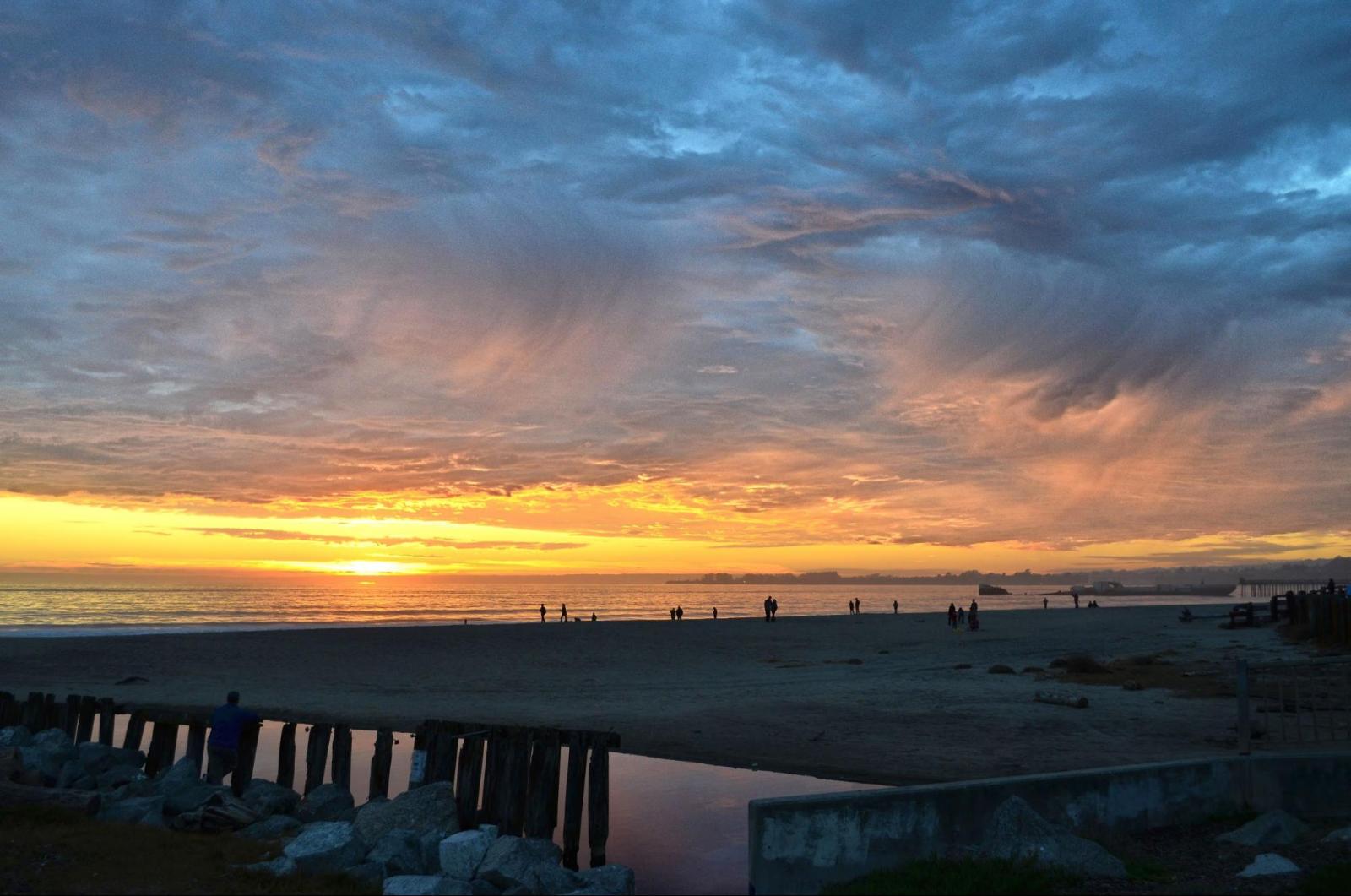
Virga is ghostly precipitation that never makes it to the ground. When the air beneath a cloud is very dry, precipitation falling through it evaporates before reaching Earth’s surface. What’s left are feathery streaks extending from the cloud’s base, capturing the path the rain or ice took before becoming water vapor. The evaporation process takes a lot of energy out of the surrounding air and causes it to cool. That cold air may then sink very quickly and dump a dangerously concentrated parcel of air and water/hail in a microburst.
But for the most part, virga is a visual effect. It shows up on radar as a typical rain or snow shower, but there’s no evidence of that at the surface. Great storms could be raging above your head, but the only trace you’ll see are the thin wisps of virga drifting through the sky.
https://www.flickr.com/photos/nws/21837318119/in/album-72157659594562055/
Photo courtesy of Valerie Lemke. A picture of virga taken at Rio Del Mar Beach in Aptos, CA. Virga is commonly seen in the Western U.S., desert climates, and other dry areas.
When two hurricanes spinning in the same direction pass close enough to each other, they begin an intense dance around their common center. If one hurricane is a lot stronger than the other, the smaller one will orbit it and eventually come crashing into its vortex to be absorbed. Two storms closer in strength can gravitate towards each other until they reach a common point and merge, or merely spin each other around for a while before shooting off on their own paths. But often, the effect is additive when hurricanes come together — we usually end up with one massive storm instead of two smaller ones.
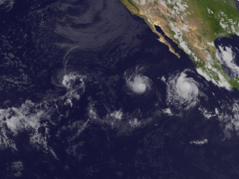
GOES-16 satellite imagery over the eastern Pacific Ocean from July 25 to August 1, 2017. Hurricane Irwin on the left collided with Hurricane Hilary on the right; the two merged before fading out over the ocean.
Heat bursts occur in the wake of dying thunderstorms, but other conditions have to be just right — the storm has to be high in the atmosphere and the air beneath must be hot and dry. When the storm rains into this arid environment, the water quickly evaporates. Evaporation takes heat energy out of the surrounding air and causes it to cool and contract, so we end up with a very dense parcel of air too heavy to stay up. It begins to fall through the atmosphere, and the quicker it’s losing heat, the quicker it falls.
Normally, moisture is still evaporating while it descends. This offsets the heating that happens as the falling air is squished by the layers of air above it. But in the case of a heat burst, all of the moisture evaporates and that dense air is only getting warmer as it approaches the ground at high speeds. When it hits, it suddenly delivers oppressively hot and dry air that can stay in place for hours.
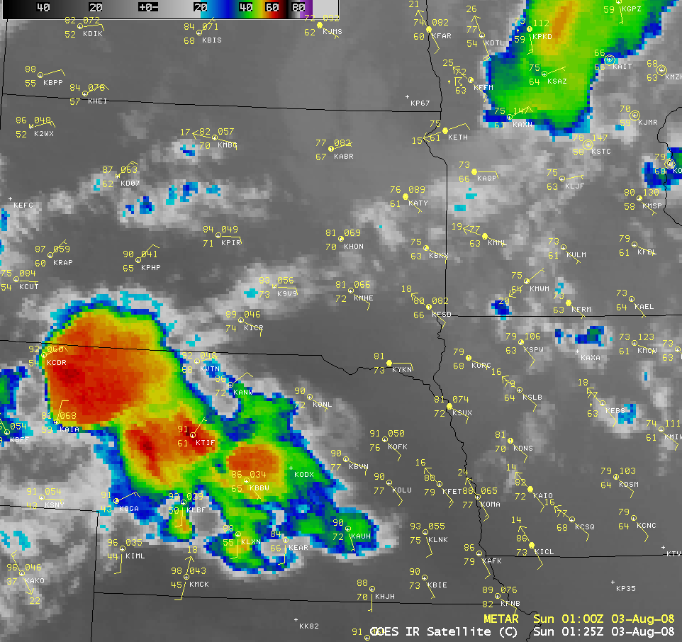
http://cimss.ssec.wisc.edu/goes/blog/wp-content/uploads/2008/08/080803_g12_ir_1_anim.gif
AWIPS images of GOES-12 10.7 µm IR channel. A group of thunderstorms moving across Nebraska and South Dakota, followed by a heat burst over Sioux Falls, SD. This phenomena is most common in late spring and summer at night, since most thunderstorms expend their energy during the daytime.
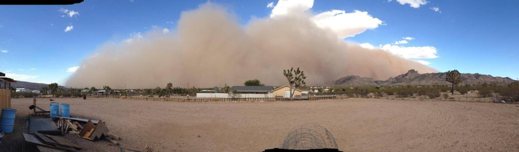
Haboobs are powerful dust storms that can happen anywhere but are most often seen around northern Africa and the southwestern US. What do those regions have in common? A lot of hot, dry air and loose particles.
Haboobs form when a thunderstorm collapses and either all the air it collected is blown out in powerful gusts, or the air within it cools and falls rapidly to the surface in a microburst. The strong winds it releases are pushed in front of the storm and pick up dust and debris to create a wall thousands of feet high and miles across. There’s no outrunning these massive storms, so make sure to be in a safe place indoors ahead of time!
 https://twitter.com/nwsvegas/status/484196533202472960
Photo courtesy of Joe DuArte NWS Las Vegas. A haboob advancing on Dolan Springs, AZ. Haboobs typically only last minutes, but they rapidly reduce visibility and air quality.
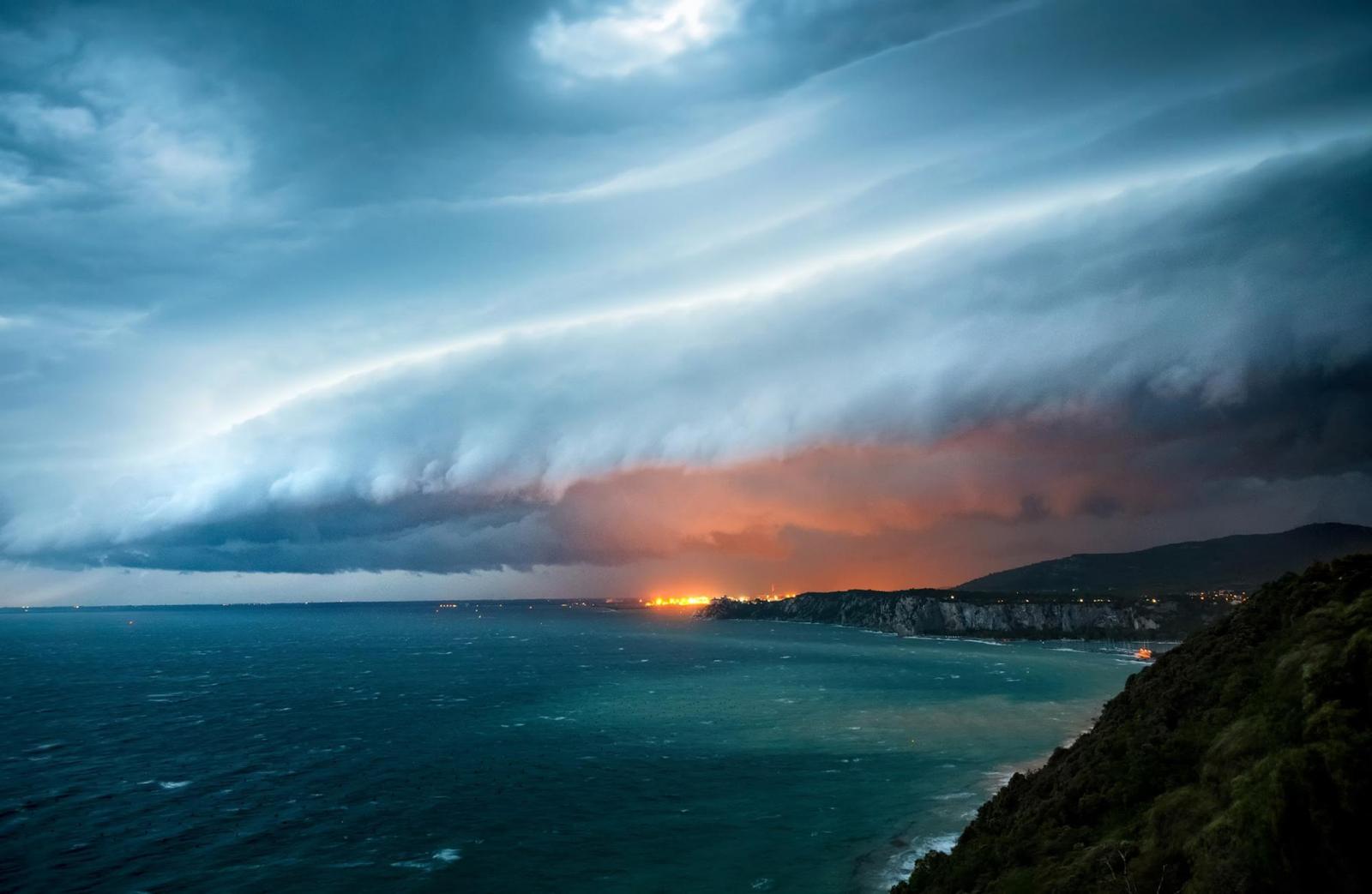
Thunderstorms can come in all sorts of forms. Sometimes they arrive in a line all pushed up by by the same thing, which is usually a cold front. The widespread lifting means that we end up with a lengthy area with the right conditions to make thunderstorms.
Squall lines form from this and keep themselves going; the air that rushes out of a thunderstorm when it collapses can become the fuel for a forming storm as long as the pressure and moisture conditions remain right. They bring strong, straight winds, rain, hail, and lightning in their wakes and less often can generate tornadoes.
A derecho is a type of severe storm squall line. Its high pressure system distorts the line’s shape and causes it to bow out. Derechos are defined by having at least 58 mph winds and damage over 250 miles; their devastation is akin to tornadoes, but only occurs in one straight direction.
https://www.flickr.com/photos/nws/21841882958/in/album-72157659594562055/
Photo courtesy of Marko Korosec. A massive cold front with squall line over northern Adriatic sea, Italy on May 12, 2014. Squall lines can be hundreds of miles long.
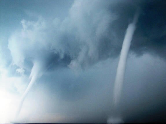
Appearing as tornadoes of water, waterspouts are an eye-catching small-scale phenomena. They can simply be tornadoes that moved from land to bodies of water, but oftentimes they form in fair weather and cause little harm.
Fair weather waterspouts form on the surface of open water. Warm temperatures and high humidity, especially in a localized area, can cause air to rise with enough strength that water is drawn up with it into a funnel. They usually don’t go beyond the lowest intensity for tornadoes, EF0, and last fewer than 20 minutes.
Unsuspecting marine life can also get sucked up with the water and then dumped over land — waterspouts are responsible for all those incidents of raining fish and frogs!
https://www.flickr.com/photos/nws/21415542284/in/album-72157659865470536/
Photo courtesy of Tim Osborn. A pair of waterspouts formed off the coast of Grand Isle, LA. Waterspouts are most common in tropical areas, but have also been seen over the Great Lakes, Antarctic waters, and the Saint Lawrence River.
The impressive spew that comes from an erupting volcano has all sorts of things mixed in it, including superheated chunks of rock and gases shooting into the sky. But, along with all that, it’s not rare to see lightning shooting from the ash cloud!
Usually, we see lightning [can we link to Owlie’s May 4 journal?] because small bits of ice form in thunderclouds. Thunderclouds always have winds blowing upward and downward, so those particles will crash together and become electrically charged. The same thing happens when you rub your hair on a balloon — both parts in contact get electrified, and that’s why your positively-charged hair sticks to the negatively-charged balloon. Opposite charges attract.
The same thing happens in a more chaotic environment inside a thunderstorm. Some of the ice formations are heavier than others, which means some lighter particles become positively charged and rise to the top of the storm, and denser, negatively charged one stay near the bottom. Lightning is a big spark of electricity connecting points with imbalanced charges, whether they’re between two regions of the cloud or the cloud and the ground, and makes them balance out until there’s another buildup.
But in a volcano, there’s no ice forming inside ash clouds. Instead, the bits of broken rock are the ones rubbing against each other and creating electricity; because lightning can be 5 times hotter than the Sun and volcanoes are so dangerous, it’s hard to study the details of this phenomena. However, the heat of the lightning often turns the ash it touches to liquid, which later solidifies into little spheres of glass that can tell us about how long and hot the strike was.
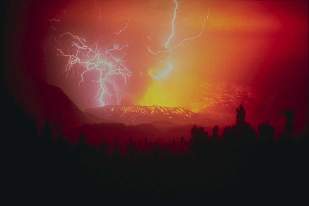
Image courtesy of R. Hadian, U.S. Geological Survey. The December 3, 1982 eruption of Galunggung in western Java, Indonesia. Volcanic lightning tends to occur in explosive eruptions.
Ring around the moon means rain soon — sometimes. It’s not uncommon to see circles of light around the sun or moon, and halos have fueled superstition for centuries. But there’s nothing unnatural about how these ghostly rings form.
Though you might see them in a clear sky, the culprit are wispy clouds tens of thousands of feet above the surface. They often form ahead of rain or snow, but they’re no guarantee it’ll land; likewise, halos don’t actually predict the weather. Halos form because of a special property of these types of clouds: Instead of being made of tiny water droplets, they’re composed of ice crystals. When we get that high up in the atmosphere, temperatures are too low for water to stay liquid.
The ice acts as a prism, so when light hits it, all the colors that make it up get separated out like in a rainbow. That’s why the halo has pale bands of different colors. The ice also reflects this separated light outwards so we can see it. You have to be positioned just right to catch a distinctive circle around the sun or moon, since how the light is reflected depends on how you look at it. It’s called a 22° halo because we split the sky up into 360°, and the radius of the halo usually spans about 22° of that — about as big as your handspan held an arm's length in front of your face.
https://www.flickr.com/photos/nws/22013573046/in/album-72157657596361014/
Photo courtesy of Kevin League. A lunar halo over Montana.
“I want to tell you that on the day after the departure of our brothers Kuntz and Michel, on a Friday, we saw three suns in the sky for a good long time, about an hour…Even though the other two suns were not as bright as the one, they were clearly visible. I feel this was no small miracle.” — Jakob Hutter, 1533.
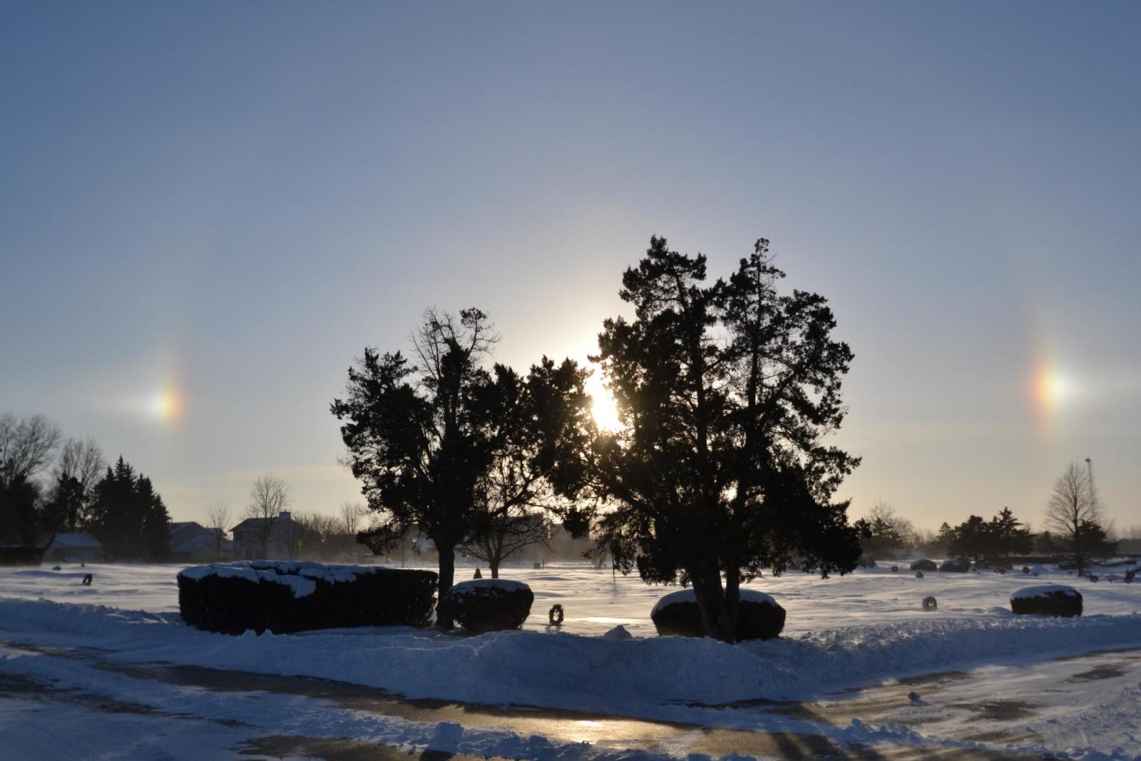
What Hutter saw nearly 500 years ago is one of the most common types of halos, a vision created by light reflecting just right to form mock suns. The effect goes by several names but officially called parhelion, and it can be spied from anywhere if the conditions are right.
The key to seeing parhelia is the presence of clouds made of tiny hexagon-shaped ice crystals instead of tiny drops of water. They tend to form high up in the atmosphere, where temperatures are too cold for water to stay liquid. When light hits the ice, it breaks up into all the different colors that make it up, which is the same way rainbows get their color.
The ice crystals need to be falling to the ground for the light to be reflected where we can see it. The ice is very small and gently drifts and floats on the wind with its hexagonal face nearly horizontal. Every crystal is breaking up the sun’s rays, but the ones we see forming parhelia are only those at the same level as our eyes, acting like mirrors reflecting light directly at us. The glimmer from individual bits of ice come together to form pale, false suns in line with the real one.
https://www.flickr.com/photos/nws/21417132954/in/album-72157657596361014/
Photo courtesy of Zack Riel. A photo of two parhelia taken in -14 degrees Fahrenheit weather.
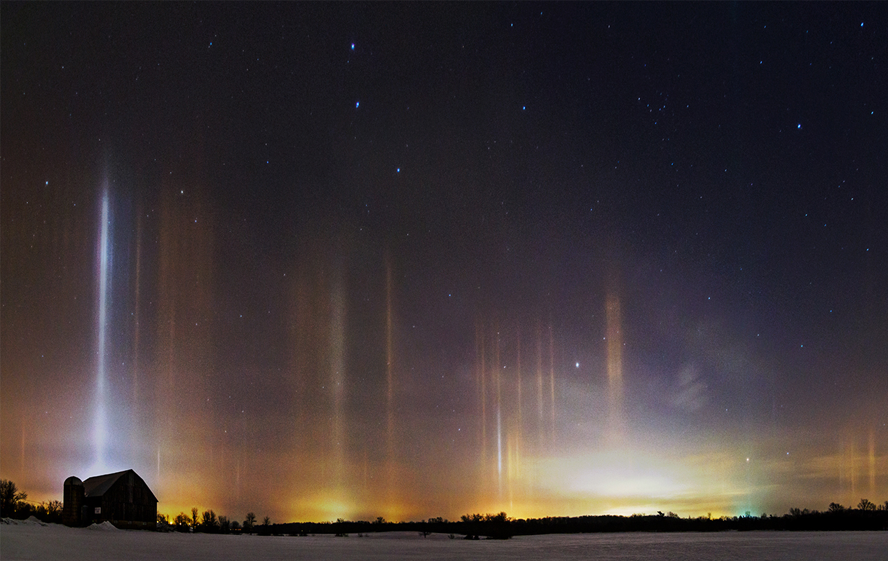
Long pillars of multicolored light streaking the sky seem like the perfect backdrop for impending alien invasion, but in reality, light pillars are a common effect that can be found all over the world.
They do come from above — not extraterrestrials, but tiny crystals of ice hanging in the atmosphere. Ice is very thin, shaped like plates with hexagonal faces. When ice drifts down through the air, it falls close to horizontally. At the top and bottom are the faces with more area. Ice is very reflective, so when light hits those wider faces, it bounces around and reflects off more ice crystals.
That means we get these vertically stacked mirrors floating in the atmosphere. The light hitting it gets reflected up and up (or down and down, depending on the source), and becomes a radiant column in the sky.
Light can come from the sun, moon, cities, street lights — any strong light source.
https://www.flickr.com/photos/nws/21417383923/in/album-72157659865441056/
Photo courtesy of Matt Molloy. The way a light pillar looks depends on how high up the ice crystals are, what shape they are, how they’re angled, and how far away the light source is.
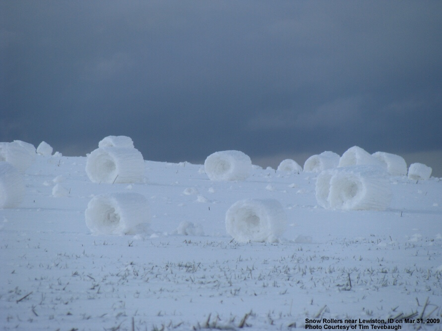
Sometimes, a combination of mundane ingredients can make something unexpected. Nature’s recipe for snow rollers, little doughnut-like formations of rolled snow, are no different.
These delicate formations need just the right mix of moisture, snow, wind, and temperature. The snow has to be a light dusting, sticky enough to adhere to itself but on a surface that it won’t cling to. The wind has to be strong enough to encourage these mounds of snow to curl up and form their signature loop, but not so strong that the whole thing gets blown apart. Alternatively, the snow could be on a hill and gently roll downslope to form the same shape.
Either way, snow rollers are rare, distinctive finds in nature that are impossible to replicate. If you see one, be sure to appreciate what perfect conditions came together to make it!
https://www.wrh.noaa.gov/otx/photo_gallery/snow_rollers.php
Photo courtesy of Tim Tevebaugh. A field of snow rollers in the southern Idaho Panhandle. The rollers here are about 18 inches tall or more.
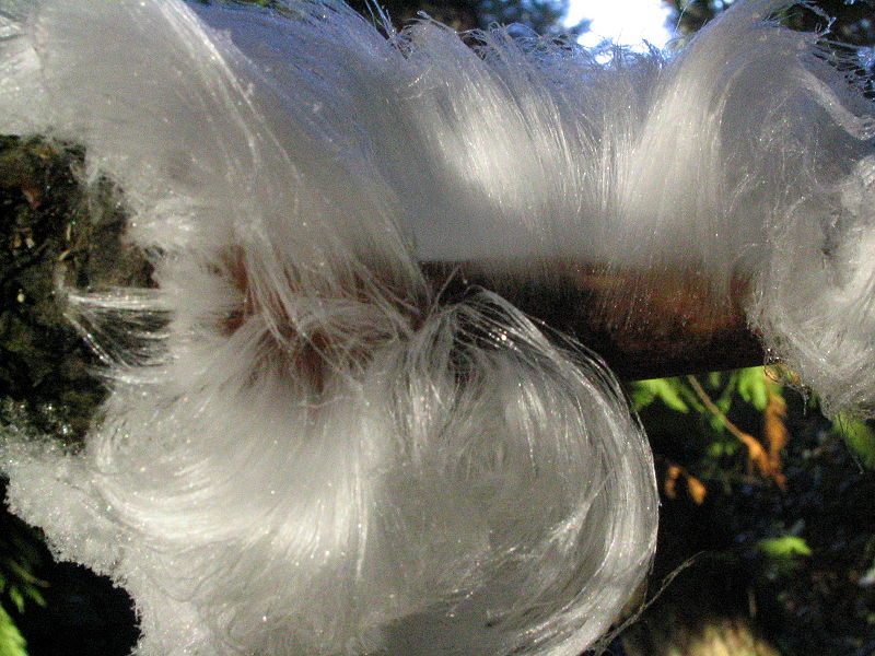
On cold and humid nights in some northern forests, you can find something strange growing on rotting branches. It’s ice, but nothing like you’ve seen before. There are thousands of long, thin strands of the stuff, as thick as human hair and all packed together in soft waves. What you’re looking at is, fittingly enough, called hair ice.
The way these woolly growths formed had puzzled scientists since 1918, but we know the culprit now — it’s a fungus!
The fungus grows on dead tree bark, and when ice starts to form along its surface, the fungus releases chemicals that shape it into the distinctive narrow strands. Those chemicals also prevent the small, thin ice crystals from growing into larger ones and keep the hairy texture structured. Hair ice can stay in place for days in the right conditions, but often it forms in the cooler temperatures of night and melts away in the morning.
https://en.wikipedia.org/wiki/File:FrostBeardDetail.jpg (public domain)
A growth of hair ice on a dead tree branch in British Columbia, Canada. Alfred Wegener, the father of continental drift, first saw hair ice in 1918 and correctly thought they could be the work of a fungus. It took almost 100 years to prove him right.
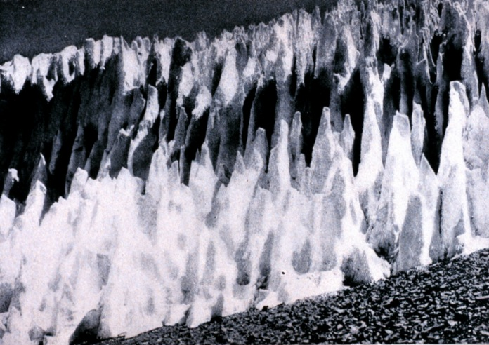
Nieves penitentes are tall, sharp juts of ice with wide bases and narrow tops. They can be just a few inches tall or tower over your head at 16 feet and are usually found in large groups pointing towards the sun. You can probably see similarities to all sorts of things in these striking figures, but officially they’re named after their resemblance to monks in robes — in Spanish, the penitentes.
They form in high, dry environments where the lack of humidity means ice doesn’t melt into water, but instead goes directly from a solid to gas in a process called sublimation. When the sun shines on the ice, it hits at a particular angle and only some parts get heated up. They sublimate away faster than the surrounding area, so we get a dimple in the ice. The curved surfaces in that dimple concentrate the sun’s rays, so that area sublimates even faster. We end up with these tall spikes of ice that have deep scoops in their surface.
Some scientists believe that impurities in the snow also contribute to making nieves penitentes. The impurities would make some parts of the snow darker than others, so they’d absorb more sunlight and cause the dimples to form.
Recently, we’ve been finding nieves penitentes in less local places. NASA found penitentes on Pluto rising hundreds of feet high.
http://www.photolib.noaa.gov/htmls/wea03001.htm
Nieves penitentes in the Argentine Andes. Charles Darwin was the first person to scientifically write about these structures in 1839.
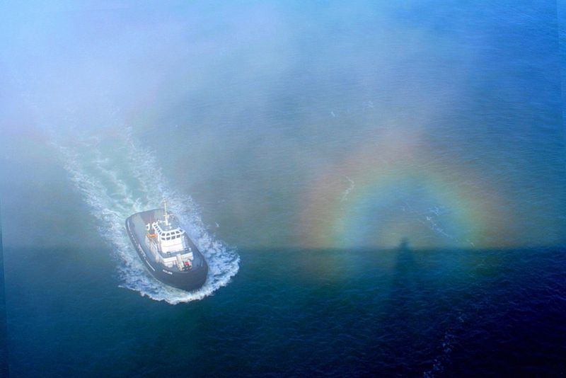
A glory is an optical effect that casts a rainbow halo around the head of an observer’s shadow. The conditions for it are usually best in high places, like mountains and tall buildings, which are also the right environments for elongated shadows called Brocken spectres to form. Together, they make quite a striking scene.
Glories appear when light hits the little water droplets making up clouds or fog. The light separates out into the different colors that make it up, the same way it does in a rainbow. Because of the way light bounces around in the droplets, we get a small series of circles instead of a big arcing bow.
Glories are often seen when you’re high above the ground because the water droplets in the clouds or fog have to be level with the light source, and that light source has to be below you. That way, the halo lands at the head of your shadow.
Brocken spectres have the same requirements. When you cast your shadow down into clouds or fog, the light exaggerates your figure. You seem much larger and longer-limbed, and you may appear to be moving because of movement in the water droplets. These unnerving shapes coupled with glories fueled superstitions for centuries.
https://en.wikipedia.org/wiki/File:Glory,_spectre.jpg (public domain)
A glory created by sun and fog surrounding a Brocken spectre. Taken from the Golden Gate Bridge, CA.
Thick, lens-shaped masses hovering through the sky. Bright, white, and ominous… Well, not quite. Though they have a history of being mistaken for flying saucers, lenticular clouds really are just clouds.
These clouds form when stable air is pushed up by some sort of barrier, whether that’s a mountain or a building or an art installation. The air might cool as it goes up and then begin to sink because colder air is heavier than warm, creating a wave. The moisture in the air packs together into the distinct vertical stack of lenticular clouds.
Unlike other clouds, lenticular clouds don’t drift much. They are fed by the air rising over the barrier, but when they sink and return to warmer parts of the atmosphere, the water in them evaporate
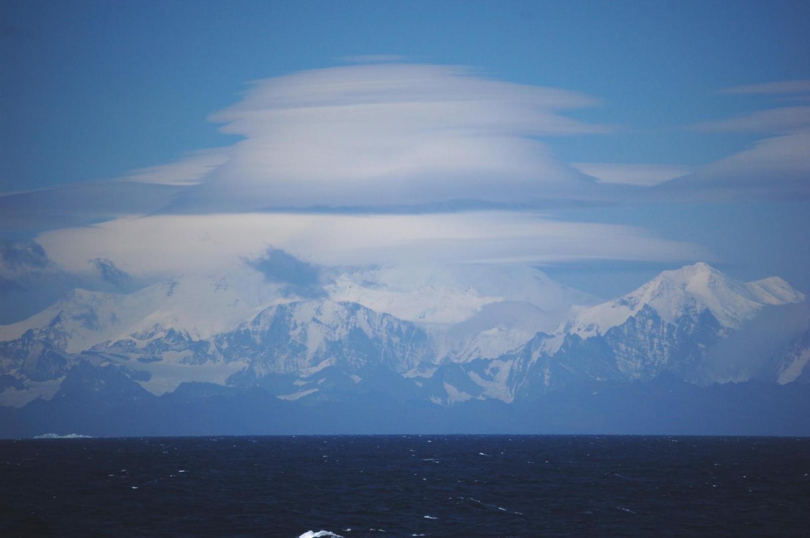 s.
s.
http://www.prh.noaa.gov/hnl/pages/events/lenticular/
Photo courtesy of Lieutenant Elizabeth Crapo. Lenticular clouds over South Georgia Island. They most commonly form in the Western U.S. because of the Rockies, but they can form anywhere with the right conditions.
It’s exactly what it sounds like. On a clear day, you can see the edges of Earth’s shadow at twilight creeping up or down the horizon. It’s a dark bluish band that appears opposite to the rising or setting sun.
The Earth is really big and curved, and its shadow is the same way. In fact, it’s over 800,000 miles long and projects far, far into space. That’s how we get lunar eclipses; the moon is only one-third that distance from us, so when the sun and Earth line up with it, it gets blocked out by the planet’s massive shadow.
Often, you can see the Belt of Venus on top of it as a strip of pink (though it has no actual relation to the planet Venus). It forms because it reflects light from the sun’s rays. The division between this light and the darkness of Earth’s shadow becomes less distinct as the sun sets until it’s entirely night.
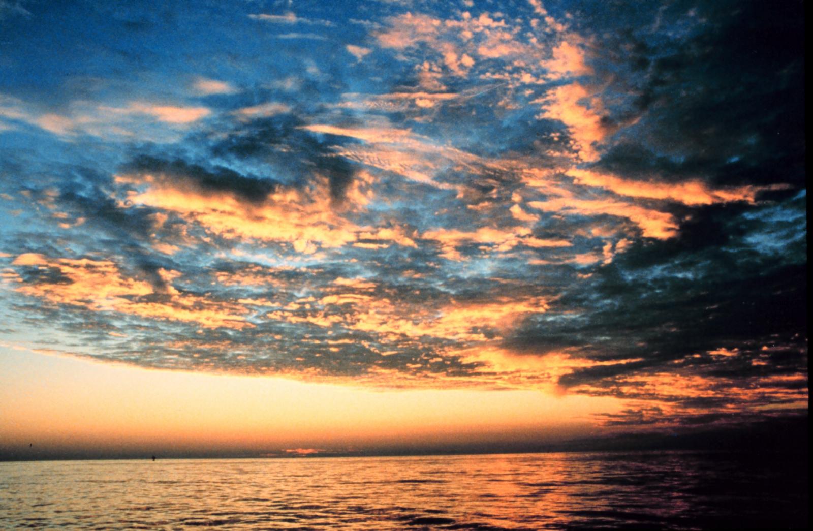
Photo courtesy of Commander Grady Tuell. Sunset over the Gulf of America. The Earth’s shadow looks almost black in this shot, with the peachier Belt of Venus on top of it.
Power flashes are easy to confuse with lightning, but they’re not the work of thunderclouds. Power flashes are what we get when when power lines get damaged and short out, often because of powerful storms and winds.
Naturally, this effect is most common at night, when it’s hard to distinguish what’s happening where. There are a couple things unique to power flashes, though:
Power flashes frequently happen because of tornadoes and hurricanes. Often, these types of severe storms bring a lot of debris and rain that can make them hard to see, especially at night. We can use power flashes to identify where exactly a storm is.
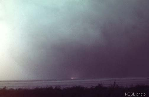
The pictured Tipton, OH tornado was a massive vortex hidden in veils of rain. A power flash cut through all the murkiness to reveal where the tornado actually was.
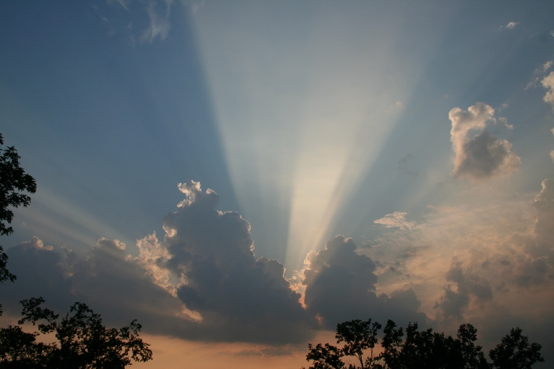
Sometimes you’ll find yourself bathed in a spotlight of sunlight, streaming out of the clouds at slanted angles. Those alternating bands of light and shadow are crepuscular rays; their name comes from the Latin word for twilight, when they are most easy to see.
The effect comes depends on having a lot of particles in the atmosphere, such as dust, moisture, and pollutants. When the sun’s rays hit those things, their light scatters into a beam that we can see. The clouds encasing the light need to be darker and shadowy to give that strip of light edges. All together, this makes for a concentrated band of light. Depending on where the sun is in the sky, they can have tinges of colors different from their typical yellow.
And in reality, those rays aren’t actually going off in crooked directions. They’re shining in straight lines, but because we are so far away from the sun, our perspective makes it look like all the rays are getting narrower towards it.
https://www.weather.gov/lmk/photoalbum_sunsets_2010
Photo courtesy of David Pence. Crepuscular rays over Richmond, Kentucky.

