National Weather Service United States Department of Commerce
 
Map of US

On this page you learn what types of flooding are typical in Alaska and how to you protect yourself, your family and your home. You will also find out more about significant Alaska floods. Finally, you'll find links to NWS offices that provide forecast and safety information for Alaska, as well as links to our partners who play a significant role in keeping you safe.

Significant Alaska Floods

+1967 Tanana Valley Flood

+Yukon River Ice Jam Flood, May 2013

April and early May 2013 were the coldest in decades in Interior Alaska. As a result, the winter snowpack in the Yukon River basin, which was generally near normal at the start of spring, remained in place weeks later than normal, and river ice remained solid. Flooding on the Yukon River in Alaska occurred at Eagle on May 17, when a short-lived ice jam backed up water into several homes. The community of Circle City flooded on the morning of May 19, when an ice jam developed just below town. Almost every building in town had some water damage. Fortunately, the jam broken quickly and the water receded. A major ice jam formed above Fort Yukon, but rather than releasing all at once, the jam was gradually eroded and as a result there was only minor flooding. 

By far the worst flooding occurred at the middle Yukon community of Galena. An ice jam formed May 26 at Bishop Rock, 18 miles downriver from Galena. Ice backed up more than 40 miles behind the jam before the jam released on May 29. As the water rose at Galena on the 26th, evacuations began, and by the 28th most residents were evacuated by air. Those remaining were forced to camp at the levee-protected airport without electricity or waste water sanitation. Some buildings in the old section of town were lifted off their foundations and floated away. The vast majority of buildings sustained flood damage and many were uninhabitable, and most of the old town section will not be rebuilt. A federal disaster declaration was issued in late June. 

Recovery was slowed by the extent of infrastructure damage: even the road to the dump washed out and had to be rerouted. Because the Galena school was housing some residents as well as recovery personal who were working over the summer, school was 3 weeks late in resuming in the autumn. The combined costs to the state and federal governments for relief and recovery efforts, as of early October 2013 were estimated to exceed $80 million. Fortunately, there were no deaths or serious injuries.
May 28, 2003 looking north, showing the ice-clogged Yukon River. The dike-protected airport is clearly visible

+1994 Koyukuk River Flood

Two separate periods of prolonged heavy rain during mid and late August 1994 in the Koyukuk River Basin produced severe flooding in middle sections of the river. Rainfall amounts during the second half of August in the region were generally 50-75% of the normal annual total. All 200+ residents evacuated from the neighboring communities of Allakaket and Alatna, where almost every building was damaged or destroyed by water that in some places was 10 feet deep. Farther downriver at Hughes, damage was less complete but still substantial. The area was declared a national disaster in September 1994. Because the flooding occurred so late in the summer, many residents were forced to spend the winter in other communities. Rebuilding took place primarily in the summer of 1995. Total damage exceeded of $15 million. Total cost including repair, relocation, evacuation and mitigation exceeded $70 million (1995 dollars). Ther were no deaths or serious injuries.
 
Snoqualmie River November 6, 2006. Photo courtesy of King County
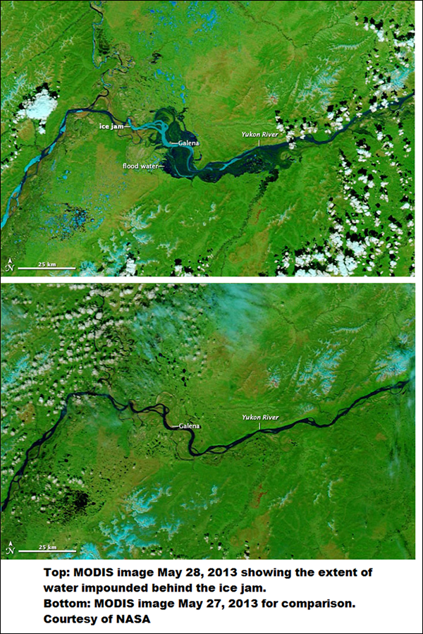
Photo courtesy of Alaska Division of Community & Regional Affairs


+Autumn 1995 South-Central Alaska Flooding

Persistent warm, moist southerly flow during mid and late September 1995 and the resulting orographically focused rains produced severe flooding across parts of south central Alaska. Some low elevation locations received in excess of 20 inches of rain in a week and twice that amount likely fell at some higher elevations. Unusually high freezing levels for so late in the season allowed for significant high elevation glacier and snowmelt which contributed to the very high water levels. Peak water volumes on the Eagle and Knik Rivers north of Anchorage were estimated to have reached a once in 500 years level. Damage was especially severe along the Kenai River and in Seward and Girdwood. The lower Kenai River on the Kenai Peninsula crested September 24 and remained above flood stage for moer than 10 days. Impacts of the flooding includes damage to cabins, permanent homes, sewage treatment facilities, roads, trails, bridges, power transmission lines, airports and railroad facilities. Fast currents caused significant bank erosion, channel shifting, and damage to dikes and levees. Total damage was estimated at over $10 million and the President declared it a Federal Disaster Area area October 1995. There were no deaths or serious injuries.

The impacts of this flood are still felt today, with bankside restoration undertaken to mitigate future flooding. A much improved network of river and rain gauges, including some at higher elevations, was installed in the aftermath of this flood to provide better monitoring and improved forecasts.
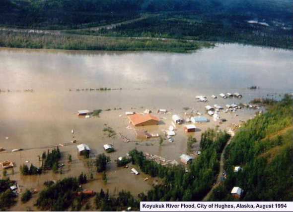
National Weather Service Flood Report: South Central Alaska Floods Sep 19- October 2, 1995

+Glacier Dammed Lake Outburst Flooding

A unique flooding issue in Alaska involves lakes that form behind glaciers. Many of Alaska’s glaciers flow across the mouths of adjoining valleys and cause lakes to form behind the ice. These ice dams are subject to repeated failure and as the volume of the lake enters into the downstream rivers, it can cause extreme and sudden rises in water level and may result in minor to major flooding.

One location famous for destructive flood events is on the Knik River near Palmer. From 1918-1963, Lake George formed behind the Knik glacier and annually emptied in July or August and then refilled. At the time, Lake George was the largest glacier dammed lake in Alaska and the regular release turned into such a spectacle that the area was designated as a Natural Landmark by the National Park Service. Something changed in the mid 1960s and after 1966, the lake stopped forming (Post and Mayo, 1971).

Another dramatic glacier dam release occurred from a lake on the Skilak Glacier above Skilak Lake on the Kenai River in 1969. The volume of the release was relatively small, causing less than a foot rise on Skilak Lake, but the timing of the release, in January, caused a breakup of the river ice which moved downstream and jammed the river causing flooded roads, homes and businesses in the middle of the winter and then freezing in place. Glacier dammed lakes on the Snow and Skilak glaciers release regularly on the Kenai River, typically every 2 years and cause a 2-4 foot rise on the river, which can result in flooding depending on the river level at the time of the release.

 A final example of glacier dammed lakes is the one formed by the Hubbard Glacier in Russell Fiord. Hubbard glacier (upper left of the map) has threatened to close the gap entirely, preventing Russell Fiord from flowing into the Gulf of Alaska through Disenchantment Bay. In 2002, the glacier actually closed the gap sufficiently that the inflows to Russell Fiord exceeded the outflows through the restricted space by a considerable margin, raising the level of Russell Lake by 61 feet above sea level over a 2½ month period. When the lake started to erode through the glacial blockage, the outflow increased significantly, eventually releasing about 0.9 cubic miles of water. The peak outflow exceeded the peak historic flow of the Mississippi River at Baton Rouge by about 30%. The Hubbard Glacier continues to surge and eventually is likely to close off the gap entirely. Several federal agencies continue to monitor Hubbard Glacier because if the gap does close, the resulting lake could rise to 130 ft above sea level at which point it would spill into the Situk River near Yakutat which is a prized salmon and steelhead stream.

Snoqualmie River November 6, 2006. Photo courtesy of King County

Learn More:

Flood Hazard Information

+Flash Flooding

Flash flooding is a rapid and extreme flow of high water into a normally dry area, or a rapid water level rise in a stream or creek above a predetermined flood level, beginning within six hours of the causative event (i.e., intense rainfall, dam failure, ice jam). More information...

+River Flooding

River flooding occurs when river levels rise and overflow their banks or the edges of their main channel and inundate areas that are normally dry. More information...

+Tropical Systems and Coastal Flooding

At any time of year, a storm from over the ocean can bring heavy precipitation to the U.S. coasts. Whether such a storm is tropical or not, prolonged periods of heavy precipitation can cause flooding in coastal areas, as well as further inland as the storm moves on shore. More information...

+Burn Scars/Debris Flows

Wildfires burn away the vegetation of an area, leaving behind bare ground that tends to repel water. When rain falls, it runs off a burn scar towards a low lying area, sometimes carrying branches, soil and other debris along with it. Without vegetation to hold the soil in place, flooding can produce mud and debris flows. More information...

+Ice/Debris Jams

A back-up of water into surrounding areas can occur when a river or stream is blocked by a build-up of ice or other debris. Debris Jam: A back-up of water into surrounding areas can occur when a river or stream is blocked by a build-up of debris. More information...

+Snowmelt

Flooding due to snowmelt most often occurs in the spring when rapidly warming temperatures quickly melt the snow. The water runs off the already saturated ground into nearby streams and rivers, causing them to rapidly rise and, in some cases, overflow their banks. More information...

+Dam Breaks/Levee Failure

A break or failure can occur with little to no warning. Most often they are caused by water overtopping the structure, excessive seepage through the surrounding ground, or a structural failure. More information...
 
Flood Hazard Information                        NWS Forecast Offices and River Forecast Centers (RFC) Covering Alaska