National Weather Service United States Department of Commerce
 
Map of US, click for text equivalent

On this page you learn what types of flooding are typical in Arizona and how do you protect yourself, your family and your home. You will also find out more about the signficant Arizona floods. Finally, you'll find links to NWS offices that provide forecast and safety information for Arizona, as well as links to our partners who play a significant role in keeping you safe.

Significant Arizona Floods

+Record Floods of February 18-26, 1891

+Spring Flood of 1978 (February 23-March 3)

The historic flood of 1903 affected the Missouri, Arizona, and lower Republican River Basins. The flooding along the Arizona River during May 1903 was the greatest since 1844. A total of 57 people died, 38 of those were in Topeka. The Topeka Daily Capital also reported that 4,000 people were driven from their homes. The Lawrence Daily Journal reported "Desolation everywhere, north side a complete wilderness, country for miles around one vast sheet of water and homes and property have been swept away to destruction."

Learn More: A prolonged moist southwest upper air flow produced significant rainfall on the steep slopes of the Mogollon Rim. Flooding occurred over much of the state as a result of the rainfall. Amounts ranged from 1-4 inches in the south-central part of the state, 3-6 inches in the central basins, and five to eleven inches over and just below the Rim and White Mountains. These rains were just the latest in a long series of significant rains that began in late December 1977. The previous rains saturated watersheds, raised stream levels, and nearly filled most reservoirs. The most extensive flooding occurred in the Salt and Verde Basins. Although there was some snow melt above 6,500 feet, most of the runoff resulted from the rain. Runoff into the Salt River above Roosevelt Dam was contained by Roosevelt Lake but the smaller dams could not contain runoff that came down the Verde River and the Salt River below Roosevelt Dam. As a result, a huge volume of water rushed down the normally dry Salt River bed and became a raging torrent through the Phoenix area and western Maricopa County. Volume at the peak was 138,000 cfs on March 2.

In the Phoenix area, approaches to eight street bridges were washed away, leaving only three intact to handle the daily movement of tens of thousands of vehicles. Traffic was backed up for miles during the rush hours for about a week until the flow of water was contained in the reservoirs and approaches were filled back in on some of the crossings. The water broke about 2,000 feet of the east end of the main runway at Phoenix Sky Harbor Airport into large chunks and damaged airport radio and radar facilities. Thousands of homes were damaged and more than 100 homes were destroyed. Flooding also occurred along the Little Colorado River, with considerable damage occurring in the Winslow area. Most of the runoff came from tributaries with headwaters on the Mogollon Rim. There were minor overflows of the Gila River with some damage in the Safford Valley and at Duncan. On the Hopi and Navajo Indian Reservations, most of the roads were made impassable, stranding about 10,000 individuals. Food had to be air lifted in, as well as fodder for livestock. This event resulted in four fatalities and damages estimated at $65.9 million.

Vanport levee failure, May 30, 1948 (USACE)
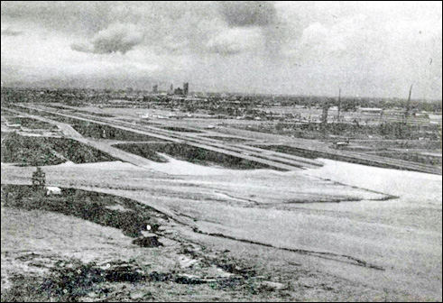
Approximately 2,500 feet of runway at Sky Harbor International Airport is washed away as the flow in the Salt River approaches 122,000 cubic feet per second. From U.S. Army Corps of Engineers Los Angeles District February 1979 Flood Damage Report.

Learn More:

+1970 Labor Day Floods

The 1970 Labor Day floods still remain Arizona’s deadliest storm, with a total of 23 deaths. The heavy precipitation that developed surged north into the state ahead of Tropical Storm Norma, which had moved just off the tip of Baja, CA. Strong southerly winds developed over the state ahead of an approaching cold front, providing lift for the moisture over the higher terrain in the state and producing heavy rainfall. The heaviest rainfall occurred in the mountainous areas of central Arizona, with numerous precipitation stations recorded 5-8 inches of rainfall in 24 hours. One station recorded 11.40”, establishing a new all-time record for 24-hour precipitation in Arizona. Especially large flows occurred on the Tonto, Sycamore, Oak and Beaver Creeks, and the East Verde and Hassayampa Rivers. In the Tonto Creek Basin, 15 people who were spending the Labor Day weekend at cabins or camping along Tonto Creek died as flood waters surged along Tonto and Christopher Creeks sweeping house trailers, campers and automobiles away and destroying cabins. Many dwellings, roads, bridges, and other structures were also damaged or destroyed by the record flooding. Damage was estimated at $5.8 million.


Morrison Bridge and Willamette River in Portland (Ellis Lucia)
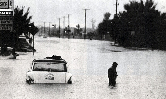
Flooding at Van Buren and 48th Street, Phoenix. (Courtesy:Â The Arizona Republic, Phoenix, AZ)
Morrison Bridge and Willamette River in Portland (Ellis Lucia)
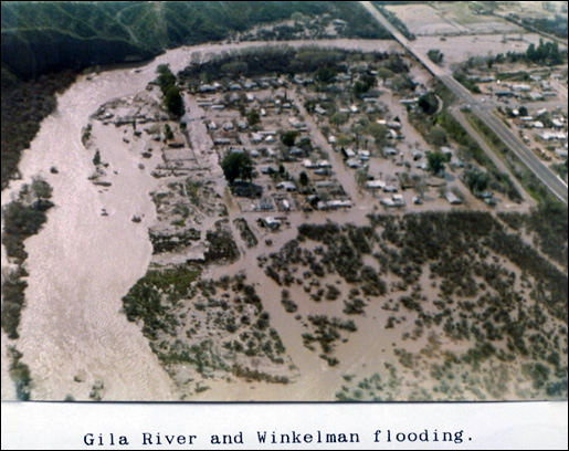
Kohl’s Ranch Area; upper Tonto Creek near junction of Horton Creek. (From:Â Department of Commerce, Natural Disaster Survey Report 70-2)

Learn More:

+Tropical Storm Octave, October 1-3, 1983

Moisture from Tropical Storm Octave moved northeastward across Arizona for several days in October 1983 resulting in $370 million in flood damage in southeastern Arizona. Rainfall was most intense in a narrow band from south of Tucson to Clifton. Peak discharges on the Santa Cruz River at Tucson and on Aravaipa Creek were more than twice those observed in the previous 65 years. Recently installed soil-cement stream bank reinforcement helped to limit damage in Tucson, however, the city lost several buildings to erosion. Large areas northwest of Tucson were inundated as floodwaters from the Santa Cruz and Gila Rivers spread across flat fields. The flood was the largest on record on the San Francisco River at Clifton. There were 14 fatalities and 975 injuries attributed to the flooding and at least 10,000 people were left temporarily homeless. This massive storm also brought floodwaters north along the Santa Cruz and Gila rivers to Maricopa County, causing extensive flooding of streets and highways and the flooding of homes and businesses. One freeway underpass was filled with 9 feet of water.


Willamette River flooding Oregon City, Oregon, photos courtesy Lew Scholl

Photos:

Learn More:

+Winter Floods of January 6-19 1993

In January 1993, an unusual series of Pacific storm systems tracked across Arizona, producing heavy and prolonged precipitation across the state. Rainfall amounts during the event averaged in excess of 3 inches over a large portion of the state. Some heavier amounts exceeded 7 inches. This heavy rain, coupled with melting snow, produced intense runoff, necessitating high releases from virtually all reservoirs in the Salt, Verde, and Gila river basins. Flooding was the most widespread and severe it had been in Arizona since the turn of the century.


The highest flows of record were observed at some stream flow gaging stations in every major river basin in the state. The protracted rainfall over the 2-week period caused multiple flood peaks on most streams and rivers and resulted in the inundation of a large number of communities throughout the state. A large garbage landfill and portions of the new Mill Avenue bridge, under construction in Tempe, were washed away by the raging Salt River. The Gillespie Dam west of Phoenix was damaged, as high water spread throughout low-lying areas. Roads, bridges, homes and businesses suffered considerable damage in Pima County. Several thousand people were isolated in their homes, as flood waters from the Rillito River cut off all roads. Two major bridges over the Santa Cruz River were closed as well as many roads in Greenlee and Graham Counties due to flooding. Duncan was one of the hardest hit, with half of the town flooded when a dike broke, leaving at least 150 people homeless. Uncontrolled flow passed over the Coolidge Dam spillways for the first time since it was built: 8 deaths and 112 injuries were attributed to the floods. Estimated damages to public and private property exceeded $400 million (U.S. Army Corps of Engineers, 1994). This flood event resulted in Arizona creating a Flood Warning Multi-Agency Task Force to improve interagency coordination and for the establishment of a flood warning system for the state.

Photos:

Learn More:

Flood Hazard Information

+Flash Flooding

Flash flooding is a rapid and extreme flow of high water into a normally dry area, or a rapid water level rise in a stream or creek above a predetermined flood level, beginning within six hours of the causative event (i.e., intense rainfall, dam failure, ice jam). More information...

+River Flooding

River flooding occurs when river levels rise and overflow their banks or the edges of their main channel and inundate areas that are normally dry. More information...

+Tropical Systems and Coastal Flooding

At any time of year, a storm from over the ocean can bring heavy precipitation to the U.S. coasts. Whether such a storm is tropical or not, prolonged periods of heavy precipitation can cause flooding in coastal areas, as well as further inland as the storm moves on shore. More information...

+Burn Scars/Debris Flows

Wildfires burn away the vegetation of an area, leaving behind bare ground that tends to repel water. When rain falls, it runs off a burn scar towards a low lying area, sometimes carrying branches, soil and other debris along with it. Without vegetation to hold the soil in place, flooding can produce mud and debris flows. More information...

+Ice/Debris Jams

A back-up of water into surrounding areas can occur when a river or stream is blocked by a build-up of ice or other debris. Debris Jam: A back-up of water into surrounding areas can occur when a river or stream is blocked by a build-up of debris. More information...

+Snowmelt

Flooding due to snowmelt most often occurs in the spring when rapidly warming temperatures quickly melt the snow. The water runs off the already saturated ground into nearby streams and rivers, causing them to rapidly rise and, in some cases, overflow their banks.More ainformation...

+Dry Wash

When heavy rain falls over extremely dry land, the water rushes towards low-lying areas, which may include dried up canyon or river beds. This can quickly turn a dry channel into a raging river. More information...

+Dam Breaks/Levee Failure

A break or failure can occur with little to no warning. Most often they are caused by water overtopping the structure, excessive seepage through the surrounding ground, or a structural failure. More information...
 
Protect Life and Property           NWS Forecast Offices and River Forecast Centers (RFC) Covering Arizona