On this page you learn what types of flooding are typical in Illinois and how do you protect yourself, your family and your home. You will also find out more about significant Illinois floods. Finally, you'll find links to NWS offices that provide forecast and safety information for Illinois, as well as links to our partners who play a significant role in keeping you safe.
Rainfall totals of 8 to 15 inches occurred with the storm, in addition to the massive storm surge produced by the hurricane. Storm surge flooding damaged the entire Mississippi Gulf Coast, pushing debris as far north as Interstate 10. Homes, buildings, and businesses that survived Hurricane Camille were lost in Hurricane Katrina, with damages extending from Mobile, AL, westward. As Hurricane Katrina moved inland, a swath of 5 to 8 inches of rain fell along its path. This heavy rain mainly fell across southeast, central and northeast Mississippi over a 6 to 10 hour period. This rainfall caused many county roads to flood for a period of time with many having to be closed. Additionally, several roads had a small section washed out or nearly washed out. These sections of road were located in low lying areas near creeks and bottoms.
Learn MoreMississippi Storm Surge Records from Weather Underground
Bay St. Louis:
25.0 ft., Hurricane Katrina, 2005
21.7 ft., Hurricane Camille, 1969
15.2 ft., September 1947 Hurricane
Pass Christian:
27.8 ft., Hurricane Katrina, 2005
22.6 ft., Hurricane Camille, 1969
13.4 ft., September 1947 Hurricane
Long Beach:
25.7 ft., Hurricane Katrina, 2005
21.6 ft., Hurricane Camille, 1969
14.0 ft., September 1947 Hurricane
Gulfport:
24.5 ft., Hurricane Katrina, 2005
21.0 ft., Hurricane Camille, 1969
14.0 ft., September 1947 Hurricane
Biloxi:
22.0 ft., Hurricane Katrina, 2005
19.5 ft., Hurricane Camille, 1969
11.1 ft., September 1947 Hurricane
Pascagoula:
18.0 ft., Hurricane Katrina, 2005
11.8 ft., Hurricane Camille, 1969
9.0 ft., September 1947 Hurricane
A wet winter and early spring season set the stage for major flooding in April of 1979. Heavy rains brought flash flooding to portions of northeast and much of central Mississippi from the 11th to the 13th of April, but this was only a prelude to the widespread and record or near record flooding for the remainder of the month.
The large tornado-breeding storm system that severely damaged Wichita Falls, TX, and spread into Oklahoma on the 10th set off heavy rainfall across Mississippi from the 11th to 13th. From 10 to 20 inches of rainfall fell across portions of the Upper Pearl, Tombigbee, Big Black, and Upper Chickasawhay River Basins.
Moderate to major flooding occurred along the Tombigbee River and tributaries above Columbus, MS. Record flooding occurred along the Tombigbee tributaries of the Luxapallila Creek and Noxubee River. The record to near record flooding continued on the Tombigbee into Alabama. Eastern Columbus and Macon were totally inundated by flood waters. Record to near record flooding occurred along the Big Black River and portions of the Upper Chickasawhay.
The most significant damage occurred along the Pearl River System where near record to record flooding occurred all the way to the mouth of the river in Louisiana. Peak discharges approached or exceeded those of the Great Flood of 1874. Flood waters covered residences in northeast Jackson and overtopped a levee near downtown Jackson area allowing water to flood low lying areas in the Central Business District. As the water proceeded to the mouth, evacuations were issued along the river including eastern portions of Slidell, LA.
Learn More:
Magee, near the headwaters of the Leaf River, received just over 20 inches of rainfall in a 36-hour period, while sites at the mouth of the river received over 6 inches. The Leaf River at Hattiesburg broke its all-time record stage height with 34.03 feet. This record still stands as of January 2014. Tallahala Creek at Laurel had its highest crest since 1919.
Over 6,000 people were evacuated from their homes in Hattiesburg and Forrest County. More than six square miles of Hattiesburg were inundated with flooding, with water 15 feet deep in places.
Learn More:
A series of three storm systems tracked through the South from February 16-25, dumping extreme amounts of rainfall. Accumulated rainfall totals of up to 18 inches occurred in southeast Louisiana and Mississippi and in central and south Alabama. As a result, extensive flooding occurred throughout central and southeast Mississippi.
Many locations in the Pearl and Pascagoula River Basins approached and broke their all-time record crests. The Leaf River at Hattiesburg crested at 31.53 feet breaking the record at the time. This record was broken in 1974 at 34.03 feet. Hattiesburg received the most flood damage, in part due to its size. Nearly 5,000 people were evacuated from their homes in the city. Black Creek at Brooklyn and the Chickasawhay River at Enterprise both set their highest crests up to that time as well.
Many locations in the Pascagoula Basin reached or exceeded their 50-year floods. In the upper and middle Pearl River Basin, flooding was not as extreme. The Pearl River at Edinburg reached a peak discharge, which qualified for a 14-year flood. Even the Sunflower River at Sunflower in the Delta had a recurrence interval of about 10 years.
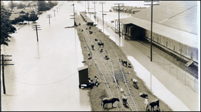
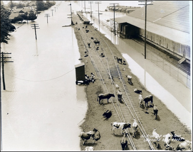
Damage was extensive throughout the state. Jackson, Hattiesburg and Petal received the greatest damage. Roadways and railways, residential and commercial property, as well as agricultural lands and livestock, were all destroyed. County roads had more damage than State Highways. Numerous winter crops were destroyed. Livestock drowned. Houses, buildings, fences, and other farm property were damaged as well. Other losses included the scouring of the land and leaching of fertilizer from the soil.
|
||||||

