On this page you learn what types of flooding are typical in Nevada and how do you protect yourself, your family and your home. You will also find out more about significant Nevada floods. Finally, you'll find links to NWS offices that provide forecast and safety information for Nevada, as well as links to our partners who play a significant role in keeping you safe.
Flooding was caused by warm, heavy rain on heavy snow and frozen ground. Most bridges in the region were destroyed, as were many roads and many miles of railroad. Most tributaries to the Humboldt were inundated from the headwaters near Deeth to its terminus at the Humboldt Sink near Lovelock. The Humboldt River at Carlin was over a mile wide, and Western Pacific dynamited ice to save the Carlin bridge. Five railroad bridges at Beowawe and Battle Mountain were condemned, and the steel railroad bridge at Palisade nearly failed. Reservoirs north of Elko failed and 10 feet of water ran into town. Most ranches on the Humboldt River were flooded and the cattle were driven to the high ground, with considerable loss of livestock region-wide.
On the Mary’s River, the Western and Southern Pacific Railroad bridges near Deeth were covered with 3 feet of water. The Bullion Bridge on the South Fork Humboldt was washed out, isolating the mining camp of Bullion for almost 2 weeks; the road to Bullion had to be rebuilt. Many bridges on the South Fork Humboldt and Tenmile, Huntington and Lamoille Creeks were destroyed or severely weakened with considerable road damage.
The North Fork Humboldt joined with the Mary’s River and inflicted damage to the railroads in the Elko area. Both Maggie and Susie Creeks flooded, adding to the inundation of Carlin. In Pine Valley, nearly 30 miles of the Eureka and Palisade Railway line in lower Pine Valley were completely destroyed, causing it to be closed until May 1912. The town of Palisade south of the Southern Pacific Railroad was washed away in this flood. The remainder of the town was destroyed by a fire in July 1910 and it was never rebuilt.
The area between Beowawe and Battle Mountain became an extensive lake and in March the Humboldt River was 4 to 5 miles wide near Dunphy and Boulder Flat, and further downstream, Kelly Creek was 1.5 miles wide at its junction with the Humboldt River. The railroad between Battle Mountain and Carlin was severely disrupted from February 28 to March 9 due to washouts, and several westbound passenger trains were stalled in Palisade while eastbound trains were held up at Winnemucca and Battle Mountain. At least 12 Western Pacific bridges between Carlin and Winnemucca over the Humboldt were destroyed or greatly weakened.
The Reese River flooded along its entire length, one of the few times in recorded history that this has happened, washing out over 5 miles of Nevada Central Railroad track through Reese River Canyon, as well as 12 railroad bridges over the Reese. At Battle Mountain, the Reese formed a large lake behind the Southern Pacific Railroad Grade, flooding large portions of the town. High water from Trout and Mill Creeks in the lower Shoshone Range washed out several sections of the railroad near Battle Mountain, causing additional flooding.
On the Little Humboldt River northeast of Winnemucca, there was considerable damage with bridges and ranches washed out and freight and supply routes closed. Paradise Valley was flooded with a sheet of water at least 2 miles wide. Below Paradise Valley, Gumboot Lake formed above the Sand Dunes, which eventually broke through, sending a flood through Winnemucca to the Humboldt River, one of the few times this has happened in recorded history.
In Winnemucca, the river reached the doors of the Winnemucca Hotel on Bridge Street, and on March 1, the Bridge Street iron bridge was severely damaged. Riverside homes and businesses were flooded. On March 15, a Western Pacific train was derailed into the river east of town, and the bridge was heavily damaged.
Flooding along the Humboldt River also caused extensive damage in the Lovelock Valley in Pershing County. Nearly all of the valley’s diversion and canal systems were destroyed, including the Big Five diversion dam and reservoir, at that time the largest such structure in Nevada. All the lands downstream of these structures were inundated with flood waters.
|
|
Learn More:
Severe and widespread damages in the upper portion of the Humboldt Basin, especially on the Mary’s River, North Fork Humboldt, Maggie Creek, Susie Creek, Rock Creek and Reese River were comparable to the 1910 flood event. The 1962 flood was the worst flood of record on those basins. Damage or destruction of highway, railway, structural and other infrastructure in the region was severe. Elko received little damage due to its levee system.
Flood records from the 1962 which still stand in 2013 include: Mary’s River nr Deeth, 4,210 cfs; North Fork Humboldt near Halleck, 10,400 cfs; Maggie Creek near Carlin, 2,440 cfs; Rock Creek near Battle Mountain, 4,800 cfs.
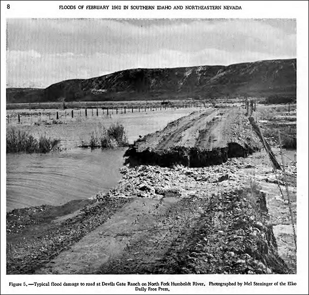
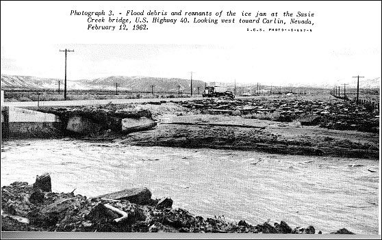
Storms in January 1962 dumped heavy snow on northeastern Nevada. As temperatures fell, the ground froze to an unusual depth. Rains came in February, quickly running off the frozen soil, generating serious flooding on the Humboldt River and tributaries, especially in Deeth, Carlin and Battle Mountain.
Nevada Highway Department shops and many residences were flooded in Deeth. There was widespread damage to irrigation ditches, headgates, and cultivated fields on the North Fork Humboldt Basin. Many cattle drowned and the U.S. Highway 40 Bridge over the North Fork Humboldt was severely damaged. The Western Pacific Railroad Bridge at Ryndon failed due to the flood.
Portions of railyards and the lower residential areas in Carlin flooded. Both the Southern Pacific and Western Pacific railroad grades were weakened, hampering rail traffic. The Southern Pacific railway yard at Carlin was flooded by ice jams and high water on Maggie and Susie creeks.
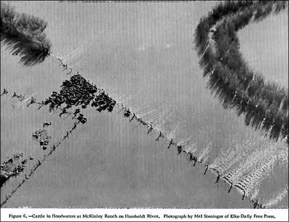
Between Beowawe and Battle Mountain, some 1,500 head of cattle died from malnutrition and disease. Many diversion and irrigation structures throughout this area were damaged or destroyed.
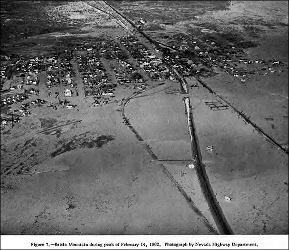
Battle Mountain suffered most, mostly due to severe flooding on the Reese River backing up at the Southern Pacific Railroad bed and U.S. Highway 40. Heavy rain on snow and frozen ground on the Reese caused major flooding from the Antelope Valley in mid-basin north to the Humboldt. The lower Reese River formed a lake 3 miles long behind U.S. 40 southeast of Battle Mountain. Floodwaters in Battle Mountain were from 2 to 5 feet deep over 95 percent of the town by February 12. More than 200 of the town’s 700 residents had to be evacuated from their homes, causing over $1 million in damages to residences, businesses, streets and public buildings. There was one death.
The flooding in Battle Mountain was severe because the Southern Pacific’s raised track bed kept floodwaters from draining. Some Battle Mountain residents took matters into their own hands and dynamited the tracks. Railroad crews tried to seal one of the breaches with sandbags, but angry citizens blasted it open again. To avoid violence, a Reno District Court judge issued a restraining order against the railroad, preventing it from interfering with flood mitigation efforts for 15 days. The State Highway Department cut a gap in U.S. 40 to allow Reese River backwater to drain into the Humboldt, and the flooding ended in Battle Mountain after the 13th.
As a result of the flood, the U.S. Army Corps of Engineers constructed a 7,200-foot long, 5-foot high levee along the eastern portion of the town from U.S. 40 (now Interstate 80) to North Battle Mountain Road to better channel the flood flows of the Reese River.
“Floods of February 1962 in Southern Idaho and Northeastern Nevada”; 1962: http://pubs.usgs.gov/circ/1962/0467/report.pdf
“Floods of February 1962 in Southern Idaho and Northeastern Nevada”; 1962: http://pubs.usgs.gov/circ/1962/0467/report.pdf
“Floods of February 1962 in Southern Idaho and Northeastern Nevada”; 1962: http://pubs.usgs.gov/circ/1962/0467/report.pdf
“Water and Related Land Resources, Humboldt River Basin Nevada, Report Number 9, Battle Mountain Sub-Basin”, October 1964, Nevada Department of Conservation and Natural Resources and U.S. Dept. of Agriculture.
Learn More:
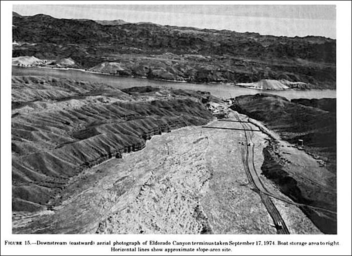
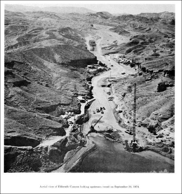
A devastating flash flood struck the canyon at about 2:30 pm on September 14, 1974. In addition to killing at least 9 people, it destroyed 5 trailer homes and damaged many others, obliterated a restaurant, destroyed 9 cabins, 38 vehicles, 23 boats, 19 boat trailers, half of the boat docking facilities and the gas dock. For safety reasons, the resort has never been rebuilt.
The flood resulted from intense basin-wide rain and hail at rain rates up to 3 inches per half hour. The peak flow was estimated at 76,000 cubic feet per second by USGS just upstream of the developed area near the mouth of the canyon. The runoff dumped about 70 thousand cubic yards (about 100,000 tons) of sediment into Lake Mojave and throughout the lower part of the canyon, and caused a rise of about 0.45 foot on the Lake.
The flood was called a “catastrophe” by Clark County Coroner Dick Mayne and other members of the search and rescue team. Known dead included four men, three women and two children. Four storm characteristics were critical to flooding and damage:
The rainfall began about 1 pm and ended about 2:30 at Nelson, NV, about 6 miles upstream from El Dorado Canyon Resort on Lake Mojave. Rainfall was heaviest from about 1:45 to 2 pm, and total amounts in Nelson were about 2 inches. Heaviest amounts were in the middle and lower parts of the basin.
“A Hydrologic Assessment of the September 14, 1974 Flood in Eldorado Canyon, Nevada”; U.S. Geological Survey Professional Paper 930, 1975, Glancy and Harmsen
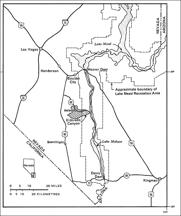
Location of Eldorado Canyon, Nevada.
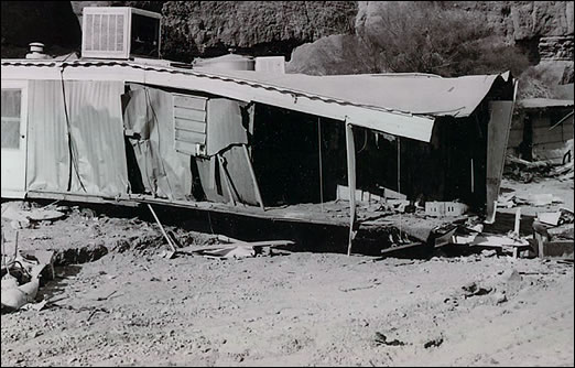
Damage to mobile home in Nelson’s Landing, University of Nevada Las Vegas Special Collections
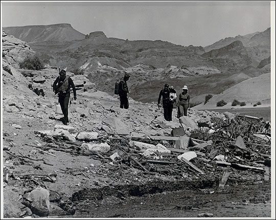
Scuba divers searching for those lost in flood in Lake Mojave after Eldorado Canyon flash flood, University of Nevada Las Vegas Special Collections
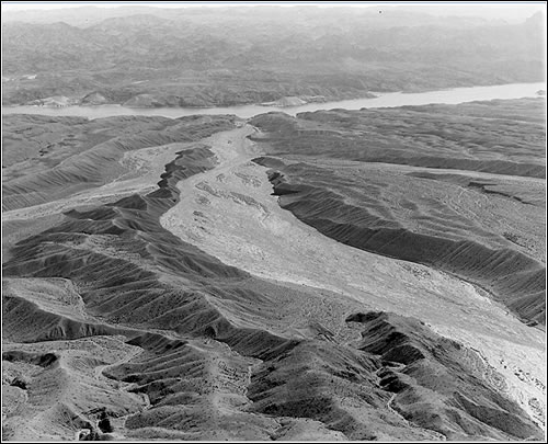
Flood path, El Dorado Canyon, looking downstream. Lake Mojave is in background, University of Nevada Las Vegas Special Collections
Learn More:
Flash floods are not unusual in the Las Vegas area. The alluvial fans around the valley contain large amounts of calcium carbonate, and when it is wet and then dries, caliche is formed. Caliche is almost impervious, so when there is rainfall in the valley, almost all of it runs off into the natural waterways which drain right into the city. The combination of widespread caliche and soil moisture can result in flash flooding from relatively moderate precipitation amounts.
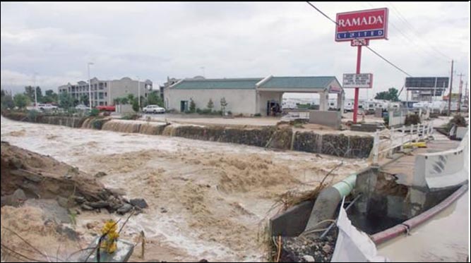
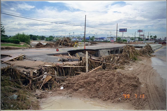
The resulting runoff from the torrential rain on July 8, 1999, caused widespread street flooding and record flows in normally dry washes and flood control detention basins, as well as two deaths and $25 million in damage (1999 dollars). Some 369 homes were damaged or destroyed. Sections of busy Interstates 15 and 95 resembled a lake, bringing traffic to a standstill. Most major intersections were under water.
Streets and washes quickly were overwhelmed by the tremendous runoff. Motorists and pedestrians were unprepared for the magnitude of these floods resulting in more than 200 swift-water rescues were performed by the Las Vegas and Clark County Fire Departments. In all, 275 storm-related emergency phone calls were logged by rescue officials in just 6 hours, with calls to 149 locations in a 15 minute period before noon. The floods caused severe erosion of unlined sections of some washes and damaged numerous roadways.
The Governor issued a Declaration of Emergency for the area and requested assistance from the Federal Emergency Management Agency on July 15. President Clinton declared the city a disaster area on July 19.
Extensive work by Clark County Regional Flood Control District to improve the wash system and drainage basins across the valley was just in the beginning phases in 1999, and much of the rainfall this day occurred downstream of existing detention basins.
This event fell between the 50 and 100-year flood criteria along parts of the Las Vegas Wash, according to the U.S. Geological Survey. Record flows occurred at several stations on Duck Creek, Flamingo Wash and the Las Vegas Wash.
Although the flood of September 11, 2012 was nearly as disastrous in the Las Vegas area, the flood of July 8, 1999, is still the record as of November 2013 at the following locations:
|
Flamingo Wash At Nellis Blvd Nr Las Vegas, NV |
5,600 cfs |
|
Las Vegas Wash Below Flamingo Wash Confluence Nr Las Vegas |
11,000 cfs* |
|
Las Vegas Wash Above Three Kids Wash Below Henderson, NV |
18,000 cfs |
|
Las Vegas Wash Overflow At Lake Las Vegas Inlet |
17,000 cfs |
|
Las Vegas Wash Below Lake Las Vegas Nr Boulder City, NV |
10,800 cfs |
*Only slightly exceeded by 9/11/2012 flood, 11,300 cfs
There were two deaths resulting from the flood: a motorist and a transient caught in Flamingo Wash. Road flooding included parts of Las Vegas Boulevard (“The Strip”). Floodwaters inundated a number of buildings including the Forum Shops at Caesars Palace, which had up to 2 feet of water inside. City Hall and the Mayor’s office suffered water damage. On the east side of the valley, a mobile home park near the Flamingo Wash suffered erosion resulting in one home falling into the wash and four others destroyed. The weight of water on roofs also resulted in two roof collapses; the roof on a grocery store and the other a motorcycle dealership.
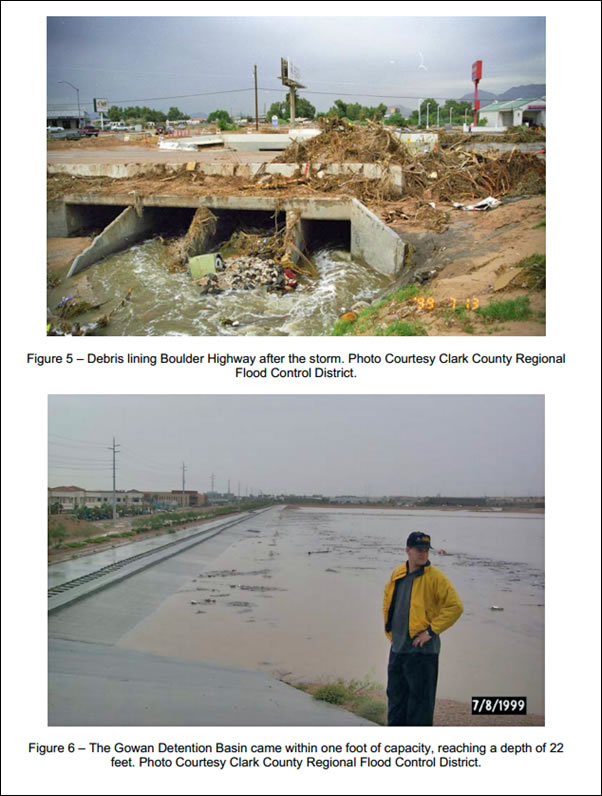
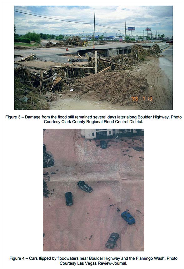
Boulder Highway destruction and debris, Photos from Clark County Regional Flood Control District.
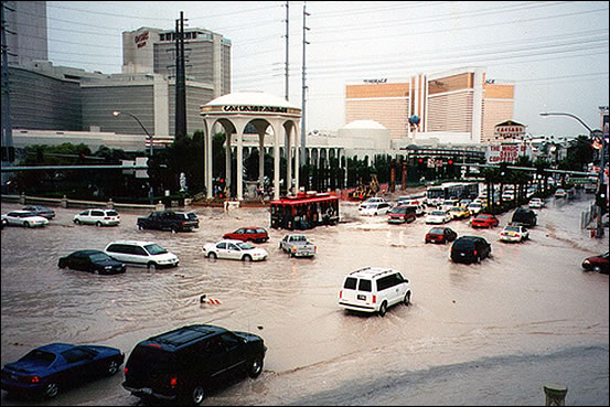
Flooding on the Las Vegas Strip near Caesar’s Palace, 7/8/1999; photographer unknown.
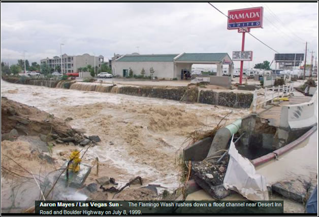
Photo of Las Vegas Flood, July 8, 1999, from Las Vegas Sun website
Learn More:
The January 1997 flood was result of near-record precipitation amounts and melting snow. Many locations in the region received 3–5 times their normal precipitation for December 1996 and January 1997.
Snowstorms in December dropped from 4–10 feet of snow above 6000 feet in the Sierra, with 2–3 feet in western Nevada valleys. The snow was followed by heavy rain from December 26–January 2, which also melted much of the snowpack. Precipitation amounts from December 30 to January 2, ranged from 1–3 inches in western Nevada valleys to over 22 inches in the high elevation Sierra stations.
The flooding claimed two lives: in Douglas County, a man was swept into the East Fork Carson River while operating a loader near its banks in Gardnerville on the evening of the Jan 2. In Washoe County, a man was swept into the Truckee River while retrieving personal belongings from his place of business in Sparks on January 3.
Flooding on the Truckee River destroyed or severely damaged many homes, businesses, warehouses, and roads in Placer and Nevada counties, CA, particularly in the towns of Tahoe City and Truckee. In Nevada, Washoe Clunty, Reno, Sparks, Lockwood, Wadsworth and Nixon were heavily hit and in Storey County, Lockwood was flooded. The Reno-Tahoe Airport, I-80 , and U.S. Highway 395 were closed for 2 days.
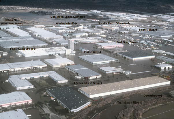
View of Sparks industrial area upstream of Vista gage looking just east of north on 1/3/1997 after flood crest on 1/2/1997. Truckee River is in bottom right, spprox. flow, 15,4000 cfs approx. stage, 21.5 feet (USGS Rating 35). Photo courtesy of Pat Glancy, USGS Carson City, NV
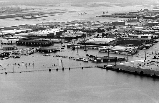
January 1997 floods. Reno-Tahoe International Airport flooded. Photo by Marilyn newton, Photo courtesy Reno Gazette-Journal
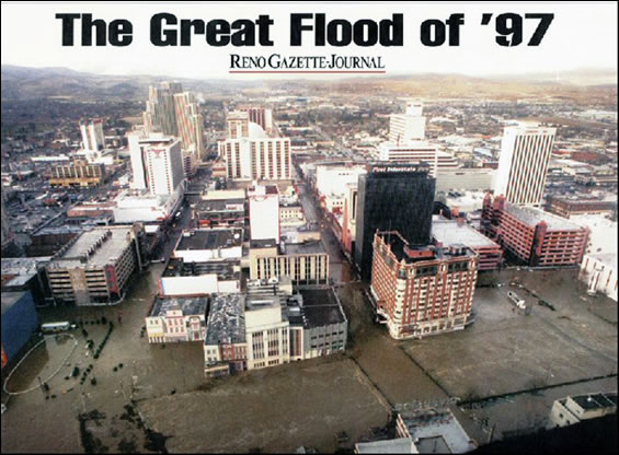
Downtown Reno, January 1, 1997 Photo Courtesy of Reno Gazette-Journal
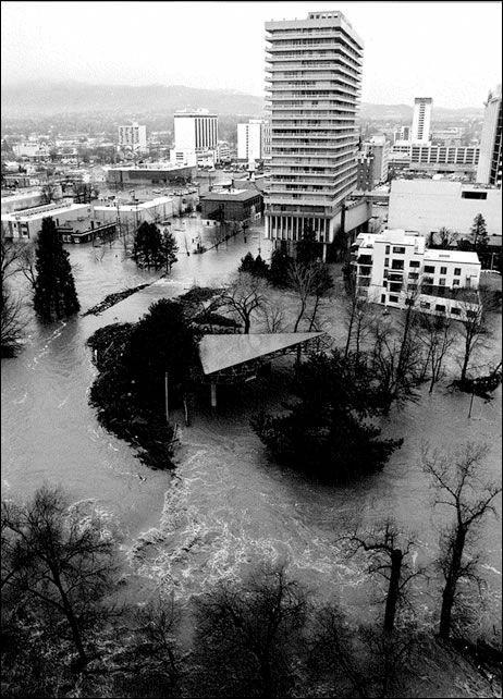
Wingfield Park, Arlington & 1st Streets, Downtown Reno, 1/2/1997. Photo Courtesy Reno Gazette Journal
Some 3,830 acres of the Truckee Meadows turned into a lake. Much of downtown Reno was flooded with several feet of water from West Second Street north of the river to Mill Street south of the river. All bridges crossing the river in downtown Reno were closed. The industrial area of Sparks was flooded with up to 6 feet of water causing extensive damage to structures and contents of warehouses.
The Federal Water Master prevented catastrophic flows on the lower Truckee River using flood control reservoirs at Stampede and Boca Dams on the Little Truckee River, and Prosser Dam on Prosser Creek. If these dams had not had storage space, the 1997 flood event would have been far worse, with peak flows 2–3 times greater than what occurred, as estimated by USGS.
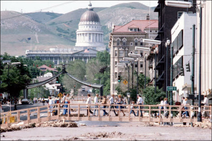
On the Carson River Basin, the January 1997 floods were the worst of record with the highest stages, flows and damages. The flooding destroyed or severely damaged homes and businesses in Alpine County, CA, towns of Woodfords and Markleeville; in the Douglas County, NV, towns of Minden, Gardnerville and Genoa; in Carson City, NV; and in the Lyon County, NV town of Dayton. About 34,000 acres of the Carson River drainage was flooded. The Carson Valley in the Minden-Gardnerville-Genoa area became a lake about 15 miles long and up to 5 miles wide.
The January 1997 flooding was the worst of record on the Walker River Basin. Extensive flooding caused massive destruction in Mono County, CA, especially in Walker, Coleville, Topaz, and Bridgeport, where 111 homes and 4 businesses were destroyed; and in Lyon County, NV, including Smith, Wellington, Mason, and Yerington where nearly 300 homes received extensive damage. A 12 mile stretch of U.S. Highway 395, between Topaz and Sonora Junction CA, was washed out by the West Walker River. The highway was closed until mid-summer 1997. Also, parts of Nevada Highways 208 and 339 in Wilson Canyon were completely destroyed. Mountain areas experienced extensive mud slides and debris flows, which closed major highways into the Lake Tahoe region.
Learn More:
|
||||||

