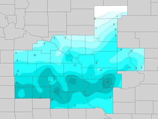
January 21, 2007 Snow Totals
Table listing of totals below the map.
PUBLIC INFORMATION STATEMENT
NATIONAL WEATHER SERVICE LA CROSSE WI
1125 AM CST MON JAN 22 2007
...STORM TOTAL SNOWFALL REPORTS...
LOCATION SNOWFALL
IOWA
...ALLAMAKEE COUNTY...
WAUKON 8NW 7.0
DORCHESTER 7.0
LANSING 4SE 6.5
...CHICKASAW COUNTY...
NEW HAMPTON 6.0
...CLAYTON COUNTY...
ELKADER 6.5
MCGREGOR 4W 6.0
MONONA 6E 5.9
ELKADER 6SSW 5.5
EDGEWOOD 4.5
...FAYETTE COUNTY...
FAYETTE 6.9
WESTGATE 3N 5.5
VOLGA 5.0
OELWEIN 1E 3.7
...FLOYD COUNTY...
NORA SPRINGS 6.3
CHARLES CITY COOP 6.5
CHARLES CITY 6.0
ROCKFORD 5.6
...HOWARD COUNTY...
ELMA 6.0
CRESCO 5.8
...MITCHELL COUNTY...
OSAGE 6.0
ST ANSGAR 5.8
TOETERVILLE 5.5
ST ANSGAR 7NW 5.5
...WINNESHIEK COUNTY...
CALMAR 7.2
DECORAH 10NE 6.5
WAUCOMA 3N 6.3
OSSIAN 6.0
KENDALLVILLE 4N 6.0
DECORAH WATER PLANT 5.5
DECORAH 5E 5.5
MINNESOTA
...DODGE COUNTY...
DODGE CENTER 3.5
MANTORVILLE 3E 3.3
MANTORVILLE 1E 3.0
...FILLMORE COUNTY...
PRESTON 8.0
FOUNTAIN 6.0
HIGHLAND 4.5
WYKOFF 3N 4.3
LANESBORO 4.1
...HOUSTON COUNTY...
RENO 3SW 5.5
CALEDONIA 1W 5.0
CALEDONIA 4.7
LA CRESCENT 1N 4.0
LA CRESCENT 9W 4.0
...MOWER COUNTY...
LE ROY 5.5
AUSTIN 5.0
LYLE 2NE 5.0
AUSTIN 5.0
GRAND MEADOW 4.5
...OLMSTED COUNTY...
CHATFIELD 4W 4.0
ROCHESTER 4.0
ROCHESTER AP 3.9
ROCHESTER 2NE AIRPORT 3.9
BYRON 3N 3.6
ORONOCO 3.6
DOVER 3S 3.5
BYRON 3.2
ELGIN 2SSW 2.7
...WABASHA COUNTY...
WABASHA 5S 3.8
THEILMAN 1SSW 3.6
OAK CENTER 2.5
READS LANDING 1W 2.3
ZUMBRO FALLS 2.3
WABASHA 1.8
...WINONA COUNTY...
ALTURA 5W 4.1
WINONA 3SSE 4.0
WINONA DAM 5A 4.0
WINONA (DAILY NEWS) 3.6
3S WINONA 3.5
GOODVIEW 3.5
WISCONSIN
...ADAMS COUNTY...
FRIENDSHIP 10NE 5.5
ARKDALE 4.0
MONROE CENTER 3.9
FRIENDSHIP 3.1
...BUFFALO COUNTY...
GILMANTON 8SE 2.5
MONDOVI 2.0
MONDOVI 6S 2.0
...CLARK COUNTY...
NEILLSVILLE 4NNE 3.0
NEILLSVILLE 3SW 2.0
OWEN 3N 0.9
...CRAWFORD COUNTY...
STEUBEN 6.2
GAYSMILLS 6.2
STEUBEN 4SE 4.8
...GRANT COUNTY...
MUSCODA 6S 5.8
KIELER 4.5
CASSVILLE 8 NE 4.3
CUBA CITY 2NW 4.1
SINSINAWA 3.8
PLATTEVILLE 3.7
...JACKSON COUNTY...
BLACK RIVER FALLS 2E 2.5
HIXTON 5W 2.0
...JUNEAU COUNTY...
MAUSTON 5.0
NEW LISBON 2N 4.0
NECEDAH 3SE 3.7
...LA CROSSE COUNTY...
LA CROSSE 5SE 4.9
LA CROSSE 4NNW 4.9
SHELBY 4.5
LA CROSSE AP 4.4
LA CROSSE WEATHER OFFICE 4.3
HOLMEN 2S 4.2
ONALASKA 3.8
...MONROE COUNTY...
SPARTA 2S 5.0
WARRENS 5WSW 4.8
TOMAH 4.0
...RICHLAND COUNTY...
BOAZ 6NNW 8.0
RICHLAND CENTER 6.0
...TAYLOR COUNTY...
GOODRICH 1E 1.0
MEDFORD 1S 0.8
PERKINSTOWN 5E 0.7
...TREMPEALEAU COUNTY...
ETTRICK 5SE 5.0
ETTRICK 2W 4.0
ARCADIA 3.0
GALESVILLE 1S 2.6
BLAIR 2.0
OSSEO 1.5
...VERNON COUNTY...
VICTORY 6.0
CHASEBURG 2S 5.5
COON VALLEY 5.5
VIROQUA 5.0
STODDARD 3NE 4.5
WESTBY 3.9
LA FARGE 3.3
WESTBY 3ENE 2.2
OBSERVATIONS ARE COLLECTED FROM A VARIETY OF SOURCES WITH VARYING
EQUIPMENT AND EXPOSURE. NOT ALL DATA LISTED IS CONSIDERED OFFICIAL.
$$


 Follow us on YouTube