|
In Brief
The 2011 water year (defined as October 1st to September 30th; listed year is the ending year) set new records for dryness at nearly every observing location in the Rio Grande Valley. The water year, believed to best describe agricultural land use by starting at the end of the growing season and middle of the crop harvest (October) and includes the spring and summer growing seasons that follow, began ominously with a three month driest ever period to end 2010, which was followed by a February Freeze and Ice Storm and a second shot of cold air before the 15th of the month.
Winter’s cold left as quickly as it arrived, with warm to hot, windy, and largely rain free weather dominating from mid February to mid June. For some, the period of March to May was both the warmest and driest on record. Much of June was sweltering, and drought intensified to exceptional for the entire Rio Grande Valley. The drought was epitomized by the a massive wildfire which burned more than 30,000 acres of Brooks County ranchland. Rains finally arrived on June 22nd and 23rd, and more would coat the Lower Valley on June 30th, putting a temporary dent into the water year drought, at least for the Lower Rio Grande Valley. Communities farther west and north would not fare as well, as water year rainfall remained at or below 5 inches with Extreme Drought continuing in Starr County and across the northern sections of Kenedy to Zapata County. Tropical Storm Don fizzled on July 29th, and August set all time heat records, pushing the meteorological summer (June to August) into the top ten for most locations.
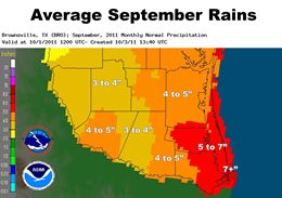
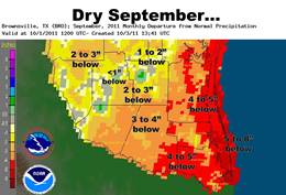
September
Normally the wettest month of the year in the Rio Grande Valley, 2011 continued the trend of August, which featured a predominant "La Canícula", or "dog days of summer" ridge of high pressure stretching from Texas through the southwest United States and northern Mexico. The ridge not only held firm, but temporarily strengthened during Labor Day Weekend (Dry air behind Tropical Storm Lee) and the following weekend to the north of Tropical Storm Nate.
|
September, Continued
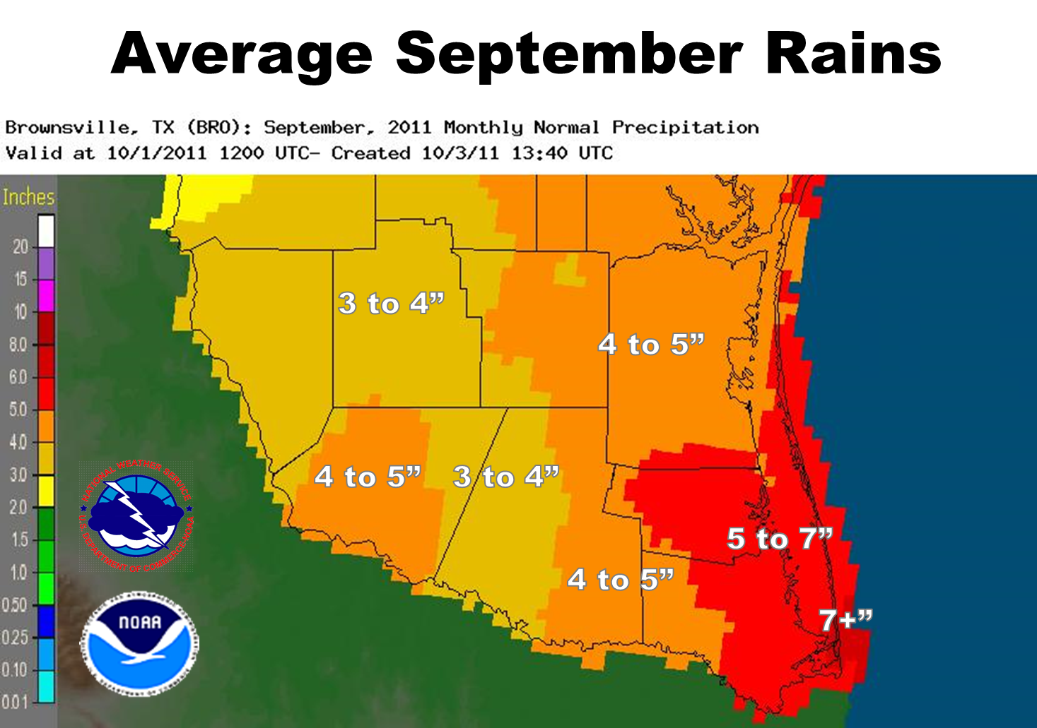
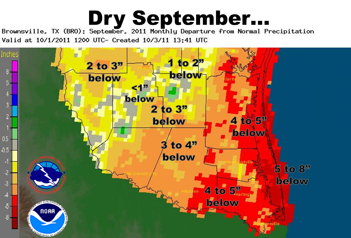
The persistent ridge, combined with rapidly drying soils, maintained temperatures hotter than July through virtually the entire month of September, particularly inland. McAllen/Miller airport shattered an all time monthly heat record and averaged 100°F for the monthly maximum temperature! Rainfall was virtually non existent for many locations; pockets of sea breeze storms brought a few inches to east central Cameron and Willacy County late in the month, and weak upper level energy combined with boundaries from sea breeze generated storms on the 17th and 18th provided some welcome relief to rural ranchlands of Zapata, Jim Hogg, and Brooks County. In a month where average rainfall ranges from 3 to 7 inches, the departure from average (above) capped the incredible 2011 water year.
Impacts
The persistent hot and dry weather for much of 2011 came with a price. Abundant, cured fuels were available for rapid growth wildfires, whcih burned at least 50,000 acres from the Valley to the ranches between December 2010 and September 2011. Insured dryland crop losses exceeded $25 million; effect on citrus from the freeze and drought will be realized later this autumn. There is little relief on the horizon, as La Niña has returned. Check out drought page for more.
|
|
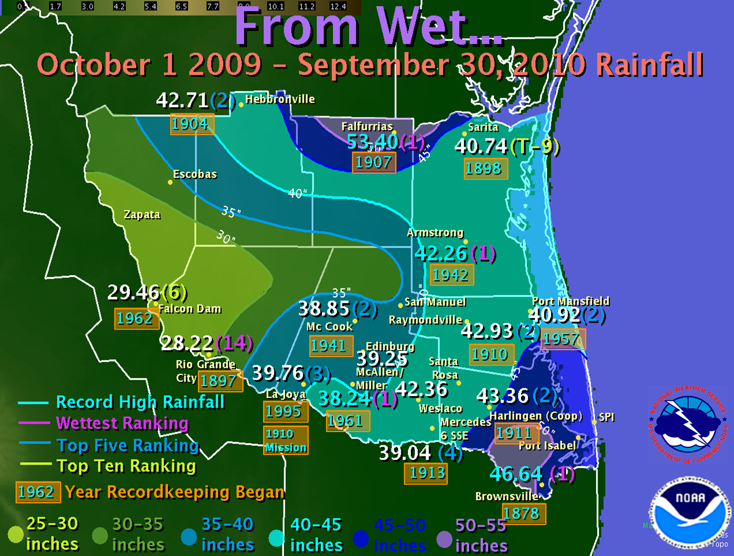
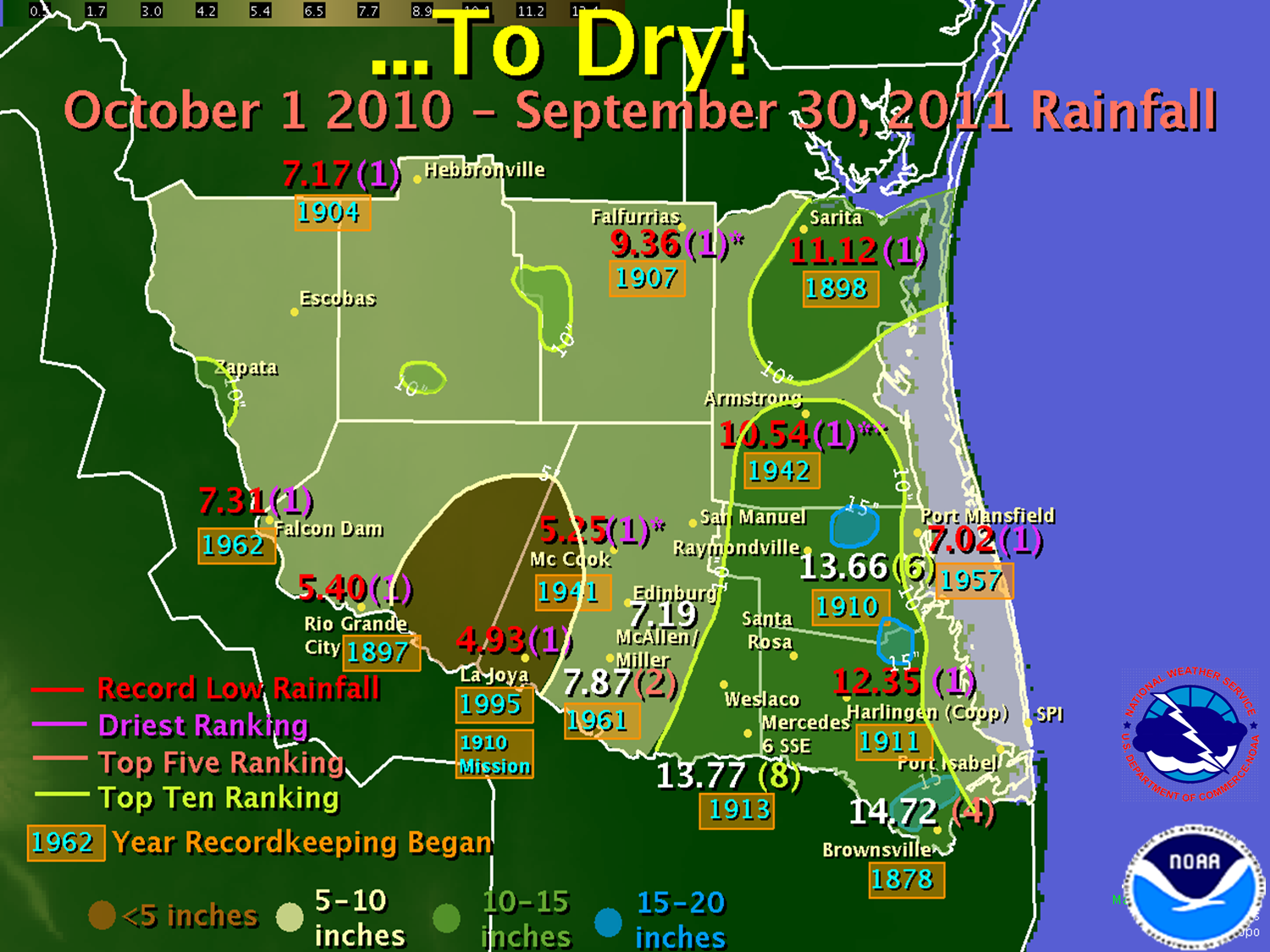
Table 1 shows the final water year rainfall totals, rankings, and departure from long term average (based on available years of record). Cutoff for missing data was set to 30 percent per year. Table 2 shows the September 2011 average temperature, rankings, and year records began. Cutoff for missing data was set to 30 percent per month. All data are preliminary and unofficial as of this writing.
2011 Water Year Rainfall (Oct. 1st 2010 to Sept. 30th 2011) Compared with Prior Records
|
Location
|
Rainfall
(Dry Rank)
|
Prior Record (year)
|
Departure from Average (in.)
|
|
La Joya/Mission
|
4.93 (1)
|
7.09 (1955/56)
|
15.51
|
|
McCook*
|
5.25 (1)
|
5.80 (1961/62)
|
16.27
|
|
Rio Grande City
|
5.40 (1)
|
5.51 (1901/02)
|
13.97
|
|
Port Mansfield
|
7.02 (1)
|
10.47 (2008/09)
|
18.81
|
|
Hebbronville
|
7.17 (1)
|
8.89 (1916/17)
|
14.29
|
|
Falcon Dam
|
7.31 (1)
|
10.25 (1979/80)
|
13.10
|
|
Falfurrias*
|
9.36 (1)
|
11.88 (1951/52)
|
15.08
|
|
Armstrong**
|
10.54 (1)
|
14.86 (1959/60)
|
15.66
|
|
Sarita 7 E
|
11.12 (1)
|
11.66 (2008/09)
|
15.73
|
|
Harlingen/Coop
|
12.35 (1)
|
12.67 (1961/62)
|
14.48
|
|
McAllen/Miller
|
7.87 (2)
|
7.27 (2008/09)
|
14.47
|
|
Brownsville
|
14.72 (4)
|
11.90 (1952/53)
|
10.95
|
|
Raymondville
|
13.66 (6)
|
10.38 (1917/18)
|
n/a
|
|
Mercedes 6 SSE
|
13.77 (8)
|
9.01 (1955/56)
|
10.50
|
*Missing ≥50 days
**Record has gap from 1979 until 2002
Table 2: Average Temperatures, September 2011 (preliminary data)
|
Station
|
2011 Average
|
Rank
|
All-Time Record
|
Year
|
|
McAllen/Miller Arpt. (since 1961)
|
87.73
|
1
|
86.65
|
2005
|
|
McAllen/Coop (since 1941)
|
87.6
|
1
|
87.1
|
2005
|
|
La Joya/Mission (since 1910)
|
87.0
|
1
|
86.5
|
2005
|
|
Edinburg (since 2000)
|
86.3
|
1
|
84.9
|
2005
|
|
Falcon Dam (since 1962)
|
86.1
|
2
|
87.0
|
2005
|
|
Hebbronville (since 1904)
|
84.1
|
2
|
84.5
|
2005
|
|
Port Mansfield (since 1958)
|
82.7
|
2
|
83.5
|
2005
|
|
Harlingen/Coop (since 1911)
|
84.6
|
3
|
85.0
|
1959
|
|
Mercedes 6 SSE (since 1913)
|
84.4
|
3
|
84.8
|
1920
|
|
Rio Grande City (since 1897)
|
85.4
|
7
|
87.0
|
1946
|
|
Brownsville (since 1878)
|
84.23
|
7
|
85.0
|
1900
|
|
McCook (since 1941)
|
83.9
|
8
|
85.6
|
2005
|
|
Armstrong* (since 1942)
|
82.0
|
8
|
88.0
|
1977
|
|
Raymondville (since 1910)
|
83.3
|
10
|
85.7
|
1947
|
|
Falfurrias (since 1907)
|
82.6
|
32
|
86.2
|
1926
|
*Record has gap from 1979 until 2002
|


 Follow us on YouTube