†Available data include only 41 years out of 100 possible; similarly warm years (1998, 1950) were missing.
‡Ranking moved from (6) to (5) based on missing cold season data (March and September)in 1920 *Missing 65 days in 2012 including 23 in November; effective ranking likely in top 5 warmest. "Hail" of a Warm Year 2012: Record Warmth, Persistent Drought, and Memorable Thunderstorms Tropical Cyclones Steer Clear of the Rio Grande Valley |
|||||||||||||||||||||||||||||||||||||||||||||||||||||||||||||
|
In Brief Continue reading for a capsule of the many weather stories through 2012. Links are provided to take you to the full details of each event. |
|||||||||||||||||||||||||||||||||||||||||||||||||||||||||||||
| January to March: Warm and Briefly Wet, Punctuated by a Massive Hailstorm | |||||||||||||||||||||||||||||||||||||||||||||||||||||||||||||
|
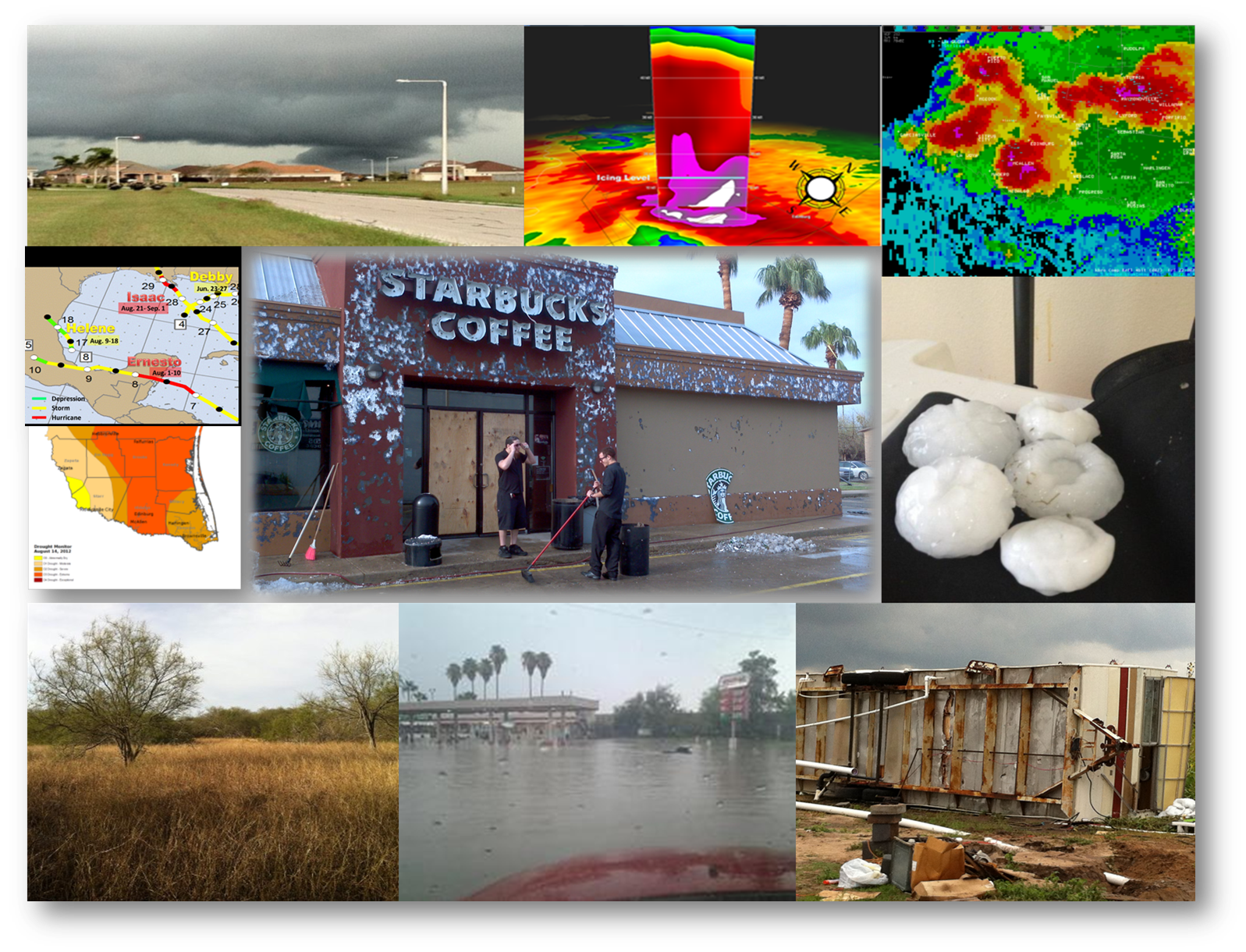
For many, 2012 began where 2011 left off: near–record warmth and very little rainfall in January. Several Valley locations finished among the top ten warmest, including Brownsville and McAllen. A cold front on February 4th produced torrential thunderstorms in the Lower Valley, and was followed by a series of upper level disturbances which brought drought denting rain and cooler than average temperatures to the region. Additional brief cool, wet spells were interspersed among very warm and humid days and nights in a February roller coaster which ended above average for temperature and rainfall; 3 to 5 inches of rain fell across the region. One might say March came in like a quiet lamb and exited like a roaring lion. Compared to February, March returned to warm form throughout the month, with temperatures rising to 3–5° above average. For the mid Valley, the heat was secondary to what would become the most memorable single event in 2012: An epic wind driven hailstorm on the 29th. Warm, humid surface air was lifted explosively by an approaching dryline and vigorous upper level energy through a very unstable atmosphere into late afternoon hailstorms, downburst winds, and even a tornado over the King Ranch. Outflow boundaries from these storms and additional cells in northeast Mexico converged on the McAllen/Edinburg/Mission/Pharr metropolitan area by mid evening. The result? A nearly stationary supercell thunderstorm laden with ice, water, and wind. Millions of hailstones up the size of baseballs driven by winds up to hurricane force for nearly an hour ripped through the area between 845 and 945 PM. Rainfall estimated between 4 and 6 inches caused widespread urban flooding, exacerbated by hail accumulation and drifts. The storm left an estimated $200 to $500 million in property damage across the area. The city of McAllen bore the brunt of damage; clean up continued through the rest of spring and into summer. |
|||||||||||||||||||||||||||||||||||||||||||||||||||||||||||||
| April to June: A Hail of a Time | |||||||||||||||||||||||||||||||||||||||||||||||||||||||||||||
|
"Thor’s Revenge" would best describe the remainder of spring 2012. A brief respite from dangerous storms to begin April would end on April 16th, when a weakening front moved into the Rio Grande Valley, producing torrential rains, gusty winds, and a little hail for the late afternoon commute. The event finished with a flourish on South Padre Island, where near hurricane force gusts caused minor property damage. The Monday event was a prelude to a bizzare finish to the work week. On Friday, April 20th, another crazy hailstorm sliced through the mid Valley. For the second time in three weeks, residents of the McAllen/Edinburg/Mission/Pharr metropolitan area dealt with very large hail up the size of a softball (or grapefruit) during the heart of the afternoon commute. Fortunately, the upper level system and attendant cold front raced through the region and arrived with ample dry air above the surface, which sharply reduced the amount of hail and rain that fell with individual storms. Additional damage from the hail was limited by the short duration, lower volume of hail, and lack of concurrent downburst winds. Severe weather took top billing for the second week of May. Four individual episodes, and one local event, occurred during the week of May 8th through 15th. The week featured an upper level disturbance which slowly traveled from the Gulf of California through the Sonora/Chihuahua region of Mexico through the 10th, then ultimately through central Texas on the 11th and 12th (click here for animation). This disturbance initially acted on a slowing cold front on May 8th, then continued to induce showers and thunderstorms on successive days (9th, 10th, 11th, and 12th) along the stationary front which floated along the Rio Grande. The McAllen/Edinburg/Mission/Pharr metropolitan region breathed a huge sigh of relief on May 8th. One of the most intense storms of the season raked the ranchlands of Hidalgo County, just 30 miles north. The storm slammed through with instaneous winds in excess of 100 mph, blinding rain, and large hail. Some of the more populated portions of Hidalgo County weren’t as lucky on the 9th, when evening storms formed along the stationary front and caused substantial damage to a colonia northeast of Edinburg, followed by a swath of heavy rain and hail which extended to Sebastian, near the Cameron/Willacy/Hidalgo County line. On May 10th, the stationary front briefly retreated northward into the South Texas Brush Country; the approaching upper level disturbance produced a tornado and windstorm outbreak across the Coastal Bend during the afternoon and evening. From this outbreak, a squall line developed and propagated into the Deep South Texas ranchlands and Rio Grande Plains around midnight on the 11th and weakened a bit while moving into the mid Valley; remnant boundaries induced several small rotating storms that moved through Cameron County during the predawn hours on the 11th; one storm dropped a brief tornado in San Benito. A summary can be found here. Finally, as the disturbance exited Texas on May 12th, remnant unstable air across the Lower Valley was triggered by a wind shift/dry line by mid afternoon, and another round of hailstorms swept through the Lower Valley. The fast moving storms produced penny to half dollar sized hail but caught residents by surprise; a number of drivers, now accustomed to Valley hail, quickly drove vehicles under gas station and car wash canopies, among other spots. One silver lining for all the tumult of May 8th through 15th was welcome rainfall across the region, which continued to be impacted by a lengthening drought. From the ranchlands to the coast, one to three inches fell, with pocket of 3 to more than four inches across the Rio Grande Plains (on May 10th/11th) and from northern Hidalgo through northern Cameron/Willacy County. On the 15th, a small hail and windstorm cruised through Harlingen and San Benito, ending the Valley’s severe weather season. Some reasons why spring 2012 was laden with damaging wind and hailstorms can be found here. June was largely uneventful as the upper level disturbances which provided the angel of rainfall and the devil of severe storms lifted north under an increasing dome of high pressure. That dome of high pressure would shift into the central Great Plains and mid Mississippi Valley for the final third of the month; drought worsened across the Nation's breadbasket. Meanwhile, northwest (dry) flow around the atmospheric ridge nullified the threat for tropical cyclones. Rainfall slid well below average for most of the region except for the corners of the Valley. On June 30th, repeating thunderstorms dropped up to 6 inches of flooding rain in Brownsville, with a separate batch of torrentail rains of up to five inches along the Rio Grande from Starr to Zapata County. The dry June would set the stage for another record to near record hot summer. To Page 2 |
|||||||||||||||||||||||||||||||||||||||||||||||||||||||||||||


 Follow us on YouTube