| Overview | Radar |
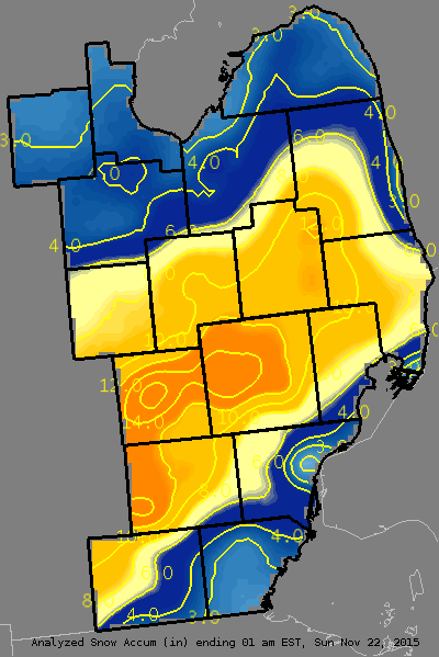
This winter season started off with a bang as a strong winter storm hit across the Plains and Midwest. Less than two days prior, Southeast Michigan saw temperatures in the 60 degree range before temperatures quickly cooled off back below freezing as the winter storm took hold. A strong area of low pressure took shape out on the central plains on Friday and strengthened as it moved east over the Mid-Mississippi River Valley. Snowfall reports of around 12 inches were reported over parts of southern Wisconsin and Northern Illinois. The system then took aim on Michigan, bringing with it 1"+ hour snowfall rates to portions of Southeast Michigan during the afternoon and early evening hours on Saturday. Washtenaw, Livingston, Oakland, and Genesee counties were the hardest hit in terms of total snowfall amounts ranging from 10 inches to over 16 inches. Howell, MI came in with the highest snowfall amount at 16.8! The NWS Detroit/Pontiac office in White Lake, MI measured 15.5" by the time the storm wrapped up which is the largest snowstorm the office has seen since it was built in 1994.
Back to top
Radar loop through 5 PM
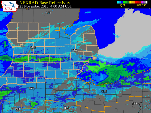 |
| Radar loop courtesy of Iowa Environmental Mesonet (IEM). |
|
|
PUBLIC INFORMATION STATEMENT...STORM TOTALS
NATIONAL WEATHER SERVICE DETROIT/PONTIAC MI
930 AM EST SUN NOV 22 2015

STORM TOTAL SNOW REPORTS

LOCATION                  SNOWFALL     DURATION
                          (INCHES)      (HOURS)        LAT       LON

...BAY COUNTY...
   BAY CITY                M   3.7           24     43.59N    83.89W

...GENESEE COUNTY...
   SWARTZ CREEK            M   9.5            M     42.96N    83.83W
   BURTON                  M   9.8           24     43.00N    83.62W
   GAINES                  M   9.8            M     42.87N    83.91W
   LINDEN                  M  10.0           24     42.82N    83.78W
   SE FLINT                M  10.4           25     43.02N    83.69W

...HURON COUNTY...
   5 NNW FILION            M   3.5           24     43.96N    83.04W

...LAPEER COUNTY...
   6 W LAPEER              M  10.5           14     43.05N    83.44W
   1 NW LUM                M  12.0           16     43.11N    83.17W

...LENAWEE COUNTY...
   MORENCI                 E   4.2           24     41.72N    84.22W
   2 WNW TIPTON            M   7.5           24     42.03N    84.10W
   ONSTED                  M   8.5           16     42.01N    84.19W
   2 SE CEMENT CITY        M  10.0           18     42.05N    84.30W

...LIVINGSTON COUNTY...
   BRIGHTON                M  11.5           14     42.53N    83.78W
   HARTLAND                M  14.0           16     42.66N    83.75W
   1 NE HOWELL             M  15.5           13     42.62N    83.92W
   HARTLAND                M  16.0            M     42.66N    83.75W
   HOWELL                  M  16.8           20     42.61N    83.94W

...MACOMB COUNTY...
   EASTPOINTE              M   4.5           14     42.47N    82.96W
   1 ENE ROSEVILLE         M   5.0           24     42.51N    82.92W
   4 ENE TROY              M   5.5           24     42.59N    83.07W
   CHESTERFIELD TOWNSHIP   M   6.0            M     42.68N    82.82W
   2 S ARMADA              M  10.0           15     42.81N    82.88W

...MIDLAND COUNTY...
   MIDLAND                 M   3.0            M     43.62N    84.23W
   OIL CITY                M   3.2           24     43.61N    84.59W

...MONROE COUNTY...
   DUNDEE                  M   3.0           24     41.96N    83.66W
   MONROE                  M   3.2            M     41.92N    83.39W
   3 SE NEWPORT            M   3.4           24     41.97N    83.27W

...OAKLAND COUNTY...
   ROYAL OAK               M   5.0           16     42.51N    83.15W
   FARMINGTON              M   6.4           16     42.46N    83.38W
   TROY                    M   7.0            M     42.58N    83.14W
   TROY                    M   8.0           16     42.58N    83.14W
   BLOOMFIELD HILLS        M   9.5           24     42.58N    83.25W
   BLOOMFIELD TOWNSHIP     M   9.5           24     42.57N    83.26W
   WATERFORD               M   9.7           24     42.66N    83.39W
   5 S CLARKSTON           M  11.5            M     42.66N    83.41W
   WIXOM                   M  11.8            M     42.52N    83.54W
   4 WNW WEST BLOOMFIELD   M  12.0           24     42.60N    83.45W
   5 N ROCHESTER HILLS     M  12.0            M     42.74N    83.16W
   ORTONVILLE              M  12.0           24     42.85N    83.44W
   1 E CLARKSTON           M  12.2           14     42.74N    83.40W
   LAKEVILLE               M  12.6           14     42.82N    83.15W
   HOLLY                   M  14.0           20     42.80N    83.62W
   MILFORD                 M  14.0            M     42.59N    83.60W
   4 SW CLARKSTON          M  15.5            M     42.69N    83.47W

...SAGINAW COUNTY...
   HEMLOCK                 M   4.0           24     43.42N    84.23W

...SANILAC COUNTY...
   LEXINGTON               M   3.0           24     43.27N    82.53W
   DECKERVILLE             M   7.0           24     43.53N    82.74W
   2 W PECK                M  12.0           21     43.26N    82.86W

...SHIAWASSEE COUNTY...
   2 E CORUNNA             M   8.0           24     42.98N    84.08W
   DURAND                  M   8.2           24     42.91N    83.99W

...ST. CLAIR COUNTY...
   HARSENS ISLAND          M   1.0            M     42.60N    82.58W
   3 WSW LAKEPORT          M   7.0           24     43.10N    82.55W
   YALE                    M   8.2           24     43.13N    82.80W

...TUSCOLA COUNTY...
   VASSAR                  M   4.0           24     43.37N    83.58W
   CASS CITY               M   4.1           24     43.60N    83.18W

...WASHTENAW COUNTY...
   3 SE ANN ARBOR          M   9.6           24     42.24N    83.69W
   2 NE ANN ARBOR          M  10.7           24     42.29N    83.71W
   5 N MANCHESTER          M  14.2           19     42.22N    84.04W

...WAYNE COUNTY...
   1 N GROSSE ILE          M   2.2           24     42.14N    83.15W
   SOUTHGATE               M   3.5           24     42.20N    83.21W
   WYANDOTTE               M   4.9           18     42.21N    83.16W
   ROMULUS                 M   6.0           18     42.22N    83.37W
   LIVONIA                 M   7.0            M     42.40N    83.37W
   GARDEN CITY             M   8.2           24     42.33N    83.33W


M = MEASURED
E = ESTIMATED
Back to top