| Overview | Radar |
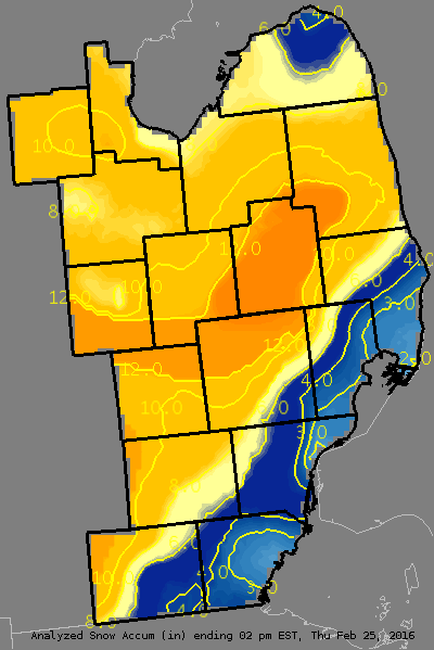
A strong low pressure system with copious moisutre moved northeastward from the Southern Plains to Lake Erie on February 24. Precipitation broke out across Southeast Michigan during the early morning hours of the 24th, spreading from south to north during the morning hours. Temperatures were marginal for snow, but it was cold enough for mainly snow north and west of the glacial ridge. To the south and east, including the city of Detroit, much of the precipitation fell as rain or a wintry mix, drastically reducing snowfall totals there. The snowfall was heavy at times during the afternoon and evening hours north of a line from roughly Ann Arbor to Port Huron, with 1" per hour rates common. The snowfall tapered off for a time overnight as the main precip shield was shunted to the west, but lingering moisture and forcing moved across Southeast Michigan once more during the morning hours of the 25th, adding a few more inches to storm totals.
All told, the heaviest amounts from 12 to 14" occurred in a stripe across Lapeer County, southern portions of Shiawassee and Genesee Counties, and northern portions of Oakland and Livingston Counties. At least 8" was common north and westof the glacial ridge. Lesser amounts of 2-4" occurred over the city of Detroit, with a tight gradient in snowfall in between.
Back to top
Radar loop
.gif) |
| Radar loop courtesy of Iowa Environmental Mesonet (IEM). |
|
|
PUBLIC INFORMATION STATEMENT...STORM TOTALS
NATIONAL WEATHER SERVICE DETROIT/PONTIAC MI
208 PM EST THU FEB 25 2016


STORM TOTAL SNOW REPORTS

LOCATION                  SNOWFALL     DURATION
                          (INCHES)      (HOURS)        LAT       LON

...BAY COUNTY...
   4 N BAY CITY            M   5.1           20     43.65N    83.89W
   PINCONNING              E   8.0           24     43.86N    83.96W
   2 NE AUBURN             M   8.6           27     43.62N    84.05W

...GENESEE COUNTY...
   GAINES                  M   9.5           24     42.87N    83.91W
   GOODRICH                M   9.7           22     42.92N    83.51W
   FLINT                   M   9.9           28     43.02N    83.69W
   1 W SWARTZ CREEK        M  10.5           23     42.96N    83.85W
   4 W GRAND BLANC         M  11.0           27     42.93N    83.71W
   DAVISON                 M  11.0           23     43.03N    83.52W
   4 N BURTON              M  11.9           22     43.05N    83.62W
   BURTON                  M  14.0           28     43.00N    83.62W

...HURON COUNTY...
   PORT AUSTIN             M   3.8           22     44.04N    83.00W
   BAD AXE                 M   6.0           21     43.80N    83.00W
   5 NNW FILION            M   7.2           20     43.96N    83.04W

...LAPEER COUNTY...
   4 E DAVISON             M  11.0           25     43.03N    83.44W
   LAPEER                  M  11.2           22     43.05N    83.32W
   COLUMBIAVILLE           M  13.0           24     43.16N    83.41W
   LAPEER                  M  13.0           24     43.05N    83.32W
   2 W LAPEER              M  13.7           24     43.05N    83.36W

...LENAWEE COUNTY...
   TECUMSEH                M   3.5           26     42.01N    83.94W
   5 NE ADRIAN             M   4.2           25     41.95N    83.97W
   ADRIAN                  M   5.0           27     41.90N    84.04W
   MORENCI                 M   6.5           25     41.72N    84.22W
   2 WNW TIPTON            M   9.2           26     42.03N    84.10W

...LIVINGSTON COUNTY...
   1 NW SOUTH LYON         M   6.2           22     42.47N    83.67W
   BRIGHTON                M   8.0           24     42.53N    83.78W
   1 N WHITMORE LAKE       M   8.3           23     42.44N    83.75W
   GREGORY                 M   8.8           25     42.46N    84.08W
   3 NW PINCKNEY           M   9.3           24     42.49N    83.99W
   HOWELL                  M  10.0           25     42.61N    83.94W
   2 ESE HOWELL            M  11.0           27     42.60N    83.90W
   HARTLAND                M  13.0           28     42.66N    83.75W

...MACOMB COUNTY...
   ROSEVILLE               M   1.5           27     42.51N    82.94W
   NEW BALTIMORE           M   2.5           23     42.68N    82.74W
   RICHMOND                M   3.1           25     42.81N    82.75W
   UTICA                   M   4.0           24     42.63N    83.02W
   ARMADA                  E   5.0           28     42.84N    82.88W
   SHELBY TOWNSHIP         M   6.0           24     42.67N    83.03W
   ROMEO                   E   8.0           29     42.80N    83.01W

...MIDLAND COUNTY...
   OIL CITY                M   9.0           19     43.61N    84.59W
   2 SSW MIDLAND           M   9.1           21     43.60N    84.24W
   MIDLAND                 M  10.0           26     43.62N    84.23W
   2 SSW MIDLAND           M  10.5           24     43.60N    84.24W
   SANFORD                 M  11.0           18     43.68N    84.38W

...MONROE COUNTY...
   MONROE                  M   2.0           28     41.92N    83.39W
   3 SE NEWPORT            M   2.1           26     41.97N    83.27W
   DUNDEE                  M   4.0           27     41.96N    83.66W

...OAKLAND COUNTY...
   1 S ROYAL OAK           M   3.0           23     42.49N    83.15W
   3 ENE NORTHVILLE        M   5.5           24     42.45N    83.43W
   2 WNW FARMINGTON HILLS  M   6.0           23     42.50N    83.41W
   FARMINGTON HILLS        M   6.0           27     42.49N    83.38W
   WEST BLOOMFIELD         M   6.0           26     42.57N    83.38W
   2 NW WATERFORD          M   8.8           22     42.68N    83.42W
   3 E MILFORD             M   9.8           24     42.59N    83.54W
   OXFORD                  M  10.0           22     42.82N    83.25W
   2 S ORTONVILLE          M  10.6           24     42.82N    83.44W
   3 E MILFORD             M  10.9           29     42.59N    83.54W
   CLARKSTON               M  11.0           28     42.74N    83.42W
   2 S LAKEVILLE           M  11.5           28     42.79N    83.15W
   4 E WHITE LAKE          M  11.7           29     42.65N    83.43W
   2 NNE WIXOM             M  12.0           28     42.55N    83.52W
   4 S HOLLY               M  12.0           25     42.74N    83.63W
   HIGHLAND                E  12.0           28     42.64N    83.62W
   LAKE ORION              M  12.4           29     42.78N    83.24W

...SAGINAW COUNTY...
   5 W CHESANING           M   7.0           23     43.17N    84.23W
   5 S MERRILL             M   7.5           23     43.34N    84.34W
   HEMLOCK                 M   7.5           21     43.42N    84.23W
   CHESANING               M   7.8           21     43.18N    84.12W
   1 S BIRCH RUN           M   8.3           23     43.24N    83.79W

...SANILAC COUNTY...
   LEXINGTON               M   9.5           21     43.27N    82.53W
   SANDUSKY                M  10.0           23     43.42N    82.83W
   2 W PECK                M  13.0           24     43.26N    82.86W
   2 W PECK                M  14.1           29     43.26N    82.86W

...SHIAWASSEE COUNTY...
   2 NE CORUNNA            M   7.5           20     43.00N    84.09W
   OWOSSO                  M   7.6           21     43.00N    84.18W
   6 WNW DURAND            M  10.2           22     42.95N    84.10W
   PERRY                   M  12.8           23     42.82N    84.23W
   3 SW PERRY              M  13.4           25     42.79N    84.27W

...ST. CLAIR COUNTY...
   ALGONAC                 M   2.0           24     42.62N    82.53W
   2 W PORT HURON          M   3.1           23     42.99N    82.47W
   COLUMBUS                M   4.0           23     42.89N    82.67W
   YALE                    M   9.4           24     43.13N    82.80W
   CAPAC                   M  10.0           29     43.01N    82.93W

...TUSCOLA COUNTY...
   CARO                    M   9.0           22     43.49N    83.40W
   VASSAR                  M   9.0           21     43.37N    83.58W
   KINGSTON                M  12.0           23     43.41N    83.19W

...WASHTENAW COUNTY...
   SALINE                  M   5.0           26     42.18N    83.78W
   3 SE ANN ARBOR          M   6.7           24     42.24N    83.69W
   SE ANN ARBOR            M   7.3           24     42.28N    83.73W
   2 WNW ANN ARBOR         M   8.0           25     42.29N    83.77W
   5 W PLYMOUTH            M   8.9           24     42.37N    83.57W
   ANN ARBOR               M   9.6           28     42.28N    83.73W
   5 NNW CHELSEA           E  10.0           25     42.38N    84.07W
   LYNDON TOWNSHIP         M  13.0           28     42.38N    84.07W

...WAYNE COUNTY...
   3 E DOWNTOWN DETROIT    M   1.0           26     42.34N    82.98W
   2 N GROSSE ILE          M   1.6           26     42.16N    83.15W
   GROSSE POINTE FARMS     M   2.0           26     42.40N    82.89W
   2 NE LIVONIA            M   4.0           25     42.42N    83.34W
   WYANDOTTE               M   4.4           31     42.21N    83.16W
   BROWNSTOWN TOWNSHIP     M   4.5           28     42.15N    83.26W
   GARDEN CITY             M   4.8           26     42.33N    83.33W
   DETROIT                 M   5.2           31     42.38N    83.11W
   2 NNW LIVONIA           M   6.1           25     42.42N    83.39W
   NORTHVILLE              M   8.0           27     42.44N    83.49W
   PLYMOUTH                M   9.0           30     42.37N    83.47W


M = MEASURED
E = ESTIMATED

$$
Back to top

