Scattered showers and thunderstorms developed during the mid-afternoon hours of Saturday, July 10th, and moved eastward throughout the evening. As the evening progressed, these storms formed into a linear structure which propagated eastward through the Sioux Falls area and into southwest Minnesota. Rainfall totals from this event ranged from an inch and a half to trace amounts throughout the region. The image and table below summarize the 24 hour precipitation totals from selected locations throughout the area.
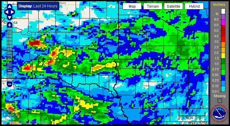
The image above represents a multi-sensor precipitation estimation which is a product of the River Forecast Center. It makes use of rain gauge data, as well as radar estimated rainfall totals, to create a gridded estimation of rainfall totals across the area.
Listed below are selected rainfall totals from reporting stations across the area:
| Location | Rainfall |
| 11 S White Lake | 1.50" |
| White Lake | 1.40" |
| 7 WSW Parker | 1.37" |
| Artichoke Lake | 1.00" |
| 3 ESE Sioux Falls | 0.91" |
| Custer | 0.87" |
| Lakefield, MN | 0.78" |
| Marshall, MN | 0.77" |
| Marion | 0.74" |
| Sheldon, IA | 0.58" |
| Orange City, IA | 0.51" |
| Sheldon, IA | 0.51" |
| Brookings | 0.50" |
| 4 WNW Sioux Falls | 0.42" |
| Sioux Falls WFO | 0.41" |
| Worthington, MN | 0.39" |
| Hartford | 0.37" |
| Sioux Falls Airport | 0.35" |
| Windom, MN | 0.34" |
| Pipestone, MN | 0.30" |
| Sibley, IA | 0.30" |


 Weather Story
 Weather Map
 Local Radar