Overview
|
A winter storm brought widespread snow across the region from Friday morning November 28th to late Saturday night November 29th, 2025. Light snow spread in through the day Friday from the west. A lull in snow overnight brought a light coating of freezing drizzle, and snow reinvigorated Saturday and Saturday night with flurries continuing into Sunday. Post-Thanksgiving travel was impacted greatest on Saturday with the poorest conditions developing with patchy blowing and drifting snow Saturday night as winds gusted in the 20s and 30s. |
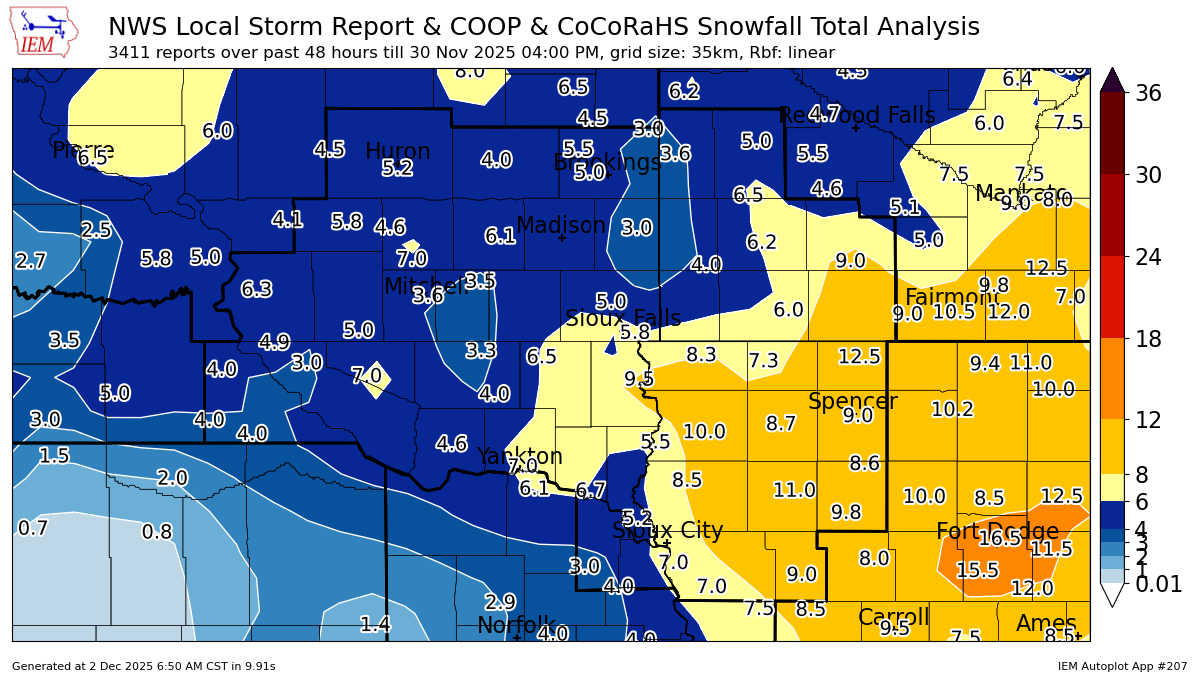 Map of snowfall reports from November 28-30, 2025. |
Snow/Ice
...STORM TOTAL SNOWFALL REPORTS, ENDING SUNDAY NOVEMBER 30TH, 2025...

Location                     Amount    Time/Date       Provider

...Iowa...

...Buena Vista County...
Storm Lake                   9.8 in    0800 AM 11/30   CO-OP Observer

...Cherokee County...
1 ENE Cherokee               11.0 in   0800 AM 11/30   CO-OP Observer

...Clay County...
2 SE Spencer                 9.0 in    0220 PM 11/29   Public

...Dickinson County...
0.6 E Spirit Lake            12.5 in   0700 AM 11/30   COOP
1 NW Wahpeton                11.5 in   0800 AM 11/30   CO-OP Observer
3 SSE Lake Park              8.2 in    0700 AM 11/30   CO-OP Observer

...Ida County...
Battle Creek                 9.0 in    0830 AM 11/30   Public
1 WSW Ida Grove              9.0 in    0845 AM 11/30   Trained Spotter

...Lyon County...
Rock Rapids                  8.3 in    0800 AM 11/30   CO-OP Observer

...O'Brien County...
Primghar                     8.7 in    0400 PM 11/30   CO-OP Observer
Sanborn                      8.6 in    0800 AM 11/30   CO-OP Observer
Sheldon                      8.5 in    0550 PM 11/29   Public

...Osceola County...
Sibley                       7.3 in    0900 AM 11/30   COOP

...Plymouth County...
Le Mars                      6.3 in    1100 AM 11/30   Public
Remsen                       5.8 in    1115 AM 11/30   COOP

...Sioux County...
2 SSE Sioux Center           7.0 in    0300 PM 11/30   CO-OP Observer
Orange City                  6.7 in    0700 AM 11/30   CO-OP Observer
Hawarden                     5.5 in    1200 PM 11/30   Public

...Woodbury County...
Sergeant Bluff               7.0 in    0600 AM 11/30   Official NWS Obs
3.4 N Hornick                7.0 in    0700 AM 11/30   COOP

...Minnesota...

...Cottonwood County...
2.6 NW Windom                9.0 in    0800 AM 11/30   COOP

...Lincoln County...
Hendricks 8.0 SE             3.6 in    0700 AM 11/30   COCORAHS

...Lyon County...
Marshall                     5.0 in    0800 AM 11/30   COOP
5 S Cottonwood               4.7 in    0821 AM 11/30   COCORAHS
Milroy 4.1 SSW               4.0 in    0700 AM 11/30   COCORAHS

...Murray County...
Slayton 0.8 SSW              6.2 in    0700 AM 11/30   COCORAHS

...Nobles County...
Worthington 2 NNE            6.0 in    0700 AM 11/30   COOP

...Pipestone County...
Edgerton 0.2 WSW             4.0 in    0700 AM 11/30   COCORAHS

...Rock County...
Hills 0.2 NW                 6.5 in    0700 AM 11/30   COCORAHS

...Nebraska...

...Dakota County...
Emerson                      4.0 in    0900 PM 11/30   CO-OP Observer

...South Dakota...

...Aurora County...
Stickney 3.8 SW              5.0 in    0700 AM 11/30   COCORAHS

...Beadle County...
2 S Huron                    5.2 in    0600 AM 11/30   Official NWS Obs

...Bon Homme County...
Tyndall                      4.6 in    0700 AM 11/30   COOP

...Brookings County...
Volga                        5.0 in    0651 AM 11/30   Trained Spotter
2 NE Brookings               3.4 in    0800 AM 11/30   CO-OP Observer
Astoria 2.2 SSE              3.0 in    0700 AM 11/30   COCORAHS

...Brule County...
Pukwana 1.9 S                6.3 in    0700 AM 11/30   COCORAHS
Chamberlain 7.5 SSW          5.0 in    0700 AM 11/30   COCORAHS

...Charles Mix County...
Academy 2 NE                 4.9 in    0900 AM 11/30   CO-OP Observer

...Clay County...
Vermillion 1 SSE             6.7 in    1245 PM 11/30   CO-OP Observer

...Davison County...
1 SE Mitchell                3.6 in    1054 PM 11/29   CO-OP Observer

...Douglas County...
Dimock 10.2 W                3.1 in    0700 AM 11/30   COCORAHS

...Gregory County...
5 SSW Herrick                4.0 in    0700 AM 11/30   Cocorahs
Dallas 8.8 S                 4.0 in    0700 AM 11/30   COCORAHS

...Hutchinson County...
Emery 10.8 S                 3.3 in    0600 AM 11/30   COCORAHS

...Jerauld County...
Wessington Springs           5.8 in    1113 PM 11/29   Emergency Mngr

...Kingsbury County...
De Smet 0.2 SSE              4.0 in    0700 AM 11/30   COCORAHS

...Lincoln County...
Canton                       9.5 in    0700 AM 11/30   COOP
Harrisburg 0.8 NNE           5.4 in    0700 AM 11/30   COCORAHS

...McCook County...
Parker 7.2 N                 6.0 in    0700 AM 11/30   COCORAHS
Montrose 5.8 NW              4.5 in    0700 AM 11/30   COCORAHS

...Miner County...
Howard                       6.1 in    0903 AM 11/30   COOP

...Minnehaha County...
4 WNW Rowena                 5.8 in    0634 PM 11/29   NWS Employee
Renner 4.1 NW                5.0 in    0700 AM 11/30   COCORAHS
3 N Sioux Falls              4.8 in    0600 AM 11/30   Official NWS Obs

...Moody County...
Colman 10.6 N                3.5 in    0700 AM 11/30   COCORAHS

...Sanborn County...
Letcher 0.5 E                7.0 in    0700 AM 11/30   COCORAHS

...Turner County...
Marion                       6.5 in    0700 AM 11/30   CO-OP Observer

...Union County...
Jefferson 2.1 WNW            5.2 in    0700 AM 11/30   COCORAHS

...Yankton County...
Yankton 1.0 ESE              7.0 in    0800 AM 11/30   COCORAHS

Observations are collected from a variety of sources with varying
equipment and exposures. We thank all volunteer weather observers
for their dedication. Not all data listed are considered official.

$$
Radar
 |
| Base radar reflectivity loop from 2:00 AM Friday November 28th to 10:30 PM Saturday November 29th, 2025 |
Additional Information
The Forecast
 |
 |
| Winter Storm Watch | Winter Storm Warning and Winter Weather Advisory |
 |
Media use of NWS Web News Stories is encouraged! Please acknowledge the NWS as the source of any news information accessed from this site. |
|


 Weather Story
 Weather Map
 Local Radar