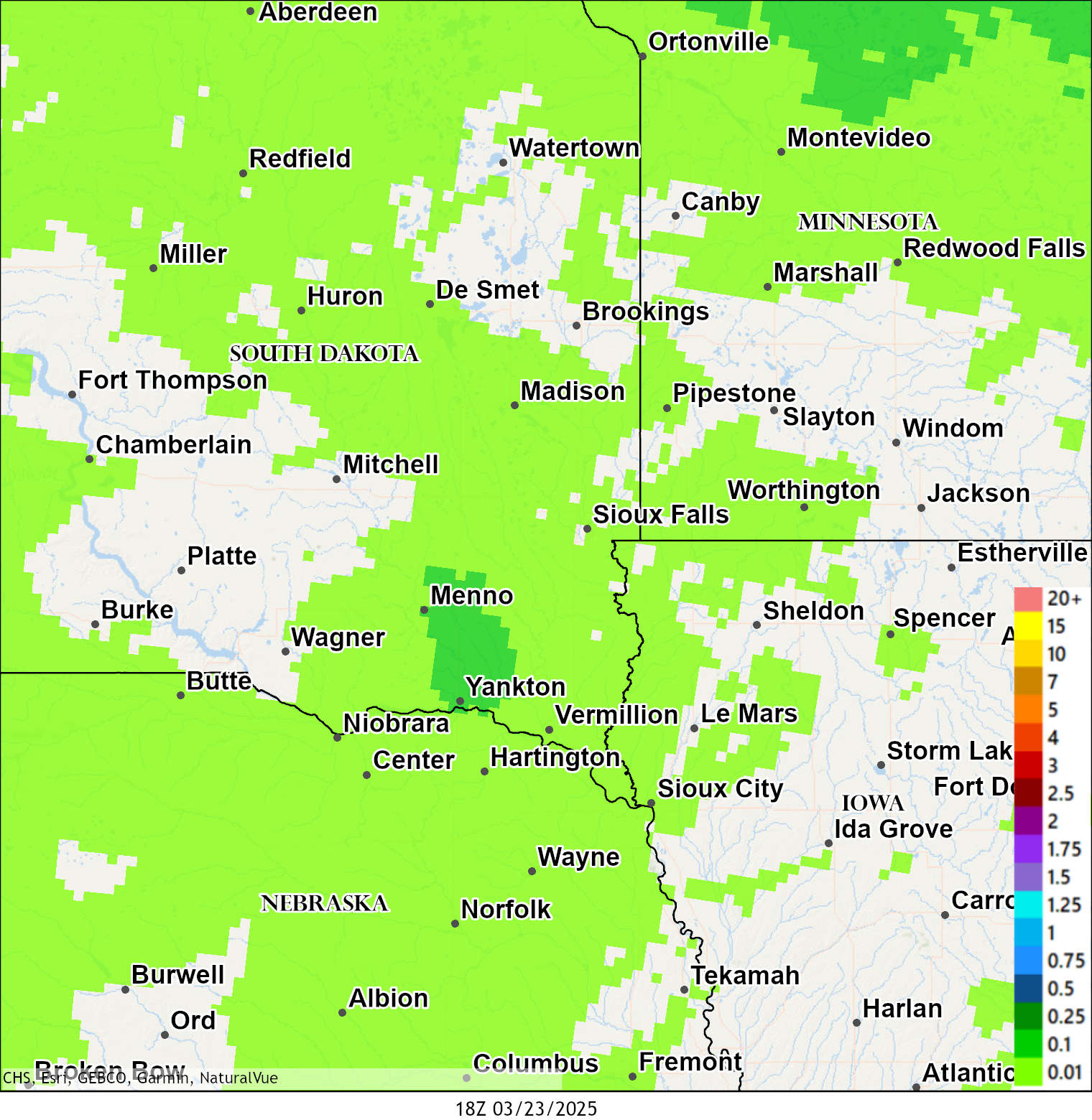
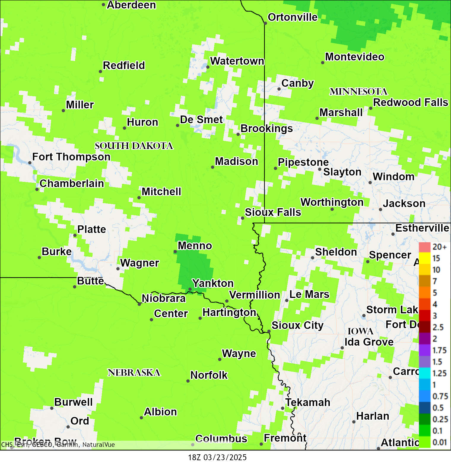
Maps of Observed Precipitation Across Southeast South Dakota,
Southwest Minnesota, Northwest Iowa, and Extreme Northeast Nebraska
 |
 |
 |
| 24 Hour Precipitation |
48 Hour Precipitation |
72 Hour Precipitation |
Maps are created by the Missouri Basin River Forecast Center and are updated daily around 9:30am, 11:30am, and 1:30 pm
Additional sources for temperature and precipitation data, as well as a text listing of precipitation reports from CoCoRaHS locations are included below.
Interactive maps of snowfall and snow depth are available from the following sources:
Snowfall -- Snow Depth |
| Additional Data Sources |
|
CoCoRaHS Reports |
|
WFO local products providing the data contained in the discontinued RTP product at individual locations include:
Text Products for daily summaries of temperatures and precipitation from which the RTP was constructed.
Alternative websites providing the data contained in the RTP product at individual locations include:
Alternative website providing the data contained in the RTP product with option to access data at multiple locations:
As part of this webpage, SC ACIS is available to access data from multiple stations for a specific date at one time:
|
|
428
SXUS53 KFSD 021416
LCOFSD

COCORAHS PRECIPITATION SUMMARY
NATIONAL WEATHER SERVICE SIOUX FALLS SD
1015 AM CDT SUN AUG 02 2026

COCORAHS PRECIPITATION REPORTS
THESE REPORTS ARE CONSIDERED SUPPLEMENTAL AND UNOFFICIAL
VALUES ARE FOR THE PREVIOUS 24 HOURS ENDING AROUND 7 AM LOCAL TIME


:COCORAHS PRECIPITATION REPORTS IN SOUTHEASTERN SOUTH DAKOTA

:                                                   SNOW   SNOW  WATER
:                                            PCPN   FALL  DEPTH  EQUIV

SD-YN-26    : YANKTON 9.1 W            *   : 0.00 / 0.0 /   MM /   MM
SD-UN-11    : JEFFERSON 2.1 WNW        *   : 0.00 / 0.0 /   MM /   MM
SD-SB-04    : LETCHER 0.5 E            *   : 0.00 / 0.0 /   MM /   MM
SD-SB-02    : FORESTBURG 0.1 NE        *   : 0.00 / 0.0 /   MM /   MM
SD-MH-147   : SIOUX FALLS 1.1 SSE      *   : 0.00 / 0.0 /   MM /   MM
SD-MH-113   : GARRETSON 5.5 W          *   : 0.00 / 0.0 /    0 / 0.00
SD-MH-105   : SIOUX FALLS 1.6 SW       *   : 0.00 / 0.0 /   MM /   MM
SD-MH-96    : SIOUX FALLS 3.3 E        *   : 0.00 / 0.0 /   MM /   MM
SD-MH-92    : SIOUX FALLS 5.5 N        *   : 0.00 / 0.0 /   MM /   MM
SD-MH-91    : GARRETSON 1.7 WSW        *   : 0.00 / 0.0 /   MM /   MM
SD-MH-46    : HARTFORD 0.5 N           *   : 0.00 / 0.0 /   MM /   MM
SD-MH-01    : SIOUX FALLS 5.0 SE ARPT  *   : 0.00 / 0.0 /    0 /   MM
SD-MC-13    : PARKER 7.2 N             *   : 0.00 / 0.0 /   MM /   MM
SD-MC-01    : MONTROSE 5.8 NW          *   : 0.00 / 0.0 /   MM /   MM
SD-LN-34    : HARRISBURG 0.8 NNE       *   : 0.00 / 0.0 /   MM /   MM
SD-LN-12    : LENNOX 3.3 NE            *   : 0.00 / 0.0 /   MM /   MM
SD-KY-05    : DE SMET 0.2 SSE          *   : 0.00 / 0.0 /   MM /   MM
SD-HT-16    : EMERY 10.8 S             *   : 0.00 / 0.0 /   MM /   MM
SD-GY-01    : DALLAS 8.8 S             *   : 0.00 / 0.0 /   MM /   MM
SD-BL-10    : CHAMBERLAIN 7.5 SSW      *   : 0.00 / 0.0 /   MM /   MM
SD-BK-69    : BROOKINGS 0.4 WNW        *   : 0.00 / 0.0 /   MM /   MM
SD-BK-56    : BROOKINGS 6.5 NNW        *   : 0.00 / 0.0 /   MM /   MM
SD-BK-54    : BROOKINGS 1.4 NW         *   : 0.00 / 0.0 /   MM /   MM
SD-BK-07    : BROOKINGS 0.2 SSW        *   : 0.00 / 0.0 /   MM /   MM
SD-BK-03    : BROOKINGS 1.4 SW         *   : 0.00 / 0.0 /   MM /   MM

:COCORAHS PRECIPITATION REPORTS IN NORTHWESTERN IOWA

:                                                   SNOW   SNOW  WATER
:                                            PCPN   FALL  DEPTH  EQUIV

IA-SX-12    : ORANGE CITY 0.4 NNE      *   : 0.00 / 0.0 /   MM /   MM
IA-PL-09    : LE MARS 1.0 E            *   : 0.00 / 0.0 /   MM /   MM
IA-ID-04    : ARTHUR 3.7 SSW           *   : 0.00 / 0.0 /   MM /   MM
IA-DK-15    : MILFORD 1.4 NNE          *   : 0.00 / 0.0 /   MM /   MM
IA-DK-12    : MILFORD 1.0 SSE          *   : 0.00 / 0.0 /   MM /   MM
IA-DK-06    : LAKE PARK 0.2 N          *   : 0.00 / 0.0 /   MM /   MM
IA-CK-08    : CHEROKEE 4.5 NNW         *   : 0.00 / 0.0 /   MM /   MM

:COCORAHS PRECIPITATION REPORTS IN SOUTHWESTERN MINNESOTA

:                                                   SNOW   SNOW  WATER
:                                            PCPN   FALL  DEPTH  EQUIV

MN-RK-05    : HILLS 0.2 NW             *   : 0.00 / 0.0 /   MM /   MM
MN-PS-06    : EDGERTON 0.2 WSW         *   : 0.00 / 0.0 /   MM /   MM
MN-NB-11    : BREWSTER 0.1 SW          *   : 0.00 / 0.0 /   MM /   MM
MN-NB-10    : BIGELOW 1.8 NW           *   : 0.00 / 0.0 /   MM /   MM
MN-NB-08    : WORTHINGTON 4.0 S        *   : 0.00 / 0.0 /   MM /   MM
MN-NB-07    : WORTHINGTON 1.9 SW       *   : 0.00 / 0.0 /   MM /   MM
MN-MY-13    : CHANDLER 2.7 SSE         *   : 0.00 / 0.0 /   MM /   MM
MN-MY-11    : SLAYTON 0.8 SSW          *   : 0.00 / 0.0 /   MM /   MM
MN-LN-10    : LAKE BENTON 4.0 NNE      *   : 0.00 / 0.0 /   MM /   MM
MN-CD-08    : MOUNTAIN LAKE 0.4 WNW    *   : 0.00 / 0.0 /   MM /   MM

:COCORAHS PRECIPITATION REPORTS IN NORTHEASTERN NEBRASKA

:                                                   SNOW   SNOW  WATER
:                                            PCPN   FALL  DEPTH  EQUIV

:NO REPORTS FOUND...


$$
|
These data are preliminary and have not undergone final quality control by the National Centers for Environmental Information (NCEI). Therefore, these data are subject to revision. Final and certified climate data can be accessed at the NCEI - https://www.ncei.noaa.gov
Additional Data Sources:


 Weather Story
 Weather Map
 Local Radar