 |
 |
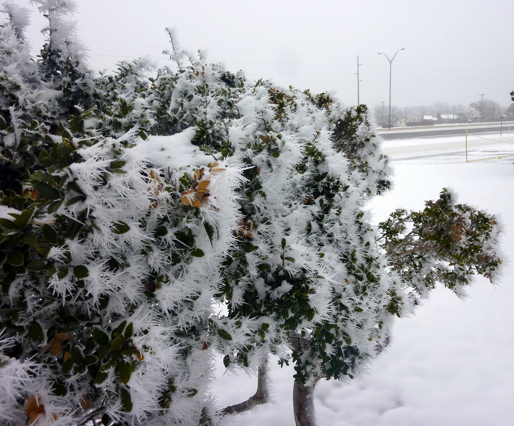
| Much of the South Plains woke up Sunday morning to a pretty sight as freezing fog produced rime ice which covered much of the vegetation. |
| |
| A couple of passing upper level disturbances brought two distinct rounds of snow to West Texas in late February. After the accumulating snow came to an end, very cold air lingered in the region into early March, and when combined with plenty of low-level moisture, it produced persistent cloud cover and prolonged periods of freezing fog. The freezing fog kept roadways hazardous, but significant riming deposits, like the one shown above, did create a beautiful and eerie winter wonderland. |
| |
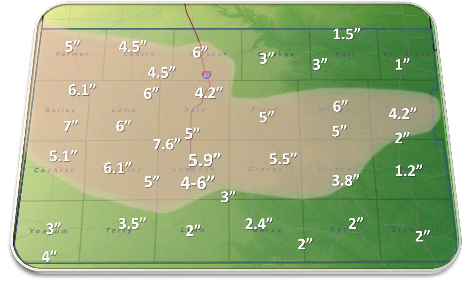 |
| Snowfall totals for the 3-day period from Feb 26 to 28, 2015. NWS Co-op observers provided most of the reports. Click on the image to view a larger version. |
| |
|
As the above graphic shows, the two rounds of snow (from February 26 - 28, 2015) did produce fairly impressive snow totals for much of the South Plains region. The highest totals, from 4 to 6+ inches, generally fell in a swath from the southwest Texas Panhandle through much of the central and northern South Plains and into the northern Rolling Plains. Officially, the Lubbock International Airport recorded 5.9 inches over a two-day stretch (1.3" on the 26th; and 4.6" on the 27th). Impressively, the 4.6 inches of snow that fell on the 27th was the 35th largest single-day snowfall ever recorded at Lubbock going back to the beginning of records in 1911.
|
| |
 |
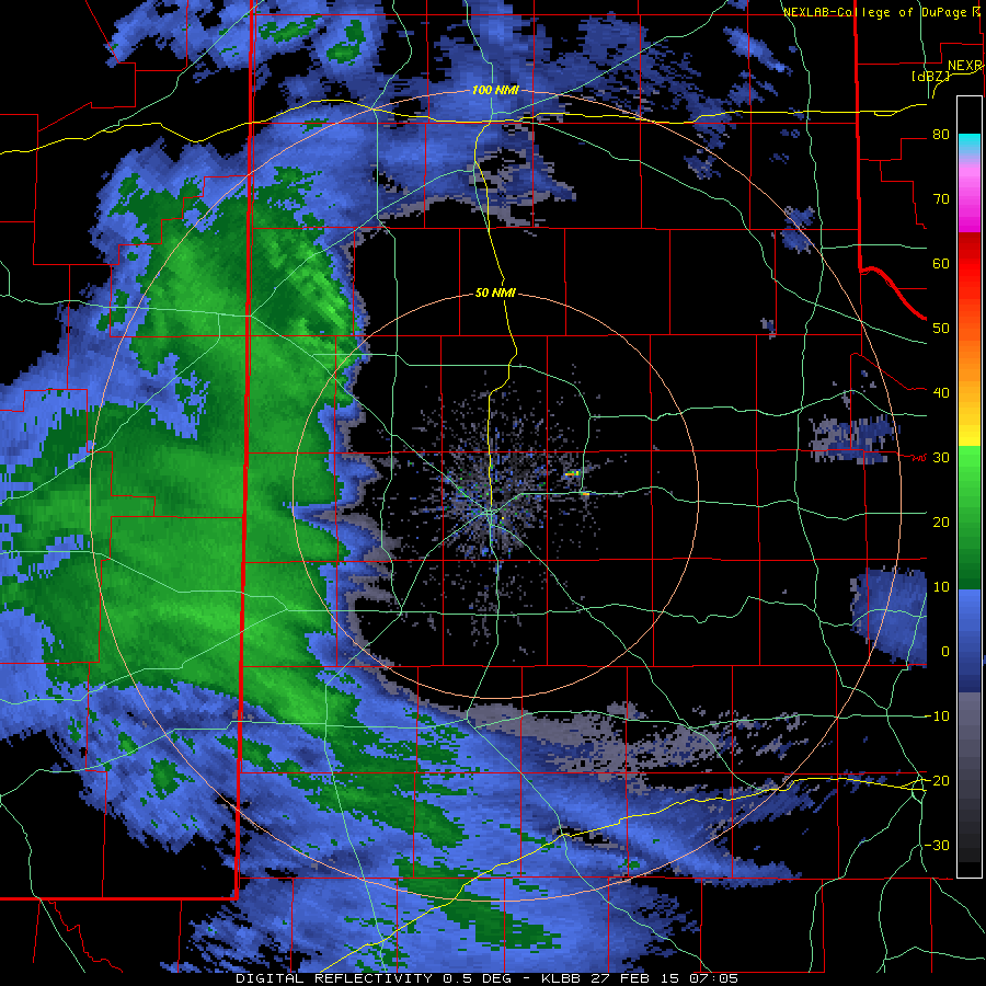
| Regional radar animation valid from 2:38 am to 3:48 am CST on Thursday, February 26, 2015. An additional radar animation valid from 5:48 am to 6:58 am CST on Thursday, February 26, 2015 can be VIEWED HERE. |
| |
| The first wave of wintry weather affected the region late on the Wednesday into Thursday morning (25-26 February). A sharp upper level disturbance dropping southeastward from the Rockies generated a band of precipitation that swept across the area (see the above radar animation). Initially, temperatures were warm enough for a cold rain, but as colder air infiltrated the region, the rain quickly changed to snow. Many locations, including in Lubbock, saw a quick inch or two of snow before the accumulating snow quickly tapered off by Thursday afternoon. |
| |
 |
| Lubbock radar loop valid from 1:05 am to 10:48 am CST on Friday, January 27, 2015. |
| |
| Frigid air then continued to pour into northwest Texas late on Thursday and remained entrenched on through the weekend. Additionally, a second even stronger upper level storm system raced toward the region late Thursday night and passed overhead through Friday morning. The system caused precipitation to blossom late Thursday night as it spread eastward over the entire region (see the above radar animation). By this time, temperatures throughout the depth of the atmosphere were plenty cold so that all the precipitation fell as snow, which came down heavy at times. Many locations recorded 2-5 inches of snow with this second round, with localized higher amounts. To add insult to injury, temperatures were only in the teens, which resulted in wind chills down around zero. |
| |
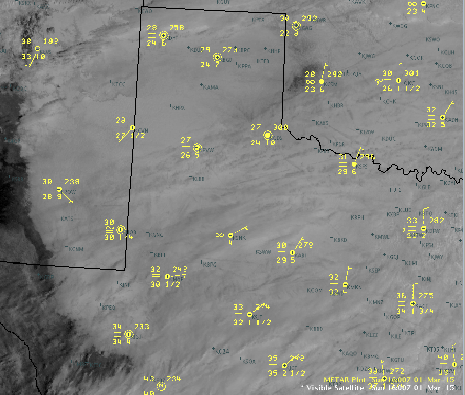 |
| A visible satellite image of the West Texas region from 11 am on Sunday, March 1st. The top number represents the temperature and the bottom number is the dewpoint. The horizontal lines indicate fog at the observation site. Click on the image to enlarge. |
| |
| Cloudy skies persisted on through the weekend, and this kept temperatures from moderating very quickly. In fact, after falling below freezing early on February 26th, most spots did not see the mercury eclipse the 32 degree mark until late on March 1st or not until March 2nd. The prolonged period of sub-freezing temperatures did result in numerous problems with frozen pipes, and many poorly insulated buildings sustained damage. Moreover, the cold and moist conditions kept freezing fog roaming the region, and this did result in significant riming. The riming kept roadways hazardous, but it also produced some amazing (and rare) scenes. |
| |
 |
| A graph of daily temperatures at the Lubbock Airport from February 2015. Click on the image to view a larger version. |
| |
| As a whole, the month of February 2015 brought quite a range of weather, as is common for this time of year. Much of the first two-thirds of month saw temperatures near or above long-term averages. However, two sharply colder slugs of air did move in toward the end of the month, as the above graph shows. Overall, February finished 0.9 degrees below normal, primarily due to the cold ending. In fact, temperatures in February for Lubbock were slightly above average until the final day, when the daily average was only 19 degrees (normal is 48 degrees). The moisture from the snow also helped boost precipitation totals for the month, after a relatively dry beginning and middle of February. Officially, Lubbock recorded 0.66 inches of liquid equivalent (and 6.5 inches of snow) in February, which finished just 0.09 inches below the monthly average. |
| |
 |
 |
 |
 |
| Some more views of incredible riming on the trees in Lubbock on March 1, 2015. The top two photos are courtesy Jennifer Daniel, the bottom two were taken at our office. Click on the images for more detailed views. |
| |
| The snow and freezing fog (riming) brought many interesting and rare sights to a region that often experiences rather arid and mild winters. Above and below are a few very good examples of the type of riming that took place. |
| |
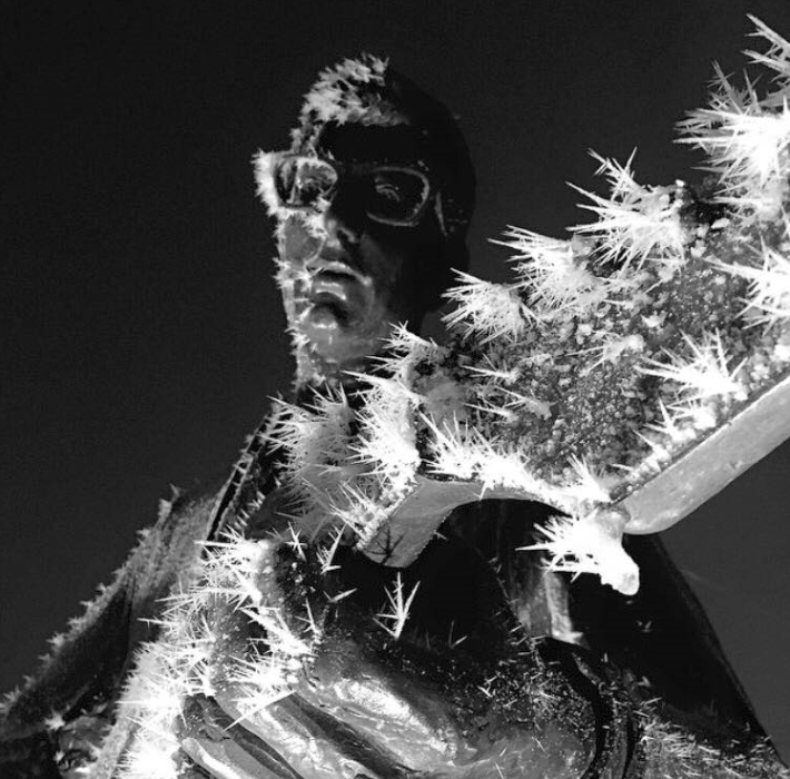 |
| The riming was not limited to trees, but formed on nearly any exposed surface. Here is an image of what the prolonged period of freezing fog did to the Buddy Holly statue located in downtown Lubbock. The image is courtesy of Visit Lubbock. |
| |
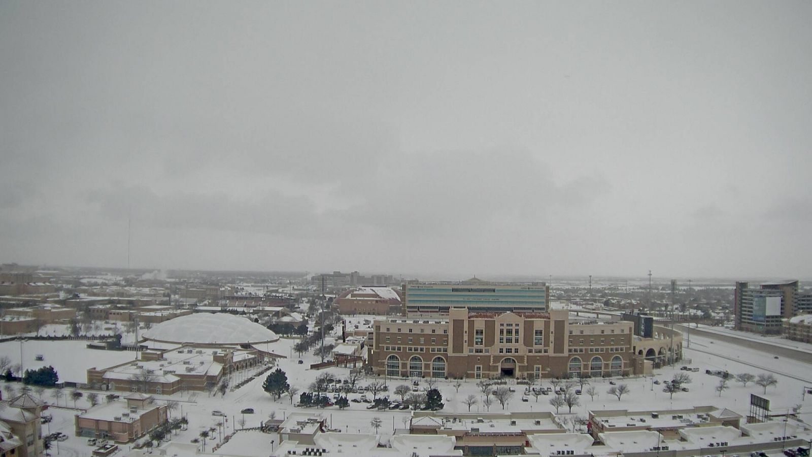
| The snow that blanketed the region in late February did also make for some pretty sites, like the one at Maxey Park and on the Texas Tech campus (see the images below). |
| |
 |
| Snow blanketing Maxey Park in Lubbock on February 28, 2015. |
| |
|
|
| Pictures of the snow around the Texas Tech campus on the 27th of February 2015. The left picture was captured around 10 am and is courtesy of KAMC. The right picture was taken around 5 am and is courtesy of Sam Nettleton. |
| |
| Unfortunately for those wishing to travel about, the snow (and freezing fog) did make getting around difficult. As the below images show, snow even covered the major roadways in the region, with the prolonged cold temperatures keeping road conditions from improving very quickly. |
|
|
| Two different views of Interstate-27 and Loop 289 in south Lubbock during the morning hours of February 27, 2015. The left image was taken at 6:46 am and the right image was captured at 9:59 am. The images are courtesy of TXDOT. |
| |
|
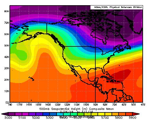
So what weather pattern produced such cold and wintry weather for West Texas (and much of the nation)? The below left image shows the mean weather pattern in the middle part of the atmosphere, with a ridge of deep, warm air (oranges) in the eastern Pacific, and cold air (purples) over the northeast part of North America. Where the gradient in temperatures/heights (colors) exits, the jet stream is located. In this pattern, air from northwest Canada and Alaska is directed southeastward into the United States.
|
| |
|
|
| A few different ways of viewing the average weather pattern from February 26th through March 1st. The left image shows the composite geopotential height in the mid-levels of the atmosphere (500 mb). The center image displays the composite temperatures anomaly over the four day stretch. The right image illustrates the composite anomalies of Outgoing Longwave Radiation (OLR) from late February through March 1st. All anomalies are calculated in reference to the 1981-2010 climatology |
| |
| The center and right images (above) show two different perspectives on what resulted from the weather pattern discussed in the previous paragraph. In the center image it is obvious that very cold air, averaging 10 or more degrees Kelvin (equivalent to 18+ degrees Fahrenheit) below normal, engulfed much of the center of the nation. This cold air set the stage for widespread wintry weather. The right image shows the Outgoing Longwave Radiation (OLR), which is a measure of how much energy the earth emits back to space. Where clouds (and precipitation) exist, they absorb the radiated energy and keep much of it from escaping to space. On the other hand, where skies are clear, most of the energy emitted from the earth escapes to space. Thus, the large negative anomalies in OLR over much of the nation suggest that there were widespread clouds and precipitation from late February through March 1st. The combination of the widespread clouds/precipitation and the anomalously cold temperatures resulted in the wintry mess that plagued much of the center and eastern part of the nation. |
| |


 Follow us on YouTube