|
Tornadoes, large hail and flooding rain |
|
 |
|
|
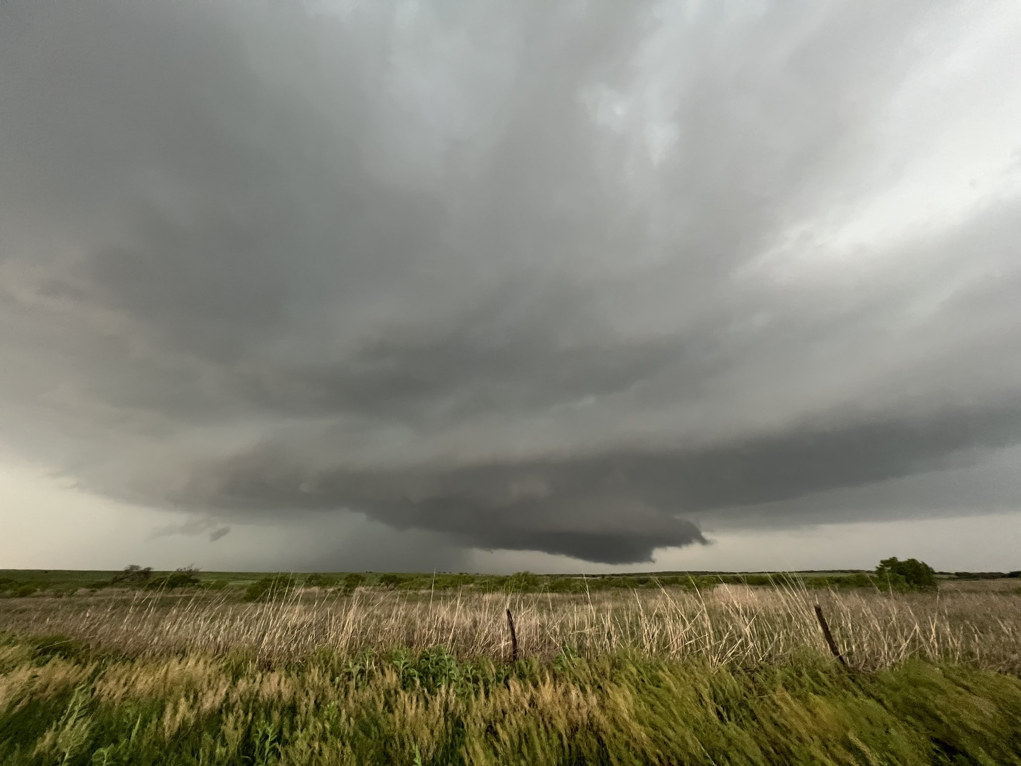
Supercell thunderstorm and wall cloud near Turkey on Wednesday, 1 May 2024. The picture is courtesy of Zane Hamilton. |
|
|
The first of May started off with a bang as thunderstorms erupted across a good chunk of West Texas. Abundant moisture and cold air aloft supplied very strong instability, and when coupled with stout southeasterly surface winds and modest westerly winds aloft, many of the thunderstorms quickly intensified to severe levels. |
|
 |
|
| RGB "True Color" satellite loop valid from 3:06 pm to 5:31 pm on Wednesday, 1 May 2024. An infrared satellite loop, valid from 6:31 pm to 8:56 pm, can be VIEWED HERE. | |
| The initial thunderstorm development favored the Davis Mountains and the central Texas Panhandle, but the activity gradually filled in over much of the South Plains and Rolling Plains through the evening hours. | |
 |
|
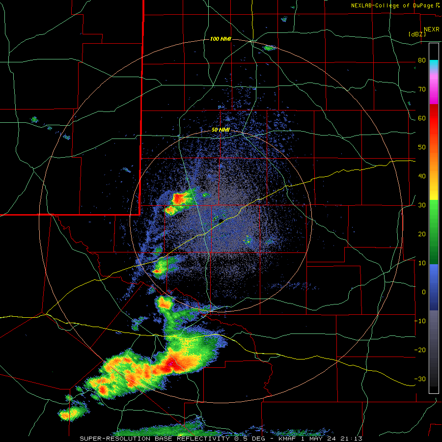
| Regional radar animation valid from 2:15 pm on Wednesday to 12:55 am on Thursday (1-2 May 2024). | |
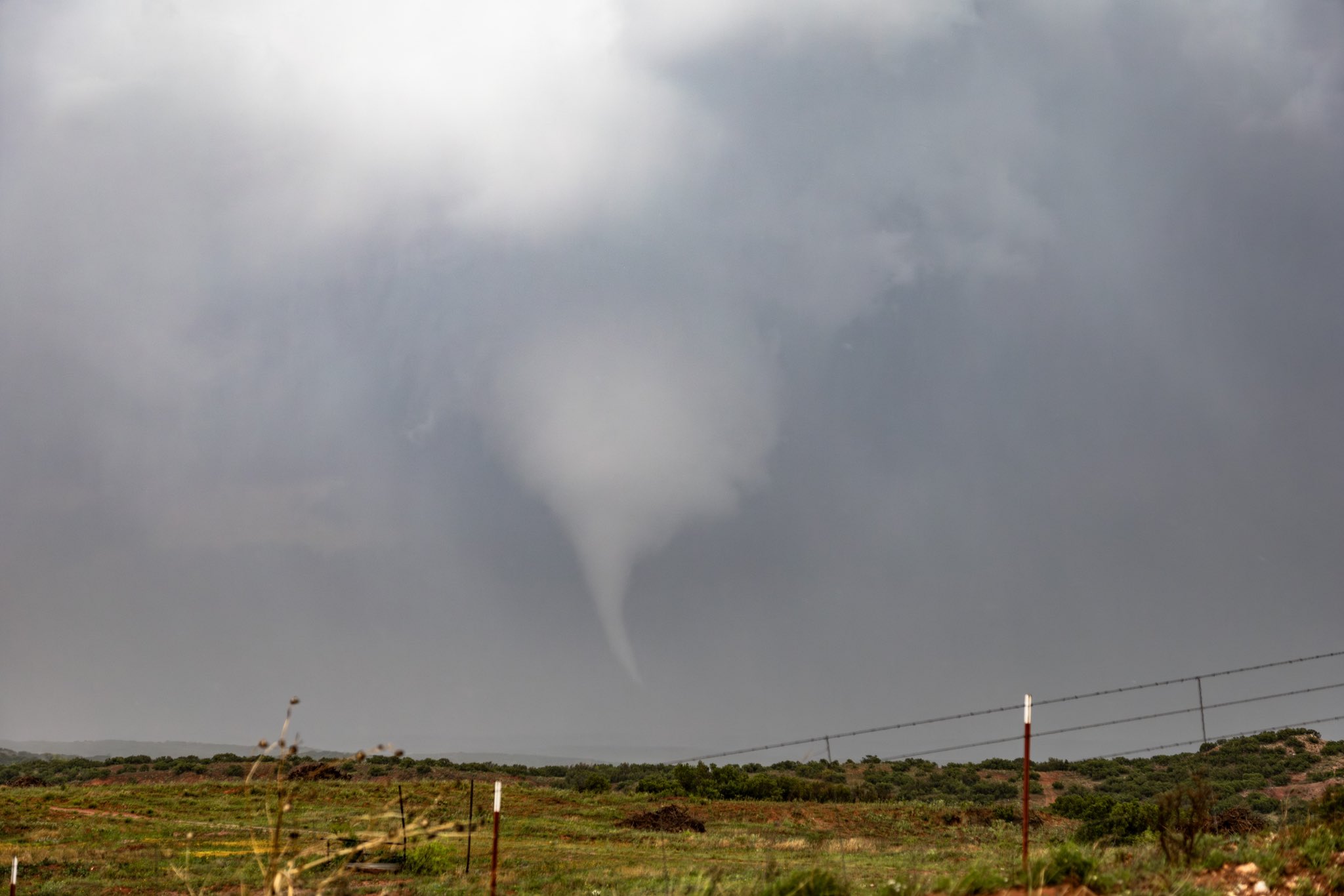
| Several of the thunderstorms began to rotate, becoming supercells. The right moving (cyclonically rotating) supercells slowed to a crawl, produced pockets of very large hail, several wall and funnel clouds and even a few tornadoes. The first storm to become tornadic in Lubbock's area of responsibility was near Turkey, Texas. Specifically, a tornado was reported about 7 miles north-northwest of Turkey at 5:49 pm. | |
 |
|
| Funnel cloud and possible tornado north of Turkey before 6 pm on 1 May 2024. The picture is courtesy of Blake Brown. Another view of this tornado around the same time, courtesy of Kyle Allen and Jacob Riley, can be VIEWED HERE. | |
| Thankfully, the tornado remained over open land and inflicted no known damage. | |
 |
|
| Amarillo WSR-88D radar animation valid from 3:54 pm to 8:03 pm on Wednesday (1 May 2024). An additional radar animation from Amarillo, valid from 6:50 pm to 9:25 pm on Wednesday (1 May 2024), can be VIEWED HERE. | |
| The tornadic storm also dropped very large hail, in excess of baseball size, as seen below. | |
 |
|
| Very large hail measured about 10 miles northwest of Turkey on 1 May 2024. The picture is courtesy of Shelden Breshears. | |
|
The same supercell evolved through the evening, but refused to move for several hours. Eventually, it produced at least one more tornado, again near Turkey, though this time northeast of town. Thankfully, again, the tornado remained over rural land and no damage was reported. |
|
 |
|
| Tornado northeast of Turkey around 8 pm on Wednesday, 1 May 2024. The image is courtesy of Blake Brown. | |
|
In addition to the tornadoes and hail, torrential rain fell for 3+ hours over western portions of Hall County and far eastern Briscoe County. A broad core of 3+ inches, perhaps as high as 9 inches, fell between Turkey and Lakeview Wednesday evening. |
|
 |
|
| 24-hr Multi-Radar Multi-Sensor (MRMS) precipitation, ending at 6 am on Thursday (2 May 2024). | |
|
The excessive rainfall produced widespread areal and flash flooding Wednesday evening and night. Street flooding, erosion and mud flows impacted Turkey, as well as many of the roadways north and northeast of Turkey. |
|
 |
 |
 |
 |
 |
 |
 |
 |
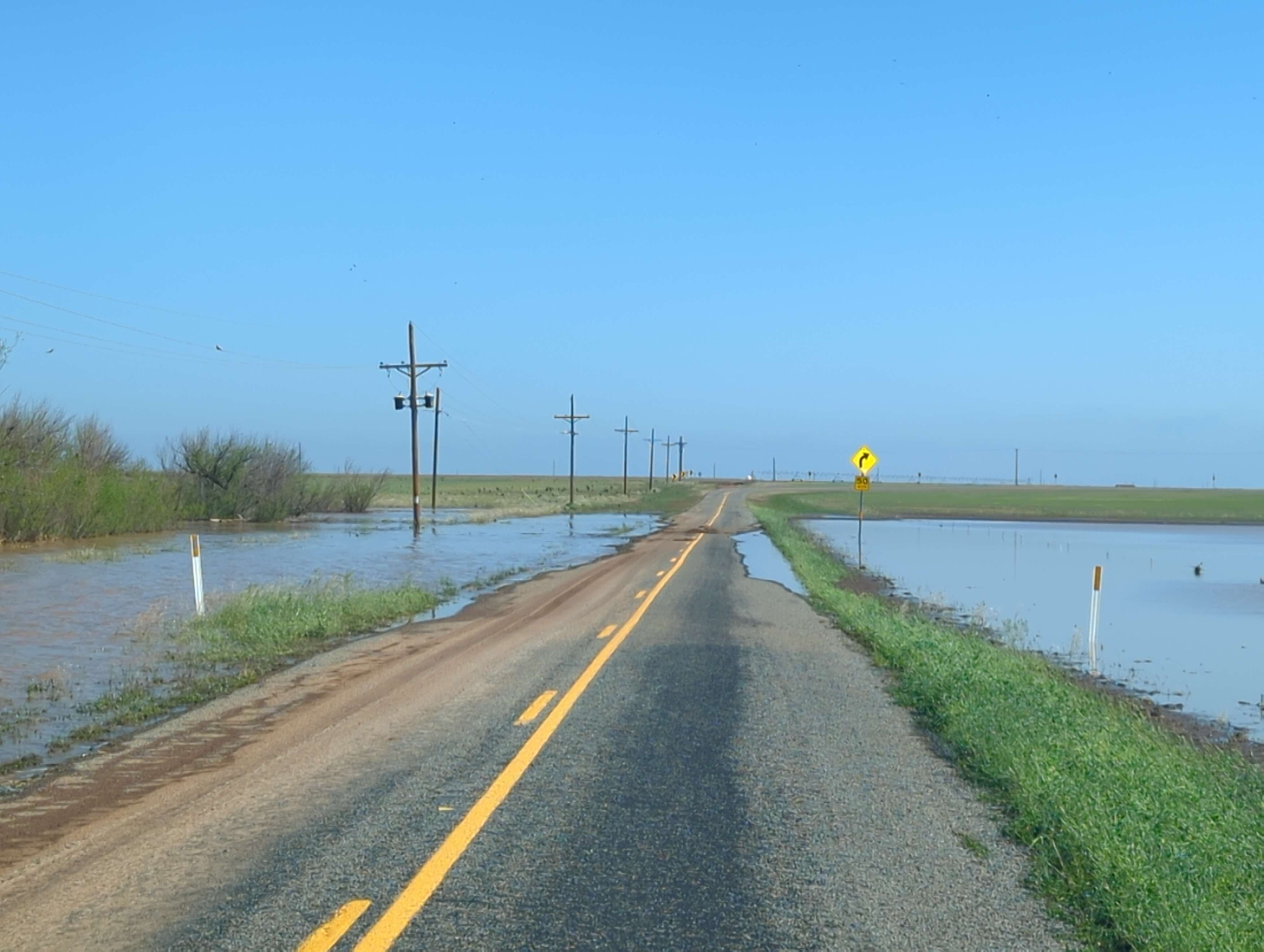
| Signs of extensive flooding on the Little Red River in and around FM 657 (about 12 miles northeast of Turkey), which is located approximately 2.5 miles south of the primary channel of the Prairie Dog Town Fork of the Red River. The pictures were taken the afternoon of 2 May 2024. | |
| The bulk of the rain fell in the Little Red River and Prairie Dog Town Fork of the Red River basins, and resulted in rapid rises and strong flows. The Little Red River breached its banks, flowing over FM 657 about 12 miles northeast of Turkey. The rapidly flowing water knocked down the vegetation, scoured the edges of the river bank and washed out a power pole. | |
 |
|
| (Left) View of the Prairie Dog Town Fork of the Red River, from Highway 70 north of Turkey, early Thursday afternoon (2 May 2024). (Right) Residual dirty/muddy roadways in/around Turkey Thursday afternoon. | |
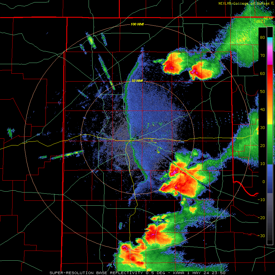
| Farther southwest, a left moving thunderstorm raced northward out of the Permian Basin and into the central South Plains. This storm brought strong to severe winds, small hail and brief torrential rain as it moved across Lubbock. A few wind gusts in excess of 60 mph were measured in and around Lubbock, with several reports of quarter size hail over the western portion of the city. | |
 |
|
| Midland WSR-88D radar animation valid from 4:13 pm to 8:00 pm on Wednesday (1 May 2024). | |
| Between the Lubbock left moving (anti-cyclonically rotating) storm and the semi-permanent cyclonically rotating storm near Turkey, another slow-moving supercell developed in northwest Crosby County. This storm went on to produce a brief tornado along with torrential rain before weakening and being shunted eastward by the fast-moving storms overtaking it from the southwest. | |
 |
 |
| (Left) Wall cloud near Ralls Wednesday evening, 1 May 2024. The picture is courtesy of sonone1025 via Twitter/X. (Right) Funnel cloud and possible tornado north of Lorenzo Wednesday evening. The image is courtesy of Linda Garcia and Jacob Riley. | |
| The intense storm winds knocked over a few center pivots north of Lorenzo and caused minor property damage to a farmstead about 8 miles north-northeast of Lorenzo. | |
 |
 |
| (Left) Flipped center pivot about 8 miles north of Lorenzo on Thursday, 2 May 2024. (Right) Small animal shed damaged and blown to the north of the farmstead, with is located about 8 miles north-northeast of Lorenzo. | |
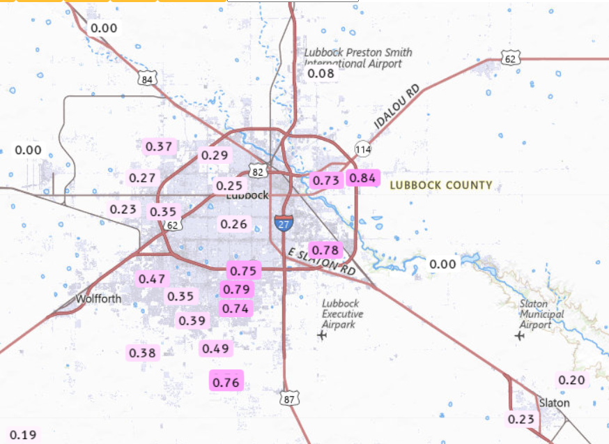
| Additionally, 2 to 3+ inches of rain fell over the course of a couple hours in northeast Crosby and southwest Floyd Counties. | |
 |
|
| 24-hr Multi-Radar Multi-Sensor (MRMS) precipitation, ending at 6 am on Thursday (2 May 2024). Rain totals over this same period, as measured by the West Texas Mesonet, can be FOUND HERE. A zoomed in view of the Lubbock area, with includes additional automated rain gauges, can be VIEWED HERE. | |
| The heavy rain flooded several fields and roads north and northeast of Lorenzo, leaving a muddy and wet mess in its wake the next day. | |
 |
 |
| Flooded roadways along FM 193 about 8-9 miles north-northeast of Lorenzo on Thursday morning, 2 May 2024. | |
| Storm reports collected from this active first day of May can be found below: | |
Preliminary Local Storm Report
National Weather Service Lubbock TX
504 AM CDT Thu May 2 2024

..TIME...   ...EVENT...      ...CITY LOCATION...     ...LAT.LON...
..DATE...   ....MAG....      ..COUNTY LOCATION..ST.. ...SOURCE....
            ..REMARKS..

0514 PM     Hail             10 NNW Turkey           34.53N 100.93W
05/01/2024  E1.75 Inch       Hall               TX   Park/Forest Srvc

            Re-issued to correct location of previous
            hail report from Turkey.

0549 PM     Tornado          7 NNW Turkey            34.49N 100.94W
05/01/2024                   Hall               TX   Emergency Mngr

            Brief tornado touch down 7 miles NNW of
            Turkey.

0553 PM     Hail             10 NE Caprock Canyons S 34.55N 100.96W
05/01/2024  M1.25 Inch       Briscoe            TX   Public

            Report from mPING: Half Dollar (1.25 in.).

0554 PM     Tstm Wnd Gst     2 S Brownfield          33.15N 102.27W
05/01/2024  M61 MPH          Terry              TX   Mesonet

0557 PM     Hail             10 NE Caprock Canyons S 34.55N 100.96W
05/01/2024  E3.25 Inch       Briscoe            TX   Public

            Corrects time and location of previous hail
            report from 1 NE Turkey. Social media photo
            shows partially melted hailstone measuring
            about 3.2 inches in diameter which was found
            several minutes after it fell. Time
            estimated from radar.

0616 PM     Hail             2 SSW Woodrow           33.41N 101.85W
05/01/2024  E1.25 Inch       Lubbock            TX   Fire Dept/Rescue

            Corrects time and location of previous hail
            report from Woodrow. Fire Dept reported
            mostly quarter size stones with a few
            slightly larger.

0617 PM     Hail             Woodrow                 33.45N 101.84W
05/01/2024  M1.00 Inch       Lubbock            TX   Fire Dept/Rescue

0631 PM     Tstm Wnd Gst     6 SSW Wolfforth         33.42N 102.05W
05/01/2024  M69 MPH          Lubbock            TX   Mesonet

            Corrects location of previous tstm wnd gst
            report from 5 NNE Tahoka. West Texas
            Mesonet. Additional gusts ranging from 58 to
            64 mph were also measured from 630 to 636
            PM.

0631 PM     Tstm Wnd Gst     5 NNE Tahoka            33.24N 101.77W
05/01/2024  M69 MPH          Lynn               TX   Mesonet

0635 PM     Tstm Wnd Dmg     1 NNE Lubbock           33.60N 101.84W
05/01/2024                   Lubbock            TX   Emergency Mngr

            Tree limbs several inches in diameter blown
            down in Mackenzie Park. Time estimated from
            radar.

0641 PM     Tstm Wnd Gst     Reese Center            33.61N 102.05W
05/01/2024  M61 MPH          Lubbock            TX   Mesonet

            West Texas Mesonet. Additional gusts ranging
            from 58 to 60 mph measured from 638 PM
            through 642 PM.

0643 PM     Tstm Wnd Gst     6 S Lubbock             33.50N 101.88W
05/01/2024  M58 MPH          Lubbock            TX   Mesonet

            West Texas Mesonet.

0643 PM     Hail             2 NW Woodrow            33.47N 101.86W
05/01/2024  E1.50 Inch       Lubbock            TX   Public

            Report from mPING: Ping Pong Ball (1.50
            in.).

0643 PM     Tstm Wnd Gst     6 W Lubbock             33.57N 101.94W
05/01/2024  M61 MPH          Lubbock            TX   Mesonet

            West Texas Mesonet. Additional gust to 61
            mph measured at 644 PM.

0644 PM     Hail             2 E Wolfforth           33.51N 101.97W
05/01/2024  E1.00 Inch       Lubbock            TX   Public

            Report from mPING: Quarter (1.00 in.).

0646 PM     Hail             4 SE Reese Center       33.56N 101.97W
05/01/2024  E1.00 Inch       Lubbock            TX   Public

            Report from mPING: Quarter (1.00 in.).

0649 PM     Hail             3 E Reese Center        33.59N 101.97W
05/01/2024  E1.00 Inch       Lubbock            TX   Public

            Report from mPING: Quarter (1.00 in.).

0656 PM     Tstm Wnd Gst     4 NNE Shallowater       33.74N 101.97W
05/01/2024  M59 MPH          Lubbock            TX   Mesonet

            West Texas Mesonet. Also gusted to 58 mph at
            655 PM.

0658 PM     Hail             5 NW Lubbock            33.63N 101.90W
05/01/2024  E1.00 Inch       Lubbock            TX   Public

            Minor hail dents on automobile exterior.

0705 PM     Tstm Wnd Gst     4 E Lubbock             33.58N 101.78W
05/01/2024  M73 MPH          Lubbock            TX   Mesonet

0707 PM     Tstm Wnd Gst     6 E New Deal            33.73N 101.74W
05/01/2024  M59 MPH          Lubbock            TX   Mesonet

            West Texas Mesonet.

0710 PM     Tstm Wnd Gst     1 NNW Lubbock Int. Airp 33.67N 101.82W
05/01/2024  M60 MPH          Lubbock            TX   ASOS

            Lubbock Int. Airport ASOS. Additional gusts
            ranging from 58 to 59 mph measured from 654
            PM through 709 PM.

0710 PM     Tornado          6 N Lorenzo             33.75N 101.53W
05/01/2024                   Crosby             TX   Broadcast Media

            Media relayed video of brief touchdown of a
            weak rope tornado between Lorenzo and
            Petersburg.

0720 PM     Landspout        2 E Petersburg          33.87N 101.57W
05/01/2024                   Hale               TX   Broadcast Media

            Media relayed video of a landspout occurring
            near Petersburg. Location estimated.

0729 PM     Tstm Wnd Gst     5 SSW Graham            33.08N 101.50W
05/01/2024  E61 MPH          Garza              TX   Mesonet

0744 PM     Hail             1 N Plainview           34.21N 101.72W
05/01/2024  E1.50 Inch       Hale               TX   Public

            Report from mPING: Ping Pong Ball (1.50
            in.). Time estimated from radar.

0751 PM     Tstm Wnd Gst     2 NNE Floydada          34.01N 101.32W
05/01/2024  M62 MPH          Floyd              TX   Mesonet

0752 PM     Tornado          5 NE Turkey             34.43N 100.82W
05/01/2024                   Hall               TX   Public

            Re-issued to correct time and location of
            previous tornado report from 1 NE Turkey.
            Multiple social media photos and videos of a
            tornado several miles northeast of Turkey
            near County Road 8 and Texas Highway 86
            between 752 PM and 757 PM.

0801 PM     Tornado          4 NE Turkey             34.44N 100.85W
05/01/2024                   Hall               TX   911 Call Center

0802 PM     Tstm Wnd Gst     3 NNW Mcadoo            33.77N 101.03W
05/01/2024  M69 MPH          Dickens            TX   Mesonet

0805 PM     Tstm Wnd Gst     2 WSW Turkey            34.38N 100.93W
05/01/2024  M59 MPH          Hall               TX   Mesonet

0814 PM     Flash Flood      6 N Cone                33.88N 101.37W
05/01/2024                   Floyd              TX   911 Call Center

0822 PM     Tstm Wnd Gst     2 WSW Turkey            34.38N 100.93W
05/01/2024  M62 MPH          Hall               TX   Mesonet

            West Texas Mesonet.

0828 PM     Tstm Wnd Gst     3 N Roaring Springs     33.94N 100.86W
05/01/2024  M58 MPH          Motley             TX   Mesonet

0834 PM     Tstm Wnd Gst     7 WSW Lakeview          34.65N 100.81W
05/01/2024  M59 MPH          Hall               TX   Mesonet

0835 PM     Non-Tstm Wnd Gst 3 ENE South Plains      34.24N 101.26W
05/01/2024  M64 MPH          Floyd              TX   Mesonet

            West Texas Mesonet. Additional gust to 59
            mph at 836 PM. Occurred after thunderstorms
            had exited to the northeast.

0848 PM     Landslide        10 NNW Turkey           34.53N 100.93W
05/01/2024                   Hall               TX   Public

0848 PM     Landslide        8 NNW Turkey            34.51N 100.93W
05/01/2024                   Hall               TX   Public

            Corrected location. Public reported viewing
            several landslides within the canyons while
            driving on Texas Highway 70 north of Turkey.

0854 PM     Tstm Wnd Gst     1 SSE Jayton            33.24N 100.57W
05/01/2024  M80 MPH          Kent               TX   Mesonet

0924 PM     Flash Flood      Turkey                  34.39N 100.89W
05/01/2024                   Hall               TX   Public

            Social media video shows several inches of
            water flowing over roadways in downtown
            Turkey.

0957 PM     Flash Flood      5 NE Turkey             34.45N 100.84W
05/01/2024                   Hall               TX   Public

            Social media video shows several inches of
            water flowing over roadways northeast of
            Turkey.

1000 PM     Flash Flood      8 SSW Lakeview          34.56N 100.75W
05/01/2024                   Hall               TX   Law Enforcement

            Hall County Sheriff relayed video of several
            inches of water flowing over FM-657 near the
            Prairie Dog Town Fork Red River. Also
            reported the river was overflowing out of
            its banks.

1011 PM     Non-Tstm Wnd Gst 1 NE Memphis            34.73N 100.53W
05/01/2024  M59 MPH          Hall               TX   Mesonet

