|
Hot and dusty high-based thunderstorms 14 - 15 May 2026 |
|
 |
|
|
"RGB-True Color" satellite loop valid from 12:16 pm to 5:56 pm on Thursday (14 May 2026). |
|
|
Mid-May 2026 brought the heat, along with a couple of rounds of high-based thunderstorms. Temperatures soared into the 90s, with triple digit highs common off the Caprock through the middle of the month. The heat was supplemented by a surge in mid-level moisture, courtesy of the eastern Pacific Ocean, on May 14th and 15th. |
|
 |
|
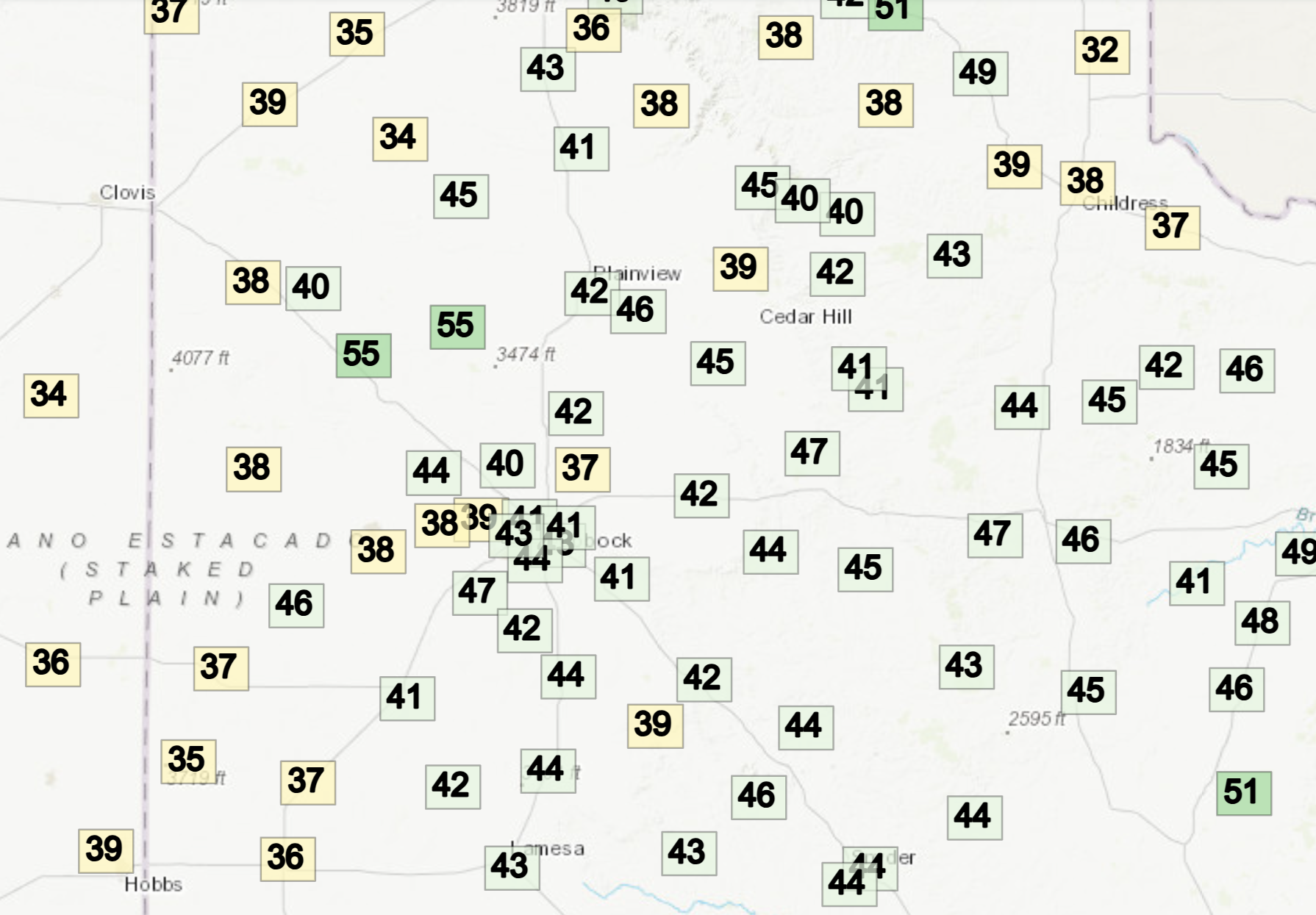
| High temperatures measured by the Texas Tech West Texas Mesonet (WTM) on Thursday (14 May 2026). The dewpoint and relative humidity observed at 6:15 pm on Thursday can be viewed HERE and HERE, respectively. | |
| The heat and mid-level moisture fueled the development of scattered high-based thunderstorms Thursday afternoon (14 May) and again Friday afternoon (15 May). Unfortunately, both days saw a dearth in low-level moisture, which lead to the high-based nature of the thunderstorm activity. | |
 |
|
| Lubbock WSR-88D radar animation valid from 2:30 pm to 9:04 pm on Thursday (14 May 2026). | |
| The deep, hot and dry sub-cloud layer limited rainfall coverage and intensity, as much of the rain falling from the storms evaporated before reaching the ground. In addition, the large amounts of evaporation aloft caused significant cooling of the air. The cooler, heavier air, accelerated downward and resulted in strong to severe wind gusts upon impacting the ground. The intense winds kicked up copious amounts of dust, creating brief brownouts in spots as the thunderstorm outflows moved through. | |
 |
|
| Dusty scene near Friona on Thursday afternoon (14 May 2026). The picture is courtesy of Mr Optimism (@bwhite70) on X. | |
| Over the course of the hot stretch, Childress recorded a peak temperature of 105 degrees on May 15th, tying the daily record high originally set in 1996. At Lubbock, temperatures peaked shy of record levels, but did get as high as 99 degrees on May 16th, while touching 98 degrees on May 14th, 15th and 17th. This heat was not atypical for 2026, as both Lubbock and Childress had the warmest average temperatures on record to this point in the year (January 1st through May 15th). | |
 |
|
| High temperatures measured by the Texas Tech West Texas Mesonet (WTM) on Friday (15 May 2026). The dewpoint and relative humidity observed at 7:05 pm on Friday can be viewed HERE and HERE, respectively. | |
| Despite many locations hearing thunder and seeing wind and dust, measurable rainfall over this stretch was more difficult to come by. A lot of locations were "lucky" to see a few raindrops Thursday and/or Friday. | |
 |
|
| Regional radar animation valid from 3:20 pm on Friday to 1:10 am on Saturday (15-16 May 2026). A close up loop from the Lubbock WSR-88D, valid from 2:54 pm on Friday to 7:21 am on Saturday, can be FOUND HERE. | |
| What was lacking in rain, was more than made up for in wind and dust. Walls of dust (known as a haboob) swept through many locations, often accompanied by wind gusts of 50+ mph. | |
 |
|
| Leading edge of the wind and dust moving across Lubbock Friday evening (15 May 2026). | |
| Unfortunately, the ongoing drought and relative lack of green up meant that the residual dry vegetation was susceptible to fire starts. Lightning from the moisture-starved storms served as the ignition source in a number of spots, starting wildfires through the region, from West Texas into southwestern Kansas. The below shortwave infrared satellite animation shows various fires (black "hot spots") dotted across the countryside Friday afternoon and evening. | |
 |
|
| Shortwave infrared satellite loop, valid from 1:36 pm to 6:56 pm, on Friday (15 May 2026). An "RGB-True Color" satellite animation, valid from 12:36 pm to 7:01 pm on Friday, can be VIEWED HERE. | |
|
In addition to the dust and fire starts, several locations across the South Plains, Rolling Plains and southern Texas Panhandle recorded severe-caliber wind gusts on Thursday and Friday, as illustrated below. A peak gust of 71 mph was recorded by the WTM site near Dimmitt on Thursday evening, shortly after a wooden light pole was snapped at the softball/baseball fields in Friona. The following day, a peak wind gust of 72 mph was recorded by the O'Donnell WTM Friday evening. |
|
 |
|
| Severe storm reports plotted for Thursday (14 May 2026) on the left and Friday (15 May 2026) on the right. The images are courtesy of the Storm Prediction Center (SPC). | |
| Rainfall totals were not impressive over this mid-May stretch, with most locations recording anywhere from a trace to a tenth of an inch. A few did manage to eke out a bit more, with a tenth to half inch of rain dotting parts of the southeast South Plains into the Rolling Plains and southeast Texas Panhandle. The highest measured rain total was recorded at Spur, a whopping 0.55 inches. | |
 |
|
| 2-day radar-estimated and biased-corrected precipitation ending at 7 am on Saturday (16 May 2026). Measured rainfall over this same period, courtesy of the WTM, can be VIEWED HERE. Rainfall reports over this same stretch from around Lubbock County can be FOUND HERE. | |
|
Officially, the Lubbock Airport only measured a trace of rain, both over this stretch and for the month to this point. This ties several other years for the driest start to May in Lubbock. A list of the preliminary storm reports collected over this hot, dry, dusty and windy mid-May stretch can be found below. |
|
Preliminary Local Storm Report...Summary
National Weather Service Lubbock TX
857 PM CDT Thu May 14 2026

..TIME...   ...EVENT...      ...CITY LOCATION...     ...LAT.LON...
..DATE...   ....MAG....      ..COUNTY LOCATION..ST.. ...SOURCE....
            ..REMARKS..

0423 PM     Tstm Wnd Gst     3 S Levelland           33.53N 102.36W
05/14/2026  M60 MPH          Hockley            TX   Mesonet

            Corrected source. West Texas Mesonet.

0437 PM     Tstm Wnd Gst     2 NE Friona             34.66N 102.69W
05/14/2026  M63 MPH          Parmer             TX   Public

            West Texas Mesonet. Near-zero visibility
            from blowing dust.

0442 PM     Tstm Wnd Dmg     Friona                  34.63N 102.72W
05/14/2026                   Parmer             TX   Broadcast Media

            Broadcast media relayed a photo in Slack of
            a wooden light pole that snapped at the
            baseball and softball fields on the south
            side of Friona. Time estimated from radar
            and previous severe wind reports from the
            West Texas Mesonet.

0442 PM     Tstm Wnd Gst     2 NE Friona             34.66N 102.69W
05/14/2026  M61 MPH          Parmer             TX   Mesonet

            West Texas Mesonet.

0508 PM     Tstm Wnd Gst     2 NE Dimmitt            34.57N 102.29W
05/14/2026  M71 MPH          Castro             TX   Mesonet

            West Texas Mesonet. Zero-mile visibility
            from blowing dust in Dimmitt.

0511 PM     Tstm Wnd Gst     4 NNE Shallowater       33.75N 101.97W
05/14/2026  M58 MPH          Lubbock            TX   Mesonet

            West Texas Mesonet. Substantial dust foot
            evident on nearby webcams.

0511 PM     Tstm Wnd Gst     2 NE Dimmitt            34.57N 102.29W
05/14/2026  M66 MPH          Castro             TX   Mesonet

            West Texas Mesonet.

0542 PM     Tstm Wnd Gst     3 N Hart                34.43N 102.11W
05/14/2026  M63 MPH          Castro             TX   Mesonet

            West Texas Mesonet.

0545 PM     Tstm Wnd Dmg     4 ENE Woodrow           33.48N 101.78W
05/14/2026                   Lubbock            TX   Broadcast Media

            5 power poles and an outbuilding blown down.

0617 PM     Tstm Wnd Gst     1 ENE Flomot            34.23N 100.96W
05/14/2026  M61 MPH          Motley             TX   Mesonet

            West Texas Mesonet.

0657 PM     Tstm Wnd Gst     2 NNE Floydada          34.01N 101.33W
05/14/2026  M58 MPH          Floyd              TX   Mesonet

            West Texas Mesonet.

0716 PM     Tstm Wnd Gst     4 WSW Matador           34.00N 100.89W
05/14/2026  M59 MPH          Motley             TX   Mesonet

            West Texas Mesonet.

0717 PM     Tstm Wnd Gst     2 NNE Childress         34.46N 100.20W
05/14/2026  M62 MPH          Childress          TX   Mesonet

            West Texas Mesonet.

0750 PM     Wildfire         1 WSW Matador           34.01N 100.84W
05/14/2026                   Motley             TX   Park/Forest Srvc

            1500 acre wildfire started by lightning on
            the 14th.



 Follow us on X
 Follow us on Facebook
 Follow us on YouTube
 LUB RSS Feed