|
A stormy Saturday afternoon and evening |
|
 |
|
|
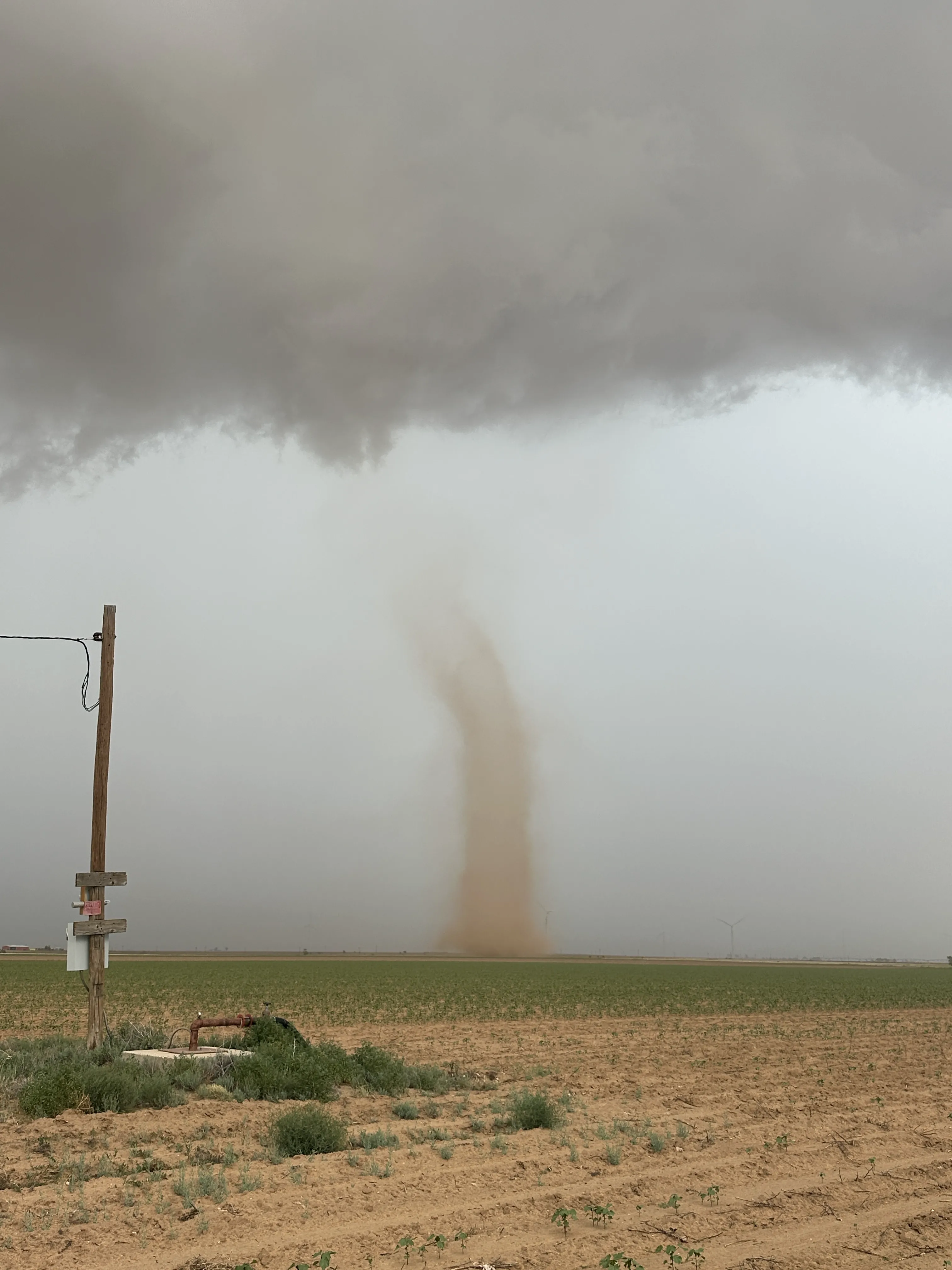
Landspout tornado captured northeast of Lorenzo around 5 pm on Saturday (18 July 2026). The picture is courtesy of Bruce Haynie. |
|
|
Hot and humid conditions, at least by West Texas' standards, fueled an active afternoon and evening of thunderstorm activity on Saturday, July 18th. Initially, showers and isolated thunderstorms formed over the southern Texas Panhandle early in the afternoon. As temperatures peaked in the upper 80s to middle 90s, numerous thunderstorms blossomed over the South Plains and Rolling Plains mid-late afternoon. |
|
 |
|
| Visible satellite loop valid from 2:31 pm to 7:06 pm on Saturday (18 July 2026). An infrared satellite loop, valid from 12:01 pm to 11:01 pm on Saturday, can be FOUND HERE. | |
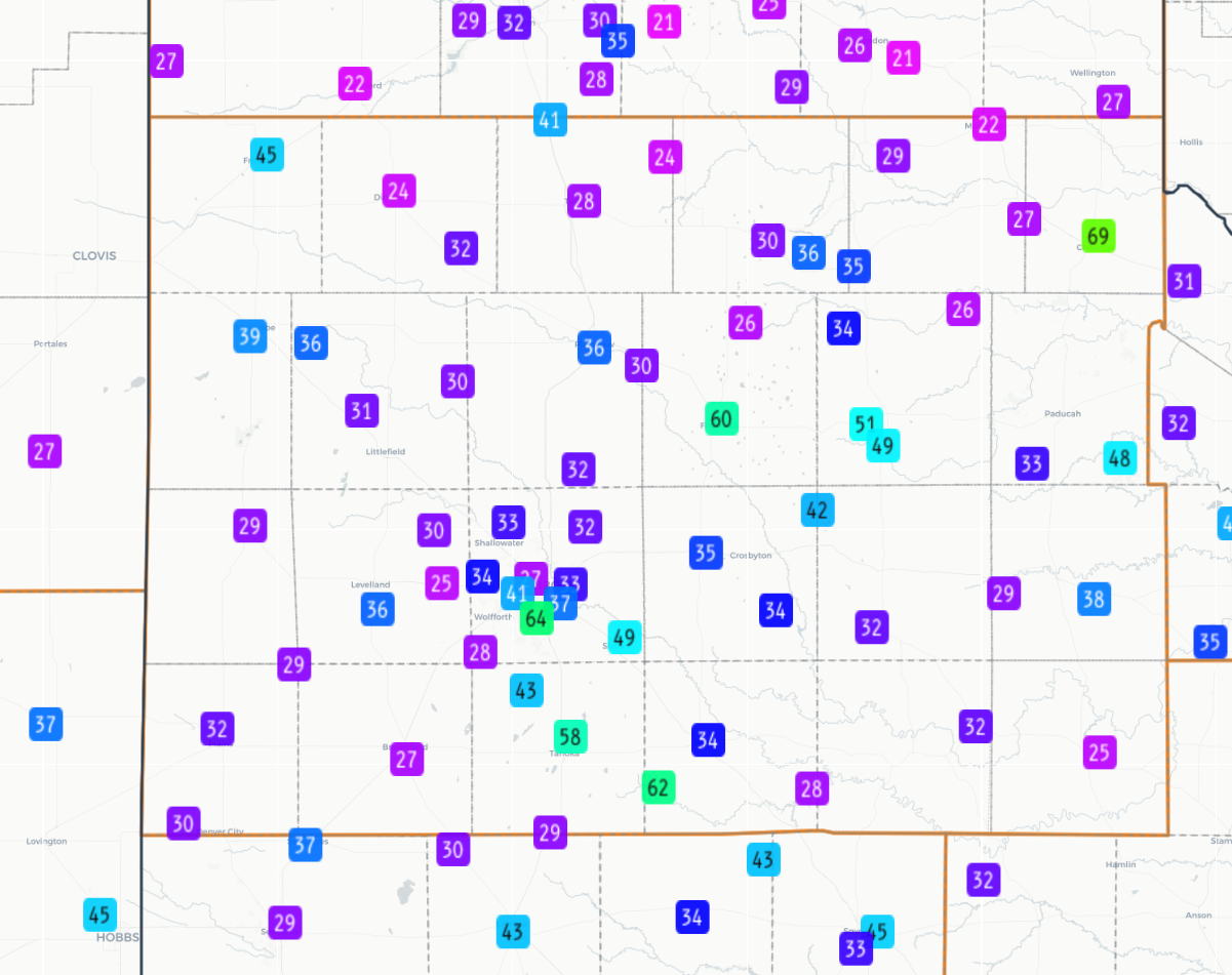
| Individual storms were not particularly well organized, largely due to the fact that the wind field throughout the depth of the atmosphere was weak. However, deep, rich moisture contributed to moderate instability that promoted brief strong thunderstorms that produced pockets of torrential rainfall and strong to severe-caliber wind gusts. The water-logged downdrafts generated wind gusts in excess of 45 mph at many locations, with several locations experiencing gusts of 60+ mph. The West Texas Mesonet (WTM) a couple of miles north of Childress reported a peak wind gust of 69 mph, which occurred in tandem with a thunderstorm that dropped a quick 2.16 inches of rainfall. | |
 |
|
| Peak wind gusts measured by the West Texas Mesonet (WTM) on Saturday (18 June 2026). | |
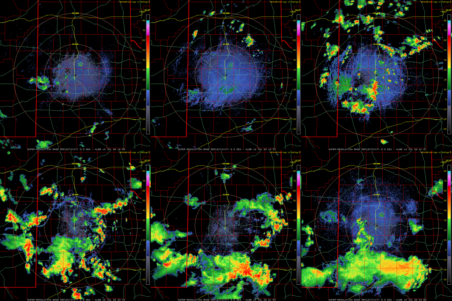
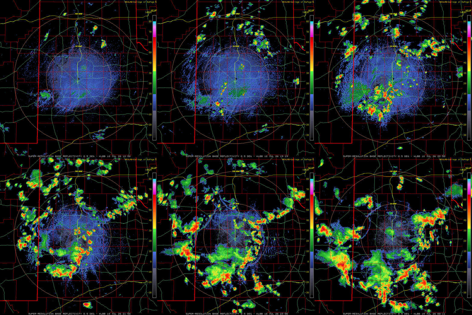
| Although the individual storms didn't move very fast or last too long, they did generate a plethora of outflow boundaries that went on to generate additional showers and thunderstorms as they raced away from their parent storm. Locations lucky enough to get directly below a thunderstorm experience a brief period of very heavy rain, often picking up a quick half inch to inch in 10s of minutes. A few spots, including near Childress, Matador and Tahoka, the torrential rain lasted a bit longer and allowed them to tally amount near or above 2 inches. | |
 |
|
| Lubbock WSR-88D animation valid from 1:08 pm to 7:11 pm on Saturday (18 July 2026). An additional radar animations, valid from 11:05 am to 11:06 pm on Saturday, can be VIEWED HERE. | |
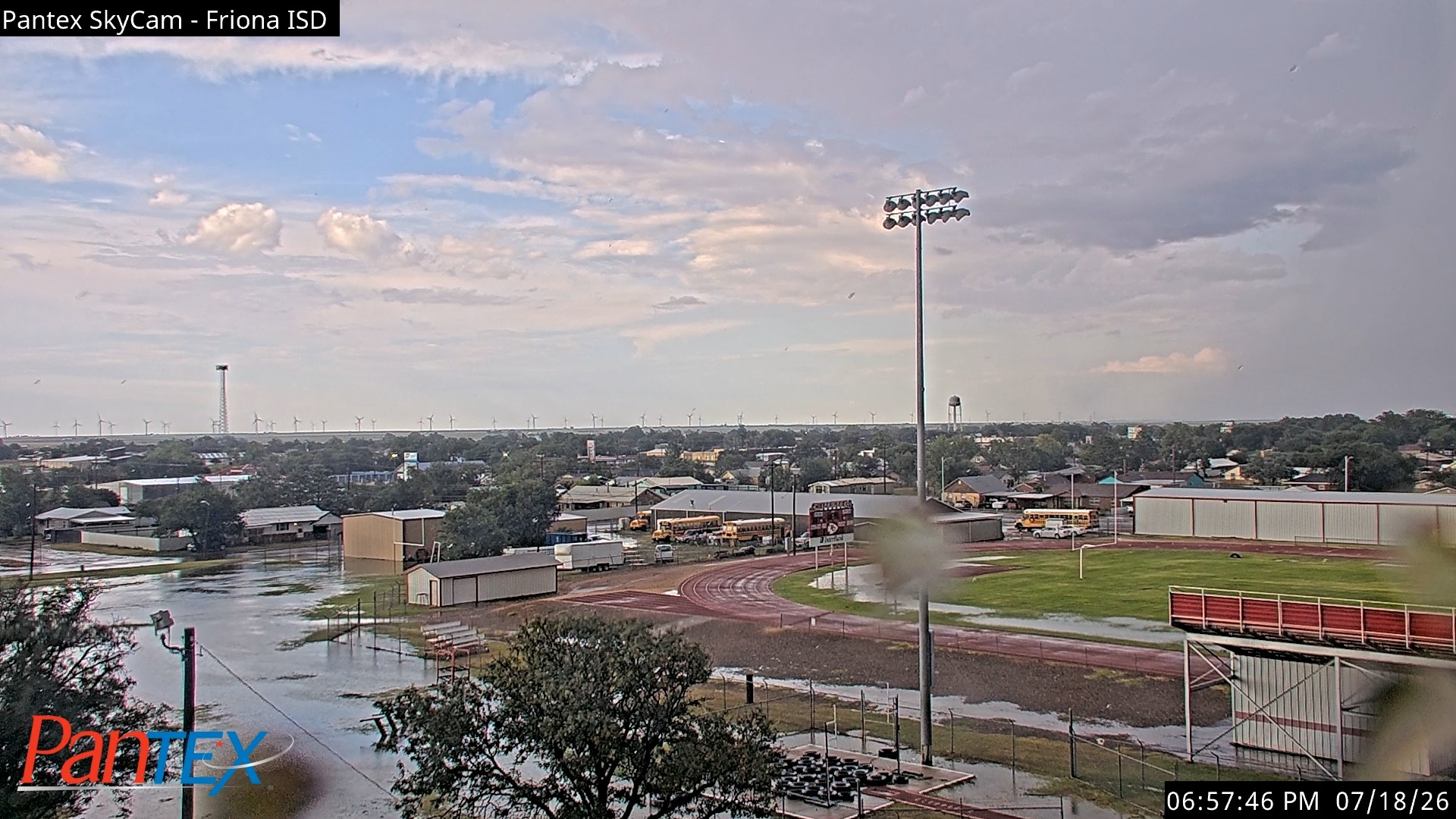
| Where the heaviest rain fell, runoff resulted in widespread street flooding and inundation of low-lying and poor drainage areas. Reports of street flooding were received from Matador, Paducah and north of Tahoka. Even Friona, which recorded over an inch of rain in about 20 minutes (on top of about 1 inch of rain that fell early in the day) experienced extensive street flooding Saturday evening. | |
 |
|
| Street flooding observed in Friona on Saturday evening (18 July 2026). The image is courtesy of Pantex. | |
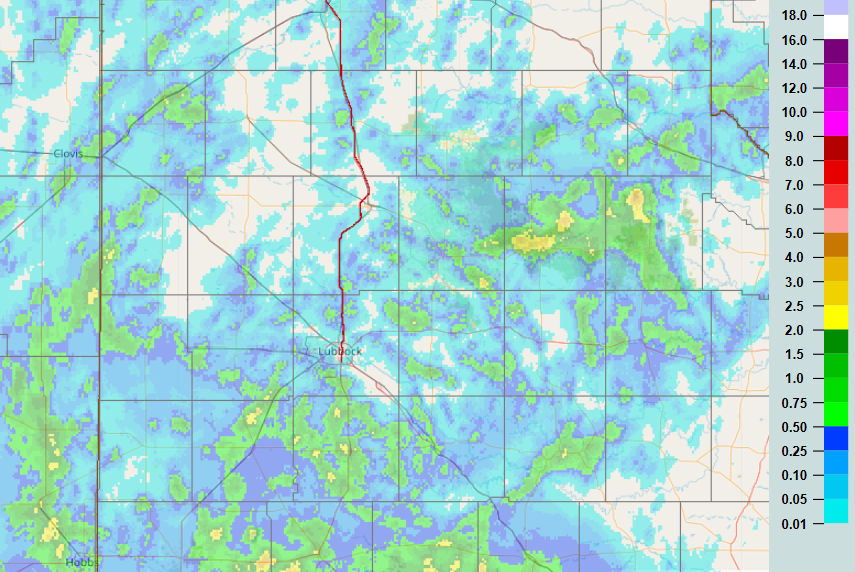
| Unfortunately, not everyone received beneficial rainfall, as the above image illustrates. Officially, the Lubbock Airport only recorded a trace of rainfall on July 18th, though the south and west edge of the city saw considerably more, in excess of 1/2 inch in spots. | |
 |
|
| 24-hour radar-estimated and bias-corrected rainfall (inches) ending at 8 am on Sunday (19 July 2026). | |
|
A list of the preliminary storm reports collected on July 18th can be found below. |
|
Preliminary Local Storm Report...Summary
National Weather Service Lubbock TX
1104 PM CDT Sat Jul 18 2026

..TIME...   ...EVENT...      ...CITY LOCATION...     ...LAT.LON...
..DATE...   ....MAG....      ..COUNTY LOCATION..ST.. ...SOURCE....
            ..REMARKS..

0352 PM     Tstm Wnd Gst     6 S Lubbock             33.50N 101.88W
07/18/2026  M65 MPH          Lubbock            TX   Mesonet

            Measured by the West Texas Mesonet. A wet
            microbust also produced a 64 mph gust at
            3:53 PM.

0426 PM     Tstm Wnd Gst     3 NNE Tahoka            33.21N 101.78W
07/18/2026  M58 MPH          Lynn               TX   Mesonet

            Measured by the West Texas Mesonet.

0503 PM     Landspout        3 NNE Lorenzo           33.71N 101.51W
07/18/2026                   Crosby             TX   NWS Employee

            Picture of a landspout just northeast of
            Lorenzo. It lasted 3-4 minutes before
            dissipating. Location estimated.

0505 PM     Flash Flood      2 N Tahoka              33.20N 101.80W
07/18/2026                   Lynn               TX   Law Enforcement

            Corrects previous flash flood report from 2
            N Tahoka. Highway 87 did have water on the
            roadway about 2 miles north of Tahoka, but
            the highway was not closed.

0516 PM     Tstm Wnd Gst     2 NNE Childress         34.46N 100.20W
07/18/2026  M70 MPH          Childress          TX   Mesonet

            Measured by the West Texas Mesonet. It was
            associated with a wet microburst that
            produced 0.11 inches of rain in 1 minute.

0539 PM     Tstm Wnd Gst     5 SSW Graham            33.08N 101.52W
07/18/2026  M62 MPH          Garza              TX   Mesonet

            Measured by the West Texas Mesonet.
            Additional severe-caliber gusts occurred at
            5:40 PM and 5:43 PM.

0543 PM     Tstm Wnd Gst     1 NNE Floydada          34.00N 101.33W
07/18/2026  M61 MPH          Floyd              TX   Mesonet

            Measured by the West Texas Mesonet.

0549 PM     Rain             2 NNE Childress         34.46N 100.20W
07/18/2026  M2.15 Inch       Childress          TX   Mesonet

            Measured by the West Texas Mesonet. The bulk
            of the rain fell between 4:30 and 5:30 pm.

0626 PM     Flash Flood      Friona                  34.64N 102.73W
07/18/2026                   Parmer             TX   Public

            Video feed of torrential rain and extensive
            street flooding and inundation of low spots
            in and around Friona ISD. A nearby rain
            gauge measured 1.15 inches of rain, most of
            which fell in 20 minutes.

0652 PM     Flood            1 S Matador             34.01N 100.82W
07/18/2026                   Motley             TX   Public

            Report from mPING: River/Creek overflowing;
            Cropland/Yard/Basement Flooding.

0758 PM     Rain             1 NE Matador            34.03N 100.81W
07/18/2026  M2.20 Inch       Motley             TX   CO-OP Observer

            Torrential rain observed by COOP observer in
            Matador. Most of the rain fell in an hour.

0814 PM     Flash Flood      Paducah                 34.01N 100.30W
07/18/2026                   Cottle             TX   Public

            Report from mPING: Street/road flooding;
            Street/road closed; Vehicles stranded.



 Follow us on X
 Follow us on Facebook
 Follow us on YouTube
 LUB RSS Feed