|
Late June and early July brings rounds of thunderstorms |
|||
 |
|||
|
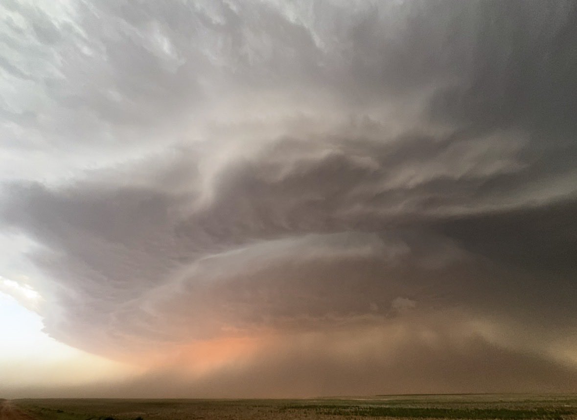
Supercell thunderstorm tracking over open land in Terry County on Tuesday evening (23 June 2026). The picture is courtesy of Joe Ponce. |
|||
|
Tuesday, June 23rd, kicked off a stretch of active weather for the West Texas region that persisted through much of the rest of the month and into early July. Intense heating, sufficient moisture, a southwestward moving outflow enhanced front and decent wind shear (by summer standards) combined to produce several severe thunderstorms that tracked southeastward across the area on Tuesday. |
|||
 |
|||
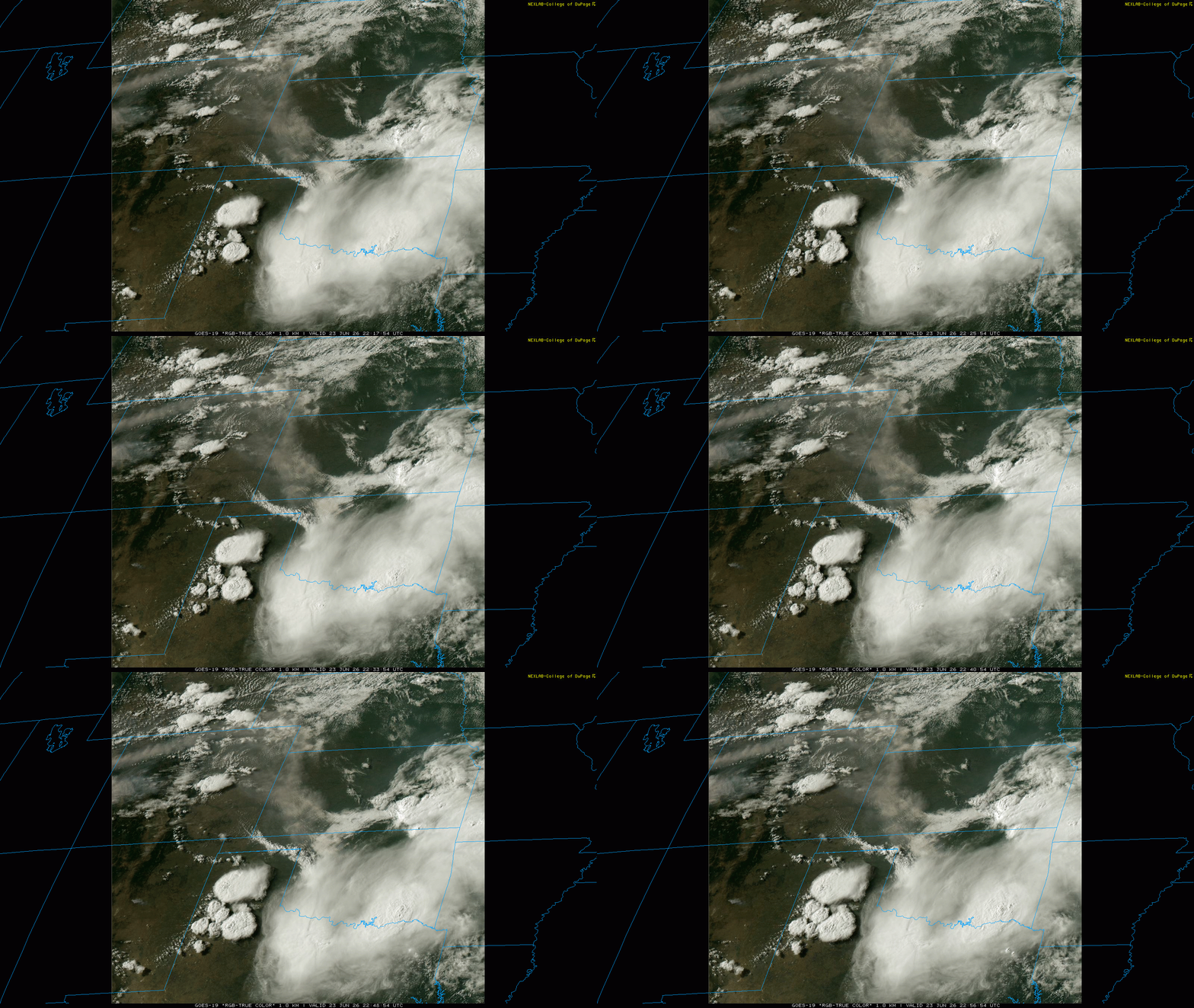
| "RGB-True Color" satellite loop valid from 6:17 pm to 6:56 pm on Tuesday (23 June 2026). | |||
| The initial storms formed along and immediately behind the advancing front/boundary mid-afternoon, with additional thunderstorms developing in the triple digit heat across the western South Plains during the late afternoon. There was sufficient wind shear to cause several of the high-based storms to organize and begin to rotate. These supercell thunderstorms went on to generate large hail, damaging winds and heavy rain as they advanced southeastward. | |||
 |
 |
||
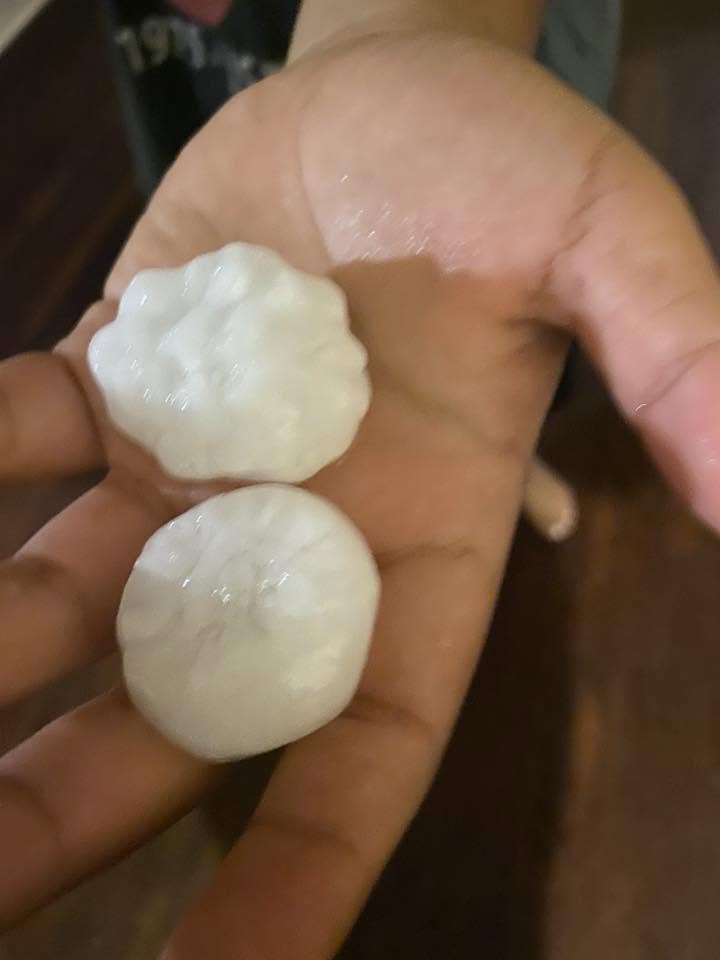
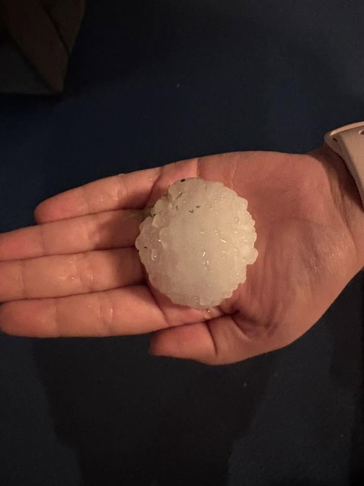
| Large hail that fell in Abernathy (left) and Levelland (right) on Tuesday evening (23 June 2026). The images are courtesy of Roxanna Rodriguez and Veronica Salinas, respectively. | |||
| Hail as large as golf balls were reported near Childress with the earliest activity shortly after midday. However, the more widespread "show" occurred later in the day, where golf ball size hail fell near Abernathy, Meadow and Levelland during the evening hours. Hail as large as baseballs was reported on the southwest side of Levelland, at the Country Club, shortly after 8 pm. | |||
 |
|||
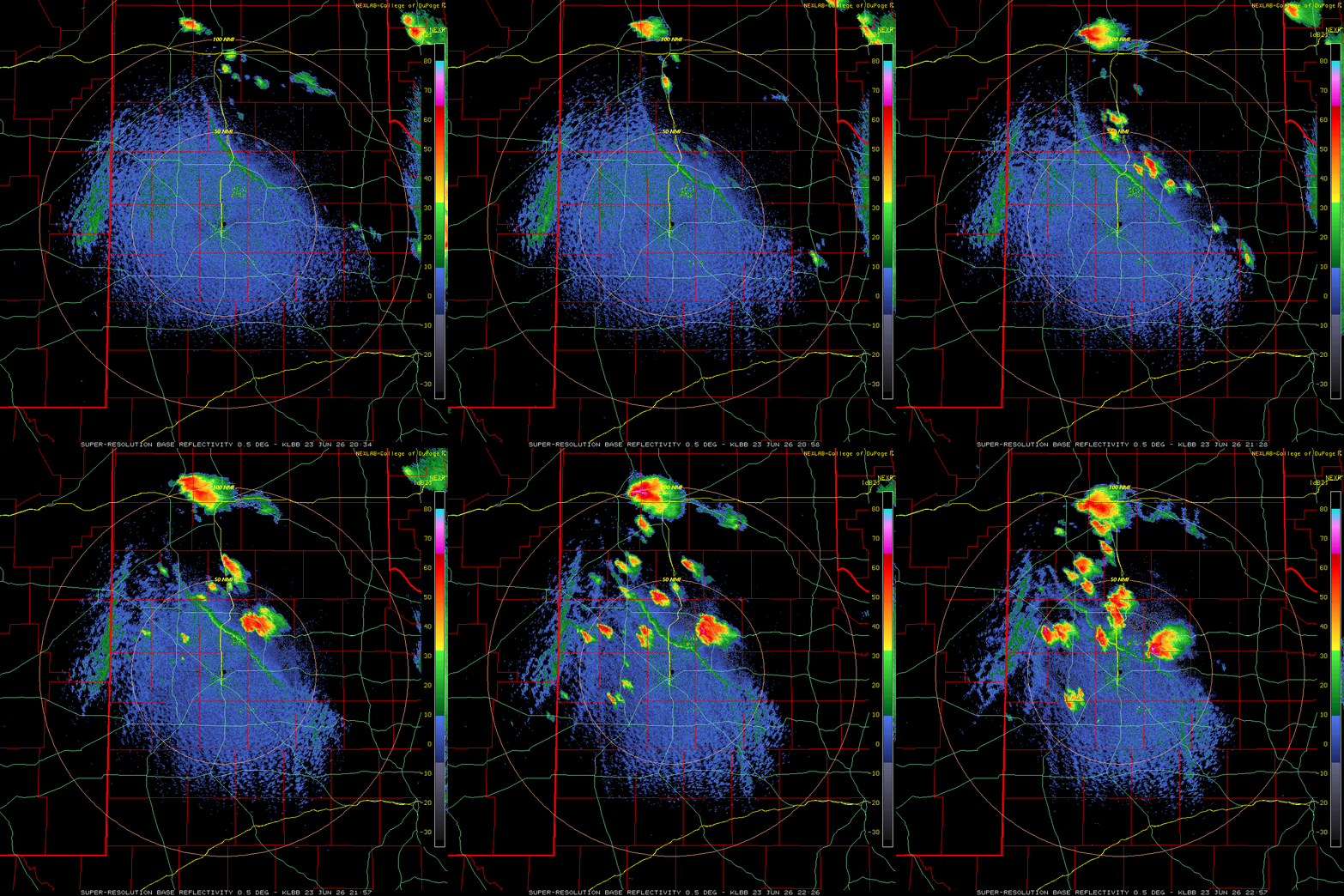
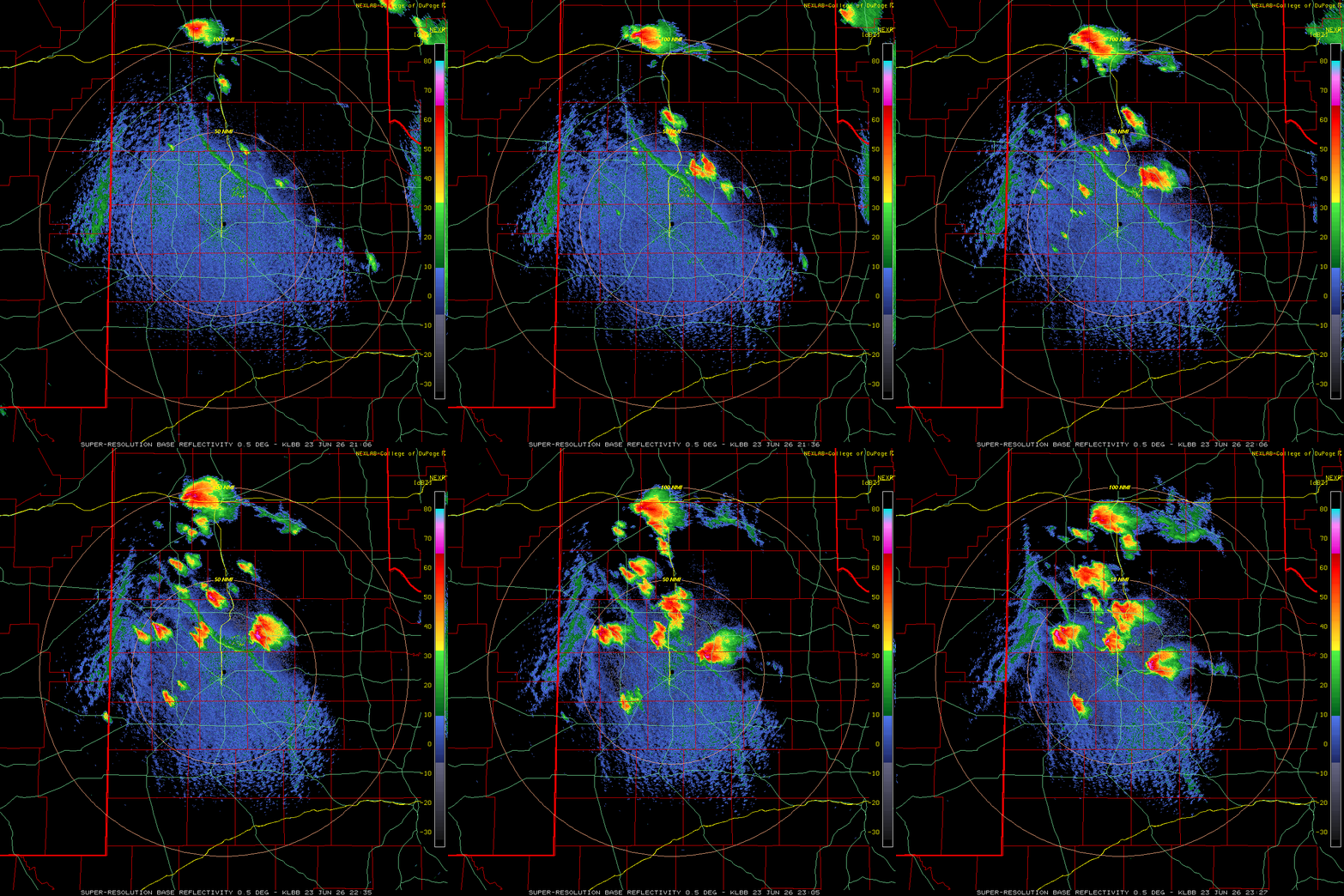
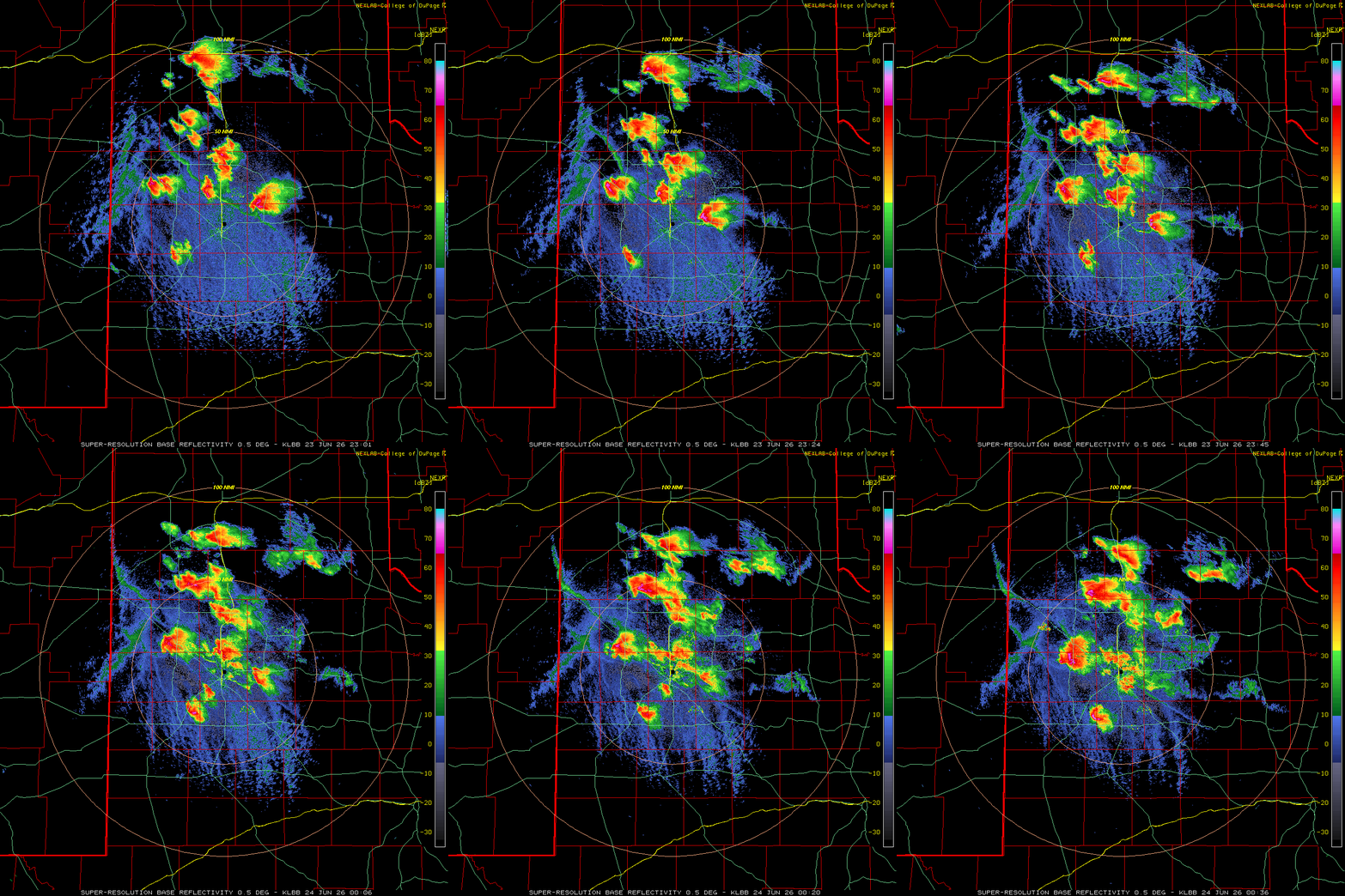
| Lubbock WSR-88D radar animation valid from 6:01 pm to 7:36 pm on Tuesday (23 June 2026). Additional Lubbock radar animations can be found at:3:34 pm to 5:57 pm on Tuesday; and 4:06 pm to 6:27 pm on Tuesday. | |||
| In addition to the hail, severe and damaging wind gusts emanated from the most intense storms. A wind gust as high as 71 mph was measured at the Lubbock Airport, while several other West Texas Mesonet (WTM) sites across the South Plains, Rolling Plains and southern Texas Panhandle measured gusts of 60 to 70 mph. | |||
 |
 |
||
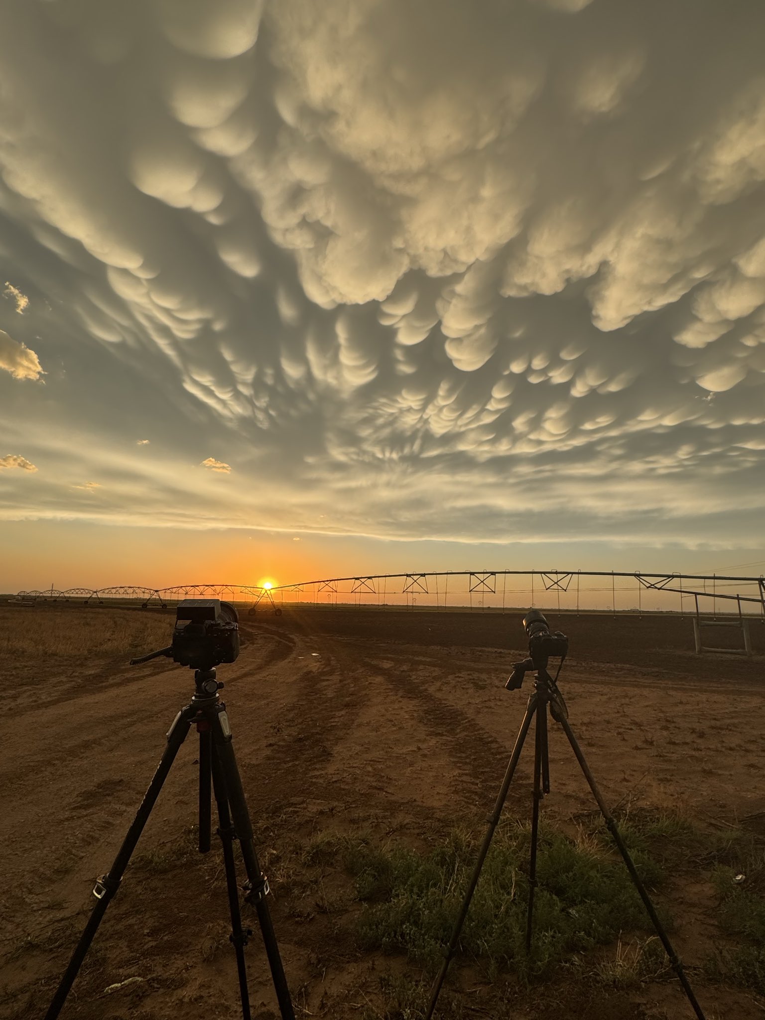
| [left] A beautiful sunset, with illuminated mammatus, near Hale Center on Tuesday evening (23 June 2026). The picture is courtesy of Jim Tang. [right] Thunderstorm wind damage that occurred near Sundown on Tuesday. The image is courtesy of Myriah Baty, relayed by Jacob Riley. | |||
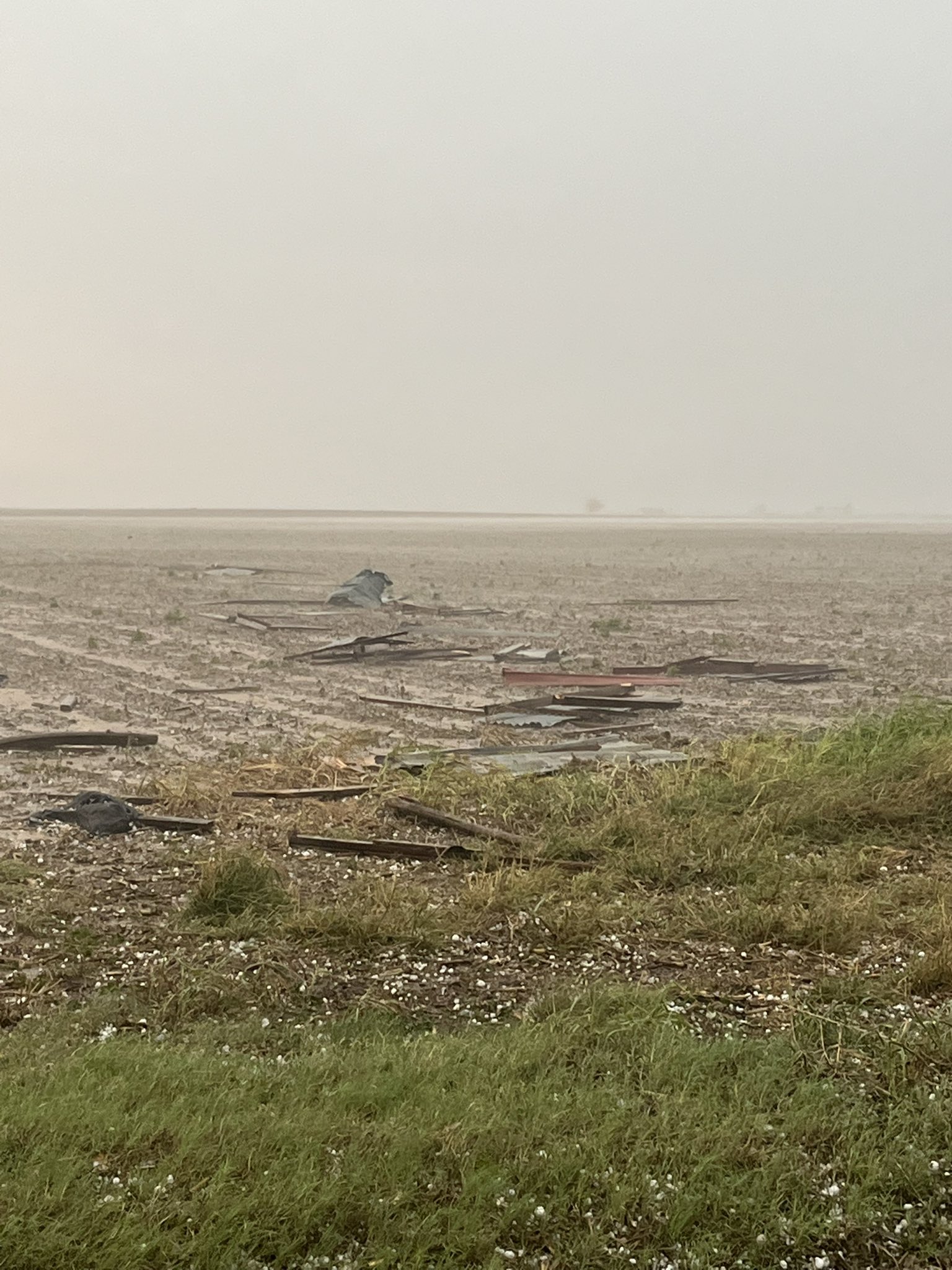
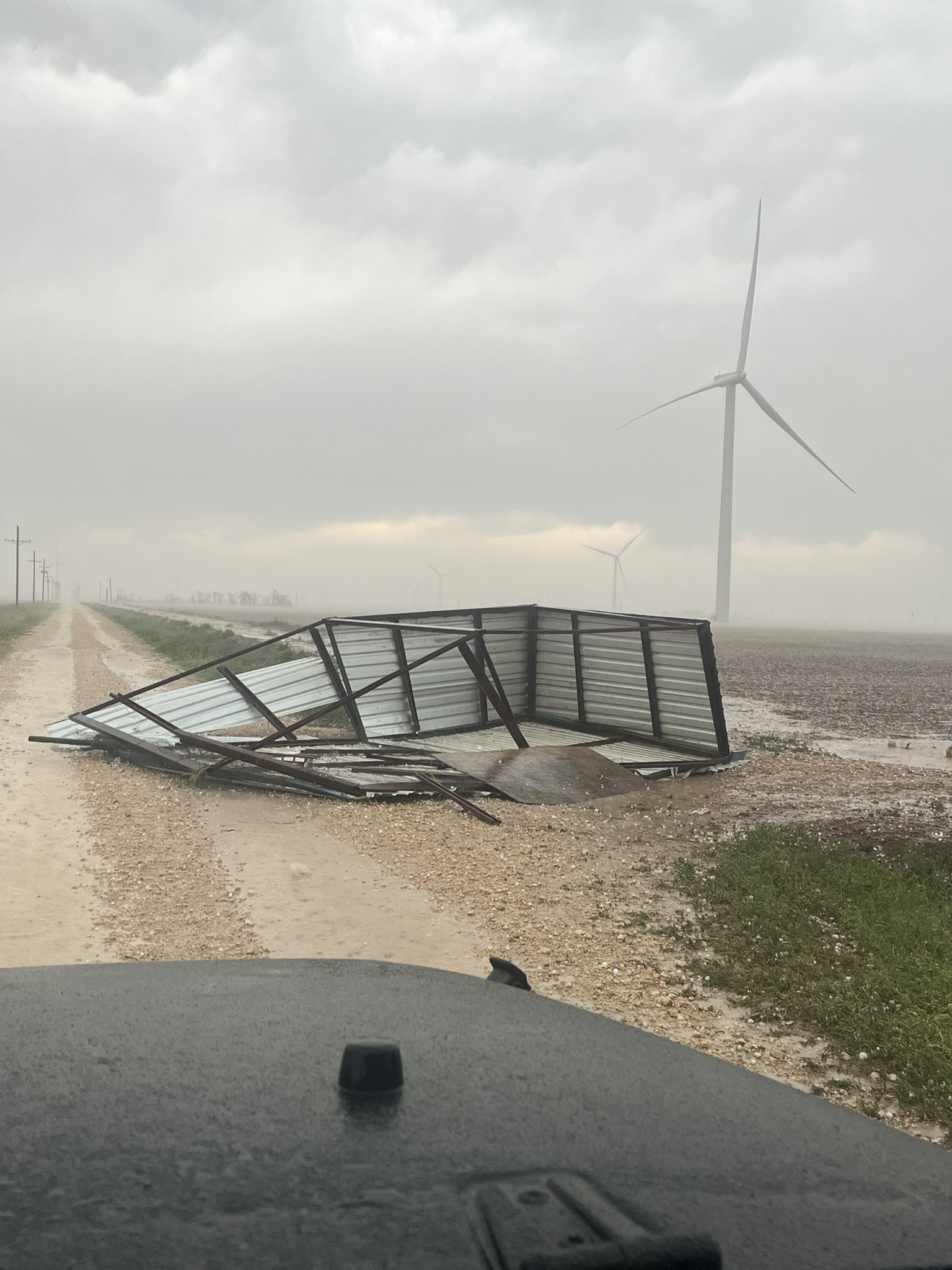
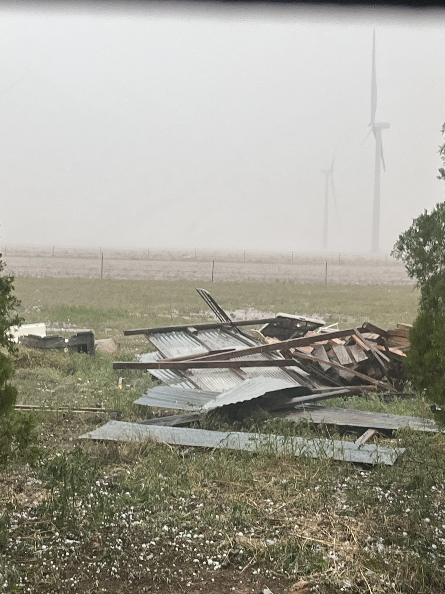
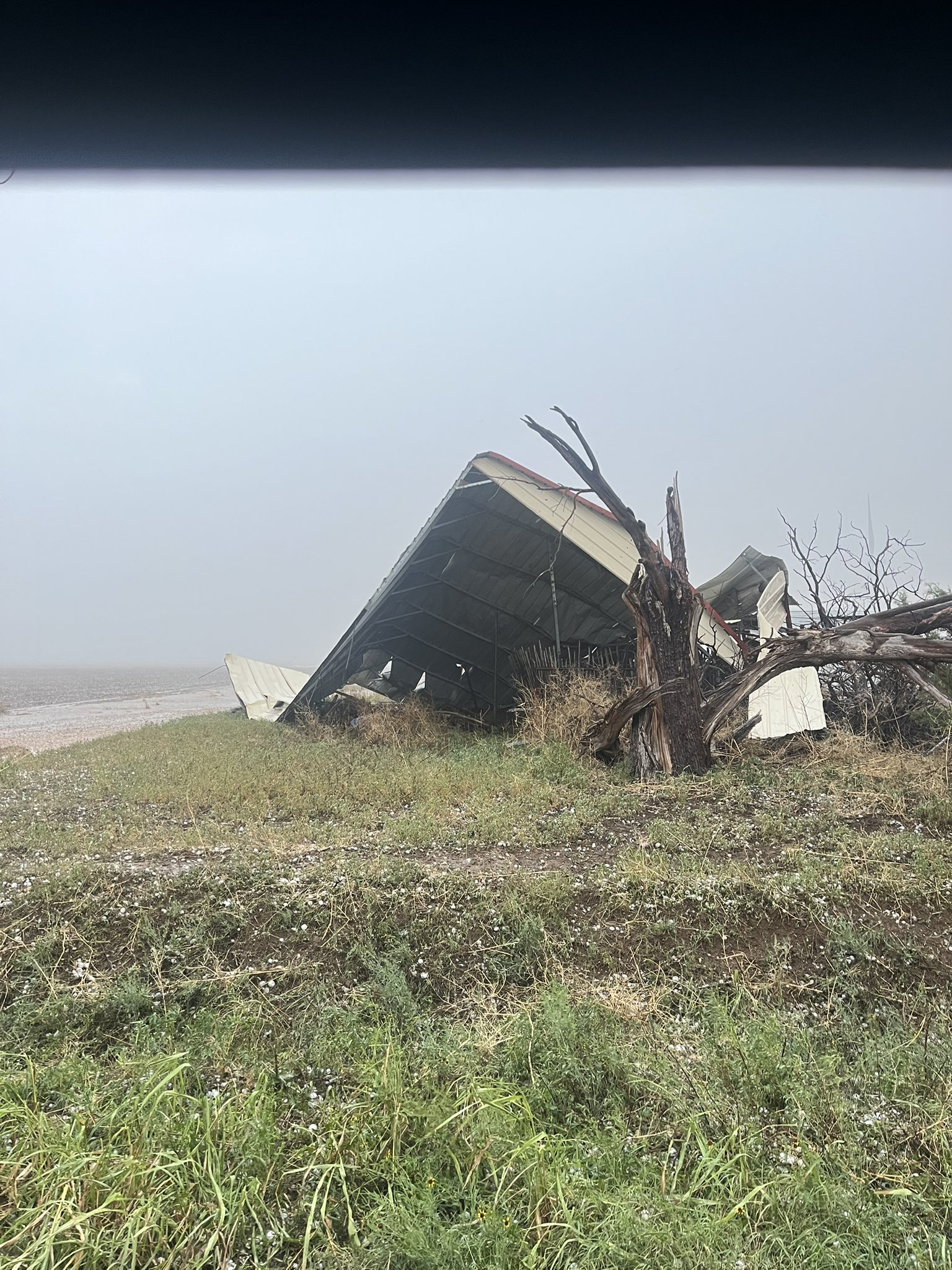
| Unfortunately, the fierce winds inflicted damage in spots, including toppling an RV onto a car near Sundown (see the picture above), tore the roof off a church west of Levelland and damaged or destroyed a couple of outbuildings near Lorenzo (see the pictures below). On the positive side, welcome rainfall did fall in several swaths. | |||
 |
 |
||
| Thunderstorm wind damage near Lorenzo on Tuesday evening (23 June 2026). The images are courtesy of Chris Boger. Two additional pictures of damage, also from Chris Boger, can be viewed HERE and HERE. | |||
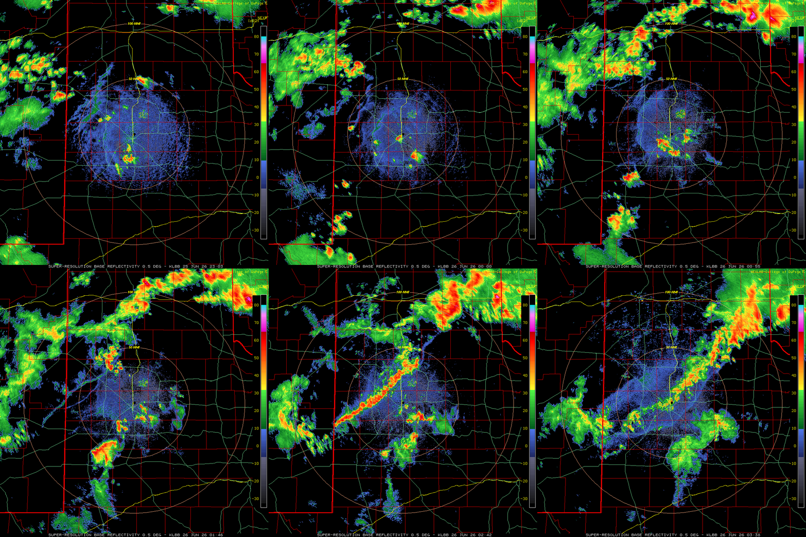
| The next day, Wednesday (June 24th), brought another round of storms to the region. This activity moved out of eastern New Mexico late in the evening, with the most intense storms tracking across the northwestern South Plains and southern Texas Panhandle through the overnight hours. Outflow winds downed trees and power lines in Littlefield shortly after 10 pm, where it also rolled a travel camper, injuring a person in the process. The strongest storm went on to generate a peak wind gust of 74 mph as it passed the Happy WTM site and Vigo Park WTM site shortly after midnight. | |||
 |
|||
| Lubbock WSR-88D radar animation valid from 6:03 pm to 10:38 pm on Thursday (25 June 2026). | |||
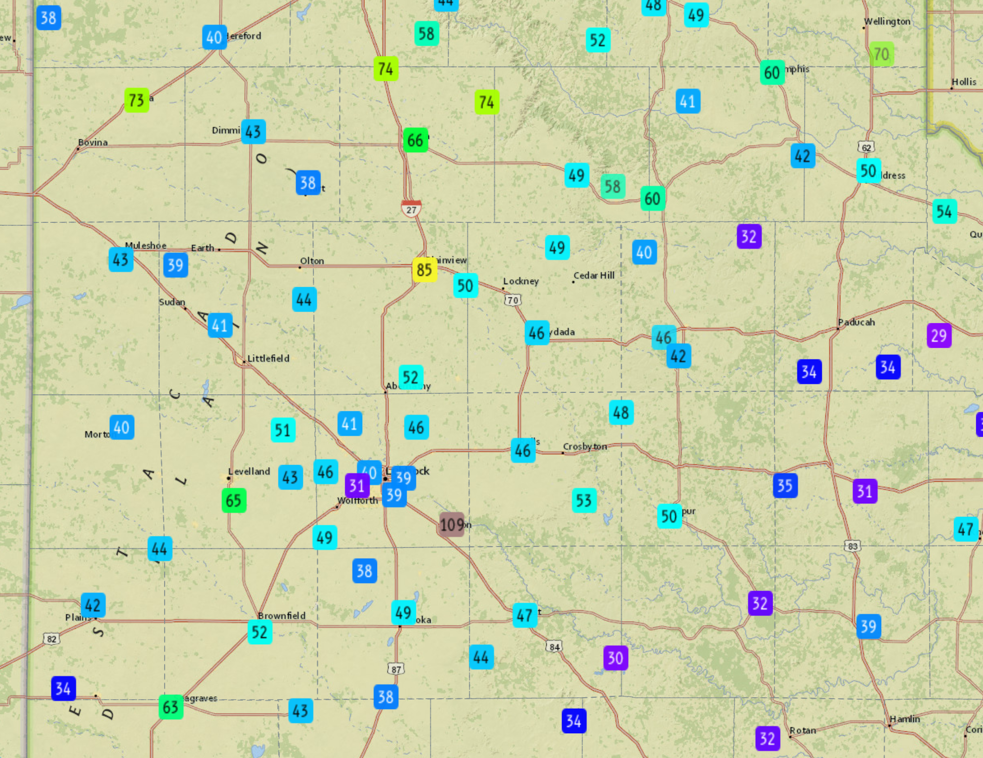
| Following the early morning thunderstorms, and a welcome lull, more numerous storms visited the South Plains region Thursday evening (25 June). Triple digit heat again fueled the initial activity over the central South Plains, while additional storms leaked out of New Mexico. The strongest of the high-based activity generated powerful winds, gusting as high as 73 mph at the Friona WTM, 85 mph at the Plainview WTM and 110 mph at the Slaton WTM! | |||
 |
|||
| Peak wind gusts measured by the West Texas Mesonet (WTM) on Thursday evening (25 June 2026). | |||
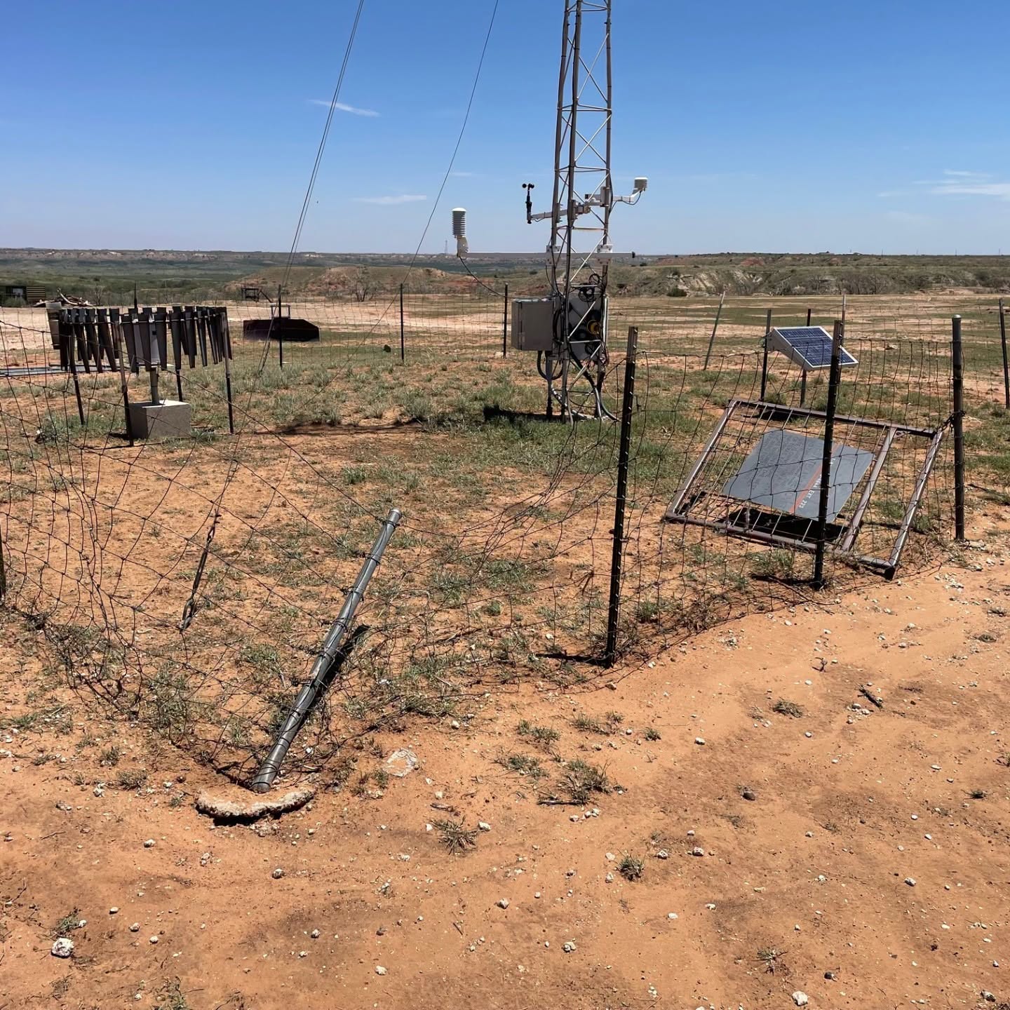
| The severe winds caused damage at the Slaton WTM, as can be seen below. Amazingly, aside from the damage near Slaton, damage reports received by the National Weather Service (NWS) on this active evening were limited. | |||
 |
|||
|
|||
|
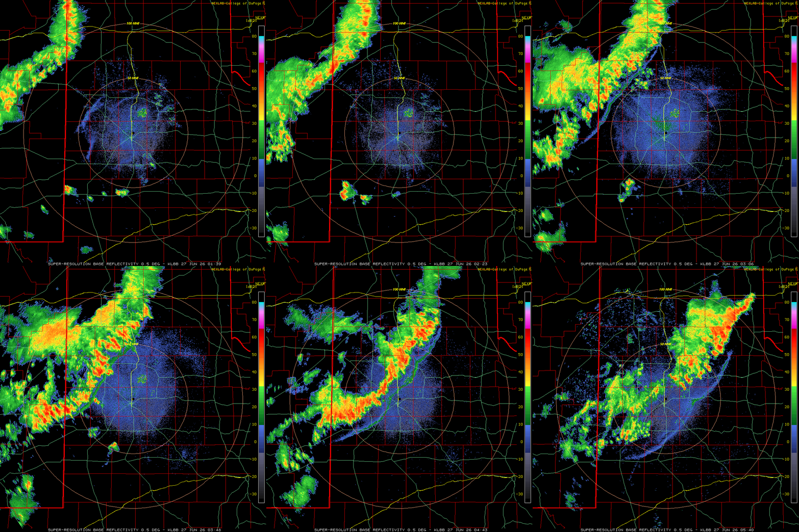
Another day brought another round of thunderstorms, this time a line that moved out of eastern New Mexico late Friday evening (26 June 2026), and swept across much of the region through the overnight hours. |
|||
 |
|||
| Lubbock WSR-88D radar animation valid from 8:39 pm on Friday to 12:40 am on Saturday (26-27 June 2026). | |||
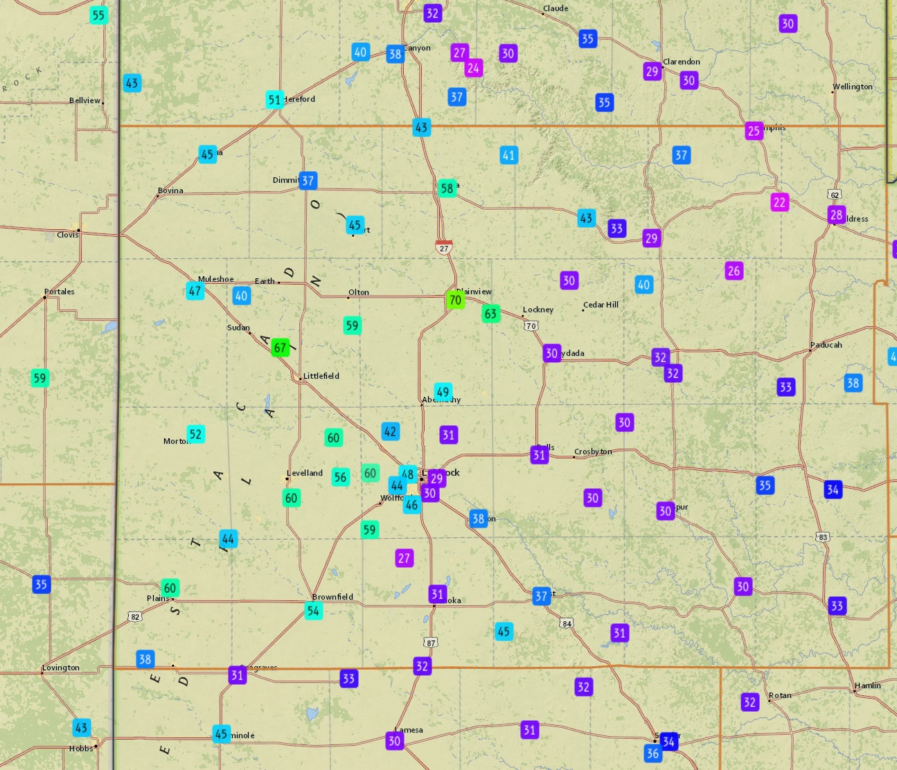
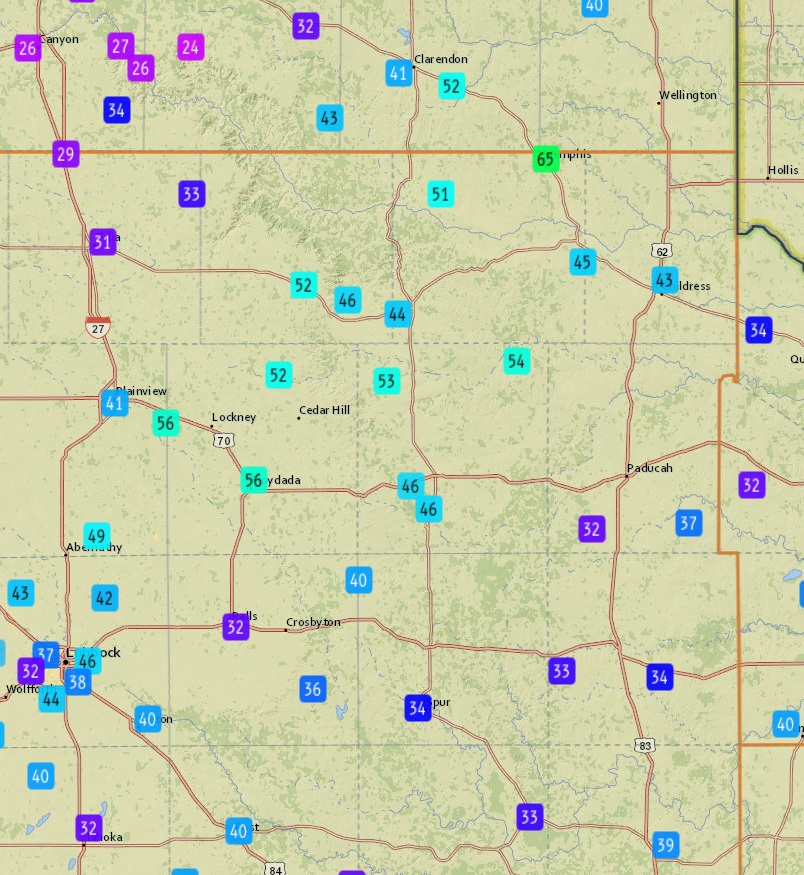
| Strong to severe winds were common with this activity as it traversed the region. Wind gusts from 50 to 60+ mph were measured at many locations, with a peak gust of 70 mph measured by the Plainview WTM. | |||
 |
 |
||
| Peak wind gusts measured by the West Texas Mesonet before (left) and after (right) midnight on Friday night (26-27 June 2026). | |||
|
Shower and thunderstorm coverage and intensity were muted the following few days, though it was not completely quiet. No severe weather was observed during the day or evening on Saturday or at all on Sunday, despite scorching temperatures. |
|||
 |
|||
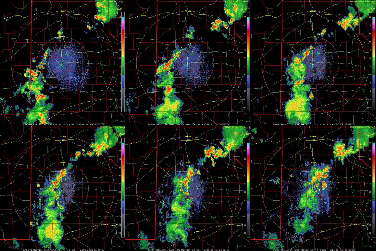
| Lubbock WSR-88D radar animation valid from 7:12 pm to 10:05 pm on Monday (29 June 2026). | |||
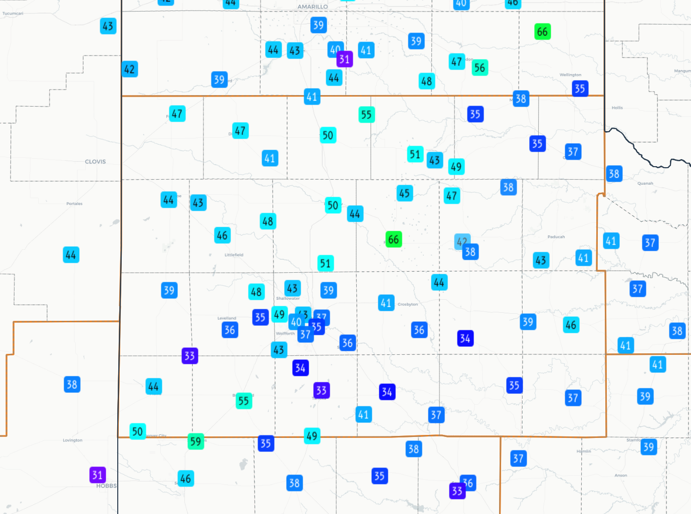
| The pendulum swung back to the more active side on Monday evening (29 June 2026) as a cluster of thunderstorms traversed the central South Plains and southeastern Texas Panhandle. Mostly sub-severe wind gusts (below 58 mph) accompanied this activity, though the Floydada WTM measured a peak gust of 66 mph. | |||
 |
|||
| Peak wind gusts measured by the West Texas Mesonet on Monday (29 June 2026). | |||
|
More intense thunderstorms followed on the final day of June, which brought wind gusts of 60+ mph to the Lesley, Brownfield, Olton, Hart and Wolfforth WTM sites. The peak wind gust of the day was 73 mph, measured near Lesley shortly after 3 pm. In addition to the wind, heavy rain created flooding west of New Home, as well as on the south Loop 289 in Lubbock. Early July brought more of the same, with severe-caliber winds reported in Friona and Post on the 1st, large hail (golf ball size in Dimmitt) and high winds targeting the northwest South Plains on the 4th, and quarter to golf ball size hail impacting the Roaring Springs and Dougherty area on the 5th A list of the preliminary storm reports collected over this active late June and early July stretch can be found below. |
|||
Preliminary Local Storm Report...Summary
National Weather Service Lubbock TX
1047 PM CDT Tue Jun 23 2026

..TIME...   ...EVENT...      ...CITY LOCATION...     ...LAT.LON...
..DATE...   ....MAG....      ..COUNTY LOCATION..ST.. ...SOURCE....
            ..REMARKS..

0104 PM     Tstm Wnd Gst     2 NNE Childress         34.46N 100.20W
06/23/2026  M59 MPH          Childress          TX   Mesonet


0112 PM     Hail             1 NNW Childress         34.44N 100.22W
06/23/2026  M1.75 Inch       Childress          TX   Public


0117 PM     Hail             1 NW Childress          34.44N 100.23W
06/23/2026  M1.75 Inch       Childress          TX   Public


0123 PM     Hail             1 W Childress           34.44N 100.23W
06/23/2026  E0.50 Inch       Childress          TX   Public

            Report from mPING: Half-inch (0.50 in.).

0127 PM     Hail             Childress               34.42N 100.21W
06/23/2026  E1.00 Inch       Childress          TX   Public

            Report from mPING: Quarter (1.00 in.).

0143 PM     Tstm Wnd Gst     11 S Kirkland           34.23N 100.07W
06/23/2026  M68 MPH          Cottle             TX   Public


0204 PM     Tstm Wnd Gst     2 SSE Hackberry         33.90N 100.13W
06/23/2026  M58 MPH          Cottle             TX   Mesonet


0531 PM     Hail             5 SSW Lockney           34.05N 101.46W
06/23/2026  E1.00 Inch       Floyd              TX   Public

            Social media photo from Sandhill area south
            of Lockney. Time estimated from radar.

0535 PM     Hail             1 WSW Sudan             34.06N 102.54W
06/23/2026  E1.25 Inch       Lamb               TX   Public

            Social media report of hail up to half
            dollar size near Sudan. Time and location
            estimated from radar.

0540 PM     Tstm Wnd Gst     4 ESE Petersburg        33.84N 101.54W
06/23/2026  M64 MPH          Floyd              TX   Storm Chaser


0555 PM     Hail             Sudan                   34.07N 102.52W
06/23/2026  M1.00 Inch       Lamb               TX   Public


0619 PM     Hail             3 W Ralls               33.67N 101.43W
06/23/2026  E1.25 Inch       Crosby             TX   Public

            Report from mPING: Half Dollar (1.25 in.).

0624 PM     Hail             3 SE Cotton Center      33.96N 101.96W
06/23/2026  E1.00 Inch       Hale               TX   Public

            Social media photo. Time and location
            estimated from radar.

0629 PM     Hail             1 W Ralls               33.68N 101.40W
06/23/2026  E1.00 Inch       Crosby             TX   Public

            Social media report of a few quarter size
            stones in Ralls.

0649 PM     Tstm Wnd Dmg     3 NE Lorenzo            33.70N 101.50W
06/23/2026                   Crosby             TX   Public

            Barn/shed blown over road and another larger
            one down with the attachment tossed into the
            road.

0656 PM     Hail             Abernathy               33.84N 101.85W
06/23/2026  E1.00 Inch       Hale               TX   Public

            Social media photo. Location estimated from
            radar.

0657 PM     Hail             Abernathy               33.84N 101.85W
06/23/2026  E1.75 Inch       Hale               TX   CO-OP Observer

            Time estimated from radar.

0711 PM     Hail             Meadow                  33.33N 102.21W
06/23/2026  E1.75 Inch       Terry              TX   Public

            Delayed report from social media. Time
            estimated from radar.

0711 PM     Hail             2 SSE Abernathy         33.82N 101.84W
06/23/2026  E1.75 Inch       Lubbock            TX   Public

            Social media photo shows a few stones close
            to golf ball size. Time estimated from
            radar.

0720 PM     Hail             2 SE Hart               34.37N 102.09W
06/23/2026  E0.70 Inch       Castro             TX   CO-OP Observer

            Time estimated from radar. Hail size
            estimated by observer.

0723 PM     Hail             4 E Wolfforth           33.51N 101.94W
06/23/2026  E0.75 Inch       Lubbock            TX   Public

            Report from mPING: Dime (0.75 in.).

0724 PM     Hail             5 S Lubbock             33.52N 101.86W
06/23/2026  E0.75 Inch       Lubbock            TX   Public

            Report from mPING: Dime (0.75 in.).

0736 PM     Hail             2 SE Hart               34.37N 102.09W
06/23/2026  E1.00 Inch       Castro             TX   CO-OP Observer

            Corrects time of previous hail report from 2
            SE Hart.

0737 PM     Hail             1 W Happy               34.73N 101.88W
06/23/2026  E1.25 Inch       Swisher            TX   Public

            Report from mPING: Half Dollar (1.25 in.).

0740 PM     Non-Tstm Wnd Gst 10 WSW Guthrie          33.57N 100.48W
06/23/2026  M58 MPH          King               TX   Mesonet


0741 PM     Non-Tstm Wnd Gst 10 WSW Guthrie          33.57N 100.48W
06/23/2026  M61 MPH          King               TX   Mesonet


0746 PM     Hail             3 S Whitharral          33.69N 102.33W
06/23/2026  E2.00 Inch       Hockley            TX   Public

            Social media photo shows a few irregularly
            shaped stones near 2 inches in diameter.
            Time estimated from radar.

0755 PM     Tstm Wnd Gst     2 SSW Levelland         33.55N 102.37W
06/23/2026  M63 MPH          Hockley            TX   AWOS


0802 PM     Tstm Wnd Gst     4 S Levelland           33.53N 102.36W
06/23/2026  M60 MPH          Hockley            TX   Mesonet


0805 PM     Tstm Wnd Gst     6 S Olton               34.09N 102.12W
06/23/2026  M65 MPH          Lamb               TX   Mesonet


0808 PM     Tstm Wnd Gst     6 S Olton               34.09N 102.12W
06/23/2026  M70 MPH          Lamb               TX   Mesonet


0813 PM     Hail             Levelland               33.58N 102.37W
06/23/2026  M1.75 Inch       Hockley            TX   Public

            Multiple reports of golf-ball sized hail in
            Levelland.

0813 PM     Hail             1 SW Levelland          33.57N 102.37W
06/23/2026  M2.75 Inch       Hockley            TX   Public

            Baseball sized hail reported at Levelland
            Country Club.

0821 PM     Tstm Wnd Gst     4 NNE Shallowater       33.74N 101.97W
06/23/2026  M61 MPH          Lubbock            TX   Mesonet


0833 PM     Hail             1 WNW Levelland         33.59N 102.38W
06/23/2026  E2.50 Inch       Hockley            TX   CO-OP Observer

            Time estimated by radar. Hail size estimated
            by observer.


0834 PM     Tstm Wnd Gst     1 N Lubbock Int. Airpor 33.67N 101.82W
06/23/2026  M71 MPH          Lubbock            TX   ASOS

            Additional gusts ranging from 59 to 66 mph
            from 830 to 840 PM. ASOS station KLBB
            Lubbock.


0840 PM     Tstm Wnd Dmg     6 N Sundown             33.54N 102.49W
06/23/2026                   Hockley            TX   Public

            Camper blown over on top of car. Timing was
            estimated by radar. Occurred sometime
            between 8:30p-8:45p.


0840 AM     Tstm Wnd Dmg     7 W Levelland           33.57N 102.49W
06/23/2026                   Hockley            TX   Public

            Roof on church blown completely off. Time
            estimated from radar. Occurred sometime
            between 8:30p-8:45p.


0926 PM     Hail             Brownfield              33.18N 102.27W
06/23/2026  E1.00 Inch       Terry              TX   CO-OP Observer

            Time estimated by radar. Hail size estimated
            by observer.


0928 PM     Tstm Wnd Gst     8 SW Sundown            33.39N 102.61W
06/23/2026  M59 MPH          Cochran            TX   Mesonet


0930 PM     Hail             Brownfield              33.18N 102.27W
06/23/2026  M1.50 Inch       Terry              TX   Law Enforcement


0937 PM     Non-Tstm Wnd Gst 4 SE Lubbock            33.54N 101.81W
06/23/2026  M58 MPH          Lubbock            TX   Mesonet


0948 PM     Non-Tstm Wnd Gst 2 NE Slaton             33.46N 101.62W
06/23/2026  M59 MPH          Lubbock            TX   Mesonet


1045 PM     Non-Tstm Wnd Gst 1 N O'Donnell           32.98N 101.83W
06/23/2026  M62 MPH          Lynn               TX   Mesonet

            Additional gusts ranging from 58 to 60 mph
            measured from 1042 PM to 1046 PM.



 Follow us on X
 Follow us on Facebook
 Follow us on YouTube
 LUB RSS Feed