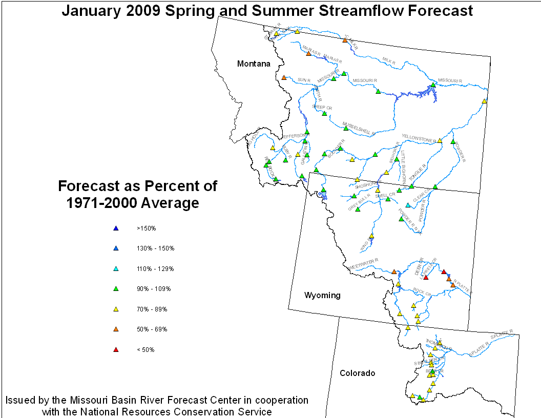
January 1, 2009 Spring and Summer Streamflow Forecasts
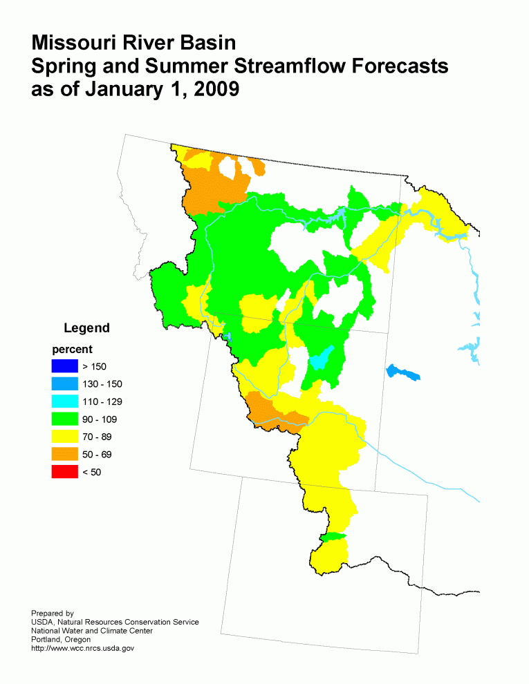

Missouri River Basin Streamflow Forecast Missouri River Basin Mountain Snowpack
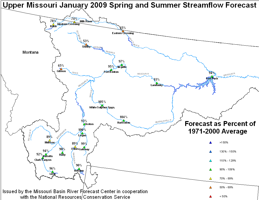
Upper Missouri Basin
The high elevation snow pack in the Upper Missouri Basin as of
January 1 was mainly average to slightly below average.  The snow
pack above Toston,  Montana was 100 percent of average.  The snow
pack between Toston and Fort Peck, Montana was 93 percent.  The
snow pack in the St Mary and Milk river basins was 64 percent.

Fall precipitation across the Upper Missouri basin was mainly
above average with the exception of Milk St. Mary which was below
average. Basin precipitation summaries for the Missouri Basin
include: Milk St. Mary,  74 percent; Milk Canada, 123 percent;
Lower Milk, 166 percent; Above Toston, 111 percent; Toston to
Ft. Peck, 136 percent.


December 2008 Upper Missouri Mean Precip Oct-Dec WY2009 Upper Missouri Mean Precip
Stream flow in the Upper Missouri Basin is forecast to be below average
during the upcoming Spring and Summer.  The St. Mary River is forecast
to have 78 percent of average April-September flows.  Runoff is
expected to range around 95 percent of average for the Missouri Basin
above Fort Peck, Montana.  Forecasts for the Milk River Basin call for
around 70 percent of average Spring/Summer runoff.
Upper Missouri January 1, 2009 Spring and Summer Streamflow Forecasts
Of the four major irrigation reservoirs in Montana: Lima Reservoir
had 99 percent average storage, Clark Canyon was holding 70 percent of
average water, Gibson Reservoir had 92 percent of average stored
water, and Fresno Reservoir had 104 percent of average stored water.
The major hydroelectric reservoirs in Montana (Canyon Ferry and
Fort Peck) had monthend storage in the average to below average
range; 99 and 67 percent of average water, respectively.
The U.S. Geological Survey long term gaging station, on the Marias
River near Shelby, Montana had an estimated 44 percent of average
runoff in December.
Yellowstone Basin
The high elevation snow pack in the Yellowstone Basin was about
average on January 1.  The snow pack in the Upper Yellowstone
Basin was 97 percent of average. The snow packs in the Wind,
Bighorn, and Shoshone Basins were 95, 96, and 84 percent of
average, respectively.  The snow packs in the Tongue and Powder
basins were 111 and 106 percent of average, respectively.


Precipitation during October through December ranged from average
to above average.  The range was from 149 percent of average
in the Bighorn River Basin to 100 percent of average in the lower
Yellowstone River Basin.  The upper Yellowstone River Basin received
119 percent of average precipitation while the Wind River Basin
received 106 percent of average.  The Little Bighorn and Powder
River basins were in the average range.


Stream flow in the Yellowstone Basin is forecast to be average
during the upcoming Spring and Summer.  Runoff at
Billings, Montana is expected to be 91 percent of average, with
a probable range between 65 and 117 percent of average.  Stream
flow for the Wind-Bighorn Basin above St. Xavier, Montana is
forecast to be 89 percent of average with a probable range
of 41 to 134 percent of average flow in sub-basins.  Flow in the
Tongue Basin is expected to be 104 percent of average with
a reasonably likely range of 57 to 152 percent of average flow.
Flows in the Powder River are expected to be about 100 percent of
average with a reasonably likely range of 42 to 158 percent of
average.

Yellowstone January 1, 2009 Spring and Summer Streamflow Forecasts
Platte Basin
The high elevation  snow pack in the Upper North Platte basin was
85 percent of average on January 1.  The snow pack in the North
Platte  Basin below Seminoe  Reservoir was 74 percent of average.
The snow pack in the South Platte Basin was 97 percent of average.

Fall precipitation across the Platte Basin was below average.
Fall precipitation in the North Platte Basin above Seminoe
Reservoir was 82 percent of average. In the North Platte Basin
between Seminoe Reservoir and Guernsy Reservoir precipitation
was 72 percent of average. The North Platte Basin below Guernsy
Reservoir had 68 percent of average fall precipitation.  The high
elevations of the South Platte Basin had 79 percent of average
fall precipitation whereas the plains had 81 percent of average
October-December precipitation.


December 2008 Platte Mean Precip Oct-Dec WY2009 Platte Mean Precip
Stream flow in the Platte basin is forecast to range from below
average to above average during the upcoming spring and summer.
Runoff for streams above Seminoe Reservoir are expected to be about
75 to 90 percent of average.  Stream flows for the North  Platte
below Seminoe Reservoir are forecast to be 40 to 90 percent of
average.


North Platte Streamflow Fcst South Platte Streamflow Fcst
Stored water in the South Platte Basin as of January 1 was 95 percent
of average.


