Several rounds of thunderstorms are expected through the overnight hours, especially southwest of Madison. They are not expected to be severe, but some gusty winds (<56 mph) are still possible. Showers and storms will then taper off early in the morning.
The flash flood risk will remain during the overnight hours as thunderstorms continue to track over the same areas toward the Illinois border. A Flash Flood Watch remains in effect for most of southern Wisconsin through mid- morning. The greatest risk for heavy rainfall and flooding is across areas southwest of Madison, especially Iowa and Lafayette Counties.
Check the radar frequently, have a way to receive warnings, and keep up with the latest forecast.
Here are some flooding and severe weather safety tips.
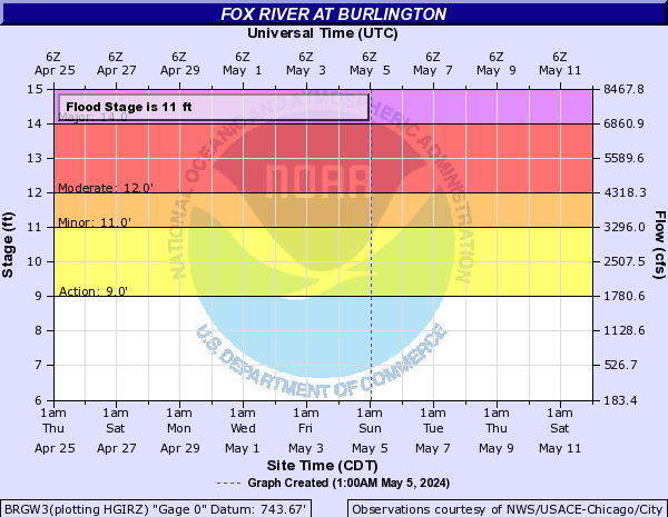
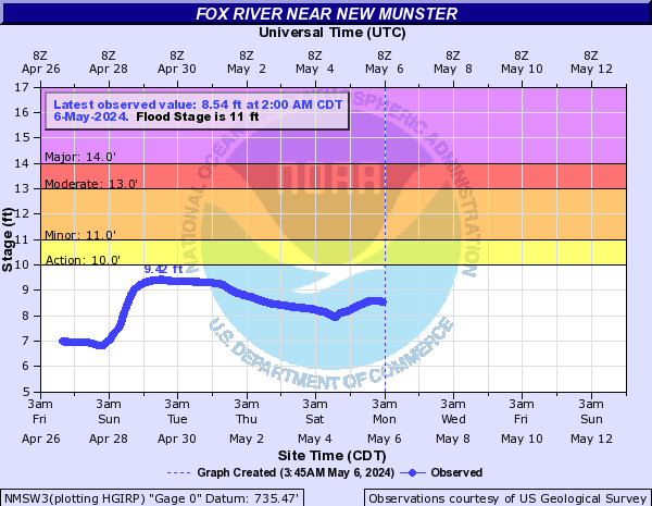
Many area rivers are either exceeding flood stage, or are forecast to exceed flood stage, overnight and for the next several days. The main rivers that are experiencing or forecasting flooding include the Baraboo, Rock, Sugar, Pecatonica, Turtle Creek and Root River Canal.
Areas in far southeast Wisconsin that experienced flooding earlier in the week are likely to see more river flooding over the next several days. The Fox River at Burlington is forecast to rise again, likely exceeding flood stage again by Sunday or Monday. The Fox River at New Munster remains over flood stage, and is likely to rise again through Monday night or Tuesday.
Here are the hydrographs (including river stage forecasts) for these two river gauge locations:
| Fox River At Burlington | Fox River Near New Munster |
 |
 |
Click here for river stage information and forecasts across the area.
| Weather Story | Weather Headlines |
 |
 |
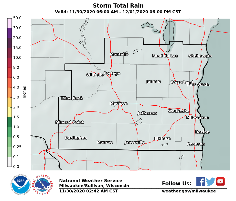
Here are the expected rainfall amounts through midday Saturday. Localized areas could see much more, due stronger storms. The axis of heaviest rainfall looks to be across northeast Iowa, southwest Wisconsin and into northern Illinois.
| Southern Wisconsin | Wisconsin |
 |
 |
...Regional Radar Views...
 |
 |
...Local Radar...

...Assessing Past Rainfall Across The Area...
Recent rainfall was heavy over far southern and southwest Wisconsin. The two images below highlight the radar-estimated rainfall from Wednesday evening through early Thursday morning, and also over the past 14 days.
| Wednesday Evening into Early Thursday Morning |
Past 14 Days (Ending Thursday) |
 |
 |
All of this rain has created saturated soil conditions roughly south of a Kenosha to Baraboo line. This will make these areas more at risk for additional flooding from any heavy rainfall, especially for areas southwest of Madison.
You can also see from the 14 day total image that areas north of Milwaukee, and up through Green Lake Counties, have escaped much of the torrential rainfall. They will be in better shape to absorb a heavy rainfall.
...Warm & Humid Conditions Saturday...
The warm and humid conditions will bring heat index values into the middle to upper 90s Saturday across southern and western parts of Wisconsin. Here are some heat safety tips.
...Severe Weather Hazards And Reporting Guidelines...
Main Hazards:
If you get severe weather, send us your report!
See below on what and how to report severe weather to us:

...Storm Prediction Center Severe Weather Outlooks...
| Tonight | Saturday/Saturday Night |
 |
 |
| Sunday | Interpreting These Outlooks |
 |
 |
...Links Of Interest...
Local Storm Report Graphic
Local Storm Report Text
SPC Local Storm Reports
Submit a Storm Report
Hazardous Weather Outlook
Forecast Discussion
Severe Thunderstorm Warnings
Tornado Warnings
Flash Flood Warnings
Severe Weather Statements
SPC Meso-Analysis Page
Our Severe Weather Page
Wood/Cronce
NWS Milwaukee/Sullivan, WI


 Follow us on YouTube