
Hurricane Eloise - September 23, 1975
 On September 13th of 1975, Eloise slowly formed into a tropical depression east of the Lesser Antilles. The tropical depression slowly intensified over the next few days and became the 5th tropical storm of the 1975 season early on the 16th of September. Atmospheric conditions quickly became more ideal for intensification. Eloise rapidly developed into a hurricane late on the 16th before moving across the northern part of the Dominican Republic and Haiti.
After striking the Dominican Republic, Eloise weakened into a tropical storm as it continued on a path off to the west across the Caribbean Sea through the 20th of September. Eloise began to turn and regain strength as it moved through the Yucatan channel. By the time Eloise reached the central Gulf, it had regained hurricane strength. By midday on the 22nd, Eloise strengthened into a Category 2 hurricane and began turning toward the northeast on a path straight toward the north-central Gulf Coast. The pressure continued to drop over the next 12 hours, and Eloise strengthened into the 2nd major hurricane of the 1975 season by midnight on the 23rd. In fact, there was a 22mb drop in 12 hours (between 18z on the 22nd to 06z on the 23rd) as bombogenesis ensued with a 35mb drop in 24 hours. The satellite image to the right shows Hurricane Eloise the afternoon before landfall (as bombogenesis was ongoing in the cyclone).
Strengthening continued until Eloise made landfall as a major hurricane about 10 miles east of Fort Walton Beach, FL (Okaloosa County) at approximately 7am CDT on the 23rd. According to the NOAA Assessment, Herbert Saffir estimated winds in excess of 120mph based on the structural wind damage he observed in Eloise. Shortly after Eloise made landfall, a peak wind gust of 115mph was recorded at Eglin AFB (before the instrument failed) with 85mph gusts at Hurlburt Field. Eloise rapidly weakened as it pushed inland across Alabama through the day.

Photo courtesy of NOAA, Office for Coastal Management, DigitalCoast
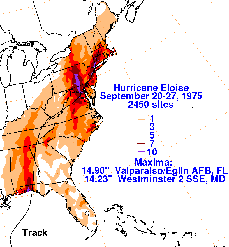 In general, rainfall ranged from 3-5 inches across the area with higher amounts closer to the track of Eloise. The highest rain totals occurred just east of the track of the center of the storm. It was estimated that 6-10 inches of rain fell across the northwest Florida panhandle with isolated higher amounts. The observer at Eglin Air Force Base reported 14.9 inches of rain during Eloise. Flooding was reported all across the northwest Florida panhandle with flash flooding noted in the Pensacola, FL area. River flooding also occurred on the Yellow River near Milligan, FL. This rainfall depiction can be viewed in the WPC graphic to the right.
Wind damage from Eloise was widespread across the northwest Florida panhandle and further inland across southern portions of Alabama and Georgia. There was extreme tree and crop damage all along the path of Eloise. In Alabama, the State Civil Defense estimated agricultural losses in excess of 100 million dollars. Thousands of trees were toppled and utility lines were knocked down across the area. 85-90% of the buildings between Fort Walton Beach and Panama City, FL (on the Gulf side of Highway 98) were severely damaged or destroyed. At least 150 buildings were destroyed or unrepairable, 75 motel foundations were destroyed and 400 other buildings were damaged in that area.
Storm surge was extensive along the coast with observations of storm tide (storm surge + tide) as high as 10.6 feet in Destin, FL with higher values further to the east of the track of Eloise. Eloise severely damaged several piers across the panhandle, including the destruction of the relatively newly built Okaloosa Island Pier. Beaches were destroyed and dunes were undermined. 30-70 feet of sand dune width was eroded during Eloise. Storm surge washed away structures and streets across northwest Florida, as can be seen in the before and after photos below. More than 30 boats moored in Destin, FL were destroyed or sunk with some reportedly "stacked like toys" according to the NOAA Assessment.


Before and After Storm Damage Photos from the Northwest Florida Panhandle
Eloise was the first major hurricane to strike the region in 4 decades, yet did not have any fatalities directly related to the storm. However, there were 4 fatalities reported across Florida and Alabama, indirectly related to Eloise. The 2 deaths in Alabama occurred after the storm, from a tree falling during clean-up operations and electrocution from a downed power line.

WPC Archive
NOAA Natural Disaster Survey Report - Hurricane Eloise
Monthly Weather Review - Atlantic Hurricane Season of 1975
NOAA Digital Coast - Hurricane Eloise Track
Acknowledgements: Page created by Morgan Barry (forecaster).
LAST UPDATED: September 2025

