
Hurricane Juan - October 31, 1985
 On October 24th in the year 1985, a trough of low pressure, which would eventually turn into Juan, slowly formed over the central Gulf. One day later, the low pressure system strengthened into a tropical depression. On the morning of the 26th, Juan continued to steadily strengthen and became a tropical storm. At this time, Juan had many of the characteristics of a subtropical storm with the band of strongest winds well away from the center of Juan and rather erratic movement.
By the afternoon of the 27th, Juan strengthened into a hurricane. Visible satellite imagery of Hurricane Juan on the afternoon of the 28th can be seen on the right. As Juan continued to approach the Louisiana coast for its first landfall, it executed an interesting pretzel-shaped track. Juan made landfall for the first time on the morning of the 29th near Morgan City, LA, only to re-emerge into the Gulf just offshore Vermillion Bay on the 30th as a tropical storm. Juan became a little more organized as it skirted along the coast of Louisiana as it meandered toward the east and then to the northeast.
Juan made its second landfall near Gulf Shores, AL midday on Halloween (October 31st). Juan finally turned north and accelerated through the Midwest and into southern Canada.
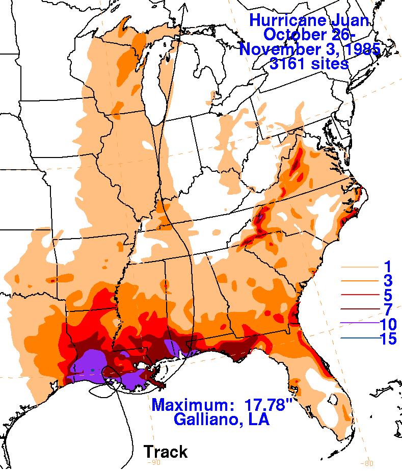
Juan will be known for its unusual track across the southeastern US and its very heavy rainfall across Louisiana, Mississippi, Alabama, and Florida. Juan dropped 10-12 inches of rain across the area, as seen in the WPC rainfall graphic below. During Juan, some of the higher rainfall totals across our area were 12.23 inches in Fairhope, AL, and 11.71 inches in Pensacola, FL. Some of the worst flooding occurred on the 29th (before landfall) when more than 5 inches fell across Mobile and Baldwin Counties in southwest Alabama.
Much of the damage across the region was due to a combination of storm tides and heavy rain. Topsoil losses were reported as heavy, and some farmers estimated that 50% of the soybean crop was lost in Juan. The pecan crop, which took a hard hit during Hurricane Elena the month prior, sustained additional losses when the nuts (ready for harvest) floated away. Minor to moderate beach erosion due to storm surge occurred
WPC Archive
Monthly Weather Review - Atlantic Hurricane Season of 1985
NOAA Digital Coast - Hurricane Juan Track
Acknowledgements: Page created by Morgan Barry (forecaster).
LAST UPDATED: August 2025

