On this page you learn what types of flooding are typical in Alabama and how do you protect yourself, your family and your home. You will also find out more about significant Alabama floods. Finally, you'll find links to NWS offices that provide forecast and safety information for Alabama, as well as links to our partners who play a significant role in keeping you safe.
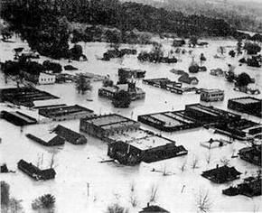
Some of the most severe flooding occurred on the Pea River at Elba where a crest of 43.28 feet was measured. A levee constructed around Elba was overtopped by a small stream the morning of the March 17, creating a 175 yard break in the levee that quickly flooded the town. More than 1,500 people were evacuated with no loss of life. Of the city's 140 businesses, 130 were either destroyed or severely damaged. Over 1,000 homes in the area were also flooded.
On the Choctawhatchee River, a record crest of 40.32 feet occurred at Newton the morning of March 18, exceeding the crest of 39.4 feet that occurred in March 1929. Considerable residential and commercial flooding occurred in the vicinity of Newton and Daleville, with several evacuations necessary. Further downstream at Geneva, the river crested at 38.54 feet the afternoon of March 19 and flooded 450-500 homes outside of a levee built to protect the town. This crest was second only to the crest that occurred in the flood of March 1929.
Murder Creek in Brewton crested some 10 feet above flood stage late on the March 17. This flooded a large portion of Brewton and East Brewton to depths of 4-6 feet.
The Alabama River at Montgomery crested almost 20 feet above flood stage, causing widespread street, residential and commercial flooding in the area. Over 500 homes were evacuated in the Montgomery area, with 200-250 homes affected by flood waters on the Millbrook side of the river. Catoma Creek, which flows into the Alabama River near Montgomery, crested almost 10 feet above flood stage, causing widespread street, residential and commercial flooding in Montgomery's southern suburbs.
At Selma, the Alabama crested at 54.75 feet on the 21st, about a foot below its flood of record. Over 1,700 homes were affected by flood waters in Dallas County.
Severe flooding also occurred on portions of the Coosa and Tallapoosa Rivers, with residential flooding in the vicinities of Gadsden, Childersburg, Wetumpka and the Tallapoosa Water Plant.
Total flood damage was estimated at $120 million in current U.S. dollars.
 |
 |
| Flooding in Elba during March 1990 | Flooding in Elba during March 1990 |
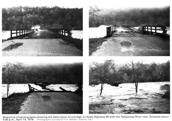
A storm system approaching Alabama on the April 11 brought extreme rainfall to the area during the next 2 days. By the morning of the 13th, four to eight inches of rain were common in north Alabama, with totals as high as 10-15 inches in the western counties. Heavy rain continued through the morning of the 13th, shifting south and east, with 4 to 5 inches falling over Lake Martin in approximately two hours before noon. By mid-afternoon, most of the rain had moved east of the area.
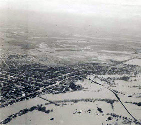
Record or near record crests occurred along much of the Tombigbee, Black Warrior and Sucarnoochee Rivers with severe residential and commercial flooding in areas such as Tuscaloosa, Demopolis, Gainesville and Livingston. Thousands of acres of farm lands, woodlands, and pasture lands were flooded, as well as numerous camps and cabins along these rivers.
Widespread signficiant, but less severe, flooding occurred on many area rivers, including the Alabama, Coosa, Tallapoosa and Cahaba Rivers, with some residential flooding occurring in the vicinities of Montgomery, Gadsden and the Tallapoosa Water Plant.
When all the floodwaters had receded, damage was estimated at $75 million with at least 15 deaths in the state.
 |
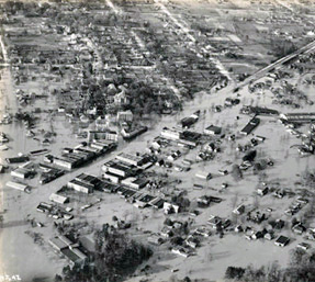
| Flooding on the Tombigbee River at the Highway 80 Bridge west of Demopolis April 19, 1979 |
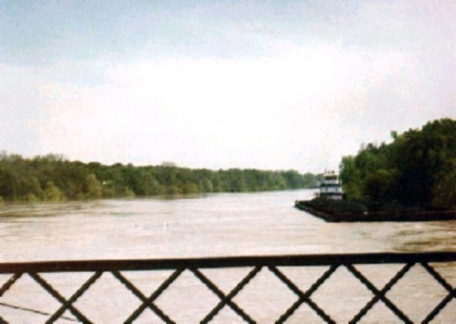 |
| Flooding on the Tombigbee River at the Highway 80 Bridge west of Demopolis April 19, 1979 |
Tropical Storm Alberto moved ashore in the Florida Panhandle on July 3 then moved slowly north-northeast to near Atlanta during the next few days before meandering back south and west into Alabama. During this time, the storm produced rainfall of 15-20 inches over portions of extreme Southeast Alabama, and 5-10 inches over portions of the Tallapoosa and Conecuh River basins. This rainfall resulted in major flooding along the Choctawhatchee and Pea River, with less severe flooding along the lower portion of the Tallapoosa River, the lower Conecuh River and Catoma Creek near Montgomery. Over 1,000 homes and businesses were either damaged or destroyed in Coffee, Dale, Henry, Geneva and Houston counties as the Choctawhatchee and Pea Rivers overflowed their banks.
Many points along the Choctawhatchee River measured near record crests. At Newton, the river crested at 37.95 feet, making it the third highest crest recorded there. At Geneva, the river crested at 42.42 feet, making it the second highest crest. The Pea River at Elba crested at 38.33 feet, making this the third highest crest recorded there.
When the high waters had receded, 10 Alabama counties had been declared disaster areas. Two deaths and over $112 million in damages were attributed to the flooding in Alabama.
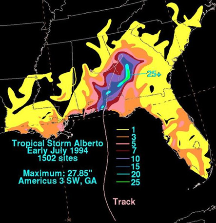 |
| Storm Total Rainfall for Tropical Storm Alberto |
 |
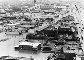 |
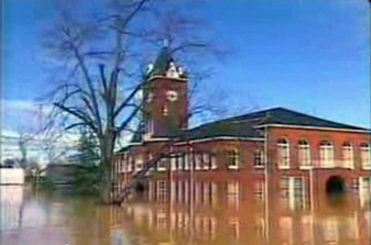
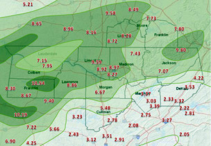
| Rainfall Totals from March 14-16, 1973 | Flooding along Huntsville Spring Branch and Memorial Parkway on March 16, 1973 |
For more on this flood, visit A Look Back at the Floods of March 1973
|
||||||