The Black Hills area can experience spectacular temperature variations. Day-to-day changes occur as cold and warm fronts cross the northern Plains. However, temperature ranges across the area at a given time can be just as great. They happen rapidly as the wind direction changes, most notably the warming Chinook winds that have given the Black Hills the reputation as the “Banana Belt” of the Midwest. Other temperature differences are caused by inversions, when warm air flows over a shallow pool of cold air. Because the Black Hills rise above the plains like an island in a body of water, they are in the warm air layer.
The most notable temperature fluctuations occurred on January 22, 1943 when temperatures rose and fell almost 50 degrees in a few minutes. This phenomenon was caused when a frontal boundary separating extremely cold Arctic air from warmer Pacific air rolled like an ocean tide along the northern and eastern slopes of the Black Hills.
In mid-January 1943, Arctic air pushed southward from Canada, bringing extremely cold temperatures across the central United States. By the morning of January 19, temperatures were well below zero as far south as Kansas and in the single digits to teens across Texas. On January 20, warmer air started to spread eastward from the Pacific over the Rockies while lows ranged from -20 to -30 degrees across the Dakotas (see map below). The boundary separating this warmer air from the frigid air was near the front range of the Rocky Mountains and through Nebraska, with Casper WY at 22 degrees while Rapid City was -20 degrees. During the day, the warm air aloft reached the higher elevations of the Black Hills. Temperatures warmed into the 30s at Custer and Lead while highs remained below zero in downtown Rapid City, the Rapid City Airport (now Ellsworth Air Force Base), and Spearfish. The following day, temperatures reached the 40s in the Hills but struggled to get into the single digits above zero on the plains as the front advanced to the northeast.
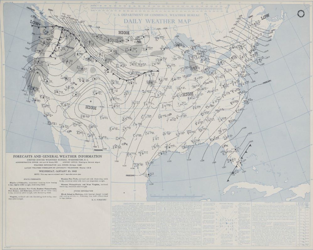
Daily Weather Map from the morning of January 20, 1943
Early morning temperatures on January 22 were already above freezing in the higher elevations of the Black Hills but still below zero along the foothills. Shortly after daybreak, the front moved northeast—down the slopes of the Black Hills—and temperatures warmed rapidly. Later in the morning, the front retreated to the southwest and temperatures plummeted just as quickly. The oscillations occurred several times during the morning; the front pushed east of Rapid City during the afternoon, allowing the airport to reach 50 degrees. It finally shifted south again during the late afternoon, and the cold air returned to the foothills.
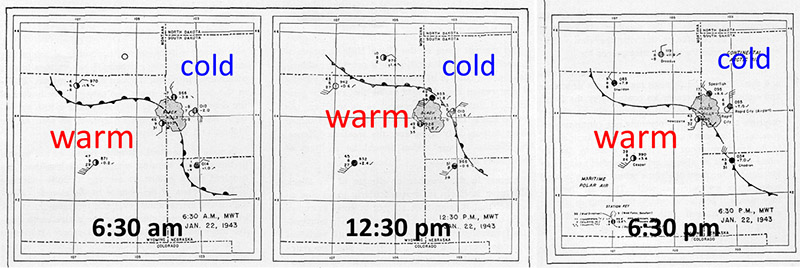
Weather maps showing the position of the front around the Black Hills on January 22, 1943 (from Monthly Weather Review, March 1943)
In Spearfish, the temperature rose from -4 at 7:32 a.m. to 45 degrees–a rise of 49 degrees—in just two minutes. A couple of hours later, it plunged from 54 back to -4 degrees–a change of 58 degrees in 27 minutes. In downtown Rapid City, the temperature had warmed to +5 degrees by 9:20 a.m., then it quickly warmed to 54 degrees by 9:40 am—a difference of 49 degrees in 20 minutes.
The drastic temperature changes were logged on recording thermometers at the Montana-Dakota Utilities Company offices in both downtown Rapid City (then at 725 St. Joseph Street) and Spearfish. A picture of the instrument with a replica of the January 22, 1943 chart is shown below along with a picture of the actual temperature recording chart.
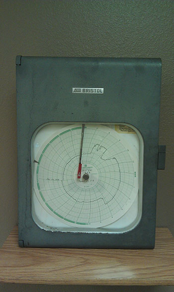
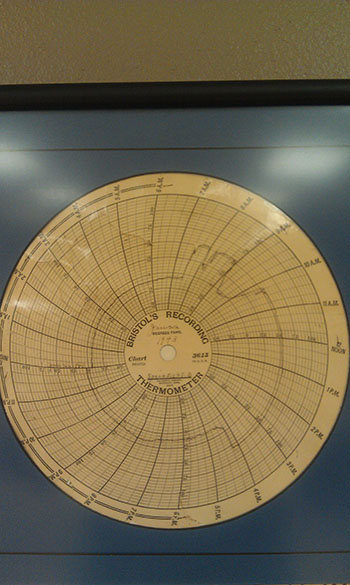
The recording thermometer and temperature chart from Spearfish on January 22, 1943 (photos courtesy of Montana-Dakota Utilities Company)
The change in temperature was noticeable as people rounded street corners. Motorists were unable to see out their windshields when thick frost forms as they encountered the front and plate glass windows cracked.
This event, which the Rapid City Daily Journal described as “crazily deviating temperatures” and “freakish warmth”, received national media coverage. It was featured in “Ripley’s Believe it or Not” and “Strange as it Seems” cartoons printed in newspapers across the country.
A detailed description of the event was written by Roland R. Hamann, Senior Observer with the U.S. Weather Bureau office (now National Weather Service) at Rapid City, South Dakota and published in the March 1943 Monthly Weather Review as “The Remarkable Temperature Fluctuations in the Black Hills Region January 1943” available here: https://www.weather.gov/media/unr/historical/mwre-1520-0493_1943_71_29_trtfit_2_0_co_2.pdf.


 Follow us on YouTube