National Oceanic & Atmospheric Administration (NOAA) Weather Radio is a nationwide network of radio stations operated by local National Weather Service offices. The continuous broadcasts provide current weather warnings, forecasts, and conditions and is the best method to receive severe weather warnings. When forecasters issue warnings for tornadoes, severe thunderstorms, and flash floods; special receivers sound a tone which alert people even if they’re sleeping, outdoors, watching satellite TV, don’t live near a warning siren, or the electricity is off. The tone alarm will also be used to notify people about other emergencies; such as wildfires, hazardous materials spills, or terrorist activities for which people need to take immediate action to protect themselves. Even during quiet weather, you can tune into your local NOAA Weather Radio station for forecasts to help you plan your day.
Although scanners, hand-held, and mobile radios can be programmed to receive the weather radio broadcast, special receivers are needed to receive the alerts. They can be purchased at electronics, discount, sporting goods, or hardware stores. You can also order them from catalogs specializing in outdoor equipment, weather-related items, or ranch and farm supplies. The cost of a receiver ranges from $30 to $100. You should ensure the model you purchase has battery backup. You may need an external antenna depending on the construction of your building or your location inside it or if you’re in an area of marginal reception. Some radios have an extra jack for a visual signal for hearing impaired people or use in a high-noise area. The NOAA Weather Radio homepage provides a list of weather radio receiver manufacturers.
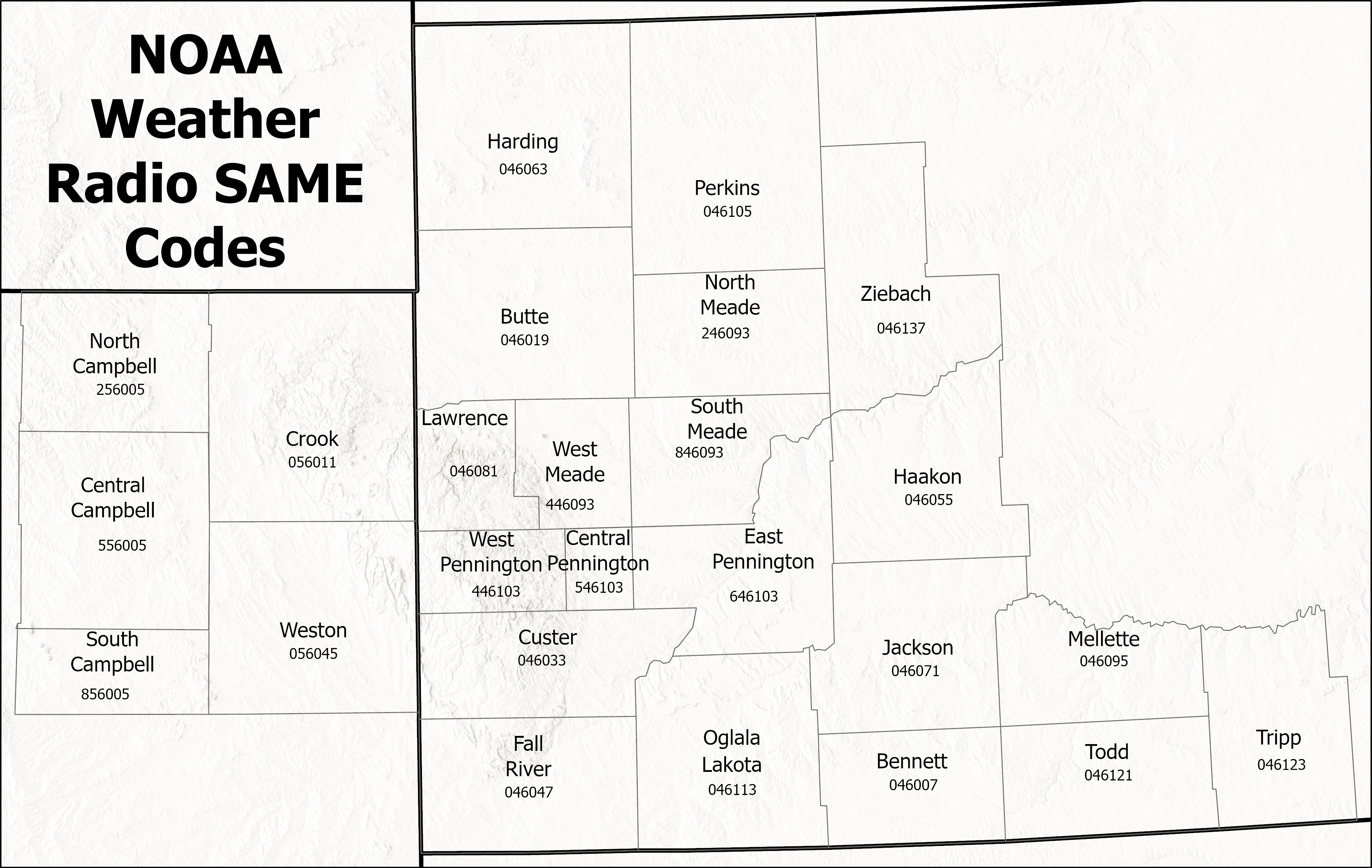
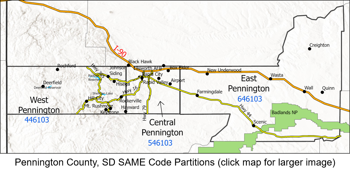
Programmable weather radio receivers allow you to set the county or counties for which you want to receive warnings and block out alerts for storms that won’t affect you. The feature is called SAME, for Specific Area Message Encoding. When programming your SAME weather radio receiver, you may want to add a neighboring county if you live near the county line. For example, Belle Fourche residents may want to receive warnings for Crook County (Sundance). This will only work if the adjacent county is included on the same NOAA Weather Radio transmitter, so residents of Sturgis cannot receive warnings for Lawrence County (Deadwood) on the Rapid City transmitter.
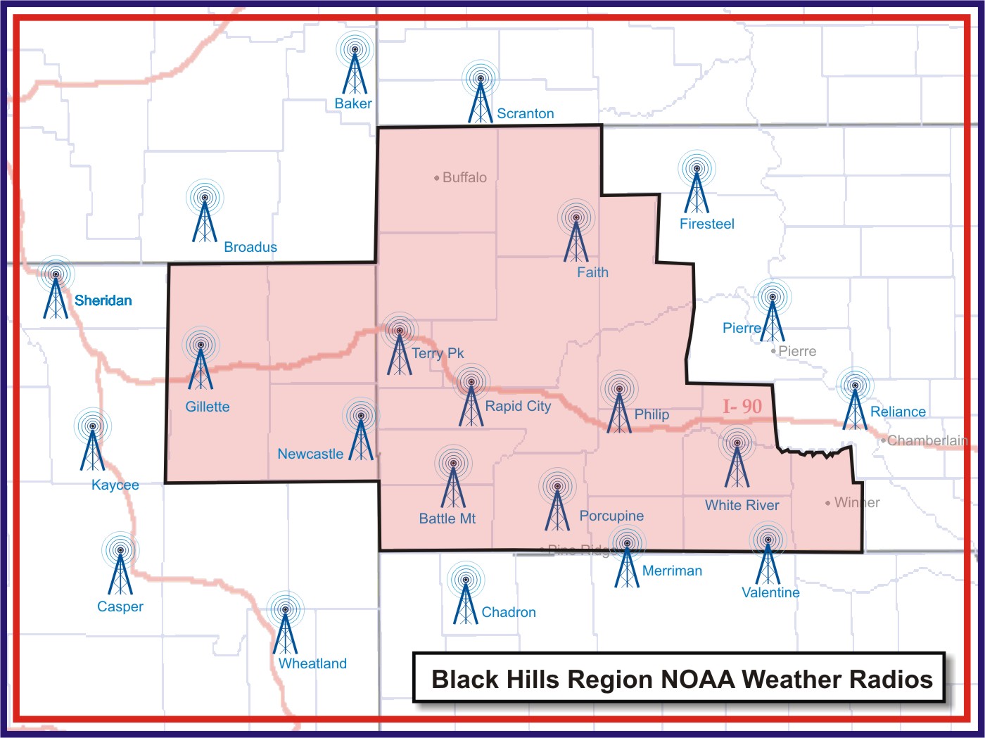
Sixteen NOAA Weather Radio transmitters serve the Black Hills region of western South Dakota and northeastern Wyoming. The locations, frequencies, alert areas, SAME codes, and links to detailed coverage maps for the transmitters are listed below.
BAKER, MT (WXK-57) on 162.550 MHz is programmed by the Billings NWS office and serves:
BATTLE MOUNTAIN near Hot Springs (WXK-64) on 162.425 MHz serves the southern Black Hills:
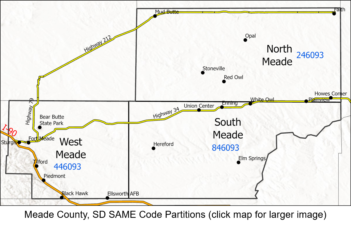
FAITH (WNG-557) on 162.475 MHz serves northwestern South Dakota:
FIRESTEEL, SD (WNG-551) on 162.425 MHz is programmed by the Aberdeen NWS office and serves north central South Dakota, including:
GILLETTE (WNG-660) on 162.500 MHZ serves northeastern Wyoming (click on map to the right for a larger image): 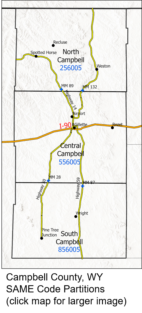
MERRIMAN, NE (WXL-76) on 162.400 MHz is programmed by the North Platte NWS office and serves:
NEWCASTLE (WNG-661) on 162.475 serves the western Black Hills:
PHILIP (KXI-59) on 162.450 MHz serves west central South Dakota:
PORCUPINE (KZZ-59) on 162.500 MHz serves southwestern South Dakota:
RAPID CITY (WXM-63) on 162.550 MHz serves the central Black Hills and plains around Rapid City (click on the maps for larger images):
RELIANCE, SD (KZZ-60) on 162.525 MHz is programmed by the Aberdeen NWS office and serves south central South Dakota, including:
SCRANTON, ND (WNG-658) on 162.525 MHz is programmed by the Bismarck NWS office and serves:
SHERIDAN, WY (WXM-46) on 162.475 MHz is programmed by the Billings NWS office and serves:
TERRY PEAK near Lead (WXL-23) on 162.525 MHz serves the northern Black Hills, northwestern South Dakota, and northeastern Wyoming:
VALENTINE, NE (WXN-82) on 162.450 MHz is programmed by the North Platte NWS office and serves:
WHITE RIVER (WNG-558) on 162.550 MHz serves parts of south central South Dakota:
Other NWR stations serving South Dakota
Other NWR stations serving Wyoming
To find out if NOAA Weather Radio broadcasts are available at your home, office, or travel destination; visit the NOAA Weather Radio homepage.
A list of SAME codes for the entire United States is available on the National Weather Service's NOAA Weather Radio web page or by calling 1-888-697-7263.
The NOAA Weather Radio broadcast provides local forecasts, current weather conditions, and storm warnings. The program for each transmitter is tailored to its broadcast area–a range about 40 miles–to limit the number of alerts issued. The information is repeated every four to six minutes, depending on the weather situation. Sometimes, especially during winter storms, the cycle is longer; during severe thunderstorms and flash flooding, the cycle is shorter to give you critical information more quickly.
The following information is available on NOAA Weather Radio all the time, unless preempted by higher priority weather warnings.
Regional Weather Synopsis: A description of the weather features that will affect the northern Plains through the next few days.
Local Forecast: A forecast of precipitation, sky condition, high and low temperatures, and wind for the next 7 days.
Hourly Weather Roundup: Current temperatures, sky condition, precipitation, and wind at local weather stations; general temperatures and weather conditions for stations around the area and region.
The following information is available during specific times:
Climate Summary: Temperature, precipitation, and wind data for local automated weather stations. The Rapid City Regional Airport and National Weather Service office summaries also include the normal and record temperatures and monthly and yearly precipitation totals. Plays from 7 to 9 AM and 7 to 9 PM each day.
Grassland Fire Danger Statement: Today’s predicted fire danger for the western South Dakota prairies. Plays daily from April through October; and only if the fire danger is high, very high, or extreme from November through March.
Watches, warnings, and advisories are broadcast as necessary during storms.
* Indicates the weather radio alert is used
Hazardous Weather Outlook: Describes the area and timing of potential severe thunderstorms, winter storms, high winds, and excessive heat during the next seven days.
* Severe Thunderstorm & Tornado Watches: Information on potential severe thunderstorms and tornadoes. Watches are typically in effect for four to eight hours.
* Severe Thunderstorm & Tornado Warnings: Information about severe thunderstorms and tornadoes, including area affected by the storms. Warnings are usually valid for 30 minutes to an hour with information updated every 15 to 20 minutes.
* Flood Watches: Information on the potential for flash flooding. Watches are typically in effect for six to 12 hours for flash flood situations; 12 to 36 hours for other flooding.
* Flash Flood Warnings: Information about actual flash flooding, including creeks, rivers, and areas affected by the flooding. Warnings are usually valid for one to six hours with information updated every one to two hours.
Flood Statements: Issued for minor flooding on city streets and underpasses or along creeks or to provide updated information about flood warnings.
Winter Storm Watches, Warnings, Advisories & Outlooks: Information on winter storms; including blizzards, heavy snow, and ice storms. Updated every three to six hours as the storm progresses.
High Wind Watches, Warnings, & Advisories: Information on wind storms. Updated every six to twelve hours.
* Flood Warnings: Information on flooding along rivers and creeks due to heavy rain, snowmelt, or ice jams.
* Non-Weather Emergency Message: Information about wildfires, chemical spills, explosions, radioactive releases, or terrorist activities and protective actions people need to take. The information is provided by local emergency managers.
Air Pollution Alerts: Issued for dust or smoke that elevates pollution levels in Rapid City and blowing dust over Campbell County, Wyoming.
* Weather Radio Weekly Alarm Test: A test of the NOAA Weather Radio warning signal. Conducted every Wednesday between 1100 AM and Noon Mountain Time (Noon and 100 pm Central Time) unless severe weather is occurring.
Public Information Statement: Provides information on new products and services from the National Weather Service, seasonal safety information, and unusual or interesting weather conditions.
If you want to make comments on what you hear on NOAA Weather Radio, you may e-mail the Rapid City National Weather Service or write to:
National Weather Service
Attn: NOAA Weather Radio
300 East Signal Drive
Rapid City, SD 57701
Please include the station you listen to, your location (direction and distance from a town), type of receiver you use (weather radio, scanner, amateur radio, two-way or mobile radio, and/or external antenna) and the quality of the signal.


 Follow us on YouTube