
Severe thunderstorms are forecast across parts of the central and southern Great Plains Thursday afternoon through Thursday night, posing a risk for severe winds and large hail. Hazardous heat will continue across portions of South Texas and for much of the central and southern Florida Peninsula through the weekend. Daily high temperature records could be tied or broken. Read More >
|
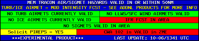
ZME TRACON BRIEFING
CWSU closed between 9:00 PM and 5:15 AM...CWAs will not be updated after 9:00 PM...page will auto-refresh every 5 minutes.. Overnight Briefing Daytime Briefing TRACON Briefing Loop Situational Awareness/Webcams
|
Go to New Page with correct radar zoom
| Update ⇒ Pause/Play Last Frame |  |
 |
 |
Flight Category: VFR MVFR IFR LIFR |
Weather Shading: Convective Freezing Winter Smoke/Ash Liquid Fog/Haze |
The above loop uses radar and visible/IR satellite data obtained from Aviation Weather Center (AWC), lightning (GLM) data from NOAA nowCOAST, and observations (for flight category and weather) from MesoWest. The radar, lightning, visible satellite, IR satellite, and flight categories/weather can be toggled on/off. When both the flight category and weather are displayed, the flight category icon will be on the inside and the partially-transparent weather color on the outside. Clicking on the map will start/stop the loop. Left-clicking on the "Speed" area will slow the loop and right-clicking will accelerate the loop, ranging from 0.05 to 5 second interval. Additional URL parameters include lt (center latitude), ln (center longitude), zm (zoom level, 0-12), nolabel (removes flight category icon ID labels), wide (thicken US state boundaries), and start (UTC start date/time, YYYYMMDDhhmm format, AWC data goes back up to 2 days, GLM data up to 5 hours). The URL should auto-update with the current settings, allowing for an easy bookmark/favorite.
TRACON PAGES: Memphis Nashville NW Arkansas Little Rock Huntsville Jackson

