
Wildfire smoke continues to impact air quality from the Great Lakes region into New England and the Mid-Atlantic today with widespread Air Quality Alerts in effect. Severe thunderstorms are expected across portions of the Ohio Valley and Lower Great Lakes into the Mid-Atlantic and Northeast, this afternoon into the evening. Monsoonal thunderstorms may bring areas of flooding to the Southwest. Read More >
April 29th-30th Heavy Rain and Lakeshore Flooding
 |
| A map of rainfall reports from Tuesday, April 28th, 2020 to Thursday, April 30th, 2020 |
Several rounds of heavy rain moved into Southwest and West-Central Michigan on Tuesday evening, April 28. While the heaviest rain tapered off to showers for much of the area by Wednesday morning, rain continued nonstop through Wednesday evening along and west of US-131.
While this rain overwhelmed storm drains around the area and caused significant rises on rivers, an even more significant impact unfolded along the lakeshore where high Lake Michigan levels flooded roads and eroded bluffs. Water from Lake Michigan also pushed back up river channels and created significant flooding along many of the river mouth lakes in West Michigan. Official water level measurements in Holland and Ludington both measured top 5 water levels ever recorded, with records going back more than 120 years.
River Flooding
Heavy rain and General Flooding: 3-4 inches of rain falling over a continuous 24 hour period resulted in ponding of water across the 3 counties that bore the brunt of the heavy rain. This included several closed roads in each county, as well as some minor flooding around some inland lakes, including Crockery Lake in Ottawa county. Also in Ottawa county, multiple homes in Spring Lake Township experienced several feet of water in basements as drainage systems couldn’t keep up with the continuous heavy rain.
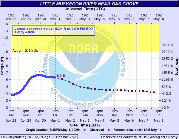
River Flooding: With the heaviest rain falling in Ottawa, Muskegon, and Newaygo Counties, the rivers in these areas saw the most dramatic rises in water levels. This included the Muskegon River and White River basins, as well as the lower portions and tributaries to the Grand River.
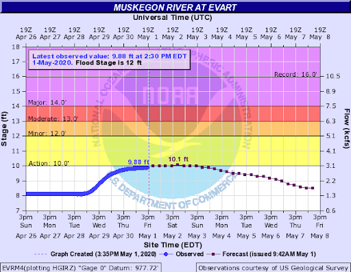
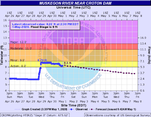
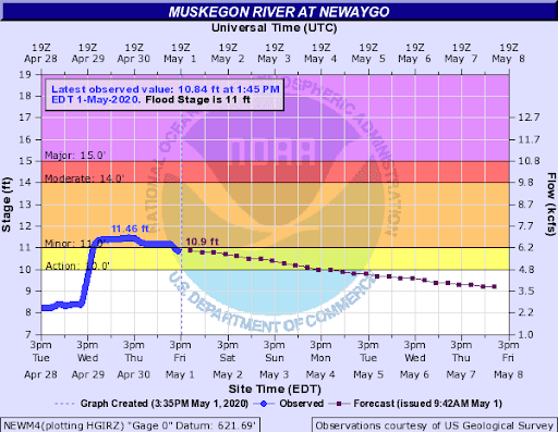
Muskegon River Basin: By Wednesday afternoon, the amount of water flowing down the Muskegon River pushed levels to near flood stage at Croton Dam, and above flood stage at Newaygo and Bridgeton. Several roads and yards were flooded, with the water getting close to a few homes for a while before water started to fall by Thursday afternoon.
 |
 |
 |
 |
 |
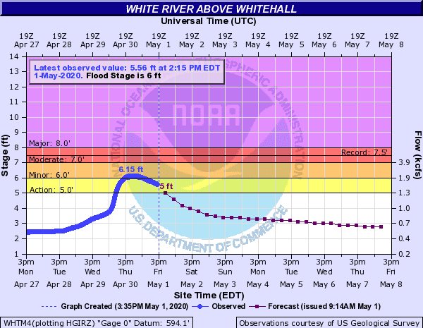
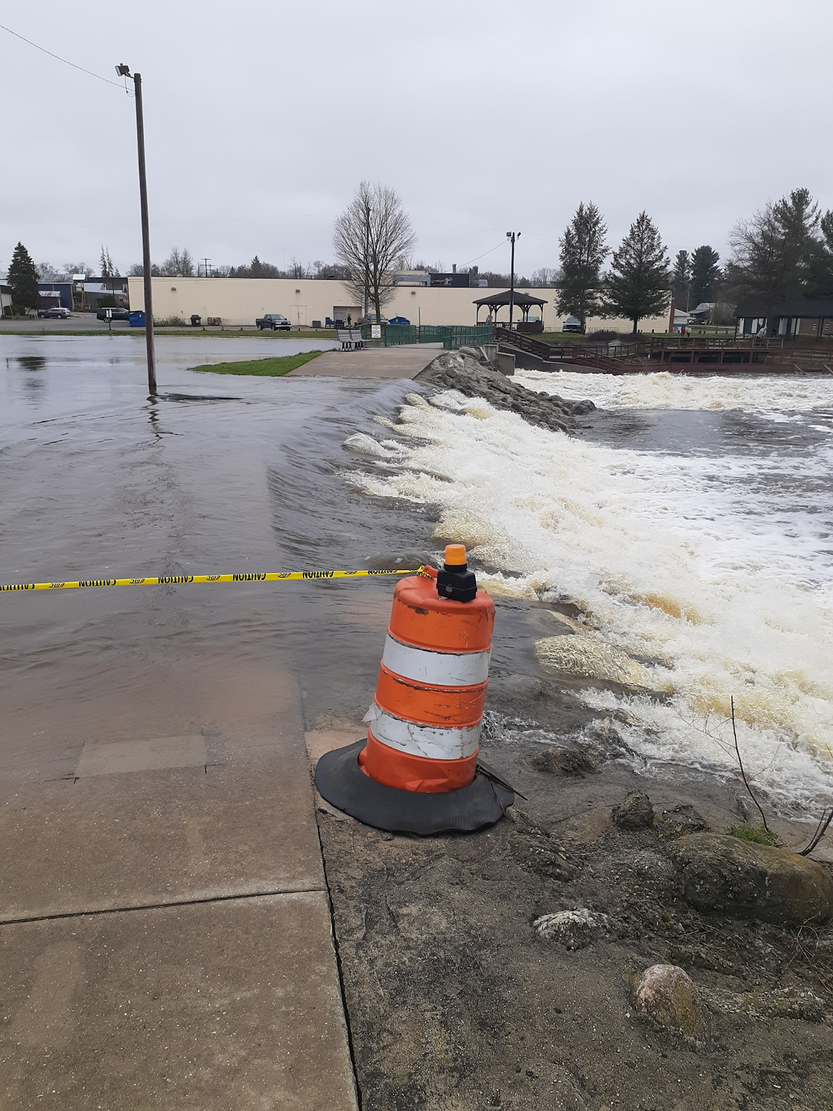
White River Basin: With the bulk of the White River drainage basin getting the heavy rain, a significant rise in the river occurred over the next few days. The river briefly exceeded flood stage, resulting in floodwaters approaching several homes. Auxiliary spillways were also used on several of the dams on the White River.
 |
|
The official measurement station on the White River near Whitehall briefly rose above flood levels. |
 |
|
Spillway in use at the Hesperia Dam on the White River. Photo courtesy NWS Spotter on Social Media |
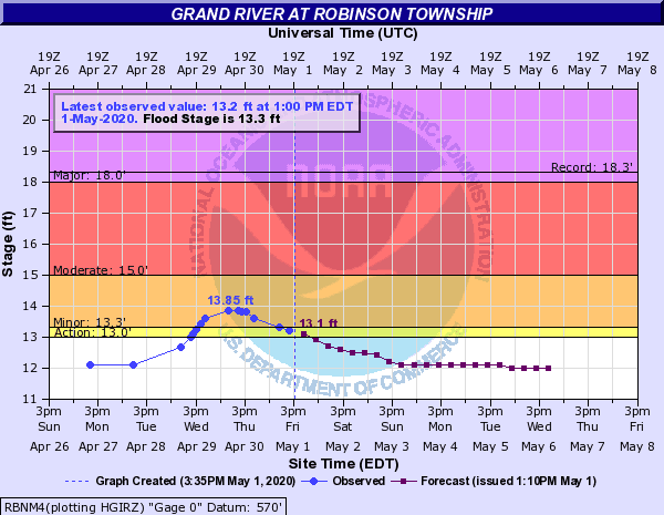
Grand River Basin: While all of the Grand River basin received rain, only the lower portions (those closest to Lake Michigan) saw the most significant rainfall amounts. Several of the smaller tributary rivers that flow into the Grand River in these areas rose to near flood stage in the following days. With all of the smaller streams running full, the Grand River rose quickly from downtown Grand Rapids all the way down to the rivermouth in Grand Haven. Compounding the water rise around Grand Haven was the extra water being pushed up the river from the unusually high Lake Michigan levels, which made flooding worse in places like Spring Lake and Robinson Township. See the Lakeshore Flooding tab for more information.
 |
|
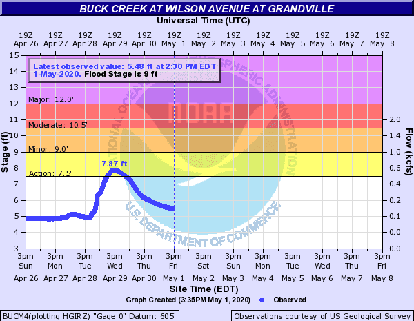
Smaller rivers flowing into the Grand River, such as Buck Creek and Plaster Creek, saw huge rises in water levels, but avoided significant flooding. |
 |
|
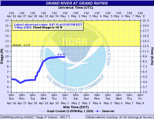
While the Grand River at Grand Rapids stayed safely below flood levels, a 4-5 ft rise in just over 24 hours is very unusual and impressive at this location. |
 |
|
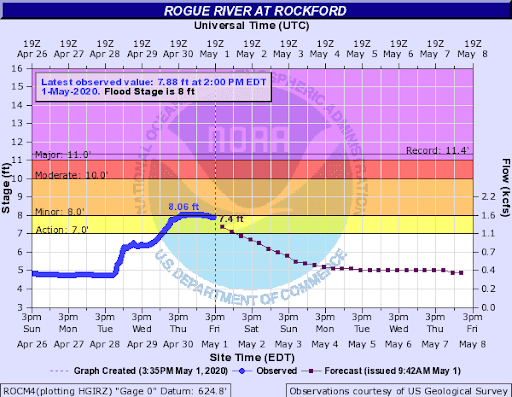
The official measurement on the Rogue River near Rockford crested around flood stage. This briefly resulted in a few road closures, but avoided any significant impacts. |
 |
|
The combination of greatly increased amounts of water coming down the river combined with more water pushing backwards up the river from Lake Michigan to cause a significant and abrupt rise in portions of the river near Robinson Township and Spring Lake/Grand Haven. See the Lakeshore Flooding section of this event summary for more information. |
Lakeshore Flooding:
A lakeshore flood event began on the evening of Tuesday April 28th, peaked on Wednesday April 29th and finally subsided on Thursday April 30th. Lake Michigan levels have been gradually climbing since 2013, and a strong wind event over the Great Lakes between the 28th and 30th exacerbated the problem. Lakes Michigan and Huron are connected at the Straits of Mackinac and because they share water back and forth they usually have the same water levels, and are considered to be the same lake for official water level purposes. On April 28, strong easterly winds blowing through the Straits for roughly 24 hours pushed a significant amount of water from Lake Huron into Lake Michigan. Wind speeds on Mackinac Island gusted over 20 mph for 36 straight hours. Winds exceeded 35 mph at times and were sustained over 20 mph for roughly 8 hours. Water levels rose across all of Lake Michigan, with flooding noted in Green Bay, Wisconsin, Northwest Indiana and in many port towns across Western Lower Michigan. Northerly winds ramped up on the 29th as the low pressure system moved across Southern Lake Michigan and into Western Lower Michigan. The northerly push of winds, which were even stronger (a 58 mph gust was recorded at Green Bay Wisconsin on the afternoon of the 29th) helped surge water down the length of the lake. As the levels of Lake Michigan rose to heights that were above those in the river mouths, the water surged back into port towns through the piers. The lakeshore flooding event was a combination of already high water levels, the winds and the push of water through the Straits. Water moving through the Straits is caused by wind and is often very fast, moving about 80,000 cubic meters of water (more than the volume of 32 Olympic swimming pools) per second! This created a flow of water with speeds more than 1 meter per second, which means that if you were swimming underneath the Mackinac Bridge during this time, only the strongest swimmers would be able to overcome the flow of water from Lake Huron back into Lake Michigan. More information can be found here… Straits Explanation
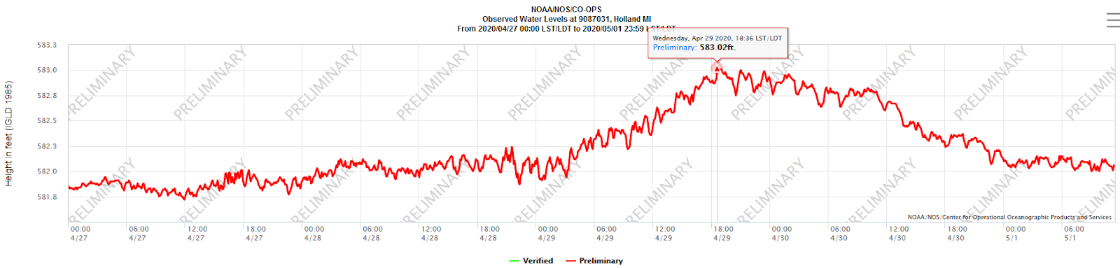
Holland MI water levels measured at base of north pier (adjacent to Holland State Park) April 27th - May 1st, 2020
Water levels at Holland Michigan peaked at 583.02 feet which is second all time (only 1.8 inches off the all time record). Water levels at Holland Michigan have been measured since the summer of 1894. We are beginning to change out the record list once dominated by the mid 1980’s to the current high water time we are now in the midst of.
Top 5 All Time High Water Levels at Holland, Michigan
| Date | Lake Level in Feet |
| December 1, 1985 | 583.17 |
| April 29, 2020 | 583.02 |
| November 27, 2019 | 582.92 |
| December 1, 2019 | 582.80 |
| October 3, 1986 | 582.70 |
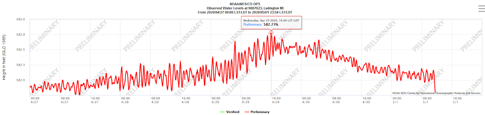
Ludington MI water levels measured on Pere Marquette Lake adjacent to Lake Street April 27th - May 1st, 2020
Water levels at Ludington Michigan peaked at 582.77 feet which is fifth all time (only 1.08 inches off the all time record). Water levels at Ludington Michigan have been measured since the fall of 1895. We are beginning to change out the record list once dominated by the mid 1980’s to the current high water time we are now in the midst of.
Top 5 All Time High Water Levels at Ludington, Michigan
| Date | Lake Level in Feet |
| July 20, 2019 | 582.86 |
| December 1, 2019 | 582.85 |
| October 14, 1986 | 582.84 |
| September 27, 1986 | 582.80 |
| April 29, 2020 | 582.77 |

To illustrate the rise on Lake Michigan and the corresponding fall on Lake Huron, here are water levels recorded at Calumet Harbor, IL (near Chicago) and Harbor Beach, MI (located in Michigan’s Thumb) Calumet Harbor crested at 583.43 feet, while Harbor Beach bottomed out at 581.22 feet. A lake elevation difference of 2.21 feet between Lake Michigan and Lake Huron. The rise and fall of the two lakes can clearly be seen in this image from the FVCOM water level model which is in the process of being developed for and implemented across all of the Great Lakes.
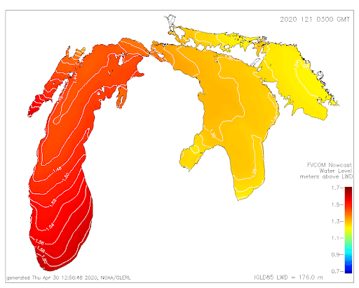
This image is valid at 1100pm on the evening of April 29th, 2020. Red colors show higher lake levels, while the yellow color indicates lower lake levels.
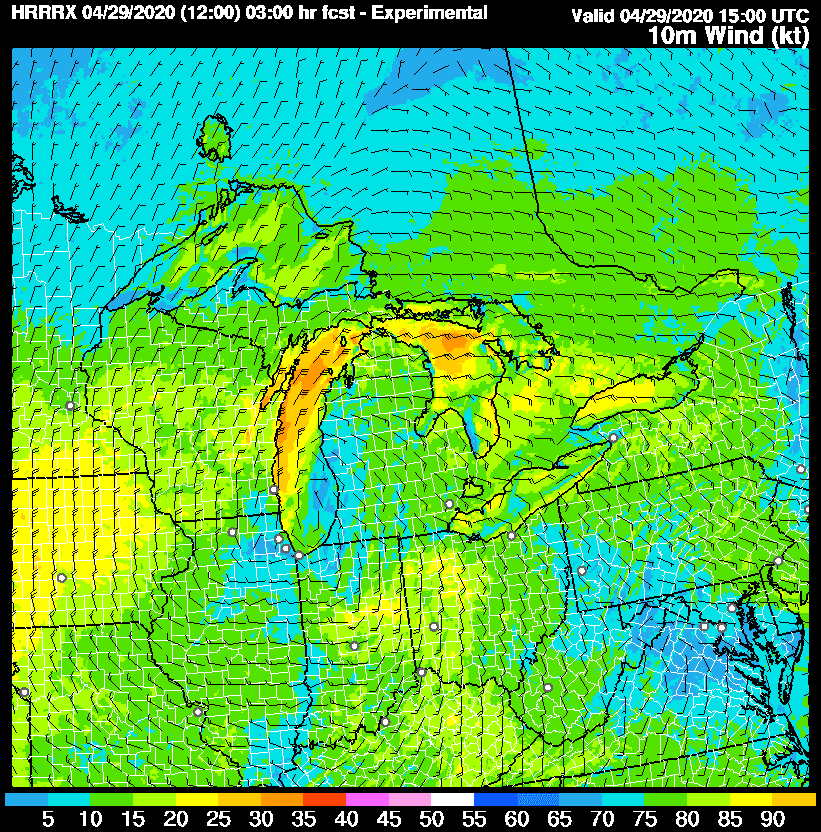
1100am Forecast Winds from a high resolution model (HRRRX)
Strong winds can be seen in this image in the yellow and orange colors over Northern Lake Huron and much of Northern and Central Lake Michigan. Envision water pushing through the Straits on the easterly winds and down Lake Michigan on the northerly winds.
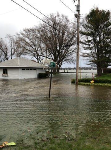
Flooding Wednesday April 29th, 2020 in Holland, MI
Photo Courtesy of Ottawa County Emergency Services
Water surged through the pier heads into Lake Macatawa and into adjacent neighborhoods on the north side of the lake.
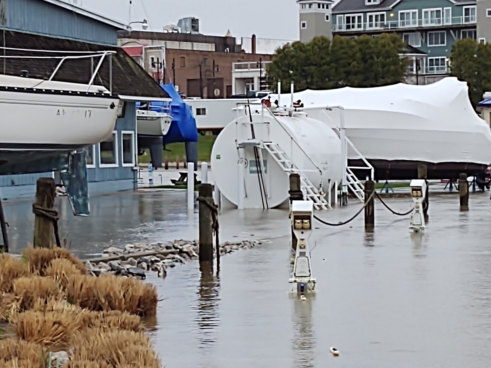
Flooding of a marina in downtown South Haven, April 29th, 2020
Photo Courtesy of South Haven Area Emergency Services
Water surged through the pier heads and into the Black River, flooding roads, marinas and buildings adjacent to the river.
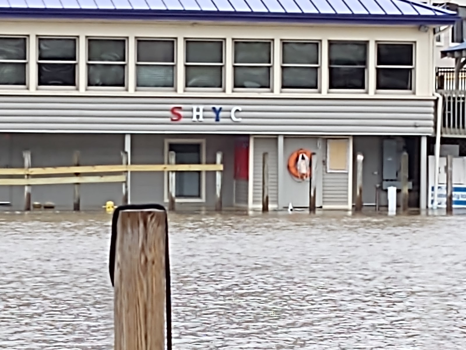
Flooding of the South Haven Yacht Club, April 29th, 2020
Photo Courtesy of South Haven Area Emergency Services
Water surged through the pier heads and into the Black River, flooding roads, marinas and buildings adjacent to the river.
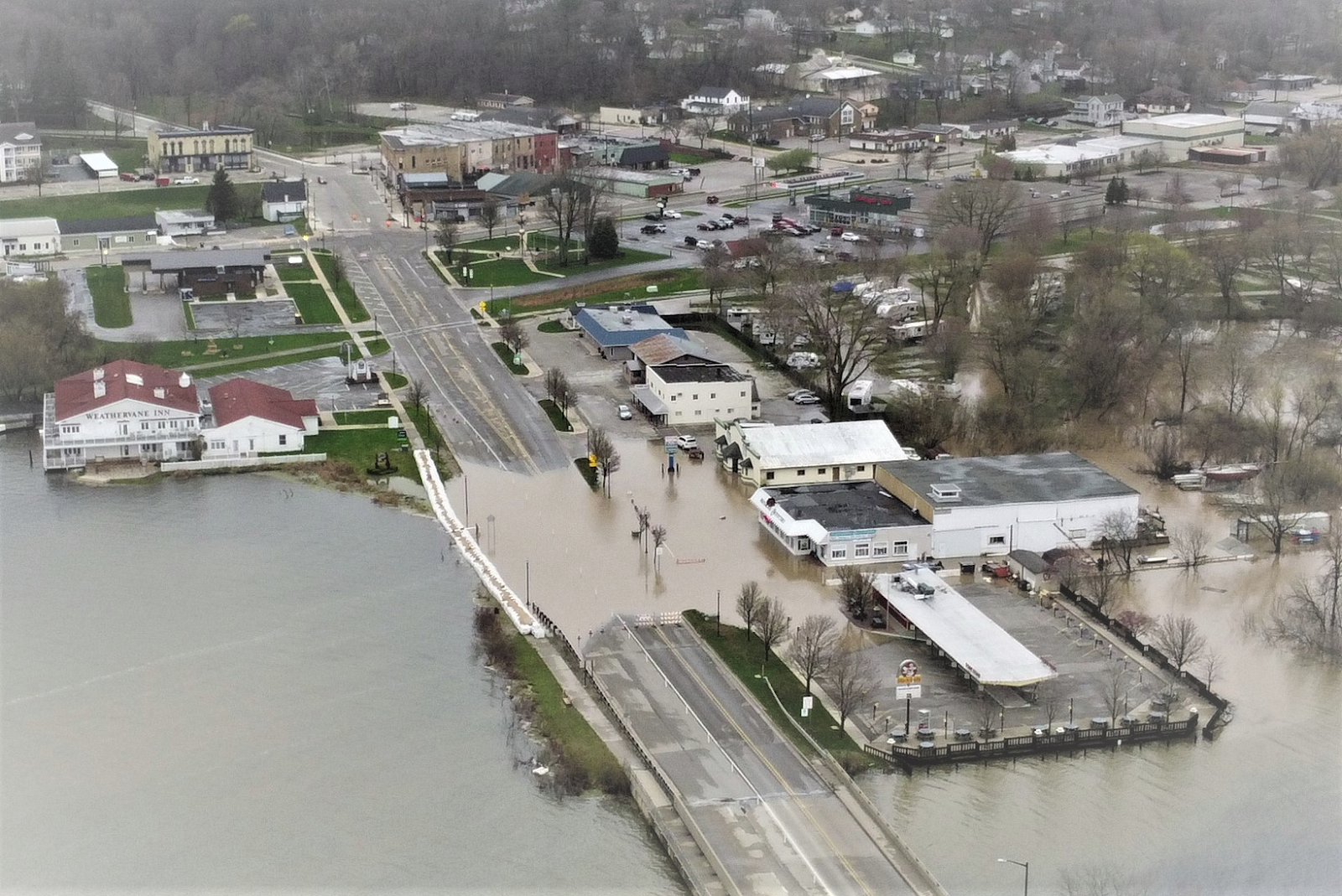
Flooding of Business 31 in Pentwater, MI, April 29th, 2020
Photo Courtesy of Pentwater Police
Water surged through the pier heads and into Pentwater Lake, flooding roads, marinas and buildings adjacent to the river.
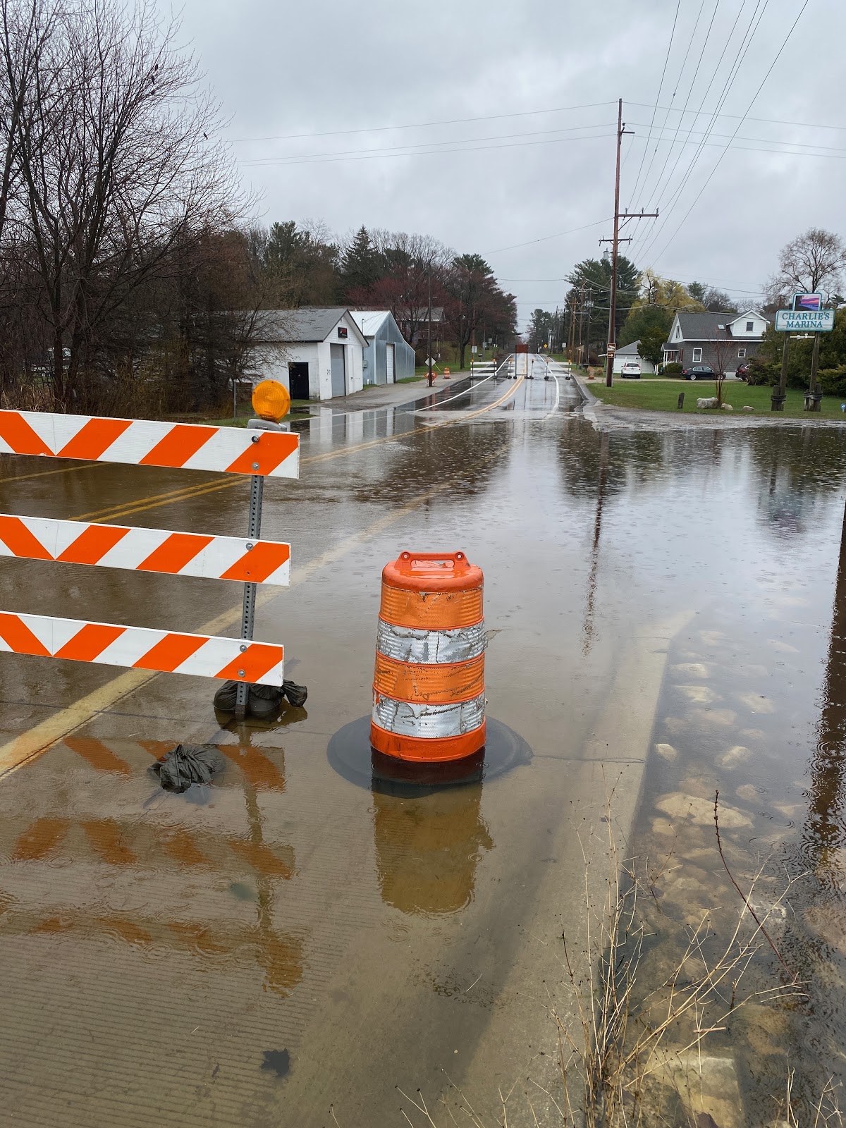
Flooding of Dowling St. in Montague, MI, April 29th, 2020
Photo Courtesy of Jim Campbell Aerial Photography Services via FOX17
Water surged through the pier heads and into White Lake, flooding roads, marinas and buildings adjacent to the river/lake.
This location is roughly 5 miles inland from the pier heads.
Rainfall Reports
...48 Hour Precipitation Reports from Tuesday Evening Through Thursday Morning...
| Location | Amount (inches) | Time of Report | Latitude/Longitude |
| 2 WNW Spring Lake | 4.80 | 0700 AM 04/30 | 43.08N/86.22W |
| Norton Shores 2.3 SSE | 4.55 | 1033 AM 04/30 | 43.13N/86.24W |
| 1 NE Norton Shores | 3.81 | 0800 AM 04/30 | 43.17N/86.24W |
| Muskegon 3.5 SSE | 3.72 | 0650 AM 04/30 | 43.18N/86.24W |
| Grant 4.8 NW | 3.55 | 0700 AM 04/30 | 43.38N/85.88W |
| Spring Lake 1.4 NNW | 3.46 | 0800 AM 04/30 | 43.09N/86.20W |
| North Muskegon 2.4 NW | 3.41 | 0825 AM 04/30 | 43.28N/86.30W |
| North Muskegon 1.9 NE | 3.22 | 0840 AM 04/30 | 43.27N/86.25W |
| Allendale 1.7 SE | 3.04 | 0700 AM 04/30 | 42.97N/85.93W |
| Belmont 1.0 WNW | 2.64 | 0800 AM 04/30 | 43.08N/85.63W |
| 2 WNW Belmont | 2.62 | 0700 AM 04/30 | 43.09N/85.64W |
| Holland 4.3 NNW | 2.61 | 0700 AM 04/30 | 42.82N/86.15W |
| Grand Rapids 2.9 NW | 2.49 | 0800 AM 04/30 | 42.99N/85.69W |
| Montague 8.1 NW | 2.49 | 0700 AM 04/30 | 43.50N/86.47W |
| White Cloud 7.5 ENE | 2.41 | 0700 AM 04/30 | 43.61N/85.64W |
| Lowell 5.5 N | 2.36 | 0700 AM 04/30 | 43.01N/85.35W |
| East Grand Rapids 1.2 WNW | 2.23 | 0730 AM 04/30 | 42.96N/85.63W |
| Big Rapids 5.4 S | 2.12 | 0700 AM 04/30 | 43.63N/85.48W |
| 2 SSW Cascade | 2.07 | 0800 AM 04/30 | 42.88N/85.52W |
| Grand Junction 1.4 NW | 2.06 | 0700 AM 04/30 | 42.42N/86.08W |
| Cedar Springs 2.8 SSW | 2.05 | 0700 AM 04/30 | 43.18N/85.57W |
| Harrison 5.2 ESE | 2.03 | 0700 AM 04/30 | 43.99N/84.70W |
| Trufant 1.8 SE | 2.00 | 0800 AM 04/30 | 43.29N/85.33W |
| 2 S Holland | 1.92 | 0800 AM 04/30 | 42.75N/86.10W |
| 3 S Grandville | 1.87 | 0900 AM 04/30 | 42.86N/85.75W |
| 4 SSE Shepherd | 1.83 | 0700 AM 04/30 | 43.47N/84.67W |
| Lakeview 2.5 NNE | 1.78 | 0800 AM 04/30 | 43.48N/85.26W |
| Hopkins 1 N | 1.71 | 0700 AM 04/30 | 42.64N/85.76W |
| Fenwick 3.3 E | 1.66 | 0700 AM 04/30 | 43.15N/85.01W |
| Wayland 2.0 W | 1.65 | 0700 AM 04/30 | 42.67N/85.68W |
| Hart 3 WSW | 1.54 | 0700 AM 04/30 | 43.67N/86.42W |
Observations are collected from a variety of sources with varying equipment and exposures. We thank all volunteer weather observers for their dedication. Not all data listed are considered official.
 |
Thank you to everyone who gave us permission to use their photos! Media use of NWS Web News Stories is encouraged! |
|
Page Last Updated: May 5th, 2020

