Dangerous heat will expand from the Gulf Coast into the Southern Plains and Desert Southwest through week's end. Additional extreme heat impacting the Pacific Northwest will shift to the northern Plains by the weekend. Tropical Storm Bertha is expected to continue to impact portions of the northern Gulf Coast from the western Florida Panhandle to southeastern Louisiana through tonight. Read More >
June 10, 2020 Severe Thunderstorms and Heavy Rain
 |
|
A large tree was blown down by winds in Sand Lake, MI. Roof damage was also done to the house. Photo courtesy of Pam Prins. |
Severe weather, mostly in the form of damaging winds, became widespread across Western and Central Lower Michigan during the late morning and afternoon of June 10, 2020. The storms left more than 300,000 people without power Statewide. In Western and Central Michigan, some of the hardest hit areas were in Ottawa, Calhoun, Clinton, and Gratiot Counties. A 73 mph wind gust was recorded in Holland and a 75 mph wind gust was recorded in Grandville. Numerous trees were reported down in Grandville near Rivertown Crossings, and 2 semi-trucks were overturned by strong winds on U.S. 127 in Gratiot County.
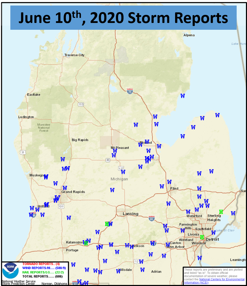
SPC Unfiltered Reports for June 10th, 2020
Severe Weather Reports
..TIME...   ...EVENT...      ...CITY LOCATION...     ...LAT.LON...
..DATE...   ....MAG....      ..COUNTY LOCATION..ST.. ...SOURCE....
            ..REMARKS..

0900 AM     HEAVY RAIN       WHITE CLOUD             43.55N 85.78W
06/10/2020  M1.02 INCH       NEWAYGO            MI   EMERGENCY MNGR

            24 HOUR TOTAL.

1120 AM     TSTM WND GST     3 W SOUTH HAVEN         42.40N 86.33W
06/10/2020  M45 MPH          LMZ844             MI   BUOY

            BUOY 45168 2 W SOUTH HAVEN.

1120 AM     NON-TSTM WND GST 3 W SOUTH HAVEN         42.40N 86.33W
06/10/2020  M45 MPH          LMZ844             MI   MESONET

            MESONET STATION 45168 2 W SOUTH HAVEN.

1131 AM     TSTM WND GST     2 NNW SAUGATUCK         42.68N 86.22W
06/10/2020  M62 MPH          LMZ845             MI   MESONET

            MESONET STATION XSTK SAUGATUCK PIER.

1140 AM     TSTM WND DMG     HAMILTON                42.68N 86.01W
06/10/2020                   ALLEGAN            MI   PUBLIC

            ROOF TILES BLOWN OFF HOME. MANY LARGE
            BRANCHES DOWN. TIME ESTIMATED FROM RADAR.

1142 AM     TSTM WND GST     MACATAWA                42.77N 86.20W
06/10/2020  M61 MPH          OTTAWA             MI   BUOY

            BUOY STATION HLNM4 HOLLAND HARBOR.

1145 AM     TSTM WND DMG     2 N DRENTHE             42.81N 85.94W
06/10/2020                   OTTAWA             MI   PUBLIC

            BARN ROOF DAMAGE, POWER POLE DOWN, TREES
            DOWN NEAR VRIESLAND. TIME ESTIMATED FROM
            RADAR.

1145 AM     TSTM WND GST     2 S HOLLAND             42.75N 86.10W
06/10/2020  M73 MPH          ALLEGAN            MI   ASOS


1149 AM     TSTM WND GST     3 NNE DRENTHE           42.82N 85.93W
06/10/2020  M59 MPH          OTTAWA             MI   MESONET

            MEASURED GUST AT OTTAWA EXECUTIVE AIRPORT.

1150 AM     TSTM WND DMG     2 N DRENTHE             42.81N 85.94W
06/10/2020                   OTTAWA             MI   TRAINED SPOTTER

            DAMAGE TO A WELL-CONSTRUCTED BARN IN
            VRIESLAND.

1152 AM     TSTM WND DMG     3 NE ZEELAND            42.84N 85.96W
06/10/2020                   OTTAWA             MI   PUBLIC

            CHICKEN COOP BLOWN OVER. TIME ESTIMATED.

1155 AM     TSTM WND DMG     HOLLAND                 42.78N 86.10W
06/10/2020                   OTTAWA             MI   EMERGENCY MNGR

            EMERGENCY MANAGEMENT REPORTS A SEMI TRUCK
            FLIPPED OVER. STREET LIGHTS ARE KNOCKED
            DOWN. THERE ARE SOME TREES ON HOMES.

1159 AM     TSTM WND GST     2 SE BAUER              42.91N 85.88W
06/10/2020  M51 MPH          OTTAWA             MI   MESONET

            STATION MIHUDSO46.

1203 PM     TSTM WND DMG     2 SSW GRANDVILLE        42.87N 85.77W
06/10/2020                   KENT               MI   PUBLIC

            LARGE HEALTHY TREE SNAPPED. TIME ESTIMATED
            FROM RADAR.

1205 PM     TSTM WND DMG     1 SSE GRANDVILLE        42.88N 85.74W
06/10/2020                   KENT               MI   PUBLIC

            ROOF DAMAGE, NUMEROUS DOWNED TREES NEAR
            IVANREST AND 44TH STREET. GUST MEASURED FROM
            HOME WEATHER STATION OF 75 MPH.

1208 PM     TSTM WND DMG     2 SSE BELMONT           43.04N 85.60W
06/10/2020                   KENT               MI   PUBLIC

            LARGE TREE DOWN AT 5 MILE AND BONANZA. TIME
            ESTIMATED.

1210 PM     TSTM WND GST     1 SE GRANDVILLE         42.90N 85.74W
06/10/2020  M75 MPH          KENT               MI   MESONET

            MESONET STATION DW6683 GRANDVILLE.

1212 PM     TSTM WND GST     1 NW CUTLERVILLE        42.85N 85.68W
06/10/2020  M58 MPH          KENT               MI   TRAINED SPOTTER

            MEASURED GUST IN GAINES TWP.

1212 PM     TSTM WND GST     2 NNE WYOMING           42.92N 85.69W
06/10/2020  M60 MPH          KENT               MI   PUBLIC

            MEASURED GUST.

1215 PM     TSTM WND DMG     1 N CUTLERVILLE         42.85N 85.66W
06/10/2020                   KENT               MI   PUBLIC

            TREE FELL ON A HOUSE.

1215 PM     TSTM WND DMG     1 SW RAVENNA            43.18N 85.95W
06/10/2020                   MUSKEGON           MI   TRAINED SPOTTER

            17 INCH DIAMETER TREES UPROOTED. HEALTHY
            TREES KNOCKED OVER. VEHICLE DAMAGED.

1215 PM     TSTM WND GST     2 ESE WRIGHT            43.10N 85.77W
06/10/2020  M65 MPH          KENT               MI   TRAINED SPOTTER

            MEASURED NEAR FRUIT RIDGE AND 9 MILE RD.

1216 PM     TSTM WND GST     EAST GRAND RAPIDS       42.95N 85.61W
06/10/2020  M54 MPH          KENT               MI   TRAINED SPOTTER

            MEASURED AT MEMORIAL FIELD.

1216 PM     TSTM WND DMG     FOWLER                  43.01N 84.74W
06/10/2020                   CLINTON            MI   PUBLIC

            SIGNIFICANT DAMAGE TO TREES. POWER OUT. TIME
            ESTIMATED FROM RADAR.

1219 PM     TSTM WND DMG     6 N ORANGEVILLE         42.64N 85.53W
06/10/2020                   BARRY              MI   PUBLIC

            REPORT FROM MPING: 3-INCH TREE LIMBS BROKEN;
            POWER POLES BROKEN.

1220 PM     HAIL             2 W SAND LAKE           43.30N 85.55W
06/10/2020  M0.75 INCH       MONTCALM           MI   PUBLIC

            REPORT FROM MPING: DIME (0.75 IN.).

1227 PM     TSTM WND DMG     5 W SAND LAKE           43.29N 85.62W
06/10/2020                   KENT               MI   EMERGENCY MNGR

            TREES DOWN ON BARN. A TREE ALSO FELL ON A
            GARBAGE TRUCK.

1245 PM     TSTM WND GST     5 SSE MAPLE RAPIDS      43.05N 84.65W
06/10/2020  M55 MPH          CLINTON            MI   MESONET

            MESONET STJOH10.

1250 PM     TSTM WND DMG     4 WNW ASHLEY            43.20N 84.56W
06/10/2020                   GRATIOT            MI   BROADCAST MEDIA

            SEMI TRUCK BLOWN OVER ON US 127 NEAR M-57.
            TIME ESTIMATED.

0117 PM     TSTM WND DMG     SHEPHERD                43.53N 84.69W
06/10/2020                   ISABELLA           MI   PUBLIC

            LARGE TREE DOWN IN RESIDENTIAL NEIGHBORHOOD.
            TIME ESTIMATED FROM RADAR.

0120 PM     TSTM WND GST     4 N PERRINTON           43.23N 84.69W
06/10/2020  M41 MPH          GRATIOT            MI   MESONET

            STATION MIITHAC4.

0120 PM     TSTM WND GST     4 S SHEPHERD            43.47N 84.71W
06/10/2020  M66 MPH          ISABELLA           MI   MESONET

            MEASURED GUST AT STATION MISHEPH5.

0159 PM     TSTM WND GST     1 SSW SPRINGFIELD       42.31N 85.24W
06/10/2020  M59 MPH          CALHOUN            MI   ASOS

            MEASURED AT BATTLE CREEK EXECUTIVE AIRPORT.

0207 PM     HAIL             2 SE SPRINGFIELD        42.30N 85.22W
06/10/2020  M1.00 INCH       CALHOUN            MI   PUBLIC

            REPORT FROM MPING: QUARTER (1.00 IN.).

0208 PM     TSTM WND DMG     1 NNE BATTLE CREEK      42.33N 85.17W
06/10/2020                   CALHOUN            MI   PUBLIC

            SEVERAL TREES DOWN IN RESIDENTIAL
            NEIGHBORHOOD. TIME ESTIMATED FROM RADAR.

0215 PM     HEAVY RAIN       1 S HASTINGS            42.64N 85.29W
06/10/2020  M1.58 INCH       BARRY              MI   CO-OP OBSERVER

            RAINFALL SINCE 7AM.

0220 PM     TSTM WND DMG     BELLEVUE                42.45N 85.02W
06/10/2020                   EATON              MI   PUBLIC

            NUMEROUS TREES AND WIRES DOWN. TIME IS AN
            ESTIMATE.

0230 PM     HAIL             CHARLOTTE               42.56N 84.84W
06/10/2020  M1.00 INCH       EATON              MI   PUBLIC


0230 PM     TSTM WND DMG     3 E CHARLOTTE           42.56N 84.77W
06/10/2020                   EATON              MI   TRAINED SPOTTER

            MANY TREES DOWN ALONG OR NEAR STEWART RD.
            SOME TREES ARE HEALTHY AND AROUND 1 FT IN
            DIAMETER. IN GENERAL, MANY TREES ARE
            OBSERVED TO HAVE DAMAGE NOT FAR FROM THE
            FITCH BEACH AIRPORT.

0232 PM     TSTM WND GST     2 ESE CHARLOTTE         42.55N 84.79W
06/10/2020  M53 MPH          EATON              MI   PUBLIC

            MESONET MICHARL40.


0232 PM     TSTM WND DMG     2 W SAND LAKE           43.30N 85.55W
06/10/2020                   MONTCALM           MI   PUBLIC

            REPORT FROM MPING: TREES UPROOTED OR
            SNAPPED; ROOF BLOWN OFF.

0242 PM     TSTM WND DMG     2 SW MARSHALL           42.24N 84.99W
06/10/2020                   CALHOUN            MI   TRAINED SPOTTER

            TREE DAMAGE ON I-69 SOUTH OF MARSHALL.

0245 PM     TSTM WND DMG     2 N ALBION              42.28N 84.76W
06/10/2020                   CALHOUN            MI   TRAINED SPOTTER

            CORRECTS TIME OF PREVIOUS TSTM WND DMG
            REPORT FROM 2 N ALBION. OVER ONE FOOT
            DIAMETER OAK TREE DOWN ON WIRE, OVER THE
            ROAD ON D DRIVE N NEAR 28 MILE.

0255 PM     TSTM WND GST     1 SSE MARSHALL          42.25N 84.95W
06/10/2020  M60 MPH          CALHOUN            MI   ASOS

            MEASURED AT MARSHALL BROOKS FIELD ARPT.

0307 PM     TSTM WND GST     3 ENE SANDSTONE         42.27N 84.47W
06/10/2020  M62 MPH          JACKSON            MI   ASOS

            ASOS STATION KJXN JACKSON COUNTY-REYNOLDS
            FIELD AIRPORT.
0321 PM     TSTM WND DMG     1 E JACKSON             42.25N 84.39W
06/10/2020                   JACKSON            MI   PUBLIC

            1-INCH TREE LIMBS BROKEN; SHINGLES BLOWN
            OFF.
0459 PM     HEAVY RAIN       2 W WEBBERVILLE         42.66N 84.22W
06/10/2020  M0.59 INCH       INGHAM             MI   PUBLIC


0459 PM     HAIL             2 NE CEMENT CITY        42.09N 84.30W
06/10/2020  M0.50 INCH       JACKSON            MI   PUBLIC
0544 PM     HEAVY RAIN       1 W HOLT                42.64N 84.54W
06/10/2020  M1.52 INCH       INGHAM             MI   PUBLIC
Thank you to everyone who submitted damage reports, photos, and videos!
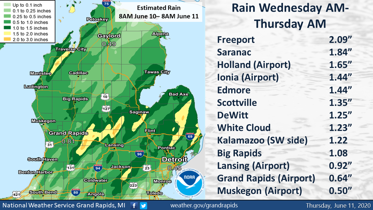
Heavy Rainfall
Thunderstorms dropped heavy rain in some locations as they tracked through Lower Michigan yesterday. The worst-hit areas experienced minor flooding of streets and in low-lying areas. As is typical when we see thunderstorms, rainfall can vary quite a bit from place to place. Rain totals in Kalamazoo for example ranged from 0.16” at the airport to 1.22 inches southwest of town.
 />
/>
Damage Pictures
|
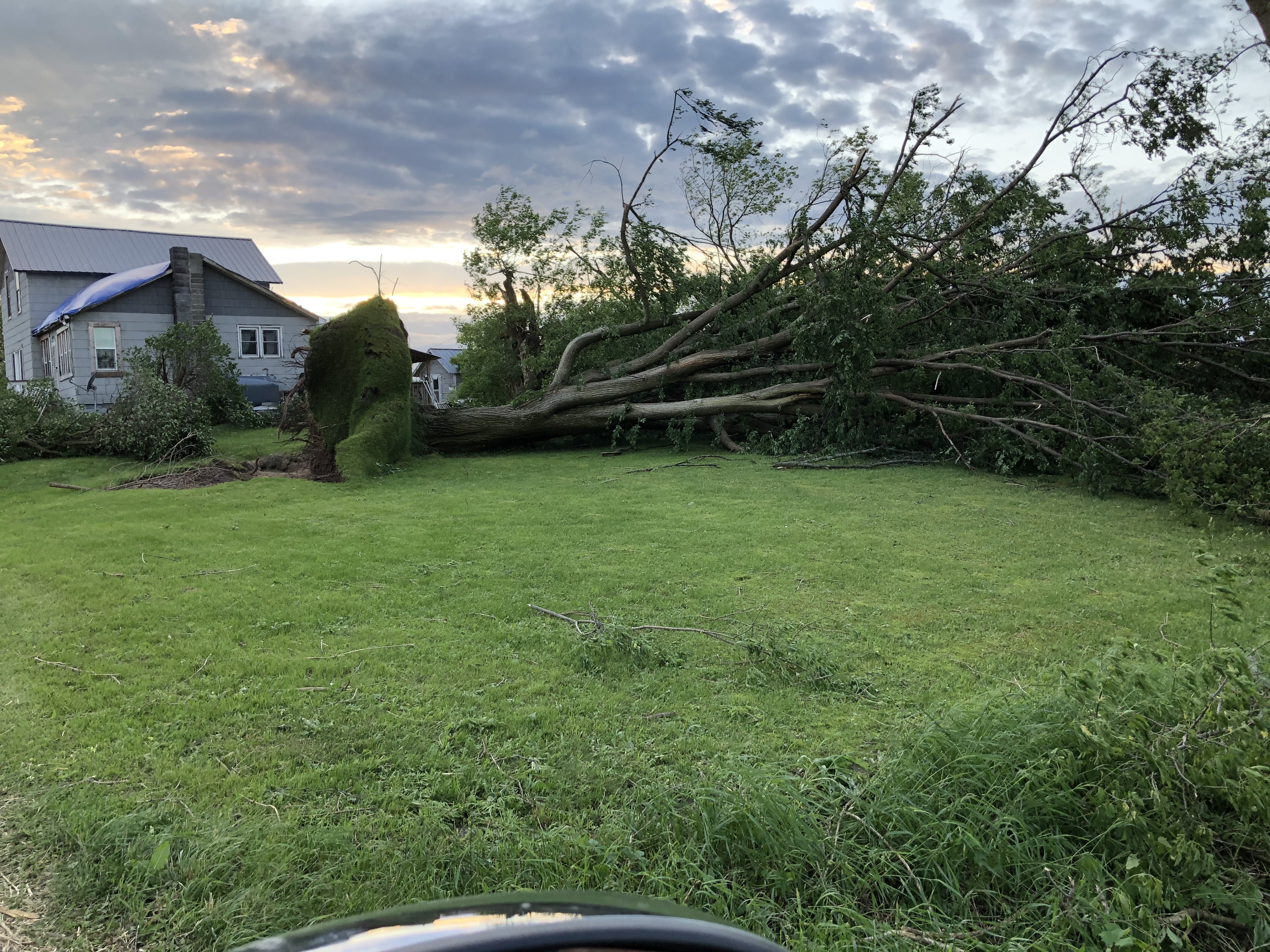
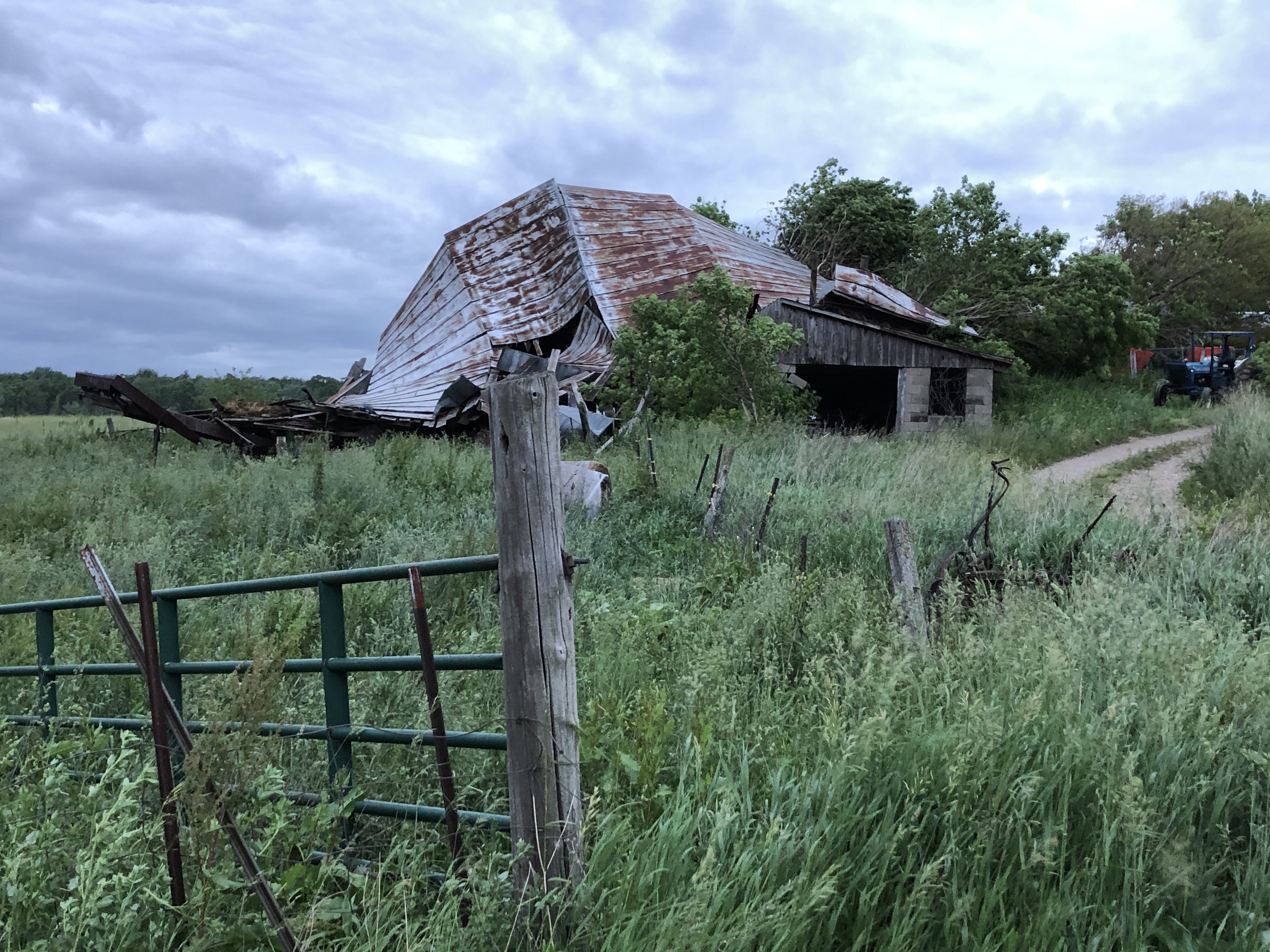
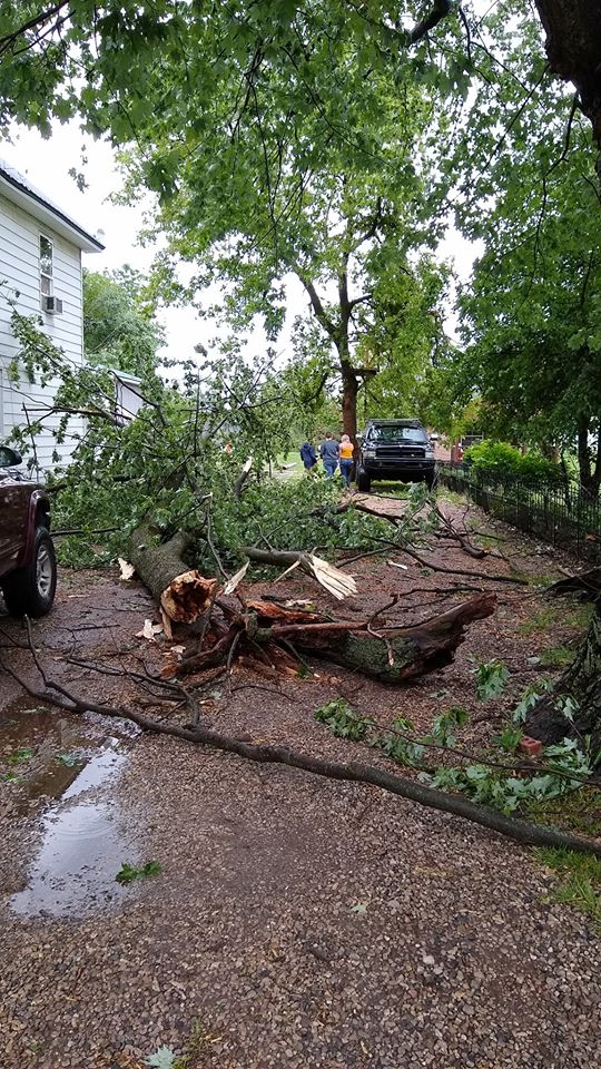
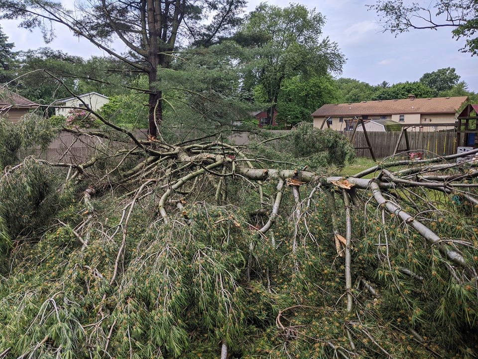
2 miles WNW of Sand Lake Photo courtesy of Pam Prins |
2 miles WNW of Sand Lake Photo courtesy of Pam Prins |
2 miles WNW of Sand Lake Photo courtesy of Pam Prins |
|
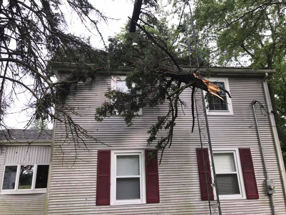
Emmett Township Photo courtesy of Brittany Lawson |
Grand Rapids Photo Courtesy of Mike Zapolnik |
Battle Creek Photo Courtesy of Andrew Matthews |
|
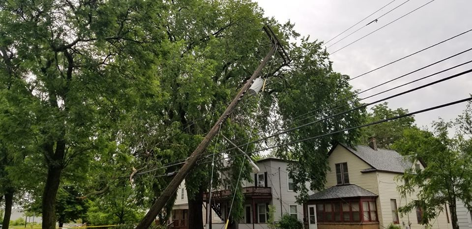
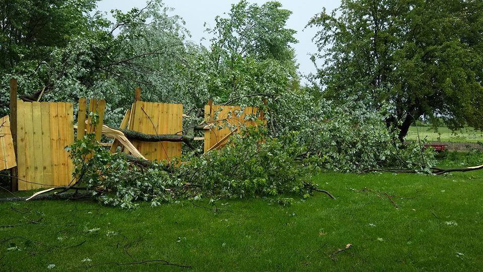
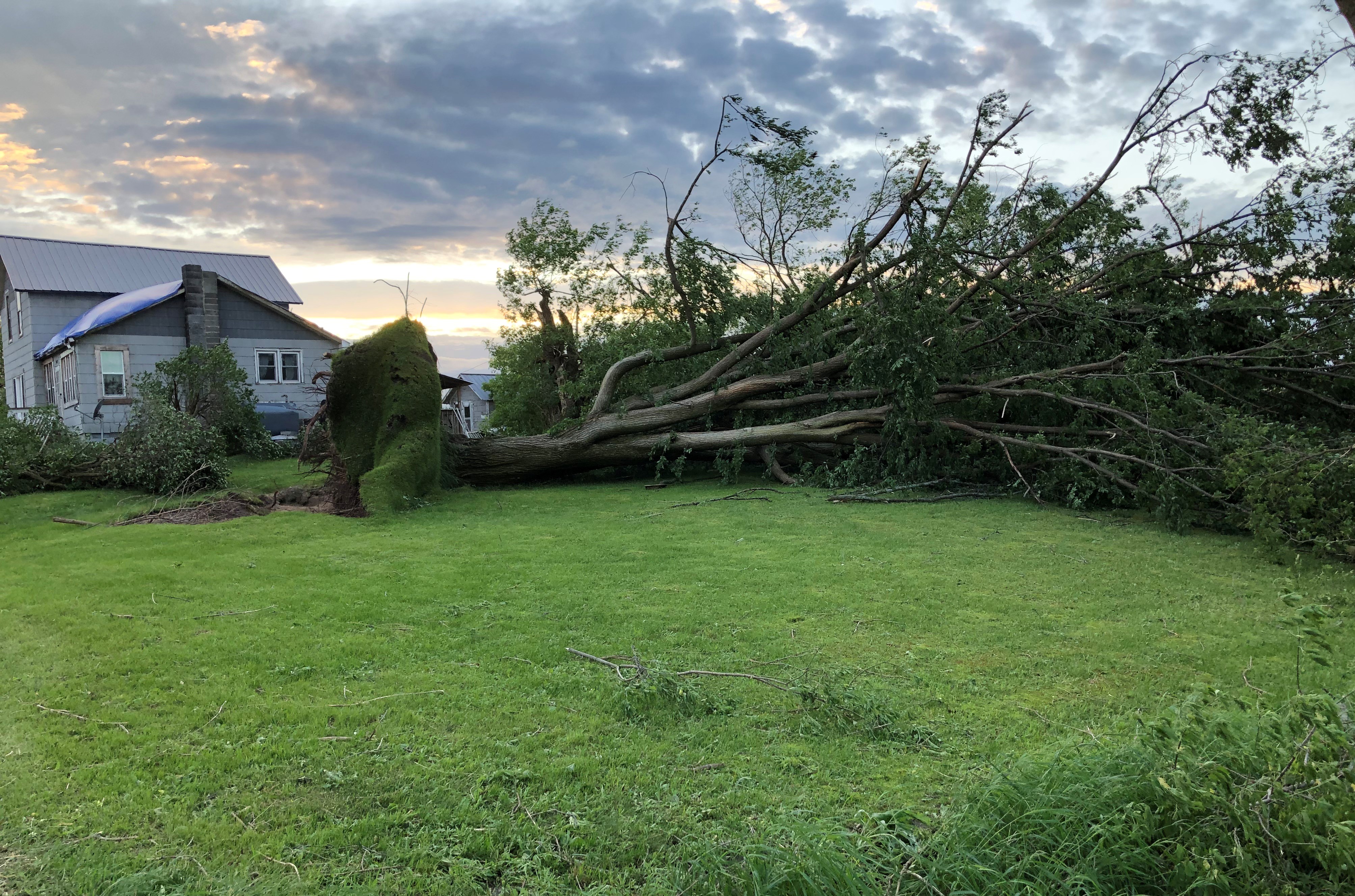
Ravenna Photo courtesy of Michael Graham |
North Star Photo courtesy of Michele Rich |
North Star Photo courtesy of Matthew Wolfe |
|
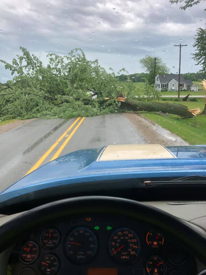
North Star Photo courtesy of Matthew Wolfe |
North Star Photo courtesy of Matthew Wolfe |
East Leroy Photo courtesy of Jenica Iciek |
|
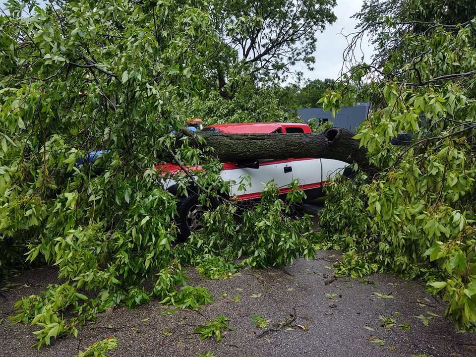
Wright Township Photo courtesy of Mike Parker |
Pierson Photo courtesy of Susan Maki George |
Walker Photo courtesy of Amy Nadeau |
|
Comstock Park Photo courtesy of Leisha England |
Holland Photo courtesy of Libby Piotrzkowski |
Albion Photo courtesy of Michael Evans |
Thank you to everyone who gave us permission to use their photos!
Radar
KGRR Reflectivity June 10th 2020 1104 am EDT to 135 pm EDT
KGRR Velocity Data June 10th 2020 1104 am EDT to 135 pm EDT
KGRR Reflectivity June 10th 2020 135 pm EDT to 400 pm EDT
KGRR Velocity June 10th 2020 135 pm EDT to 400 pm EDT
 |
Media use of NWS Web News Stories is encouraged! |
|
Page Last Updated: May 5th, 2020