
Widespread life-threatening flash and urban flooding continues in south-central Texas, with considerable flooding impacts possible across central Texas. Wildfire smoke is impacting air quality across much of the Great Lakes region into southern New England and the Mid-Atlantic. Monsoonal thunderstorms may produce isolated to scattered flash flooding across the Southwest into the Great Basin. Read More >
Overview
A major winter storm with blizzard conditions impacted much of Lower Michigan just before the Christmas holiday weekend 2022. Conditions deteriorated rapidly on Thursday afternoon with snow moving into the area. Around 6 PM on Thursday December the 23rd, wind at the Grand Rapids NWS office was calm. Then, the arctic cold front came through resulting in 20 mph and gusty winds from the west. The worst conditions at Grand Rapids were between 3 PM and 6 PM on Friday December 23rd. This is when the wind was strongest, and visibility was lowest in blowing and drifting snow. Accidents and multi-car pile ups led to closures of some Interstates and Highways on Friday.
Snow
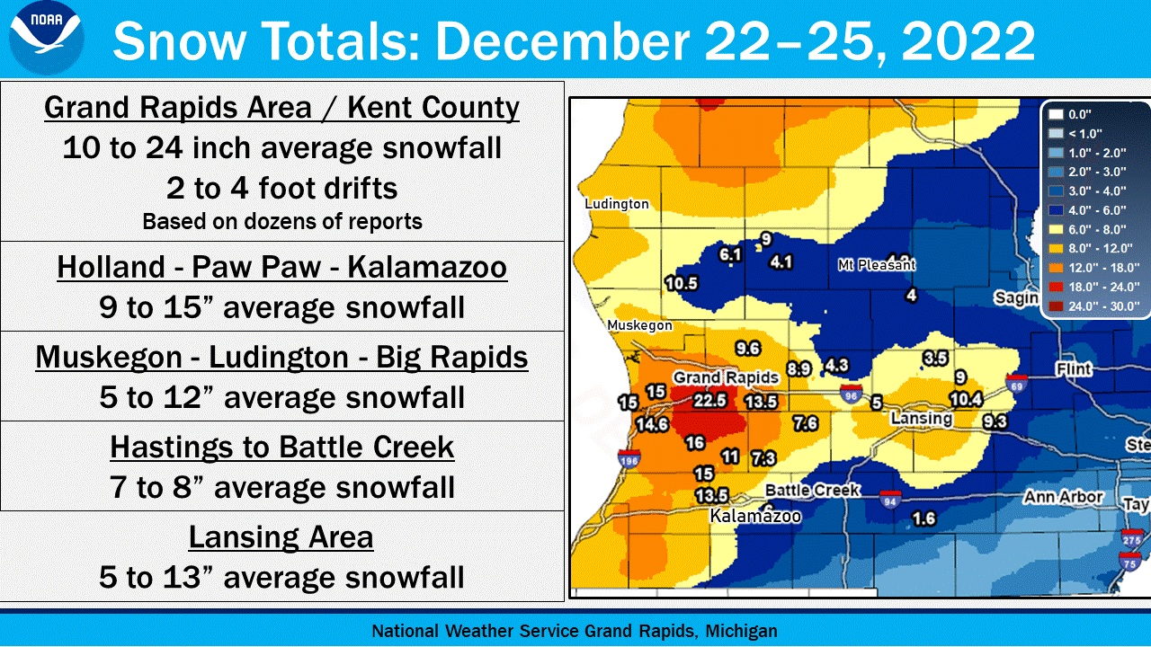
Drifting snow during blizzard conditions naturally makes it difficult to precisely measure newly fallen snow. Based on the many reports that have been sent in, it appears that the December 22 to 25 snow totals fell into roughly these ranges when averaged out, with some higher drifts. Frequent wind gusts of 35 to 45 mph (a few gusts to 55 mph) were recorded on December 23 with quarter mile visibility or less especially in West Michigan downwind of Lake Michigan, and temperatures were in the single digits to teens.
Wind
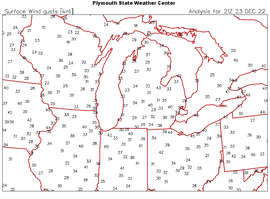
The strongest winds occurred in the afternoon and evening on Friday December 23. This is also when blowing and
drifting snow was at its worst. Peak wind speeds at various locations are listed below by County.


Location                     Speed     Time/Date       Lat/Lon

...Michigan...

...Allegan County...
W Mich Regional Arpt         47 MPH    0514 PM 12/23   42.75N/86.10W
Hopkins                      37 MPH    0139 PM 12/23   42.64N/85.68W
Plainwell                    35 MPH    1110 PM 12/22   42.66N/85.65W
Hopkins                      35 MPH    1007 AM 12/23   42.59N/85.70W

...Calhoun County...
Battle Creek Executive Airpo 53 MPH    0124 PM 12/23   42.32N/85.23W
Marshall Brooks Field        40 MPH    0235 PM 12/23   42.23N/84.95W

...Clinton County...
Lansing                      51 MPH    1238 PM 12/23   42.78N/84.58W

...Eaton County...
Charlotte Fitch Beach Arpt   39 MPH    0335 PM 12/23   42.57N/84.82W

...Gratiot County...
Alma                         43 MPH    0215 PM 12/23   43.32N/84.68W

...Ingham County...
1.8 S East Lansing (MAWN)    41 MPH    0300 PM 12/23   42.71N/84.48W
Mason Jewett Arpt            39 MPH    0635 AM 12/23   42.57N/84.42W
3.2 NE Holt (MAWN)           37 MPH    1200 PM 12/23   42.67N/84.49W

...Ionia County...
Ionia County Arpt            41 MPH    1235 PM 12/23   42.93N/85.07W
4.4 NW Smyrna (MAWN)         41 MPH    0200 PM 12/23   43.11N/85.31W
2.4 NW Clarksville (MAWN)    38 MPH    0600 PM 12/23   42.87N/85.26W

...Isabella County...
Shepherd                     41 MPH    0145 PM 12/23   43.47N/84.67W
Mt Pleasant Muni Arpt        40 MPH    0535 PM 12/23   43.62N/84.73W
Mount Pleasant               36 MPH    0610 PM 12/23   43.59N/84.77W
Mount Pleasant               35 MPH    0305 PM 12/23   43.58N/84.77W

...Jackson County...
Jackson County-Reynolds Fiel 45 MPH    0802 AM 12/23   42.27N/84.47W

...Kalamazoo County...
Kalamazoo/BC Intl Airport    43 MPH    1243 PM 12/23   42.23N/85.55W
Fulton                       35 MPH    0108 PM 12/23   42.12N/85.37W

...Kent County...
1 W Sand Lake                49 MPH    0120 PM 12/23   43.29N/85.54W
Gerald R Ford Intl           45 MPH    0422 PM 12/23   42.88N/85.52W
Cedar Springs                37 MPH    1227 PM 12/23   43.19N/85.51W
Cedar Springs                37 MPH    1238 PM 12/23   43.20N/85.59W
2.0 NW Sparta (MAWN)         35 MPH    0100 PM 12/23   43.18N/85.74W
3.2 NW Comstock Park (MAWN)  35 MPH    0700 PM 12/23   43.07N/85.72W

...Mason County...
Ludington Mason County Arpt  38 MPH    0515 PM 12/23   43.97N/86.40W
Ludington                    37 MPH    0642 PM 12/23   43.95N/86.44W

...Mecosta County...
1.8 N Sylvester (MAWN)       37 MPH    0300 PM 12/23   43.57N/85.24W
Big Rapids Roben-hood Arpt   36 MPH    1255 PM 12/23   43.72N/85.50W

...Montcalm County...
1.1 W Entrican (MAWN)        41 MPH    0100 PM 12/23   43.35N/85.18W

...Muskegon County...
Norton Shores                56 MPH    0455 PM 12/23   43.17N/86.26W
Muskegon County Airport      52 MPH    0637 PM 12/23   43.17N/86.23W
Muskegon Pier                51 MPH    0520 PM 12/23   43.23N/86.34W

...Oceana County...
Shelby                       52 MPH    0655 PM 12/23   43.62N/86.54W
Pentwater                    47 MPH    0615 PM 12/23   43.81N/86.38W
Pentwater                    42 MPH    0545 PM 12/23   43.78N/86.43W
2 NE Shelby                  36 MPH    0540 PM 12/23   43.64N/86.33W

...Osceola County...
Evart                        37 MPH    0413 PM 12/23   43.90N/85.25W

...Ottawa County...
Holland Harbor               48 MPH    1242 PM 12/23   42.77N/86.20W

...Van Buren County...
South Haven Rgnl Arpt        40 MPH    0615 PM 12/23   42.35N/86.25W
0.9 SE Lawton (MAWN)         39 MPH    0400 PM 12/23   42.16N/85.83W

...Maritime Stations...
Saugatuck Pier               62 MPH    0233 PM 12/23   42.68N/86.22W
Grand Haven Light            56 MPH    0839 AM 12/23   43.06N/86.26W
South Haven                  55 MPH    0900 AM 12/23   42.40N/86.29W
St. Joseph Pier              45 MPH    0635 AM 12/23   42.12N/86.49W

Observations are collected from a variety of sources with varying
equipment and exposures. We thank all volunteer weather observers
for their dedication. Not all data listed are considered official.
Photos & Video
 |
 |
 |
 |
|
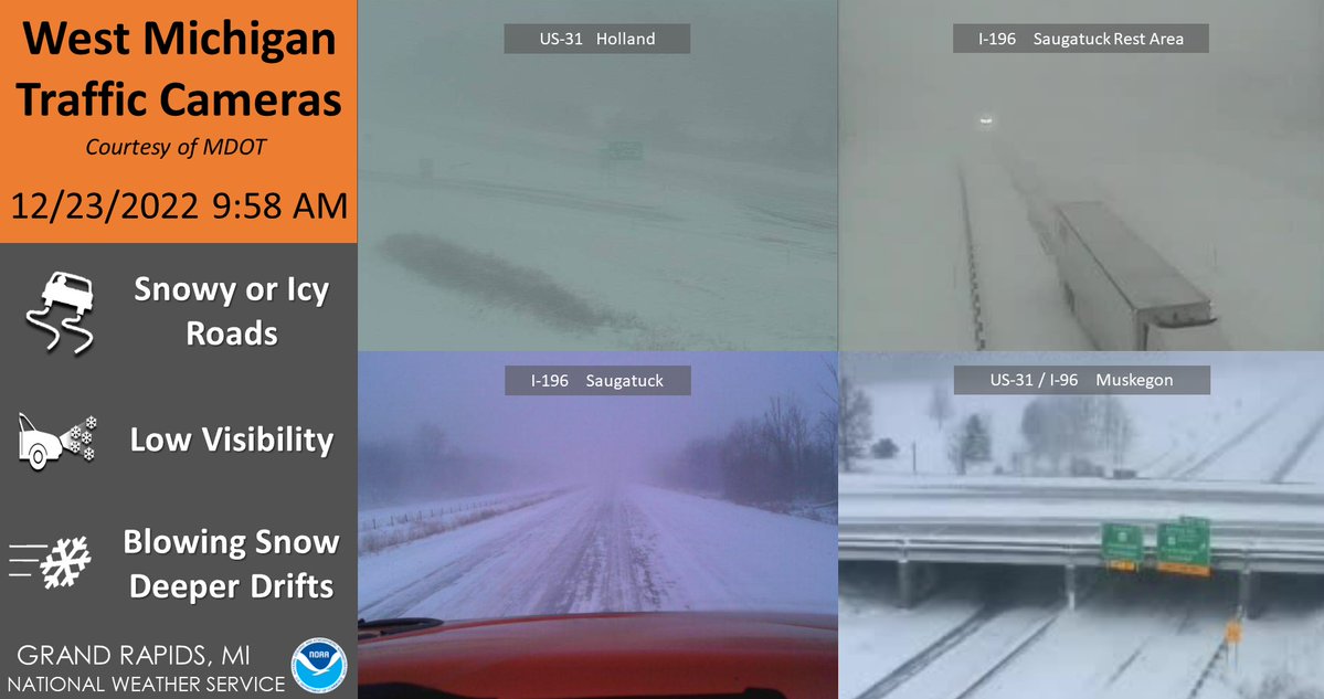
Various Traffic CAMs Friday 12/23/22 around 10 AM
|
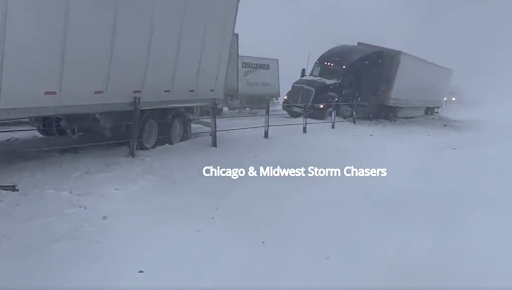
Pile-Up on EB-I94 near Watervilet, MI Friday 12/23/22
|
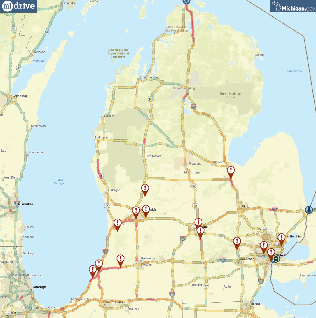
MiDrive Incident Map at Noon Friday, 12/23/22 |
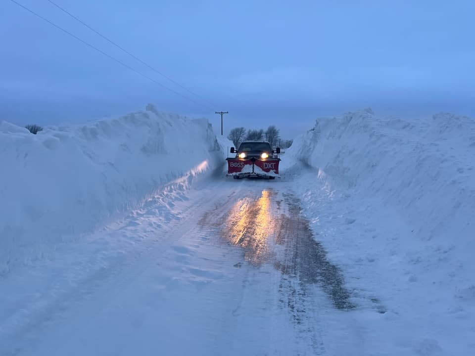
12/26 Hamilton MI After the Storm
|
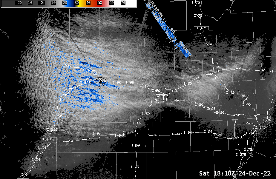
Radar
Storm Reports
Public Information Statement
National Weather Service Grand Rapids MI
1236 PM EST Sun Dec 25 2022

...72 HOUR SNOWFALL REPORTS...

Location                     Amount    Time/Date       Lat/Lon

...Michigan...

...Allegan County...
Plainwell 0.5 WSW            14.8 in   0700 AM 12/25   42.44N/85.65W
Holland 5.3 WSW              14.6 in   0800 AM 12/25   42.75N/86.20W
Otsego 0.9 WNW               11.0 in   1201 AM 12/25   42.46N/85.71W

...Barry County...
Hastings                     7.6 in    0700 AM 12/25   42.65N/85.30W
Plainwell 5.4 E              7.3 in    0800 AM 12/25   42.45N/85.54W

...Calhoun County...
Springfield 0.6 WNW          7.0 in    0800 AM 12/25   42.33N/85.25W

...Clinton County...
Laingsburg 2.1 NW            9.0 in    0800 AM 12/25   42.91N/84.38W
Laingsburg 2.1 NNW           5.0 in    0900 AM 12/25   42.92N/84.37W
Saint Johns                  3.5 in    0900 AM 12/25   43.02N/84.55W

...Eaton County...
Lansing 4.7 NW               11.5 in   0700 AM 12/25   42.75N/84.62W
1.3 NW Grand Ledge           5.0 in    0700 AM 12/25   42.77N/84.77W

...Gratiot County...
Alma 0.3 NW                  4.0 in    0700 AM 12/25   43.38N/84.66W

...Ingham County...
Okemos 0.6 ESE               14.1 in   0700 AM 12/25   42.71N/84.40W
Williamston 4.0 ESE          9.3 in    0800 AM 12/25   42.66N/84.22W
Lansing 1.0 ENE              8.0 in    0800 AM 12/25   42.71N/84.53W

...Ionia County...
Saranac 2.6 NE               8.9 in    0630 AM 12/25   42.96N/85.17W
Ionia 3 W                    4.3 in    0700 AM 12/25   42.98N/85.12W

...Isabella County...
Mount Pleasant 1.4 S         4.2 in    0700 AM 12/25   43.58N/84.77W
4 SSE Shepherd               3.5 in    0700 AM 12/25   43.47N/84.67W

...Jackson County...
Jackson 3.2 W                4.0 in    0700 AM 12/25   42.24N/84.47W
Hanover 3.8 W                1.6 in    0737 AM 12/25   42.11N/84.63W

...Kalamazoo County...
Portage 5.6 E                6.0 in    0800 AM 12/25   42.21N/85.48W

...Kent County...
Grand Rapids 2.9 NW          25.5 in   0700 AM 12/25   42.99N/85.69W
Grandville 1.3 WSW           22.7 in   0800 AM 12/25   42.90N/85.78W
NWS Grand Rapids             22.7 in   0700 AM 12/25   42.89N/85.54W
Grandville                   22.5 in   0700 AM 12/25   42.90N/85.76W
East Grand Rapids            19.3 in   0700 AM 12/25   42.94N/85.61W
Caledonia 4.4 WNW            13.5 in   0720 AM 12/25   42.83N/85.59W
Grand Rapids 2.5 ENE         10.0 in   0700 AM 12/25   42.97N/85.61W
Ada 1.8 W                    10.0 in   0845 AM 12/25   42.95N/85.53W
Ada 0.7 SE                   9.8 in    0700 AM 12/25   42.95N/85.48W
Belmont 1.0 WNW              9.6 in    0700 AM 12/25   43.08N/85.63W

...Mecosta County...
Big Rapids Water Works       9.0 in    0700 AM 12/25   43.70N/85.48W
Big Rapids 3.1 SE            4.1 in    0700 AM 12/25   43.68N/85.44W

...Newaygo County...
1.2 N Brunswick              10.5 in   0730 AM 12/25   43.45N/86.03W
White Cloud 7.5 ENE          6.1 in    0700 AM 12/25   43.61N/85.64W

...Ottawa County...
Walker 5.1 W                 15.4 in   0700 AM 12/25   42.99N/85.85W
Holland 3.9 NNE              15.0 in   0600 AM 12/25   42.82N/86.07W
Holland 4.2 NW               15.0 in   0700 AM 12/25   42.82N/86.15W
Holland 4.3 NNW              9.5 in    0700 AM 12/25   42.82N/86.15W
Holland Water Treatment      5.0 in    0600 AM 12/25   42.80N/86.12W

...Van Buren County...
Gobles 1.0 ESE               15.0 in   0834 AM 12/25   42.36N/85.86W
Paw Paw 2.0 NE               13.5 in   0700 AM 12/25   42.24N/85.86W
Paw Paw 3.6 NNE              13.0 in   0715 AM 12/25   42.27N/85.86W

Observations are collected from a variety of sources with varying
equipment and exposures. We thank all volunteer weather observers
for their dedication. Not all data listed are considered official.
Significant drifting snow up to 4 feet occurred and measurements
should not be considered precise.
Storm Environment
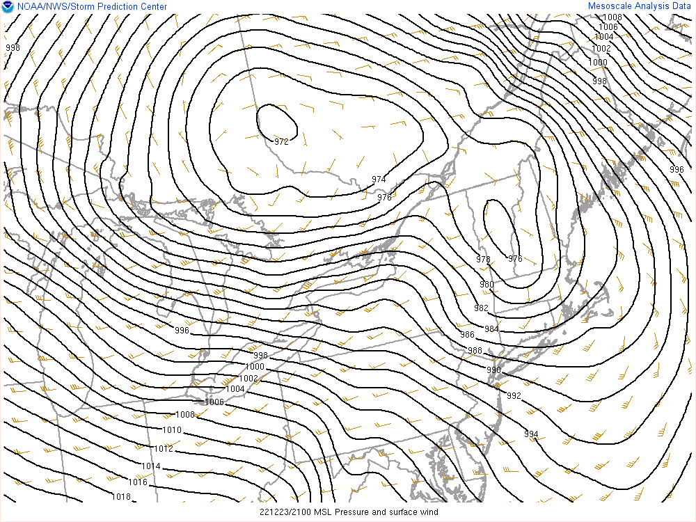
Slow moving surface low pressure deepened rapidly Thursday night and Friday just east and northeast of Michigan, with bitter cold Arctic air flowing into the region from the west around the south side of the low. The Arctic air mass crossing the warmer waters of Lake Michigan created heavy lake effect snow and the strong winds carried the accumulating snow well inland. The snow was easily lofted by the gusty winds causing frequent whiteouts and drifting snow.
 |
.gif) |
 |
|
Figure 1: Surface Pressure Analysis Friday 12/23, 4 PM EST
|
Figure 2: Surface Observations Friday 12/23, 4PM EST
|
Figure 3: Observed Wind Gusts (Knots) Friday 12/23, 4PM EST
|
 |
Media use of NWS Web News Stories is encouraged! Please acknowledge the NWS as the source of any news information accessed from this site. |
|

