
Dangerous heat will expand from the Gulf Coast into the Southern Plains and Desert Southwest through week's end. Additional extreme heat impacting the Pacific Northwest will shift to the northern Plains by the weekend. Tropical Storm Bertha is expected to continue to impact portions of the northern Gulf Coast from the western Florida Panhandle to southeastern Louisiana through tonight. Read More >
Overview
An arctic cold front moved across Southwest Lower Michigan during the evening of Wednesday December 4, 2024. Wind gusts with this front were very strong, resulting in power outages and some damage especially near the lakeshore. Snow squalls accompanying the front brought white-out conditions as well as a rare lightning show. Precipitation that was a mix of rain and snow near the lakeshore became all snow farther inland as the cold front moved across southern Lower Michigan.
Wind
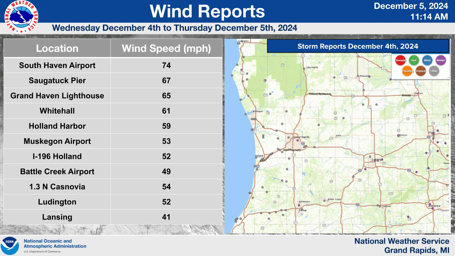 |
| Peak wind reports December 4 to 5, 2024 (Click to enlarge) |
Public Information Statement
National Weather Service Grand Rapids MI
1027 PM EST Wed Dec 4 2024

...HIGHEST WIND REPORTS AS OF 1025 PM 12/4/24...

Location                     Speed     Time/Date       Lat/Lon

...Michigan...

...Allegan County...
I-196 Mile Marker 38.1       57 MPH    0837 PM 12/04   42.65N/86.19W
US-31 Mile Marker 47.0 Holla 52 MPH    0707 PM 12/04   42.75N/86.12W
W Mich Regional Arpt         52 MPH    0816 PM 12/04   42.75N/86.10W
Allegan                      46 MPH    0720 PM 12/04   42.53N/85.83W
Holland                      46 MPH    0918 PM 12/04   42.46N/86.11W
Hopkins                      44 MPH    0720 PM 12/04   42.65N/85.76W
Allegan                      43 MPH    0715 PM 12/04   42.52N/85.77W
North Dorr                   42 MPH    0739 PM 12/04   42.76N/85.73W

...Calhoun County...
Battle Creek Executive Airpo 49 MPH    0800 PM 12/04   42.32N/85.23W

...Eaton County...
Charlotte Fitch Beach Arpt   41 MPH    0947 PM 12/04   42.57N/84.82W

...Jackson County...
Jackson                      46 MPH    0910 PM 12/04   42.26N/84.44W
Jackson County-Reynolds Fiel 45 MPH    0849 PM 12/04   42.27N/84.47W

...Kalamazoo County...
Kalamazoo/BC Intl Airport    48 MPH    0928 PM 12/04   42.23N/85.55W

...Kent County...
1.3 NE Casnovia (MAWN)       54 MPH    0800 PM 12/04   43.25N/85.77W
Gerald R Ford Intl           49 MPH    0800 PM 12/04   42.88N/85.52W
US-131 Mile Marker 104.7     45 MPH    0722 PM 12/04   43.22N/85.57W
I-96 Mile Marker 52.2        45 MPH    0842 PM 12/04   42.88N/85.37W
I-96 Mile Marker 45.7        44 MPH    0732 PM 12/04   42.89N/85.49W
Grand Rapids                 43 MPH    0715 PM 12/04   42.98N/85.74W
M-6 Mile Marker 12.7         42 MPH    0807 PM 12/04   42.85N/85.58W

...Mason County...
Ludington                    52 MPH    0625 PM 12/04   43.95N/86.46W

...Mecosta County...
US-131 Mile Marker 138.7     46 MPH    0812 PM 12/04   43.69N/85.52W

...Montcalm County...
M-57 Mile Marker 32.0        44 MPH    0922 PM 12/04   43.18N/84.96W

...Muskegon County...
Whitehall                    61 MPH    0700 PM 12/04   43.37N/86.42W
Muskegon County Airport      53 MPH    0802 PM 12/04   43.17N/86.23W
Norton Shores                51 MPH    0635 PM 12/04   43.17N/86.26W
US 31 Mile Marker 128.8      43 MPH    0647 PM 12/04   43.41N/86.31W
Mi-03 Us-31 At I-96          41 MPH    0717 PM 12/04   43.17N/86.21W

...Newaygo County...
Fremont Municipal Arpt       40 MPH    0715 PM 12/04   43.43N/86.00W

...Oceana County...
US 31 Mile Marker 140.7      51 MPH    0702 PM 12/04   43.56N/86.39W
M-20 Mile Marker 16.6        50 MPH    0707 PM 12/04   43.57N/86.07W
Shelby                       49 MPH    0601 PM 12/04   43.62N/86.54W
Pentwater                    49 MPH    0700 PM 12/04   43.81N/86.38W
2 NE Shelby                  46 MPH    0715 PM 12/04   43.64N/86.33W
1.4 NE New Era (MAWN)        41 MPH    0700 PM 12/04   43.58N/86.33W
Mears (MAWN)                 40 MPH    1000 PM 12/04   43.68N/86.41W

...Ottawa County...
Holland Harbor               59 MPH    0806 PM 12/04   42.77N/86.20W
GRAND HAVEN                  52 MPH    0645 PM 12/04   43.06N/86.25W
I-196 Mile Marker 62.3       51 MPH    0707 PM 12/04   42.85N/85.86W
I-196 Mile Marker 55.5       51 MPH    0708 PM 12/04   42.81N/85.98W
Grand Haven                  46 MPH    0805 PM 12/04   43.00N/86.10W
ALLENDALE                    44 MPH    0710 PM 12/04   42.97N/85.89W
Grand Haven                  43 MPH    0642 PM 12/04   42.98N/86.10W
1.4 W Hudsonville (MAWN)     43 MPH    0800 PM 12/04   42.86N/85.89W
I-96 Mile Marker 7.8         42 MPH    0647 PM 12/04   43.09N/86.10W
Mi-03 Coopersville           42 MPH    0657 PM 12/04   43.05N/85.91W
1.1 W Wright (MAWN)          41 MPH    0800 PM 12/04   43.12N/85.83W
Jamestown                    40 MPH    0715 PM 12/04   42.83N/85.83W

...Van Buren County...
South Haven Rgnl Arpt        74 MPH    0655 PM 12/04   42.35N/86.25W
I-94 Mile Marker 47.7        51 MPH    0717 PM 12/04   42.19N/86.13W
I-94 Mile Marker 53.8        50 MPH    0807 PM 12/04   42.19N/86.01W
I-94 Mile Marker 63.0        45 MPH    0907 PM 12/04   42.22N/85.84W
1 ENE Grand Junction         44 MPH    0655 PM 12/04   42.41N/86.05W
I-94 Mile Marker 65.9        41 MPH    0817 PM 12/04   42.22N/85.78W
I-94 Mile Marker 58.7        40 MPH    0802 PM 12/04   42.20N/85.92W
Lawton                       40 MPH    0820 PM 12/04   42.17N/85.82W

...Maritime Stations...
Saugatuck Pier               67 MPH    0708 PM 12/04   42.68N/86.22W
St. Joseph Pier              63 MPH    0712 PM 12/04   42.12N/86.49W
Saint Joseph                 57 MPH    0725 PM 12/04   42.13N/86.47W
South Haven                  56 MPH    1000 PM 12/04   42.40N/86.29W
Southern Lake Michigan Buoy  51 MPH    0750 PM 12/04   42.67N/87.03W

Observations are collected from a variety of sources with varying
equipment and exposures. We thank all volunteer weather observers
for their dedication. Not all data listed are considered official.

$$
Snow
Public Information Statement
National Weather Service Grand Rapids MI
1044 AM EST Thu Dec 5 2024

...SNOWFALL REPORTS...

Location                     Amount    Time/Date       Lat/Lon

...Michigan...

...Allegan County...
Plainwell 0.5 WSW            5.7 in    0700 AM 12/05   42.44N/85.65W

...Barry County...
Plainwell 5.4 E              4.5 in    0800 AM 12/05   42.45N/85.54W
4 SSW Hastings               2.5 in    0600 AM 12/05   42.59N/85.32W
Hastings                     2.5 in    0700 AM 12/05   42.65N/85.30W

...Calhoun County...
Battle Creek 0.6 S           2.4 in    0750 AM 12/05   42.29N/85.23W

...Clare County...
Harrison 5.2 ESE             4.0 in    0735 AM 12/05   43.99N/84.70W

...Clinton County...
Haslett 1.2 N                3.0 in    0700 AM 12/05   42.77N/84.40W
Laingsburg 2.1 NW            2.0 in    0800 AM 12/05   42.91N/84.38W
2 WSW Laingsburg             1.5 in    0700 AM 12/05   42.87N/84.38W
Laingsburg 2.1 NNW           1.0 in    0900 AM 12/05   42.92N/84.37W

...Eaton County...
Dimondale                    4.8 in    1050 PM 12/04   42.65N/84.65W
Lansing 4.7 NW               3.1 in    0700 AM 12/05   42.75N/84.62W
1 NNW Waverly                3.1 in    0700 AM 12/05   42.75N/84.63W
Bellevue 1.9 ENE             2.0 in    0600 AM 12/05   42.45N/84.98W
1.3 NW Grand Ledge           1.0 in    0700 AM 12/05   42.77N/84.77W
0.5 NE Eaton Rapids          1.0 in    0800 AM 12/05   42.52N/84.65W

...Ingham County...
Williamston 3.8 NNW          4.5 in    0700 AM 12/05   42.74N/84.32W
Williamston 4.0 ESE          4.0 in    0800 AM 12/05   42.66N/84.22W
Okemos 0.6 ESE               3.8 in    0700 AM 12/05   42.71N/84.40W
Haslett 1.6 ESE              3.6 in    0800 AM 12/05   42.75N/84.38W
Edgemont Park 0.7 NNE        3.5 in    0700 AM 12/05   42.76N/84.59W
Haslett                      3.3 in    0959 PM 12/04   42.75N/84.41W
Lansing 1.0 ENE              3.0 in    0800 AM 12/05   42.71N/84.53W
1 NNE East Lansing           3.0 in    0813 AM 12/05   42.75N/84.48W
1 E East Lansing             2.5 in    0953 PM 12/04   42.74N/84.47W
1 WNW East Lansing           2.1 in    1031 PM 12/04   42.74N/84.51W
Leslie 4.3 E                 1.1 in    0800 AM 12/05   42.45N/84.35W

...Ionia County...
Saranac 2.6 NE               1.7 in    0630 AM 12/05   42.96N/85.17W
Ionia 3 W                    1.2 in    0700 AM 12/05   42.98N/85.12W

...Isabella County...
Mount Pleasant 1.4 NE        3.5 in    0700 AM 12/05   43.61N/84.76W
Mount Pleasant 7.0 ENE       3.4 in    0700 AM 12/05   43.63N/84.65W

...Jackson County...
Jackson 3.2 W                3.0 in    0700 AM 12/05   42.24N/84.47W

...Kalamazoo County...
3 W Portage                  5.0 in    0800 AM 12/05   42.21N/85.66W
Kalamazoo 5.6 E              4.5 in    0800 AM 12/05   42.27N/85.48W
Kalamazoo                    2.5 in    1045 PM 12/04   42.27N/85.59W

...Kent County...
Sparta 5.7 ENE               4.3 in    0815 AM 12/05   43.18N/85.60W
Kentwood 4 ENE               3.2 in    0700 AM 12/05   42.89N/85.54W
Grandville                   2.4 in    0700 AM 12/05   42.90N/85.76W
3 NW Cannonsburg             2.2 in    0825 AM 12/05   43.10N/85.51W
East Grand Rapids            2.0 in    0700 AM 12/05   42.94N/85.61W
East Grand Rapids 0.7 SSW    2.0 in    0700 AM 12/05   42.94N/85.61W
East Grand Rapids            1.7 in    1007 PM 12/04   42.95N/85.61W
Grand Rapids 2.9 NW          1.5 in    0700 AM 12/05   42.99N/85.69W
Grand Rapids 3.0 NW          1.5 in    0700 AM 12/05   42.99N/85.69W
Caledonia 4.4 WNW            1.4 in    0700 AM 12/05   42.83N/85.59W
Belmont 1.0 WNW              1.0 in    0700 AM 12/05   43.08N/85.63W

...Mason County...
Scottville 2.1 ESE           4.5 in    0700 AM 12/05   43.93N/86.25W
Scottville 2 SE              4.5 in    0700 AM 12/05   43.93N/86.25W
Ludington 6 NNW              3.3 in    0815 AM 12/05   44.03N/86.50W

...Mecosta County...
Big Rapids Water Works       4.0 in    0700 AM 12/05   43.70N/85.48W
Big Rapids 3.1 SE            3.0 in    0700 AM 12/05   43.68N/85.44W

...Muskegon County...
Roosevelt Park               2.1 in    0700 AM 12/05   43.20N/86.27W

...Newaygo County...
1.2 N Brunswick              8.0 in    0730 AM 12/05   43.45N/86.03W
White Cloud 7.5 ENE          3.0 in    0640 AM 12/05   43.61N/85.64W

...Oceana County...
Hesperia                     8.0 in    0956 AM 12/05   43.57N/86.04W
Hart                         1.2 in    0700 AM 12/05   43.70N/86.37W
Hart 3 WSW                   1.2 in    0700 AM 12/05   43.67N/86.42W

...Osceola County...
Reed City Wwtp               4.5 in    0700 AM 12/05   43.87N/85.50W

...Ottawa County...
Holland 4.2 NW               5.0 in    0700 AM 12/05   42.82N/86.15W
Holland 3.9 NNE              2.5 in    0600 AM 12/05   42.82N/86.07W
Holland 4.3 NNW              2.5 in    0700 AM 12/05   42.82N/86.15W
Holland                      2.0 in    0644 AM 12/05   42.80N/86.12W
Walker 5.1 W                 1.8 in    0700 AM 12/05   42.99N/85.85W

...Van Buren County...
Gobles 1.0 ESE               5.2 in    0827 AM 12/05   42.36N/85.86W
Paw Paw 3.6 NNE              3.5 in    0700 AM 12/05   42.27N/85.86W
Paw Paw 2.0 NE               2.0 in    0700 AM 12/05   42.24N/85.86W

Observations are collected from a variety of sources with varying
equipment and exposures. We thank all volunteer weather observers
for their dedication. Not all data listed are considered official.

$$
Lightning
A very unusual aspect of this event was the lightning that occurred. This likely had to do with the unusual amount of liquid water that was present, given it was initially raining by the lakeshore. The graphic below shows lighting that was reported. Lightning plots for the past 7 days are available here.
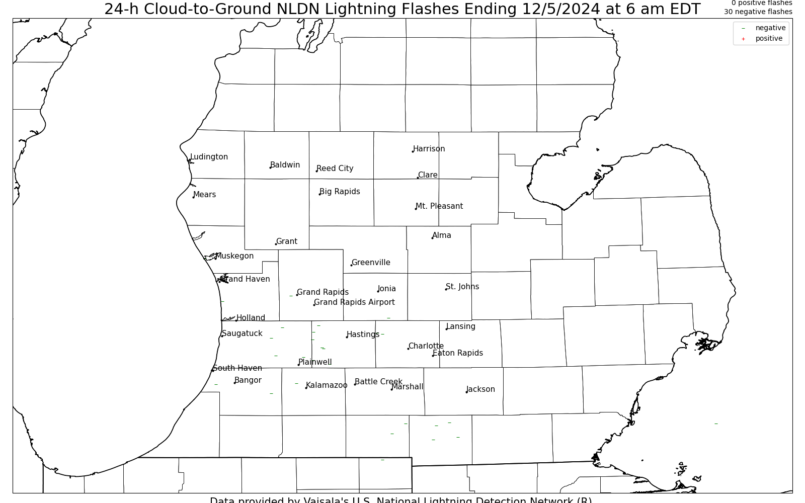 |
| 24 hour lightning strikes ending at 6 am EST Thursday December 6, 2024 |
Radar
Loop of snow squall moving across Southwest Lower Michigan
 |
Media use of NWS Web News Stories is encouraged! Please acknowledge the NWS as the source of any news information accessed from this site. |
|

