
Wildfire smoke will push into the Midwest, worsening air quality. A frontal system brings severe storms from the Northern Plains to the Mid‑Atlantic the next few days. Heavy Gulf Coast rain is possible as Tropical Depression Two has formed, while monsoonal storms persist in the Southwest with heavy rainfall. Hazardous heat expands from the Plains into the Lower Mississippi Valley. Read More >
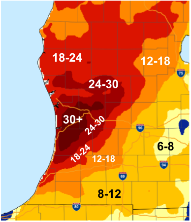
Location                     Amount    Time/Date       Lat/Lon

...Michigan...

...Allegan County...
Otsego 0.9 WNW               11.8 in   1000 AM 01/17   42.46N/85.71W
Plainwell 0.5 WSW            11.7 in   0700 AM 01/17   42.44N/85.65W

...Barry County...
Plainwell 5.4 E              9.7 in    0800 AM 01/17   42.45N/85.54W
4 SSW Hastings               9.0 in    0600 AM 01/17   42.59N/85.32W
Hastings                     8.8 in    0700 AM 01/17   42.65N/85.30W

...Clare County...
Harrison 5.2 ESE             8.2 in    0800 AM 01/17   43.99N/84.70W

...Clinton County...
Laingsburg 2.1 NW            6.0 in    0800 AM 01/17   42.91N/84.38W
Laingsburg 2.1 NNW           5.4 in    0900 AM 01/17   42.92N/84.37W

...Eaton County...
Charlotte                    6.5 in    0700 AM 01/17   42.55N/84.83W
Lansing 4.7 NW               6.0 in    0700 AM 01/17   42.75N/84.62W
1.3 NW Grand Ledge           5.0 in    0700 AM 01/17   42.77N/84.77W
0.5 NE Eaton Rapids          4.5 in    0800 AM 01/17   42.52N/84.65W

...Gratiot County...
Alma 0.3 NW                  10.5 in   0700 AM 01/17   43.38N/84.66W

...Ingham County...
Williamston 4.0 ESE          5.0 in    0800 AM 01/17   42.66N/84.22W
Lansing 1.0 ENE              4.6 in    0800 AM 01/17   42.71N/84.53W

...Ionia County...
Ionia 3 W                    14.1 in   0700 AM 01/17   42.98N/85.12W
Saranac 2.6 NE               14.0 in   0630 AM 01/17   42.96N/85.17W

...Isabella County...
4 SSE Shepherd               8.7 in    0700 AM 01/17   43.47N/84.67W

...Jackson County...
Jackson 3.2 W                7.0 in    0700 AM 01/17   42.24N/84.47W


...Kalamazoo County...
3 W Portage                  8.4 in    0800 AM 01/17   42.21N/85.66W
Portage 0.8 WSW              8.0 in    0800 AM 01/17   42.20N/85.60W
Portage 5.6 E                7.4 in    0800 AM 01/17   42.21N/85.48W

...Kent County...
Lowell Wwtp                  31.6 in   0800 AM 01/17   42.93N/85.33W
3 NW Cannonsburg             27.5 in   0845 AM 01/17   43.10N/85.51W
Grand Rapids 2.9 NW          27.5 in   0700 AM 01/17   42.99N/85.69W
Grandville 1.3 WSW           23.4 in   0700 AM 01/17   42.90N/85.78W
Grand Rapids 3.0 NW          22.4 in   0800 AM 01/17   42.99N/85.69W
East Grand Rapids            21.9 in   0700 AM 01/17   42.94N/85.61W
East Grand Rapids 0.7 SSW    21.9 in   0700 AM 01/17   42.94N/85.61W
Ada 0.7 SE                   18.4 in   0700 AM 01/17   42.95N/85.48W
Belmont 1.0 WNW              17.6 in   0700 AM 01/17   43.08N/85.63W
Grandville                   17.2 in   0700 AM 01/17   42.90N/85.76W
Lowell 5.5 N                 16.6 in   0700 AM 01/17   43.01N/85.35W
Caledonia 4.4 WNW            15.8 in   0800 AM 01/17   42.83N/85.59W

...Mason County...
Ludington 6 NNW              9.1 in    0815 AM 01/17   44.03N/86.50W

...Mecosta County...
Big Rapids Water Works       21.0 in   0700 AM 01/17   43.70N/85.48W

...Montcalm County...
1 SSW Vestaburg              10.5 in   1100 AM 01/17   43.38N/84.91W
Edmore 3.8 ESE               8.0 in    0930 AM 01/17   43.38N/84.97W

...Newaygo County...
1.2 N Brunswick              15.5 in   0730 AM 01/17   43.45N/86.03W

...Oceana County...
Hart                         14.5 in   0700 AM 01/17   43.70N/86.37W
Hart 3 WSW                   14.5 in   0700 AM 01/17   43.67N/86.42W

...Osceola County...
Reed City Wwtp               11.5 in   0700 AM 01/17   43.87N/85.50W

...Ottawa County...
Walker 5.1 W                 26.4 in   0700 AM 01/17   42.99N/85.85W
Holland 3.9 NNE              25.0 in   0600 AM 01/17   42.82N/86.07W
Holland 4.2 NW               19.0 in   0700 AM 01/17   42.82N/86.15W
Holland                      5.3 in    0600 AM 01/17   42.80N/86.12W

...Van Buren County...
Gobles 1.0 ESE               18.0 in   0841 AM 01/17   42.36N/85.86W
Paw Paw 2.0 NE               11.6 in   0700 AM 01/17   42.24N/85.86W
Paw Paw 3.6 NNE              11.3 in   0715 AM 01/17   42.27N/85.86W

Observations are collected from a variety of sources with varying
equipment and exposures. We thank all volunteer weather observers
for their dedication. Not all data listed are considered official.
Very cold air responsible for the lake effect snow also resulted in hazardous wind chill readings.
...MINIMUM WIND CHILL REPORTS...

Location                     WC Temp.  Time/Date       Lat/Lon

...Michigan...

...Allegan County...
Hopkins                      -24 F     1020 PM 01/14   42.64N/85.68W
North Dorr                   -23 F     0351 AM 01/15   42.76N/85.73W
W Mich Regional Arpt         -22 F     0753 PM 01/14   42.75N/86.10W
US-31 Mile Marker 47.0 Holla -22 F     0803 PM 01/14   42.75N/86.12W
Allegan                      -22 F     0931 PM 01/14   42.52N/85.77W
Allegan                      -20 F     0925 PM 01/14   42.53N/85.83W
Plainwell                    -20 F     1210 AM 01/15   42.66N/85.65W
HOPKINS                      -19 F     0240 AM 01/15   42.65N/85.76W
3.6 SE Allegan (MAWN)        -16 F     0900 PM 01/14   42.49N/85.80W
I-196 Mile Marker 38.1       -16 F     0413 AM 01/15   42.65N/86.19W
Fennville                    -15 F     0845 AM 01/15   42.60N/86.10W

...Barry County...
Hastings                     -23 F     0725 PM 01/14   42.66N/85.34W
2.6 W Dowling (MAWN)         -15 F     1100 PM 01/14   42.53N/85.30W

...Calhoun County...
Fulton                       -31 F     0905 AM 01/15   42.11N/85.26W
1 N Battle Creek             -30 F     0215 AM 01/15   42.34N/85.18W
Battle Creek Executive Airpo -28 F     0853 AM 01/15   42.32N/85.23W
Marshall Brooks Field        -25 F     0735 AM 01/15   42.23N/84.95W
1.4 NW Albion (MAWN)         -20 F     0900 AM 01/15   42.26N/84.77W

...Clinton County...
Lansing                      -23 F     0353 AM 01/15   42.78N/84.58W
Haslett                      -15 F     0215 AM 01/15   42.77N/84.41W

...Eaton County...
Grand Ledge                  -23 F     0815 AM 01/15   42.72N/84.82W
Charlotte Fitch Beach Arpt   -19 F     0715 AM 01/15   42.57N/84.82W

...Gratiot County...
Alma                         -21 F     1235 AM 01/15   43.32N/84.68W
Saint Louis                  -20 F     0140 AM 01/15   43.41N/84.61W

...Ingham County...
Williamston                  -22 F     0830 PM 01/14   42.70N/84.28W
2.0 NW Leslie (MAWN)         -22 F     0900 AM 01/15   42.47N/84.46W
Mason Jewett Arpt            -21 F     0835 PM 01/14   42.57N/84.42W
3.2 NE Holt (MAWN)           -21 F     0400 AM 01/15   42.67N/84.49W
1.8 S East Lansing (MAWN)    -20 F     0200 AM 01/15   42.71N/84.48W
3.0 SW Shaftsburg (MAWN)     -18 F     0400 AM 01/15   42.77N/84.33W

...Ionia County...
2.4 NW Clarksville (MAWN)    -22 F     0900 PM 01/14   42.87N/85.26W
1 NNE Woodbury               -22 F     1235 AM 01/15   42.79N/85.07W
Ionia County Arpt            -21 F     0855 PM 01/14   42.93N/85.07W
Portland                     -21 F     0105 AM 01/15   42.90N/84.98W
I-96 Mile Marker 76.0        -21 F     0116 AM 01/15   42.86N/84.91W
Belding                      -19 F     1035 PM 01/14   43.10N/85.22W
4.4 NW Smyrna (MAWN)         -18 F     0300 AM 01/15   43.11N/85.31W
Saranac                      -17 F     1133 PM 01/14   42.96N/85.20W

...Isabella County...
B-3 M-20 At Costabella Ave   -17 F     0743 AM 01/15   43.60N/85.09W
Mt Pleasant Muni Arpt        -16 F     0535 AM 01/15   43.62N/84.73W

...Jackson County...
Jackson County-Reynolds Fiel -28 F     0212 AM 01/15   42.27N/84.47W
Jackson                      -26 F     0108 AM 01/15   42.26N/84.44W
Grass Lake                   -22 F     0200 AM 01/15   42.24N/84.25W
1 E Clark Lake               -21 F     0445 AM 01/15   42.12N/84.32W
Parma                        -17 F     0636 AM 01/15   42.26N/84.60W
Oak Point                    -16 F     0925 AM 01/15   42.19N/84.25W
Spring Arbor                 -15 F     0915 AM 01/15   42.24N/84.50W

...Kalamazoo County...
2 W Schoolcraft              -30 F     0200 AM 01/15   42.12N/85.68W
Kalamazoo/BC Intl Airport    -28 F     1226 AM 01/15   42.23N/85.55W
Fulton                       -25 F     0730 AM 01/15   42.12N/85.37W
Kalamazoo                    -23 F     1207 AM 01/15   42.27N/85.76W
I-94 Mile Marker 69.2        -23 F     0131 AM 01/15   42.23N/85.72W
2.0 SE Cooper (MAWN)         -21 F     0800 PM 01/14   42.35N/85.59W
Msuwmu                       -21 F     0300 AM 01/15   42.26N/85.64W
1.3 NE Midland Park (MAWN)   -17 F     0300 PM 01/14   42.41N/85.37W
Kalamazoo                    -17 F     0645 AM 01/15   42.20N/85.69W

...Kent County...
Gerald R Ford Intl           -24 F     0820 PM 01/14   42.88N/85.52W
I-96 Mile Marker 52.2        -24 F     0128 AM 01/15   42.88N/85.37W
M-6 Mile Marker 12.7         -21 F     1235 AM 01/15   42.85N/85.58W
East Grand Rapids            -20 F     0430 AM 01/15   42.95N/85.61W
Lowell                       -19 F     0826 PM 01/14   43.02N/85.35W
Byron Center                 -18 F     0414 AM 01/15   42.80N/85.65W
Caledonia                    -17 F     0800 PM 01/14   42.83N/85.47W
US-131 Mile Marker 94.6      -17 F     0925 PM 01/14   43.09N/85.63W
2 WNW Kentwood               -17 F     0310 AM 01/15   42.90N/85.63W
I-96 Mile Marker 45.7        -17 F     0405 AM 01/15   42.89N/85.49W
Cedar Springs                -17 F     0518 AM 01/15   43.20N/85.59W
Grandville                   -16 F     0840 PM 01/14   42.90N/85.74W
2.7 E Wright (MAWN)          -16 F     0915 PM 01/14   43.12N/85.76W
Rockford                     -15 F     1125 PM 01/14   43.09N/85.47W
Byron Center                 -15 F     0530 AM 01/15   42.82N/85.64W

...Montcalm County...
M-57 Mile Marker 32.0        -23 F     1043 PM 01/14   43.18N/84.96W
M-46 Mile Marker 71.1        -20 F     1048 PM 01/14   43.41N/85.08W
3 S Lakeview                 -20 F     0540 AM 01/15   43.40N/85.28W
1.1 W Entrican (MAWN)        -18 F     1000 PM 01/14   43.35N/85.18W

...Ottawa County...
I-196 Mile Marker 62.3       -21 F     0542 AM 01/15   42.85N/85.86W
I-196 Mile Marker 55.5       -20 F     0743 PM 01/14   42.81N/85.98W
Zeeland                      -20 F     0455 AM 01/15   42.82N/86.03W
1 SSW Allendale              -19 F     0449 AM 01/15   42.96N/85.97W
1.4 W Hudsonville (MAWN)     -18 F     0500 AM 01/15   42.86N/85.89W
Jenison                      -16 F     0815 PM 01/14   42.90N/85.80W
Mi-03 Coopersville           -16 F     0849 PM 01/14   43.05N/85.91W

...Van Buren County...
2 SE Hartford                -31 F     0145 AM 01/15   42.17N/86.13W
2.2 SW Hartford (MAWN)       -28 F     0800 PM 01/14   42.18N/86.18W
I-94 Mile Marker 56.3        -28 F     0151 AM 01/15   42.20N/85.97W
I-94 Mile Marker 53.8        -28 F     0423 AM 01/15   42.19N/86.01W
Lawton                       -26 F     0715 PM 01/14   42.17N/85.82W
I-94 Mile Marker 58.7        -26 F     0144 AM 01/15   42.20N/85.92W
3.6 W Paw Paw (MAWN)         -25 F     0200 AM 01/15   42.21N/85.96W
South Haven Rgnl Arpt        -24 F     0735 PM 01/14   42.35N/86.25W
0.9 SE Lawton (MAWN)         -24 F     0200 AM 01/15   42.16N/85.83W
1.6 NE Hartford (MAWN)       -23 F     0200 AM 01/15   42.23N/86.16W
I-94 Mile Marker 63.0        -23 F     0320 AM 01/15   42.22N/85.84W
I-94 Mile Marker 65.9        -23 F     0321 AM 01/15   42.22N/85.78W
I-94 Mile Marker 47.7        -22 F     1255 AM 01/15   42.19N/86.13W
Lawrence                     -21 F     1225 AM 01/15   42.23N/86.06W
3.1 S South Haven (MAWN)     -15 F     0300 AM 01/15   42.36N/86.29W

...Maritime Stations...
Saint Joseph                 -29 F     0215 AM 01/15   42.13N/86.47W
Saint Joseph                 -29 F     0215 AM 01/15   42.13N/86.47W

Observations are collected from a variety of sources with varying
equipment and exposures. We thank all volunteer weather observers
for their dedication. Not all data listed are considered official.
 |
Media use of NWS Web News Stories is encouraged! Please acknowledge the NWS as the source of any news information accessed from this site. |
|

