
Dangerous heat will expand from the Gulf Coast into the Southern Plains and Desert Southwest through week's end. Additional extreme heat impacting the Pacific Northwest will shift to the northern Plains by the weekend. Tropical Storm Bertha is expected to continue to impact portions of the northern Gulf Coast from the western Florida Panhandle to southeastern Louisiana through tonight. Read More >
Overview
A major ice storm impacted much of southern Lower Michigan while areas of moderate to heavy snow impacted central Lower Michigan on February 22, 2023. Hundreds of thousands of customers lost power across southern portions of the state as freezing rain accumulated on trees and power lines, bringing branches, trees, and power lines down in many areas. In between the areas of freezing rain to the south and snow to the north, sleet (ice pellet) accumulation reached a couple of inches deep.
In order for freezing rain to occur, snowflakes that fall from the sky need to completely melt and not refreeze into ice pellets before reaching the ground. That was the case for most areas south of the I-96 corridor during this event. Along and slightly north of the I-96 corridor, ice pellets persisted for most of this event leading to 1"-2" of dense ice pellet accumulation. The environment stayed just cold enough above the surface to completely refreeze the melted snowflakes into sleet. Further north, the atmosphere was cold enough to keep precipitation all snow, where generally 2"-8" fell.
Wind gusts reached the 25-35 mph range for many locations during the height of the event. This added an additional challenge to areas that received heavy icing on trees and power lines.
Snow/Ice
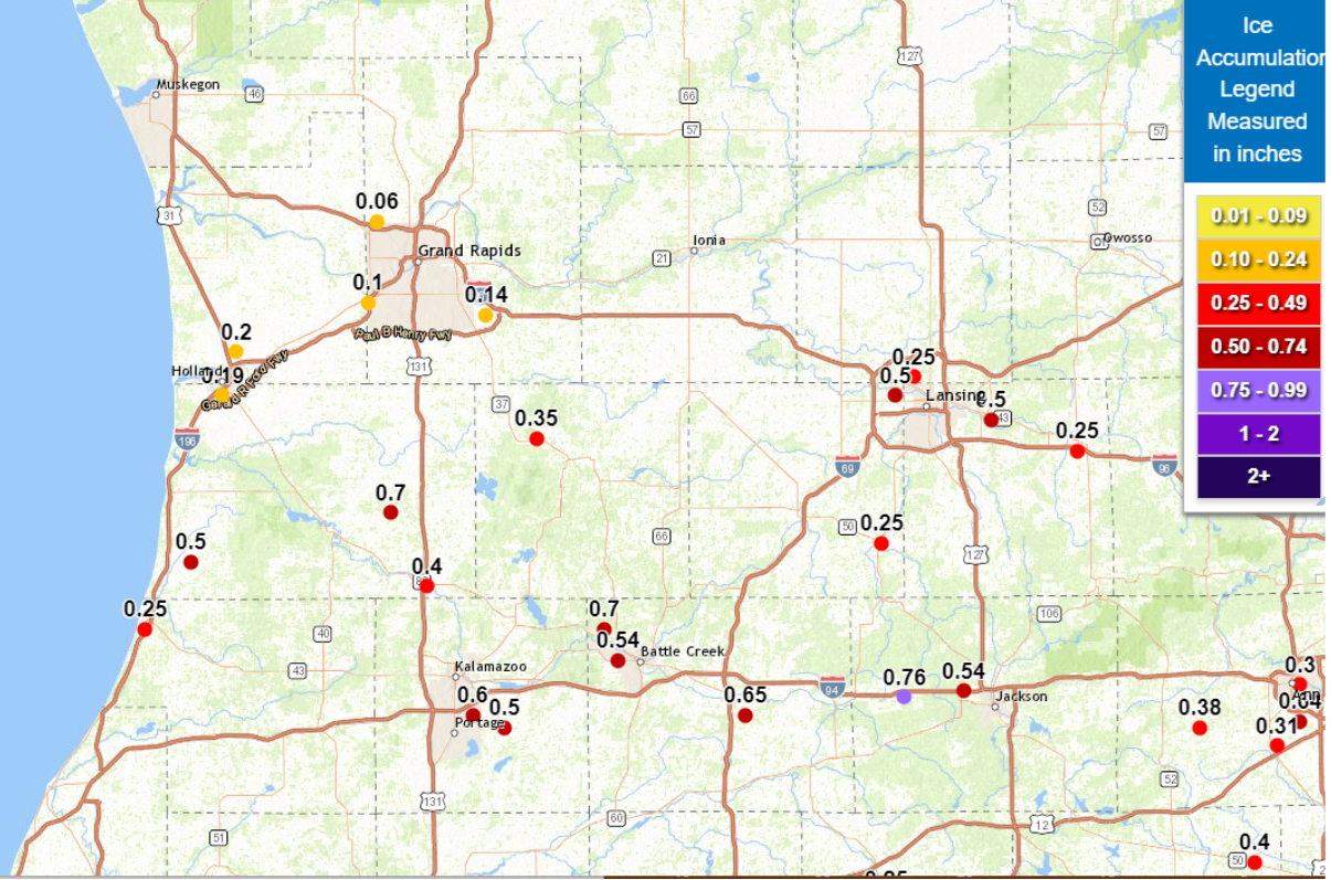
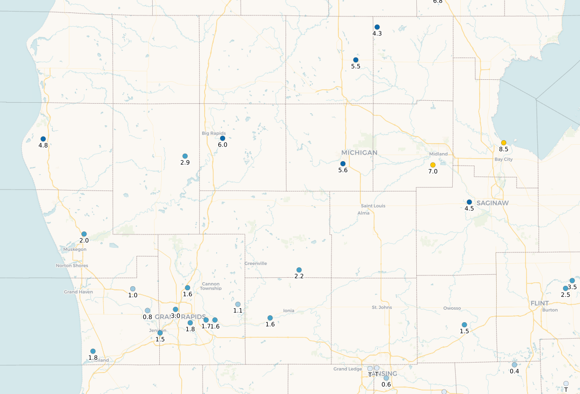
Storm total freezing rain accumulations ranged from a light glaze to 0.76" across southern portions of the state. Further north, generally 2"-8" of snow fell. The map below shows freezing rain values (plotted as "ZR" with the ice value proceeding it), and the second map shows snowfall accumulation reports.
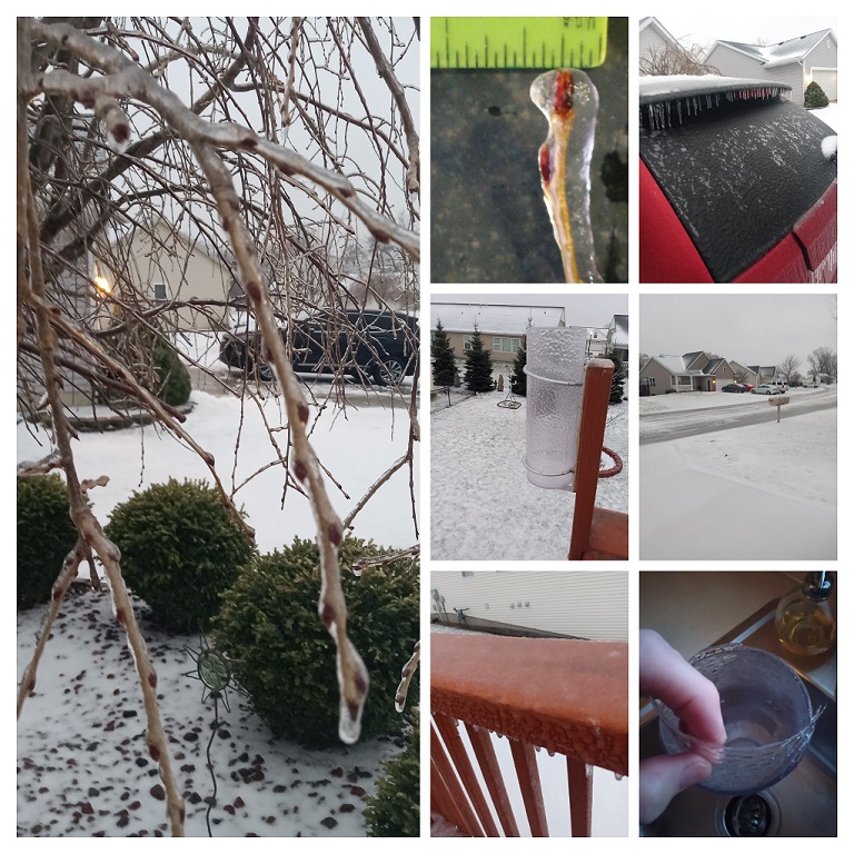
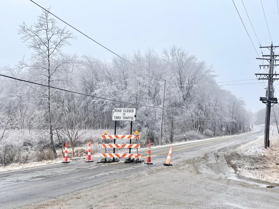
Photos & Video
 |
 |
||
|
4 NE of Holland (Photo by Dave Carmichael) |
Near Gobles (Photo by Kyle Piers) |
Caption (source) |
Caption (source) |
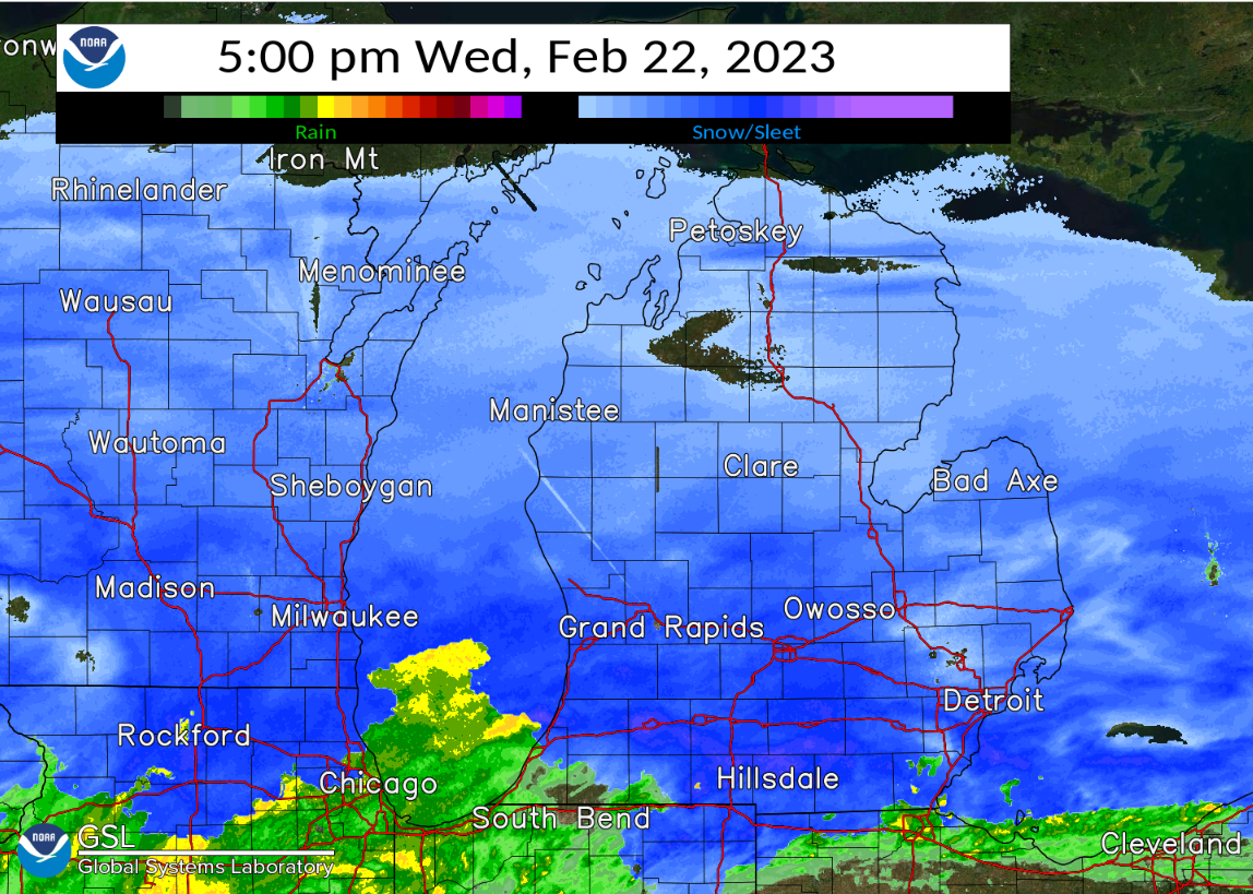
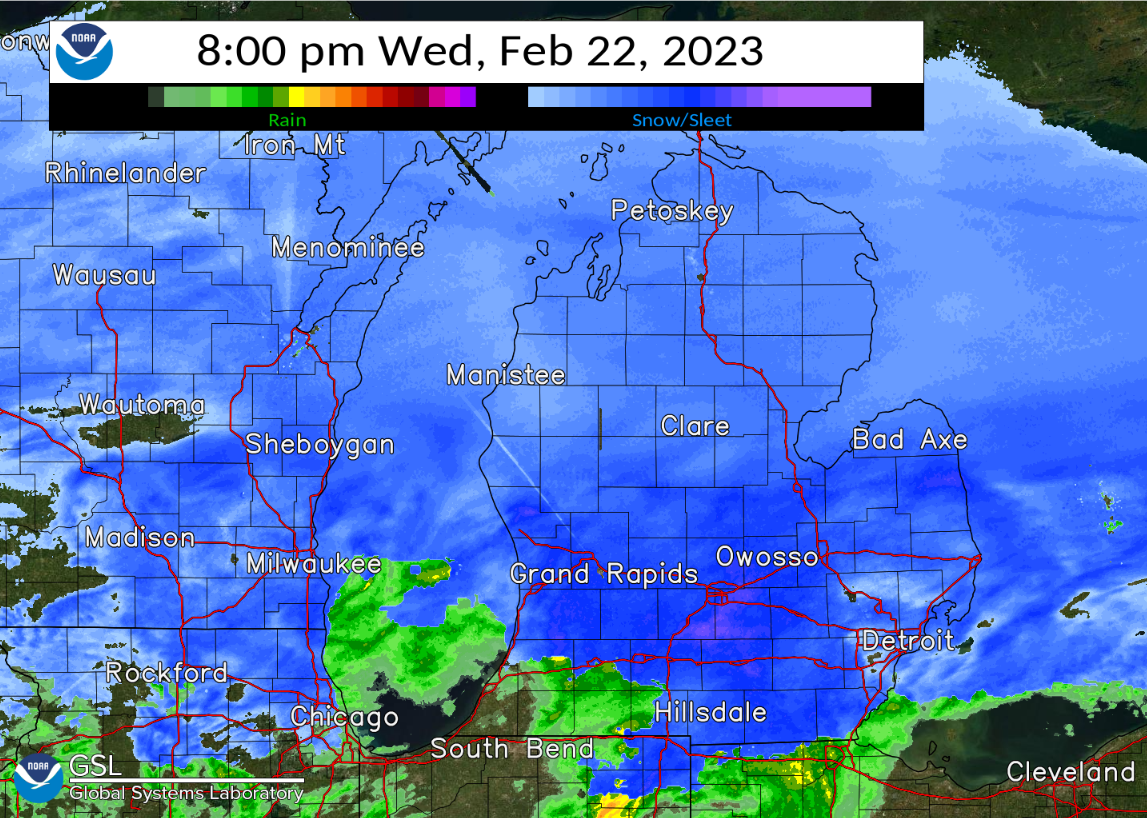
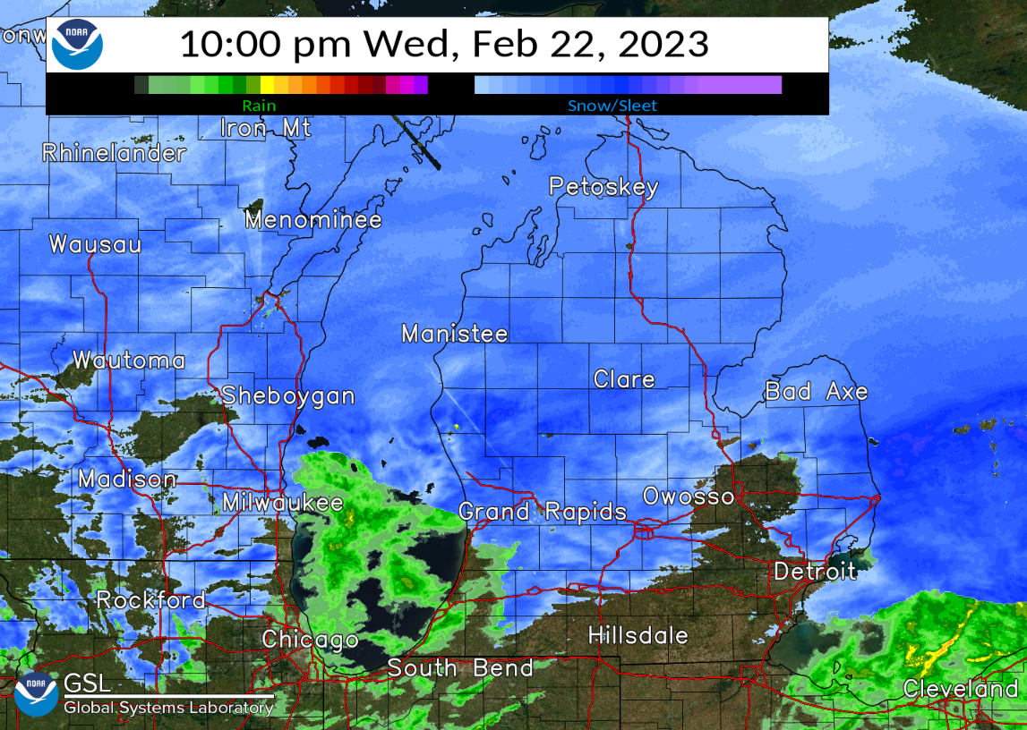
Radar
The regional radar snapshots below indicate where snow, sleet, and freezing rain (blue) occurred vs. where just rain occurred (green).
Storm Reports
Public Information Statement
National Weather Service Grand Rapids MI
1141 AM EST Thu Feb 23 2023

...WINTER STORM REPORT SUMMARY...

...SNOWFALL REPORTS...

Location                     Amount    Time/Date       Lat/Lon

...Michigan...

...Clare County...
Harrison 5.2 ESE             5.5 in    0720 AM 02/23   43.99N/84.70W

...Isabella County...
0.9 SE Mount Pleasant        7.5 in    0700 AM 02/23   43.59N/84.77W
5 SSE Delwin                 6.1 in    0854 PM 02/22   43.63N/84.65W
Mount Pleasant 1.4 S         5.6 in    0700 AM 02/23   43.58N/84.77W

...Kent County...
Grand Rapids 2.9 NW          3.0 in    0700 AM 02/23   42.99N/85.69W

...Mecosta County...
Big Rapids 3.1 SE            6.0 in    0700 AM 02/23   43.68N/85.44W
Big Rapids Water Works       5.2 in    0700 AM 02/23   43.70N/85.48W

...Montcalm County...
Fenwick 3.3 E                2.2 in    0700 AM 02/23   43.15N/85.01W

...Muskegon County...
North Muskegon 4.9 NE        2.0 in    0800 AM 02/23   43.29N/86.20W
Muskegon 4 SE                0.5 in    0613 AM 02/23   43.18N/86.20W

...Newaygo County...
1.2 N Brunswick              3.0 in    0730 AM 02/23   43.45N/86.03W
White Cloud 7.5 ENE          2.9 in    0700 AM 02/23   43.61N/85.64W
Fremont                      2.3 in    0600 PM 02/22   43.46N/85.95W

...Oceana County...
Hart 3 WSW                   4.8 in    0700 AM 02/23   43.67N/86.42W

...SLEET REPORTS...

Location                     Amount    Time/Date       Lat/Lon

...Michigan...

...Kent County...
2 W Ada                      1.7 in    1145 PM 02/22   42.95N/85.53W
1 WSW Grandville             1.5 in    1020 PM 02/22   42.90N/85.78W
1 WSW Grandville             1.5 in    1017 AM 02/23   42.90N/85.78W
3 ENE Kentwood               1.3 in    0700 PM 02/22   42.89N/85.54W
2 SSW Comstock Park          1.0 in    0700 PM 02/22   43.01N/85.68W


...FREEZING RAIN REPORTS...

Location                     Amount    Time/Date       Lat/Lon

...Michigan...

...Allegan County...
5 SSE Hopkins                0.70 in   0518 AM 02/23   42.56N/85.73W
4 SE Glenn                   0.50 in   0900 AM 02/23   42.48N/86.17W
1 WSW Plainwell              0.40 in   0951 AM 02/23   42.44N/85.65W
W Mich Regional Arpt         0.21 in   0653 PM 02/22   42.75N/86.10W
Hamilton                     0.20 in   0500 PM 02/22   42.68N/86.01W

...Barry County...
1 SSE Irving                 0.35 in   0603 PM 02/22   42.68N/85.41W
2 NNW Middleville            0.20 in   0400 PM 02/22   42.74N/85.49W

...Calhoun County...
2 SW Bedford                 0.70 in   0835 PM 02/22   42.37N/85.26W
Battle Creek Executive Airpo 0.54 in   0453 AM 02/23   42.32N/85.23W

...Clinton County...
Lansing                      0.25 in   0853 PM 02/22   42.78N/84.58W
Lansing                      0.21 in   0653 PM 02/22   42.78N/84.58W

...Eaton County...
1 N Waverly                  0.50 in   0923 AM 02/23   42.75N/84.62W
Eaton Rapids                 0.25 in   0900 PM 02/22   42.51N/84.65W

...Ingham County...
Okemos                       0.50 in   0926 AM 02/23   42.71N/84.41W
2 WSW Webberville            0.25 in   1034 AM 02/23   42.66N/84.22W

...Jackson County...
Jackson County-Reynolds Fiel 0.54 in   0456 AM 02/23   42.27N/84.47W

...Kalamazoo County...
Kalamazoo/BC Intl Airport    0.60 in   0453 AM 02/23   42.23N/85.55W
4 WNW Scotts                 0.50 in   0800 AM 02/23   42.21N/85.48W
Vicksburg                    0.10 in   0400 PM 02/22   42.13N/85.53W

...Kent County...
Gerald R Ford Intl           0.14 in   1042 AM 02/23   42.88N/85.52W
1 WSW Grandville             0.10 in   0700 AM 02/23   42.90N/85.78W
3 E Marne                    0.06 in   0858 PM 02/22   43.03N/85.76W

...Muskegon County...
Muskegon County Airport       T in     0655 PM 02/22   43.17N/86.23W

...Ottawa County...
3 W Zeeland                  0.20 in   0820 AM 02/23   42.82N/86.07W

...Van Buren County...
2 S South Haven              0.25 in   0900 PM 02/22   42.37N/86.27W

Observations are collected from a variety of sources with varying
equipment and exposures. We thank all volunteer weather observers
for their dedication. Not all data listed are considered official.
 |
Media use of NWS Web News Stories is encouraged! Please acknowledge the NWS as the source of any news information accessed from this site. |
|

