
Numerous severe thunderstorms are expected across a broad region from the Ohio Valley to the Mid-Atlantic and Northeast States today into tonight. Swaths of damaging wind gusts are expected and some tornadoes are possible. Bertha is expected to bring tropical storm conditions to portions of the Gulf Coast from the Florida Panhandle westward to southeastern Louisiana later today and Wednesday. Read More >
Overview
A squall line of severe thunderstorms produced widespread power outages and areas of wind damage to some trees and structures across southern Lower Michigan on August 29, 2022. Nearly 650,000 customers were without power during and after these storms. After the storms moved across northern Illinois, they intensified over Lake Michigan and produced a wind gust of 66 mph at the West Michigan Regional Airport in Holland. Wind gusts of 50 to 70 mph occurred along this line from the lakeshore region all the way to metro Detroit.Power Outages
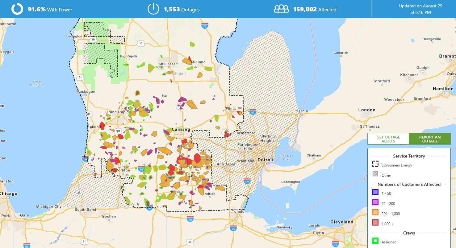
A squall line of severe thunderstorms produced widespread power outages across southern Lower Michigan, from the lakeshore all the way to metro Detroit. Peak statewide outages were around 650,000 at one point, making this one of the higher outage-producing severe weather events for the state. Peak outages for Consumers Energy were around 160,000 and peak outages for DTE were nearly half a million.
Photos & Video
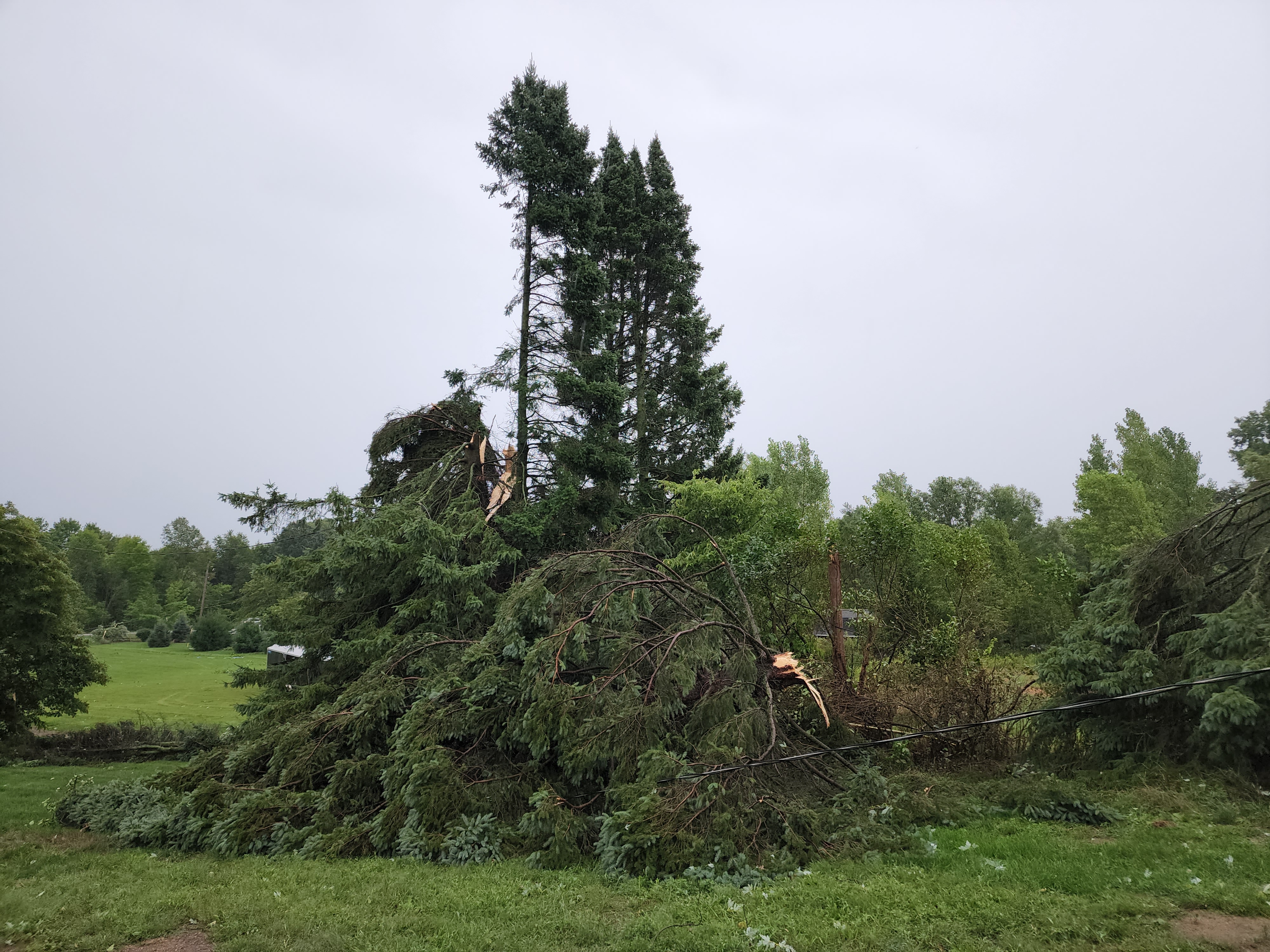
Below is a sampling of storm damage photos submitted by our partners in emergency management as well as our social media followers!
.jpg) |
 |
.jpg) |
.jpg) |
| Holland Shelia M. Smith |
Alto Kent County Emergency Management |
Plainwell Sarah J. Lyster |
Otsego Kylie Baker |
.jpg) |
.jpg) |
.jpg) |
|
| Battle Creek Jennifer Davis |
Portland Sadie Haglund |
Charlotte Alexandria Olson |
Radar
Here is a radar loop from approximately 1:30pm - 7:00pm on August 29, 2022:
Storm Reports
Follow Link for wind damage reports
Public Information Statement
National Weather Service Grand Rapids MI
751 AM EDT Tue Aug 30 2022

...HIGHEST WIND REPORTS...

Location                     Speed     Time/Date       Lat/Lon

...Michigan...

...Allegan County...
W Mich Regional Arpt         66 MPH    0308 PM 08/29   42.75N/86.10W
3.6 SE Allegan (MAWN)        50 MPH    0400 PM 08/29   42.49N/85.80W
Plainwell                    43 MPH    0410 PM 08/29   42.66N/85.65W
North Dorr                   41 MPH    0339 PM 08/29   42.76N/85.73W

...Calhoun County...
Battle Creek Executive Airpo 58 MPH    0414 PM 08/29   42.32N/85.23W
Marshall Brooks Field        49 MPH    0435 PM 08/29   42.23N/84.95W

...Clinton County...
Lansing                      51 MPH    0437 PM 08/29   42.78N/84.58W

...Gratiot County...
Alma                         40 MPH    0435 PM 08/29   43.32N/84.68W

...Ingham County...
Mason Jewett Arpt            52 MPH    0503 PM 08/29   42.57N/84.42W
1.8 S East Lansing (MAWN)    44 MPH    0500 PM 08/29   42.71N/84.48W

...Ionia County...
Ionia County Arpt            44 MPH    0415 PM 08/29   42.93N/85.07W
2.4 NW Clarksville (MAWN)    39 MPH    0400 PM 08/29   42.87N/85.26W

...Isabella County...
Mt Pleasant Muni Arpt        39 MPH    0415 PM 08/29   43.62N/84.73W

...Jackson County...
Jackson County-Reynolds Fiel 54 MPH    0502 PM 08/29   42.27N/84.47W

...Kalamazoo County...
Kzoo/battle Creek Intl Airpo 53 MPH    0355 PM 08/29   42.23N/85.55W
2.0 SE Cooper (MAWN)         44 MPH    0400 PM 08/29   42.35N/85.59W

...Kent County...
Gerald R Ford Intl           58 MPH    0342 PM 08/29   42.88N/85.52W
Grandville                   47 MPH    0335 PM 08/29   42.90N/85.74W
3.2 NW Comstock Park (MAWN)  41 MPH    0400 PM 08/29   43.07N/85.72W

...Montcalm County...
1.1 W Entrican (MAWN)        43 MPH    0400 PM 08/29   43.35N/85.18W

...Ottawa County...
Holland Harbor               63 MPH    0306 PM 08/29   42.77N/86.20W
Hudsonville                  56 MPH    0323 PM 08/29   42.80N/85.86W

...Van Buren County...
South Haven Rgnl Arpt        47 MPH    0315 PM 08/29   42.35N/86.25W
Lawton                       44 MPH    0346 PM 08/29   42.17N/85.82W
0.9 SE Lawton (MAWN)         40 MPH    0400 PM 08/29   42.16N/85.83W

...Maritime Stations...
St. Joseph Pier              49 MPH    0302 PM 08/29   42.12N/86.49W
South Haven                  43 MPH    0310 PM 08/29   42.40N/86.29W
2 W South Haven              40 MPH    0320 PM 08/29   42.40N/86.33W

Observations are collected from a variety of sources with varying
equipment and exposures. We thank all volunteer weather observers
for their dedication. Not all data listed are considered official.
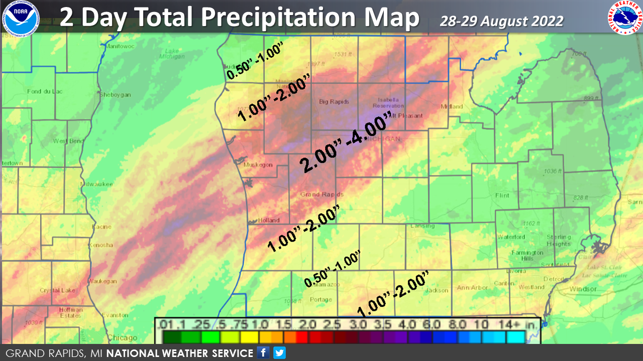
Rainfall Map
 |
Media use of NWS Web News Stories is encouraged! Please acknowledge the NWS as the source of any news information accessed from this site. |
|

