
Dangerous heat will expand from the Gulf Coast into the Southern Plains and Desert Southwest through week's end. Additional extreme heat impacting the Pacific Northwest will shift to the northern Plains by the weekend. Tropical Storm Bertha is expected to continue to impact portions of the northern Gulf Coast from the western Florida Panhandle to southeastern Louisiana through tonight. Read More >
Overview of the August 24, 2023 Tornadoes and Severe Weather Event
On August 24, 2023, severe thunderstorms formed over western Lower Michigan during the evening hours in the midst of an extremely unstable environment that also featured dew point readings (a measure of atmospheric moisture) around 80F, some of the highest we have seen over the last 60 years. These thunderstorms spawned two tornadoes in western Lower Michigan. The first tornado touched down in west central Kent County from Alpine Township to Plainfield Township, rated an EF-1 on a scale of 0 to 5 (with 5 being the most intense). The second tornado touched down in eastern Ingham County from Williamston to Webberville, before continuing on into Livingston County, and was rated an EF-2 in Ingham County before weakening to an EF-1 in Livingston County. In addition to the tornadoes, the thunderstorms produced numerous areas of 60 to 70 mph wind gusts and very high amounts of lightning. The combination of the tornadoes, strong wind gusts, and continuous lightning wiped out power to around 460,000 customers statewide at the height of the event.|
NWS Storm Survey |
Tornadoes:
|
Tornado #1 - Alpine & Plainfield Townships
Track Map 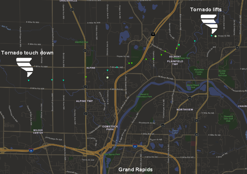 
|
||||||||||||||||
|
Tornado #2 - Williamston to Webberville
Track Map 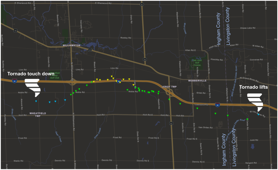
|
||||||||||||||||
The Enhanced Fujita (EF) Scale classifies tornadoes into the following categories:
| EF0 Weak 65-85 mph |
EF1 Moderate 86-110 mph |
EF2 Significant 111-135 mph |
EF3 Severe 136-165 mph |
EF4 Extreme 166-200 mph |
EF5 Catastrophic 200+ mph |
 |
|||||
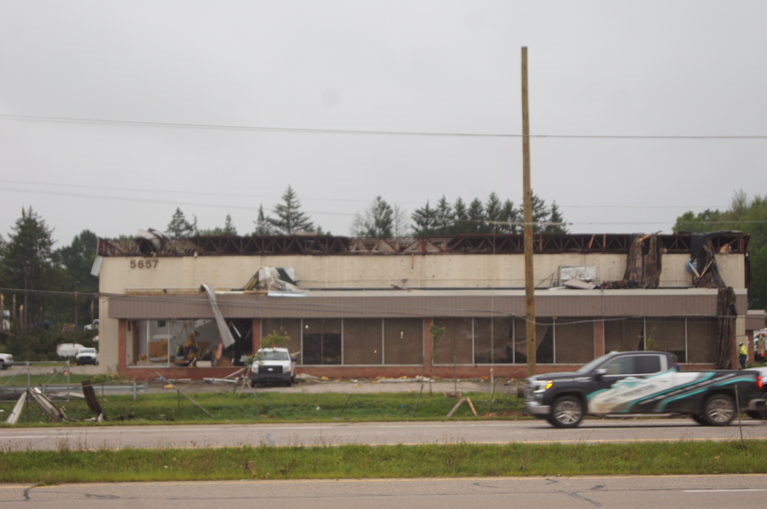
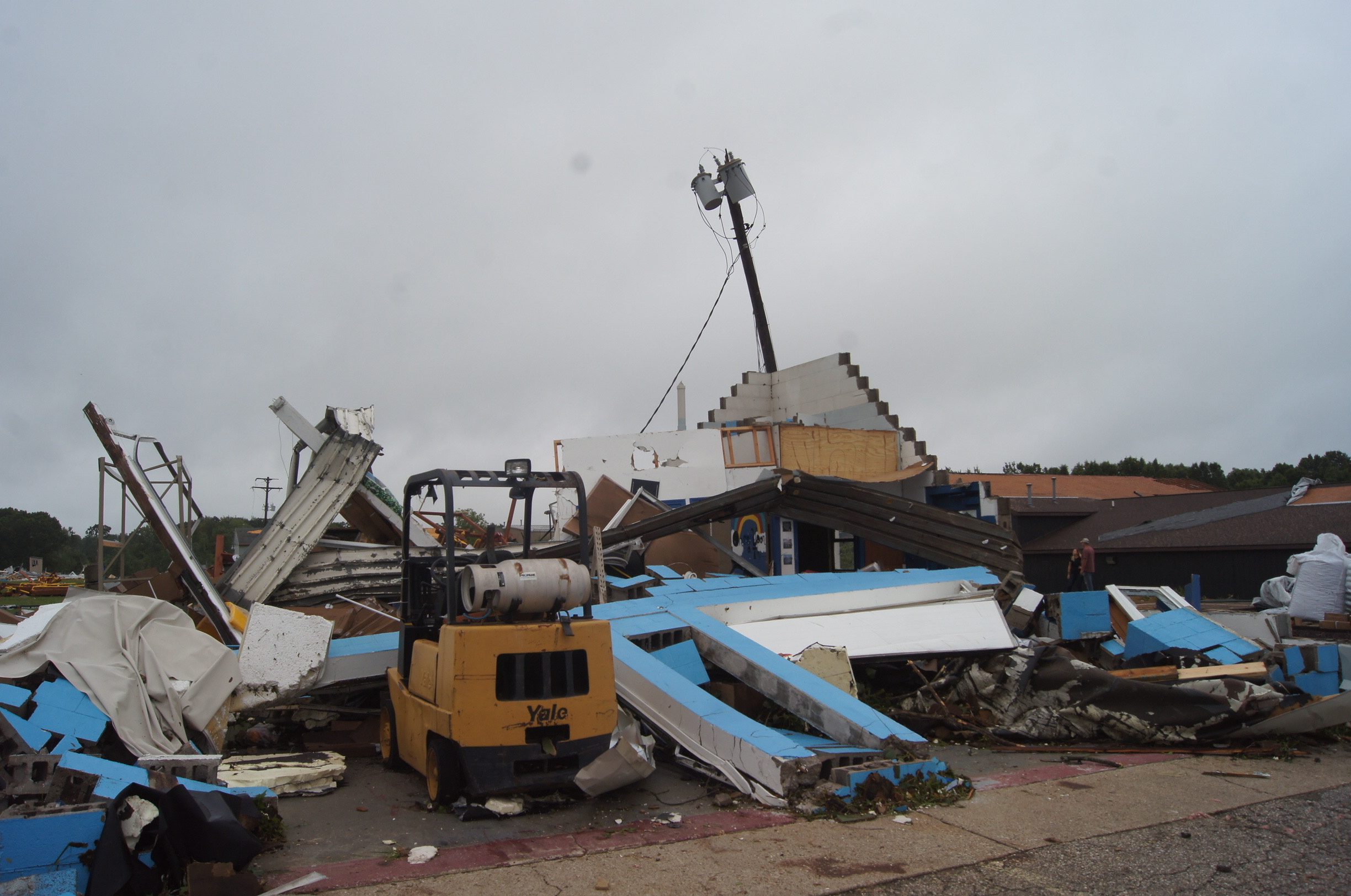
Photos & Video
 |
 |
 |
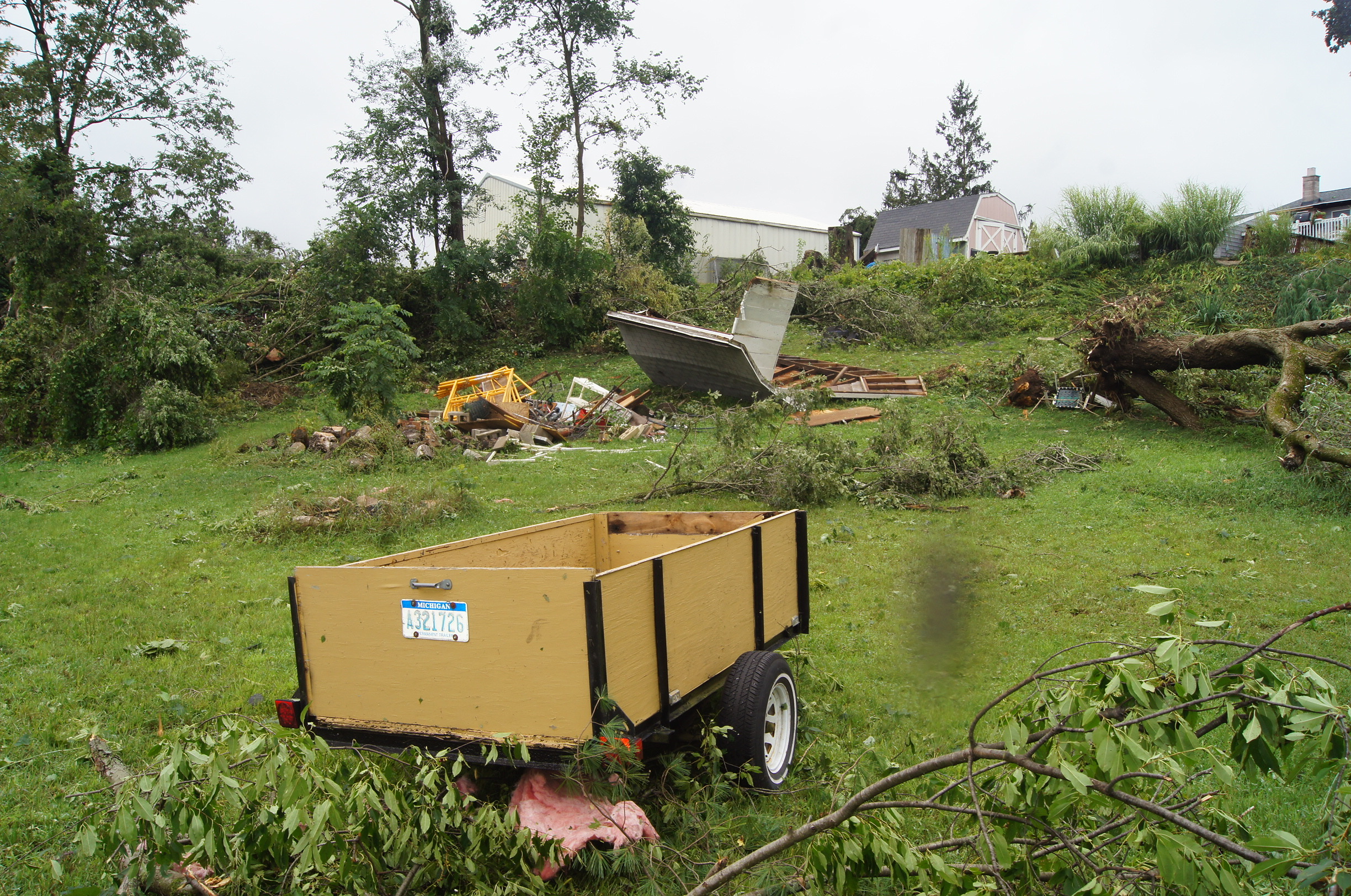 |
| Alpine Township, Kent County (NWS Storm Survey) |
Alpine Township, Kent County (NWS Storm Survey) |
Alpine Township, Kent County (NWS Storm Survey) |
Plainfield Township, Kent County (NWS Storm Survey) |
Aerial Videos
The Michigan State Police, Emergency Management & Homeland Security Division, has released numerous detailed videos taken by Michigan State Police helicopters surveying the tornado damage across Kent County and Ingham County. We encourage you to visit their YouTube page at:
https://www.youtube.com/@MichEMHS/videos
On this page, you'll be able to view extensive video documentation, including substantial footage of the EF-2 tornado damage path in eastern Ingham County.
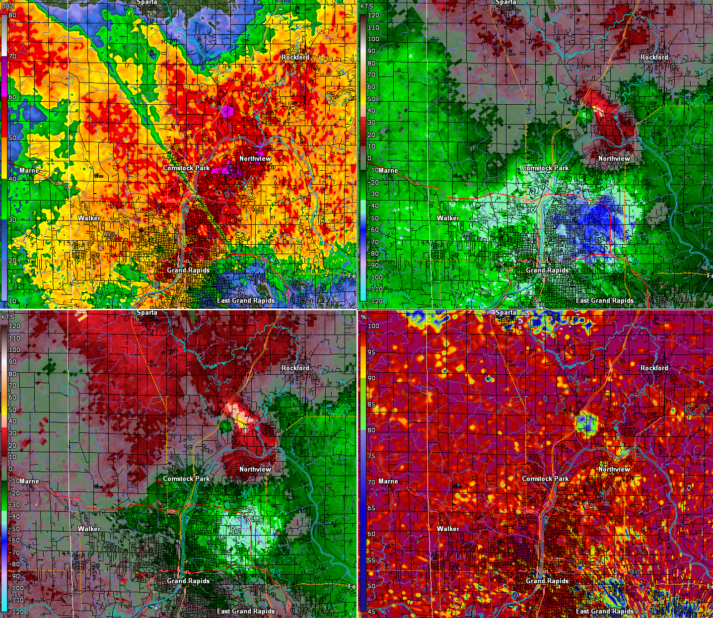
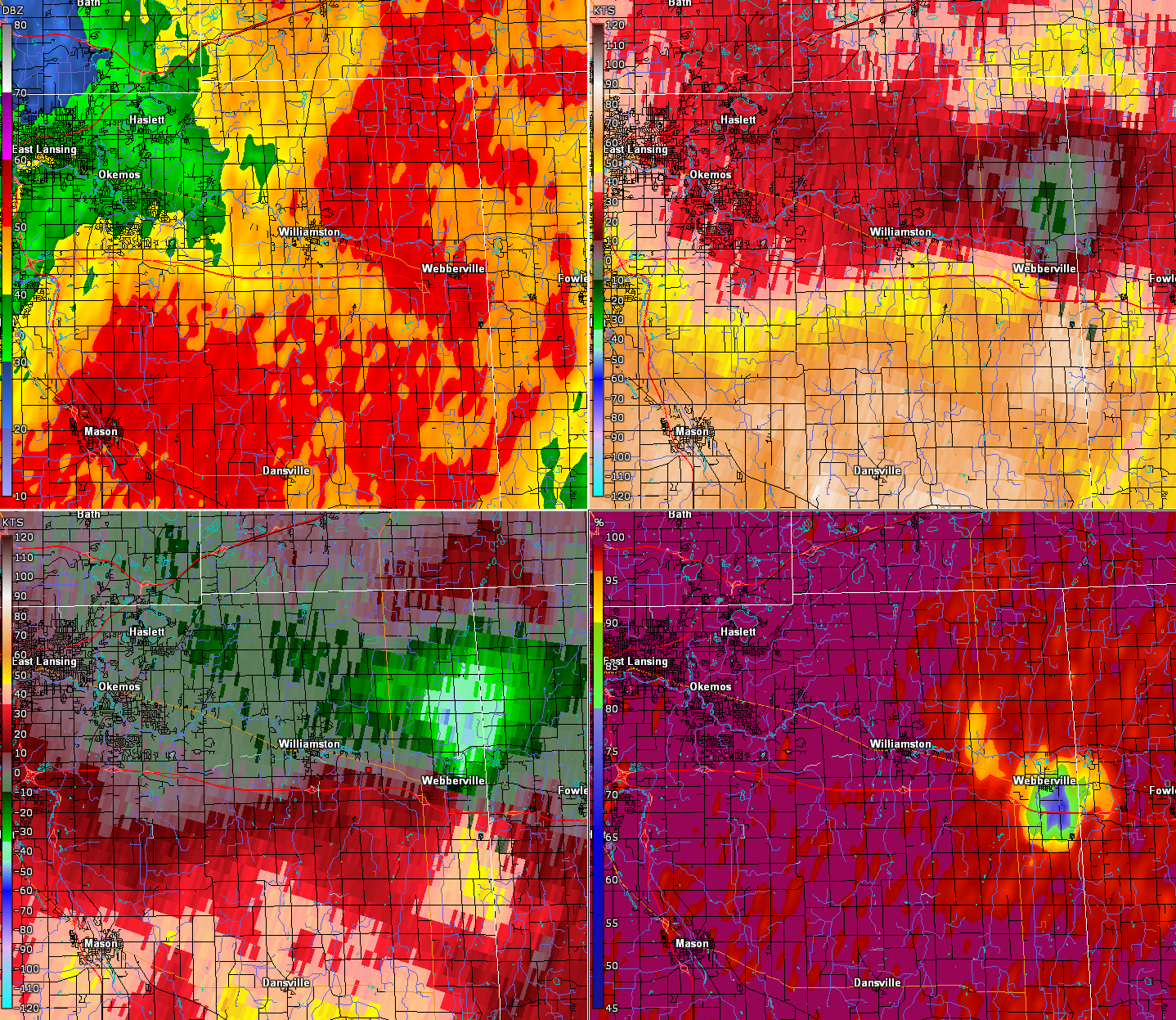
Radar
Radar Reflectivity for the evening of August 24th 2023
1. 4-panel imagery of Kent County tornado
8:20pm (Top Left - Reflectivity; Top Right - Base Velocity; Bottom Left - Storm Relative Velocity; Bottom Right - Correlation Coefficient)
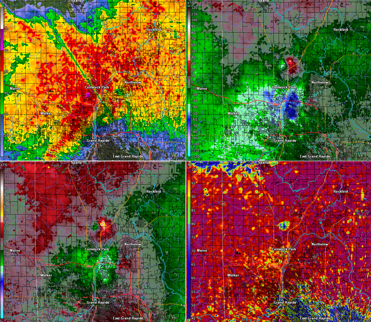
8:23pm (Top Left - Reflectivity; Top Right - Base Velocity; Bottom Left - Storm Relative Velocity; Bottom Right - Correlation Coefficient)
2. 4 panel imagery of Ingham County tornado
9:33pm (Top Left - Reflectivity; Top Right - Base Velocity; Bottom Left - Storm Relative Velocity; Bottom Right - Correlation Coefficient)
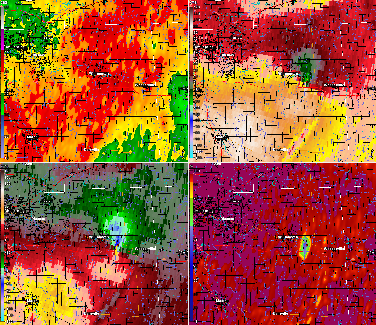
9:39pm (Top Left - Reflectivity; Top Right - Base Velocity; Bottom Left - Storm Relative Velocity; Bottom Right - Correlation Coefficient)
Storm Reports
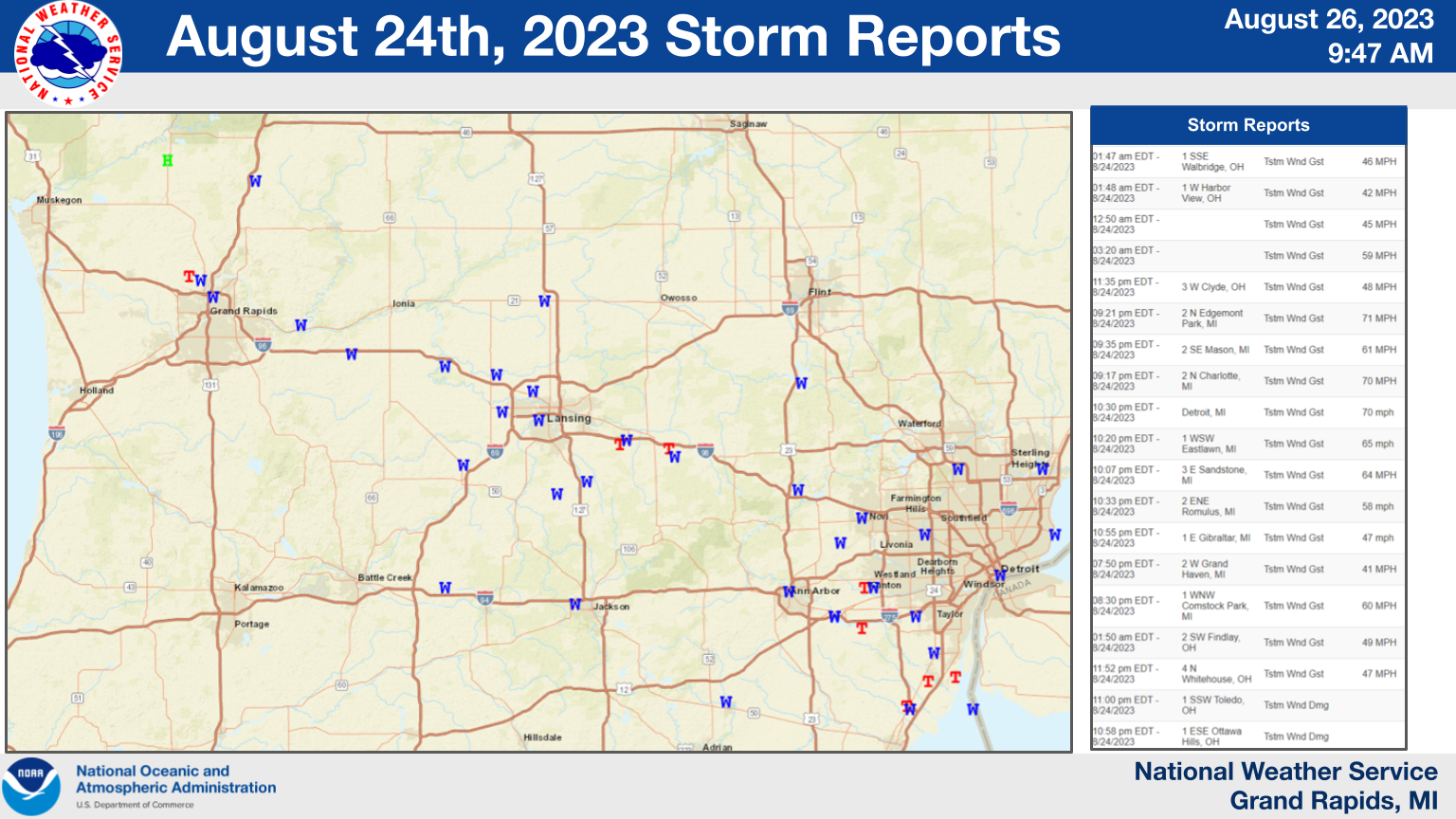
For more information go to : SPC August 24th, 2023 Damage Reports
Preliminary Local Storm Report...Summary
National Weather Service Grand Rapids MI
957 PM EDT Fri Aug 25 2023

..TIME...   ...EVENT...      ...CITY LOCATION...     ...LAT.LON...
..DATE...   ....MAG....      ..COUNTY LOCATION..ST.. ...SOURCE....
            ..REMARKS..

0921 PM     Tstm Wnd Gst     2 N Edgemont Park       42.78N 84.60W
08/24/2023  M71 MPH          Clinton            MI   ASOS


0917 PM     Tstm Wnd Gst     2 N Charlotte           42.60N 84.83W
08/24/2023  M70 MPH          Eaton              MI   Trained Spotter


1007 PM     Tstm Wnd Gst     3 E Sandstone           42.26N 84.46W
08/24/2023  M64 MPH          Jackson            MI   ASOS


0935 PM     Tstm Wnd Gst     2 SE Mason              42.56N 84.42W
08/24/2023  M61 MPH          Ingham             MI   ASOS


0830 PM     Tstm Wnd Gst     1 WNW Comstock Park     43.05N 85.70W
08/24/2023  E60 MPH          Kent               MI   Broadcast Media


0750 PM     Tstm Wnd Gst     2 W Grand Haven         43.05N 86.26W
08/24/2023  M41 MPH          LMZ846             MI   Mesonet


0745 PM     Hail             Grant                   43.34N 85.81W
08/24/2023  M1.00 inch       Newaygo            MI   Public

            Relayed by WZZM.

0803 PM     Tstm Wnd Dmg     Sand Lake               43.29N 85.52W
08/24/2023                   Kent               MI   Public

            Multiple large branches down. Time estimated
            via radar.

0815 PM     Tornado          4 WNW Comstock Park     43.06N 85.74W
08/24/2023                   Kent               MI   NWS Storm Survey

            Path Length 8.7 miles. Path Width 100 yards.
            Maximum Estimated windspeed 110 mph.

0817 PM     Tstm Wnd Dmg     3 SSE Comstock Park     43.01N 85.66W
08/24/2023                   Kent               MI   Broadcast Media

            Multiple large trees down. Time estimated
            via radar.

0818 PM     Tstm Wnd Dmg     2 NNW Comstock Park     43.07N 85.69W
08/24/2023                   Kent               MI   Trained Spotter

            Trees across M37 at 7 Mile. Possible
            tornado. Possible damage to structures. Time
            estimated from radar.

0820 PM     Tstm Wnd Dmg     2 W Belmont             43.07N 85.65W
08/24/2023                   Kent               MI   Broadcast Media

            Roof off of well built home. Camper flipped.
            Numerous homes with window and siding damage
            in Scotview Dr. Neighborhood. Possible
            Tornado. Time estimated via radar.

0821 PM     Tstm Wnd Dmg     2 WNW Belmont           43.08N 85.65W
08/24/2023                   Kent               MI   Emergency Mngr

            Tree on house. Possible tornado. Radar
            showed debris signature in this area.

0834 PM     Tstm Wnd Dmg     2 WNW Lowell            42.94N 85.37W
08/24/2023                   Kent               MI   Public

            Numerous trees down across Foreman St. Time
            estimated via radar.

0834 PM     Tstm Wnd Dmg     Lowell                  42.93N 85.35W
08/24/2023                   Kent               MI   Public

            Multiple trees down on Arrowhead Gold
            Course. Time estimated via radar.

0834 PM     Tstm Wnd Dmg     1 W Grattan             43.08N 85.41W
08/24/2023                   Kent               MI   Trained Spotter

            Tree down across Gavin Lake Road a few
            hundred feet south of M44. Time estimated
            from radar.

0835 PM     Tstm Wnd Dmg     5 SSE Grattan           43.01N 85.35W
08/24/2023                   Kent               MI   Public

            Multiple large trees down.

0835 PM     Tstm Wnd Dmg     5 SE Belmont            43.02N 85.56W
08/24/2023                   Kent               MI   NWS Employee

            Several large trees down.

0845 PM     Tstm Wnd Dmg     3 NE Clarksville        42.87N 85.20W
08/24/2023                   Ionia              MI   NWS Employee

            Over 30 pine trees down at Morrison Lake
            Golf Course. Time estimated via radar.

0850 PM     Tstm Wnd Dmg     2 SSE Portland          42.84N 84.89W
08/24/2023                   Ionia              MI   Public

            Multiple trees damaged between Peake Rd. and
            Butler Rd. Time estimated via radar.

0900 PM     Lightning        Holt                    42.64N 84.53W
08/24/2023                   Ingham             MI   Emergency Mngr

            County Emergency Management reports a house
            caught fire after being struck by lightning.
            Time estimated via radar.

0910 PM     Tstm Wnd Dmg     3 SE Grand Ledge        42.73N 84.70W
08/24/2023                   Eaton              MI   NWS Employee

            Large tree down across Nixon Rd. Numerous
            wires and large branches down. Time
            estimated via radar.

0910 PM     Tstm Wnd Dmg     Saint Johns             43.00N 84.56W
08/24/2023                   Clinton            MI   Public

            Numerous trees and limbs down in Saint
            Johns. Time estimated via radar.

0910 PM     Tstm Wnd Dmg     Grand Ledge             42.75N 84.75W
08/24/2023                   Eaton              MI   Local Official

            City of Grand Ledge reports numerous wires
            and trees down across the city. Time
            estimated via radar.

0910 PM     Tstm Wnd Dmg     Grand Ledge             42.76N 84.75W
08/24/2023                   Eaton              MI   NWS Employee

            Two to four inch limbs down.

0911 PM     Tstm Wnd Dmg     1 WSW Wacousta          42.82N 84.72W
08/24/2023                   Clinton            MI   Public

            Multiple trees and limbs down.

0912 PM     Tstm Wnd Dmg     Potterville             42.63N 84.75W
08/24/2023                   Eaton              MI   Public

            Trees and limbs down across Potterville.
            Time estimated via radar.

0915 PM     Tstm Wnd Dmg     1 NW Dimondale          42.66N 84.66W
08/24/2023                   Eaton              MI   Public

            Multiple trees uprooted onto homes in the
            Windsor Estates Mobile Home Park.

0915 PM     Tstm Wnd Dmg     1 W Lansing             42.71N 84.58W
08/24/2023                   Ingham             MI   Public

            Multiple large branches down in Colonial
            Village neighborhood. Time estimated via
            radar.

0915 PM     Tstm Wnd Dmg     1 NNW Waverly           42.75N 84.63W
08/24/2023                   Eaton              MI   Public

            Multiple 4 inch diameter healthy branches
            down. Time estimated via radar.

0922 PM     Tstm Wnd Dmg     Okemos                  42.71N 84.41W
08/24/2023                   Ingham             MI   Public

            Multiple large trees down in Okemos. Time
            estimated via radar.

0928 PM     Tstm Wnd Dmg     Aurelius                42.53N 84.52W
08/24/2023                   Ingham             MI   Public

            Several large trees down damaging a chicken
            coop. Time estimated via radar.

0935 PM     Tstm Wnd Dmg     Leslie                  42.45N 84.43W
08/24/2023                   Ingham             MI   Public

            Multiple trees and limbs down across Leslie.
            Time estimated via radar.

0935 PM     Tstm Wnd Dmg     2 S Williamston         42.66N 84.29W
08/24/2023                   Ingham             MI   Emergency Mngr

            Roof collapse of a building. Possible
            tornado.

0935 PM     Tstm Wnd Dmg     Williamston             42.69N 84.28W
08/24/2023                   Ingham             MI   Emergency Mngr

            Multiple cars flipped over on I-96. Possible
            tornado.

0940 PM     Tstm Wnd Dmg     3 NW Marengo            42.30N 84.89W
08/24/2023                   Calhoun            MI   Fire Dept/Rescue

            Marengo Twp. Fire reports multiple large
            trees down. Time estimated via radar.
 |
Media use of NWS Web News Stories is encouraged! Please acknowledge the NWS as the source of any news information accessed from this site. |
|


 Follow us on YouTube