
Dangerous heat will expand from the Gulf Coast into the Southern Plains and Desert Southwest through week's end. Additional extreme heat impacting the Pacific Northwest will shift to the northern Plains by the weekend. Tropical Storm Bertha is expected to continue to impact portions of the northern Gulf Coast from the western Florida Panhandle to southeastern Louisiana through tonight. Read More >
Overview
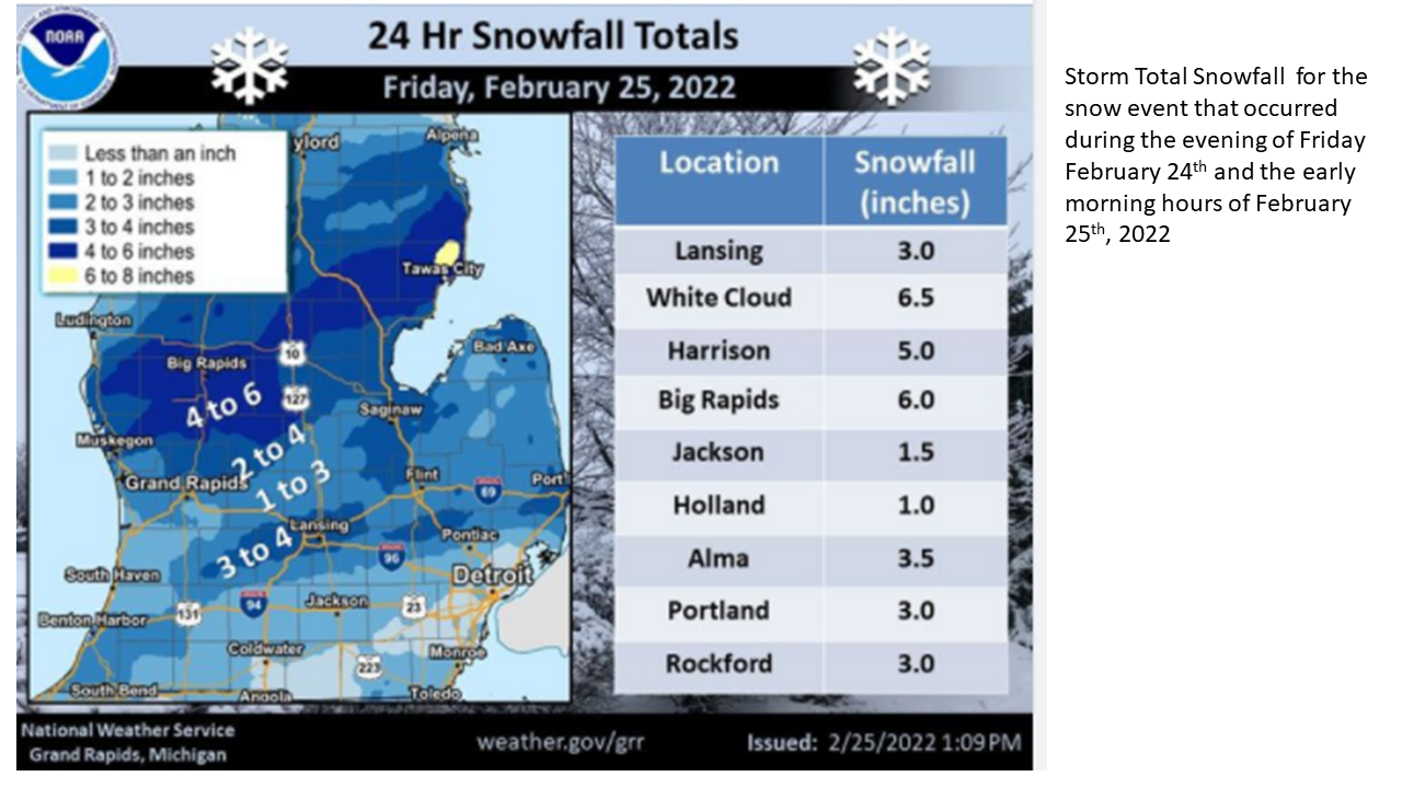
Snow began over southern and central Lower Michigan during the early evening hours of Friday, February 24th 2022 and continued into early morning hours of February 25th. The heaviest snowfall was between I-96 and Route 10, were 4 to 6 inches of snow fell. The surface low tracked northeast from Tennessee during the evening of the 24th into eastern Ohio by early in the morning on the 25th. Typically with a storm track that far south the heavy snow would have been south of Lower Michigan. However the 850 mb low .
Snow/Ice
Storm Reports
Public Information Statement
National Weather Service Grand Rapids MI
917 AM EST Fri Feb 25 2022

...OVERNIGHT SNOWFALL REPORTS...

Location                     Amount    Time/Date       Lat/Lon

...Michigan...

...Allegan County...
Plainwell 0.5 WSW            2.4 in    0800 AM 02/25   42.44N/85.65W
Otsego 0.9 WNW               2.0 in    0600 AM 02/25   42.46N/85.71W
Wayland 2.0 W                1.2 in    0700 AM 02/25   42.67N/85.68W

...Barry County...
Plainwell 5.4 E              3.8 in    0800 AM 02/25   42.45N/85.54W
Hastings                     2.5 in    0700 AM 02/25   42.65N/85.30W

...Calhoun County...
Springfield 0.6 WNW          1.5 in    0800 AM 02/25   42.33N/85.25W

...Clare County...
Harrison 5.2 ESE             5.2 in    0745 AM 02/25   43.99N/84.70W

...Clinton County...
Laingsburg 5.0 SW            3.5 in    0800 AM 02/25   42.84N/84.42W
Haslett 1.2 N                3.2 in    0700 AM 02/25   42.77N/84.40W
Saint Johns                  2.0 in    0733 AM 02/25   43.02N/84.55W

...Eaton County...
Lansing 4.7 NW               4.0 in    0700 AM 02/25   42.75N/84.62W
0.5 NE Eaton Rapids          2.0 in    0800 AM 02/25   42.52N/84.65W

...Ingham County...
Edgemont Park 0.7 NNE        3.4 in    0700 AM 02/25   42.76N/84.59W
Lansing 1.0 ENE              3.0 in    0800 AM 02/25   42.71N/84.53W

...Ionia County...
Saranac 2.6 NE               2.6 in    0640 AM 02/25   42.96N/85.17W
Ionia 3 W                    2.3 in    0700 AM 02/25   42.98N/85.12W

...Isabella County...
Mount Pleasant 1.4 NE        3.5 in    0700 AM 02/25   43.61N/84.76W

...Jackson County...
Jackson 3.2 W                1.5 in    0545 AM 02/25   42.24N/84.47W

...Kalamazoo County...
3 W Portage                  2.3 in    0800 AM 02/25   42.21N/85.66W
Portage 5.6 E                1.5 in    0800 AM 02/25   42.21N/85.48W

...Kent County...
Lowell 5.5 N                 3.0 in    0700 AM 02/25   43.01N/85.35W
Comstock Park 5.5 NNE        2.8 in    0800 AM 02/25   43.11N/85.62W
Belmont 1.0 WNW              2.8 in    0700 AM 02/25   43.08N/85.63W
Grand Rapids 2.5 ENE         2.5 in    0700 AM 02/25   42.97N/85.61W
Grand Rapids 2.9 NW          2.5 in    0700 AM 02/25   42.99N/85.69W
East Grand Rapids 0.7 SSW    2.4 in    0700 AM 02/25   42.94N/85.61W
Grandville 1.3 WSW           2.3 in    0700 AM 02/25   42.90N/85.78W
Lowell Wwtp                  2.2 in    0800 AM 02/25   42.93N/85.33W
Ada 0.7 SE                   2.2 in    0700 AM 02/25   42.95N/85.48W
Caledonia 4.4 WNW            2.1 in    0740 AM 02/25   42.83N/85.59W
Grand Rapids 3.0 NW          2.0 in    0730 AM 02/25   42.99N/85.69W

...Mecosta County...
Big Rapids 3.1 SE            6.0 in    0700 AM 02/25   43.68N/85.44W
Big Rapids 5.4 S             4.5 in    0700 AM 02/25   43.63N/85.48W

...Montcalm County...
Fenwick 3.3 E                3.0 in    0700 AM 02/25   43.15N/85.01W

...Newaygo County...
White Cloud 7.5 ENE          6.5 in    0700 AM 02/25   43.61N/85.64W

...Oceana County...
Hart 3 WSW                   3.7 in    0700 AM 02/25   43.67N/86.42W

...Ottawa County...
Holland 4.2 NW               2.0 in    0600 AM 02/25   42.82N/86.15W
Holland 4.3 NNW              1.5 in    0700 AM 02/25   42.82N/86.15W
Holland                      1.0 in    0700 AM 02/25   42.80N/86.12W

...Van Buren County...
Paw Paw 2.0 NE               2.0 in    0700 AM 02/25   42.24N/85.86W
Gobles 1.0 ESE               2.0 in    0854 AM 02/25   42.36N/85.86W
Paw Paw 3.6 NNE              2.0 in    0700 AM 02/25   42.27N/85.86W

Observations are collected from a variety of sources with varying
equipment and exposures. We thank all volunteer weather observers
for their dedication. Not all data listed are considered official.

$$

CAS
 |
Media use of NWS Web News Stories is encouraged! Please acknowledge the NWS as the source of any news information accessed from this site. |
|

