
Dangerous heat will expand from the Gulf Coast into the Southern Plains and Desert Southwest through week's end. Additional extreme heat impacting the Pacific Northwest will shift to the northern Plains by the weekend. Tropical Storm Bertha is expected to continue to impact portions of the northwestern Gulf Coast from south central Louisiana to the upper Texas coast today. Read More >
Overview
Two rounds of significant weather impacted southern Lower Michigan on Thursday, February 17th, 2022. The first round came as heavy rain Wednesday night and early Thursday morning, which combined with mild temperatures and melting snow lead to areas of flooding. The second round came as snow Thursday afternoon and night, with widespread 4-7 inch accumulations reported south and east of Grand Rapids.
Flooding
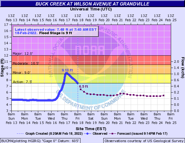
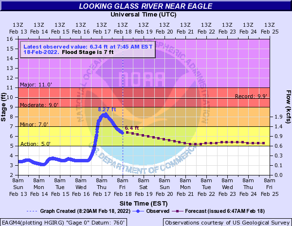
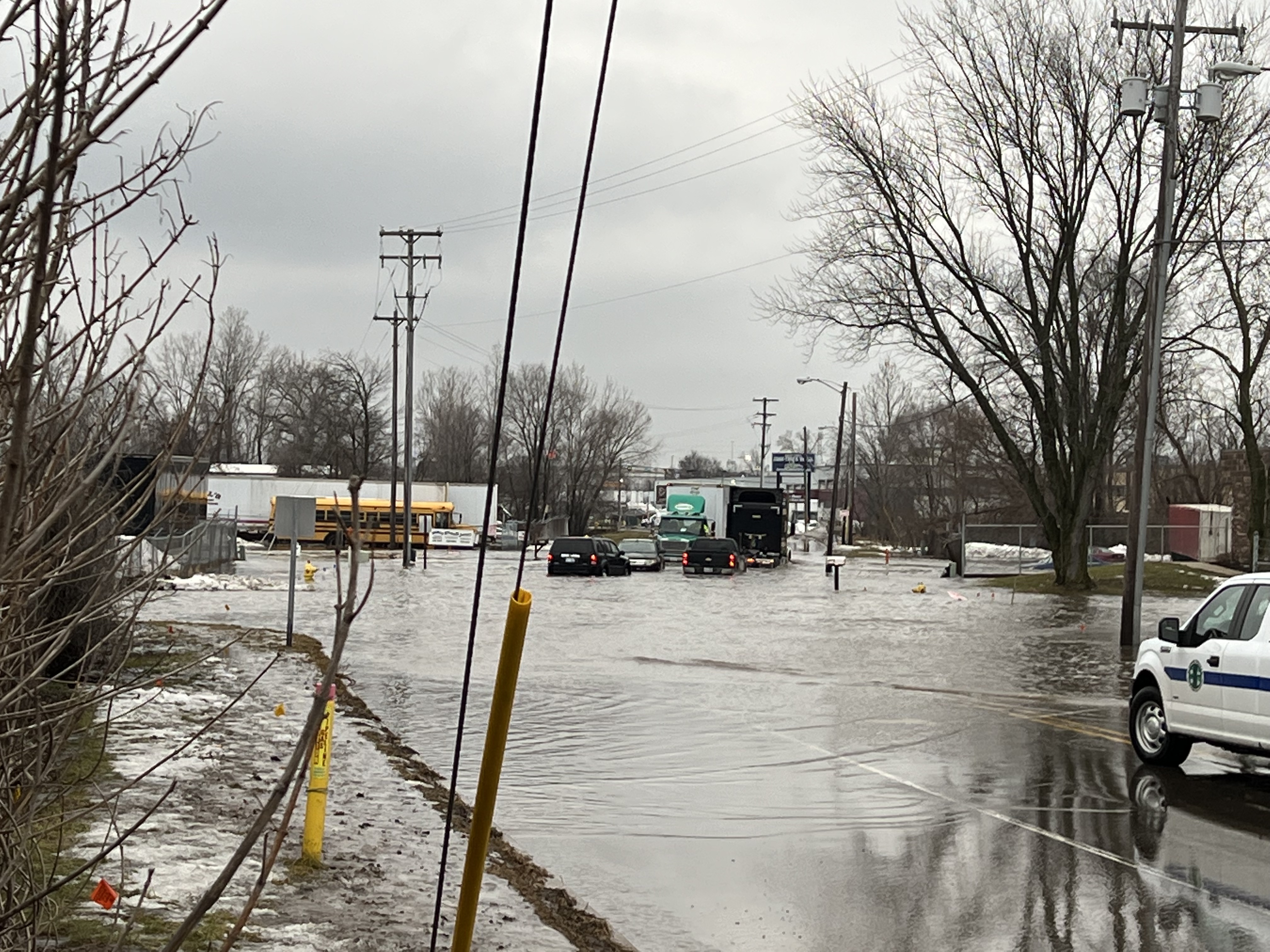
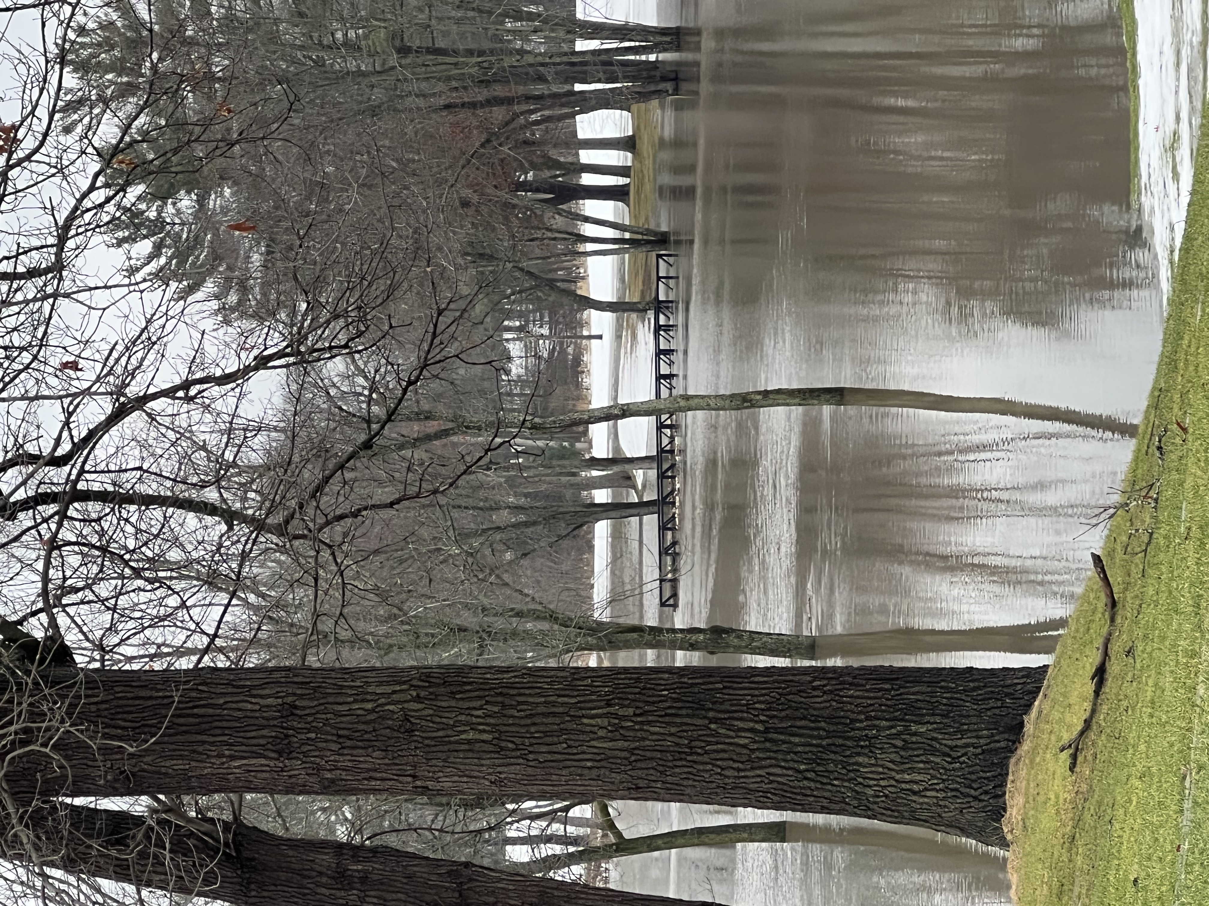
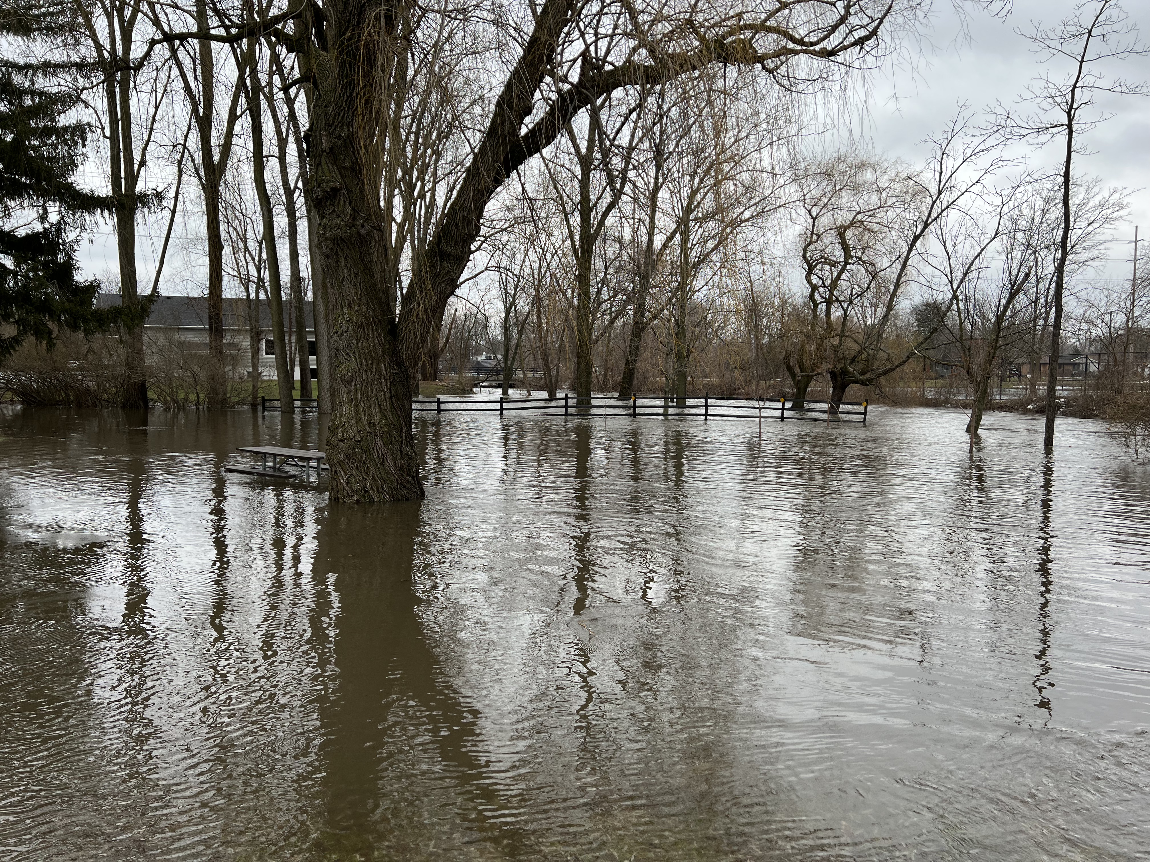
A few area river gauges are shown below, highlighting the abrupt rises that occurred due to the rapid runoff of rain and snowmelt over frozen ground around Grand Rapids and Lansing, MI. Photos show the high waters of Buck Creek in Wyoming and Grandville near Grand Rapids. (Photos are courtesy of Kent County Emergency Management.)
Hydrograph
 |
 |
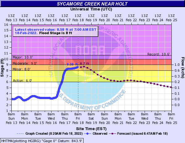 |
| Buck Creek in Grandville MI | Looking Glass River near Eagle MI | Sycamore Creek near Holt MI |
Photos
 |
 |
 |
| Clay Ave in Wyoming MI - Buck Creek |
Kaufman Golf Course in Wyoming MI - Buck Creek |
Wedgwood Park in Grandville - Buck Creek |
Observed Snowfall: Thursday Afternoon and Night, February 17-18, 2020
.png)
Storm Reports
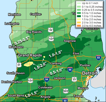
Heavy Rainfall Reports of Over One Inch, Ending 10 AM Thursday February 17th, 2020
Location                     Amount    Time/Date       Lat/Lon
Saranac 2.6 NE               1.73 in   0630 AM 02/17   42.96N/85.17W
Lowell 1.4 ESE               1.73 in   0700 AM 02/17   42.92N/85.32W
IOAM4                        1.66 in   0700 AM 02/17   42.98N/85.12W
Gerald R Ford Intl           1.66 in   0853 AM 02/17   42.88N/85.52W
Gitchel                      1.64 in   0700 AM 02/17   42.78N/85.85W
Byron Center                 1.59 in   0701 AM 02/17   42.82N/85.64W
2 NNW Caledonia              1.58 in   0600 AM 02/17   42.83N/85.53W
Saranac                      1.58 in   0707 AM 02/17   42.96N/85.20W
Caledonia 4.4 WNW            1.57 in   0700 AM 02/17   42.83N/85.59W
Caledonia                    1.50 in   0700 AM 02/17   42.83N/85.47W
1 WSW Kentwood               1.49 in   0600 AM 02/17   42.87N/85.62W
Otsego 0.9 WNW               1.48 in   0830 AM 02/17   42.46N/85.71W
Saugatuck 0.6 E              1.47 in   0700 AM 02/17   42.66N/86.19W
Hudsonville                  1.45 in   0705 AM 02/17   42.80N/85.86W
Allegan                      1.44 in   0700 AM 02/17   42.52N/85.77W
Gobles                       1.43 in   0707 AM 02/17   42.41N/85.91W
Grand Junction               1.39 in   0707 AM 02/17   42.68N/86.08W
Byron Center                 1.35 in   0700 AM 02/17   42.80N/85.65W
Dorr                         1.34 in   0833 AM 02/17   42.73N/85.72W
W Mich Regional Arpt         1.33 in   0653 AM 02/17   42.75N/86.10W
Ionia County Arpt            1.29 in   0655 AM 02/17   42.93N/85.07W
Grand Junction               1.27 in   0927 AM 02/17   42.68N/86.08W
Hastings                     1.25 in   0700 AM 02/17   42.65N/85.30W
Saint Johns                  1.25 in   0735 AM 02/17   43.02N/84.55W
Grand Junction 1 W           1.23 in   0600 AM 02/17   42.40N/86.10W
Plainwell 0.5 WSW            1.23 in   0700 AM 02/17   42.44N/85.65W
2.3 W Fennville              1.22 in   0600 AM 02/17   42.59N/86.15W
Gobles 1.0 ESE               1.22 in   0833 AM 02/17   42.36N/85.86W
Tompkins                     1.16 in   0708 AM 02/17   42.39N/84.55W
Ada 0.7 SE                   1.15 in   0700 AM 02/17   42.95N/85.48W
Grand Rapids 3.0 NW          1.15 in   0830 AM 02/17   42.99N/85.69W
Grandville                   1.14 in   0700 AM 02/17   42.90N/85.76W
Jamestown                    1.13 in   0701 AM 02/17   42.83N/85.83W
De Witt 1.2 W                1.12 in   0700 AM 02/17   42.83N/84.60W
Grand Junction               1.12 in   0700 AM 02/17   42.41N/86.05W
Lowell 5.5 NW                1.12 in   0800 AM 02/17   42.99N/85.42W
Hopkins                      1.10 in   0709 AM 02/17   42.59N/85.70W
Parma                        1.09 in   0927 AM 02/17   42.26N/84.60W
Croton                       1.08 in   0700 AM 02/17   43.39N/85.60W
Grand Junction 1 W           1.07 in   0900 AM 02/17   42.40N/86.10W
Croton                       1.07 in   0920 AM 02/17   43.39N/85.60W
Allegan                      1.05 in   0705 AM 02/17   42.53N/85.83W
Grandville 1.3 WSW           1.04 in   0700 AM 02/17   42.90N/85.78W
Grand Junction               1.04 in   0931 AM 02/17   42.41N/86.05W
North Dorr                   1.04 in   0938 AM 02/17   42.76N/85.73W
East Grand Rapids            1.03 in   0700 AM 02/17   42.94N/85.61W
Grand Rapids                 1.02 in   0705 AM 02/17   43.00N/85.66W
Rockford                     1.02 in   0935 AM 02/17   43.09N/85.57W
Holland 3.9 NNE              1.01 in   0600 AM 02/17   42.82N/86.07W

----------------------------------------------------------------------
Storm Total Snowfall Reports for Thursday Afternoon and Night, February 17-18, 2022
Location                     Amount    Time/Date       Lat/Lon

...Michigan...

...Allegan County...
Plainwell                    4.0 in    0934 AM 02/18   42.45N/85.64W
Allegan                      4.0 in    1032 AM 02/18   42.53N/85.84W
Dorr                         3.0 in    0900 AM 02/18   42.73N/85.72W
Otsego 0.9 WNW               2.5 in    0600 AM 02/18   42.46N/85.71W
Plainwell 0.5 WSW            2.2 in    0700 AM 02/18   42.44N/85.65W
Holland 5.3 WSW              2.2 in    0800 AM 02/18   42.75N/86.20W

...Barry County...
Hastings                     2.5 in    0700 AM 02/18   42.65N/85.30W
Plainwell 5.4 E              2.5 in    0800 AM 02/18   42.45N/85.54W

...Clare County...
Harrison 5.2 ESE             0.7 in    0700 AM 02/18   43.99N/84.70W

...Clinton County...
Haslett 1.2 N                4.1 in    0700 AM 02/18   42.77N/84.40W
2 NE Bath                    4.0 in    1048 PM 02/17   42.84N/84.42W
Laingsburg 5.0 SW            4.0 in    0700 AM 02/18   42.84N/84.42W
Saint Johns                  1.5 in    0733 AM 02/18   43.02N/84.55W

...Eaton County...
Lansing 4.7 NW               4.0 in    0700 AM 02/18   42.75N/84.62W
0.5 NE Eaton Rapids          3.7 in    0800 AM 02/18   42.52N/84.65W
1.3 NW Grand Ledge           2.0 in    0700 AM 02/18   42.77N/84.77W

...Ingham County...
East Lansing                 5.0 in    1032 AM 02/18   42.74N/84.48W
Edgemont Park 0.7 NNE        4.7 in    0700 AM 02/18   42.76N/84.59W
Lansing 2 WNW                4.3 in    1200 AM 02/18   42.75N/84.59W
1 E Haslett                  4.3 in    0804 AM 02/18   42.75N/84.38W
Okemos                       4.0 in    0530 AM 02/18   42.71N/84.41W
Williamston 4.0 ESE          4.0 in    0800 AM 02/18   42.66N/84.22W
2 E Okemos                   3.8 in    0700 AM 02/18   42.72N/84.36W
Lansing 1.0 ENE              3.8 in    0800 AM 02/18   42.71N/84.53W

...Ionia County...
Saranac 2.6 NE               2.3 in    0630 AM 02/18   42.96N/85.17W
Ionia 3 W                    1.3 in    0700 AM 02/18   42.98N/85.12W

...Isabella County...
4 SSE Shepherd               1.1 in    0600 AM 02/18   43.47N/84.67W

...Jackson County...
Jackson                      7.0 in    1030 AM 02/18   42.24N/84.41W
Jackson 3.2 W                6.0 in    0700 AM 02/18   42.24N/84.47W
3 SE Sandstone               6.0 in    0931 AM 02/18   42.23N/84.48W
Hanover 3.8 W                5.5 in    0739 AM 02/18   42.11N/84.63W
1 W Jackson                  3.5 in    0537 PM 02/17   42.24N/84.42W
Rives Junction               2.5 in    0530 PM 02/17   42.39N/84.45W

...Kalamazoo County...
1 WSW Eastwood               4.0 in    0857 AM 02/18   42.30N/85.56W
2 NW Portage                 4.0 in    0900 AM 02/18   42.22N/85.62W
Galesburg                    4.0 in    0933 AM 02/18   42.29N/85.42W
Comstock                     4.0 in    1029 AM 02/18   42.29N/85.51W
Richland                     4.0 in    1032 AM 02/18   42.38N/85.45W
Western Michigan University  3.5 in    1159 PM 02/17   42.28N/85.61W
3 W Portage                  3.5 in    0800 AM 02/18   42.21N/85.66W
Kalamazoo 5.6 E              3.0 in    0800 AM 02/18   42.27N/85.48W
1 N Kalamazoo                3.0 in    0858 AM 02/18   42.29N/85.59W
Portage 5.6 E                2.0 in    0800 AM 02/18   42.21N/85.48W

...Kent County...
Caledonia                    2.5 in    0854 AM 02/18   42.80N/85.51W
Grandville                   2.1 in    0700 AM 02/18   42.90N/85.77W
Grandville 1.3 WSW           2.1 in    0700 AM 02/18   42.90N/85.78W
Caledonia 4.4 WNW            2.0 in    0740 AM 02/18   42.83N/85.59W
Alto                         2.0 in    0930 AM 02/18   42.86N/85.38W
Ada 1.8 W                    1.9 in    0845 AM 02/18   42.95N/85.53W
1 SSW East Grand Rapids      1.7 in    0912 PM 02/17   42.94N/85.61W
East Grand Rapids 0.7 SSW    1.7 in    0700 AM 02/18   42.94N/85.61W
Comstock Park 5.5 NNE        1.7 in    0700 AM 02/18   43.11N/85.62W
East Grand Rapids            1.7 in    0700 AM 02/18   42.94N/85.61W
2 ENE Cascade                1.6 in    1130 PM 02/17   42.93N/85.46W
Grand Rapids 3.0 NW          1.6 in    0700 AM 02/18   42.99N/85.69W
Ada                          1.5 in    0858 AM 02/18   42.96N/85.49W
Belmont 1.0 WNW              1.4 in    0700 AM 02/18   43.08N/85.63W
Grand Rapids 2.9 NW          1.3 in    0700 AM 02/18   42.99N/85.69W
Grandville                   1.1 in    0700 AM 02/18   42.90N/85.76W
Ada 0.7 SE                   1.1 in    0700 AM 02/18   42.95N/85.48W
Lowell 5.5 N                 1.0 in    0700 AM 02/18   43.01N/85.35W
Sand Lake                    1.0 in    0856 AM 02/18   43.29N/85.52W
Lowell Wwtp                  0.8 in    0800 AM 02/18   42.93N/85.33W

...Mecosta County...
Big Rapids 3.1 SE            1.0 in    0700 AM 02/18   43.68N/85.44W
Big Rapids 5.4 S             0.8 in    0600 AM 02/18   43.63N/85.48W
Big Rapids Water Works       0.6 in    0700 AM 02/18   43.70N/85.48W

...Montcalm County...
Greenville                   1.0 in    0935 AM 02/18   43.18N/85.25W
Fenwick 3.3 E                0.2 in    0700 AM 02/18   43.15N/85.01W

...Muskegon County...
Fruitport                    0.5 in    0959 AM 02/18   43.13N/86.16W

...Newaygo County...
White Cloud 7.5 ENE          1.2 in    0700 AM 02/18   43.61N/85.64W
1.2 N Brunswick              0.4 in    0730 AM 02/18   43.45N/86.03W

...Oceana County...
Hart                         0.1 in    0700 AM 02/18   43.70N/86.37W
Hart 3 WSW                   0.1 in    0700 AM 02/18   43.67N/86.42W

...Ottawa County...
Jenison                      2.5 in    0855 AM 02/18   42.91N/85.83W
Holland 4.2 NW               2.0 in    0500 AM 02/18   42.82N/86.15W
Holland 3.9 NNE              1.8 in    0600 AM 02/18   42.82N/86.07W
Holland                      1.5 in    0700 AM 02/18   42.80N/86.12W
Holland                      1.5 in    1034 AM 02/18   42.77N/86.10W
Holland 4.3 NNW              0.8 in    0700 AM 02/18   42.82N/86.15W

...Van Buren County...
Paw Paw 3.6 NNE              3.2 in    0700 AM 02/18   42.27N/85.86W
Paw Paw 2.0 NE               2.9 in    0700 AM 02/18   42.24N/85.86W
Gobles 1.0 ESE               2.0 in    0857 AM 02/18   42.36N/85.86W


Observations are collected from a variety of sources with varying
equipment and exposures. We thank all volunteer weather observers
for their dedication. Not all data listed are considered official.
Observed Rainfall: Wednesday Night and Thursday Morning, February 16-17, 2020
 |
Media use of NWS Web News Stories is encouraged! Please acknowledge the NWS as the source of any news information accessed from this site. |
|

