
Record setting heat is expected over the next several days from the Intermountain West through the northern Plains. Furthermore, fire weather concerns increase with dry and breezy conditions. Meanwhile, heavy rainfall and severe thunderstorm threats for the Ohio/Tennessee Valleys, central Appalachians and Southeast today. The threat shifts to central Gulf Coast and across central Texas this week. Read More >
May 17-18, 2020 Widespread Flooding
 |
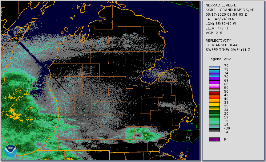 |
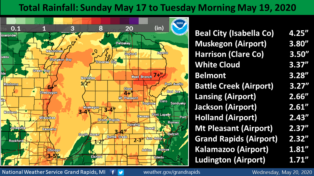
| Total accumulated rainfall from Sunday May 17 to Tuesday Morning May 19, 2020 | Radar animation from Sunday Morning to Monday Evening |
Significant rainfall fell across all of Lower Michigan on May 17 and 18 with many locations in Southwest Lower Michigan reporting over 3 inches of rain. This was the culmination of an already wet week that had experienced three separate episodes of heavy rain. As a result, soil was already saturated and this additional rain immediately became runoff instead of soaking into the ground.
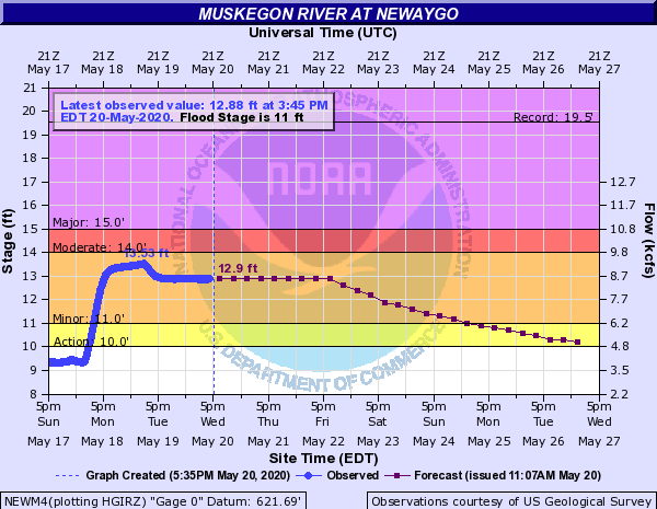
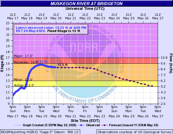
River Flooding
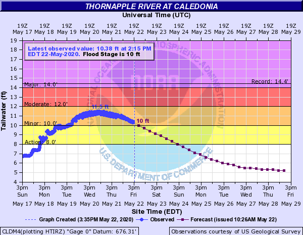
The Muskegon and Grand River Basins saw the brunt of the heaviest rain and were therefore impacted the most. This was particularly evident at Evart, near the uppermost reaches of the Muskegon River.
| Muskegon River | |
 |
 |
|
 |
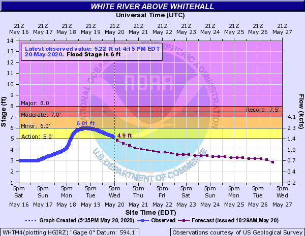 |
White River Basin: Slightly farther north, the White River also saw sharp rises that resulted in minor flooding. Lakeshore flooding also occurred in this area, resulting a temporary closure of the causeway (Dowling Street) that connects Whitehall and Montague.
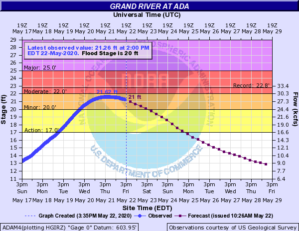
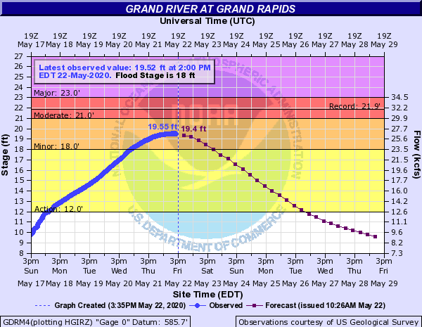
| Grand River | |
 |
 |
 |
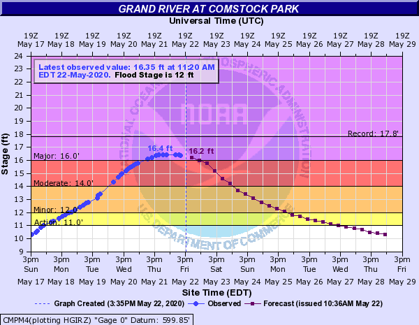 |
The lower reaches of the Grand River was in the procecss of cresting Friday night.
Previous Rainfall
 |
 |
 |
| Images courtesy of the Midwest Regional Climate Center | ||
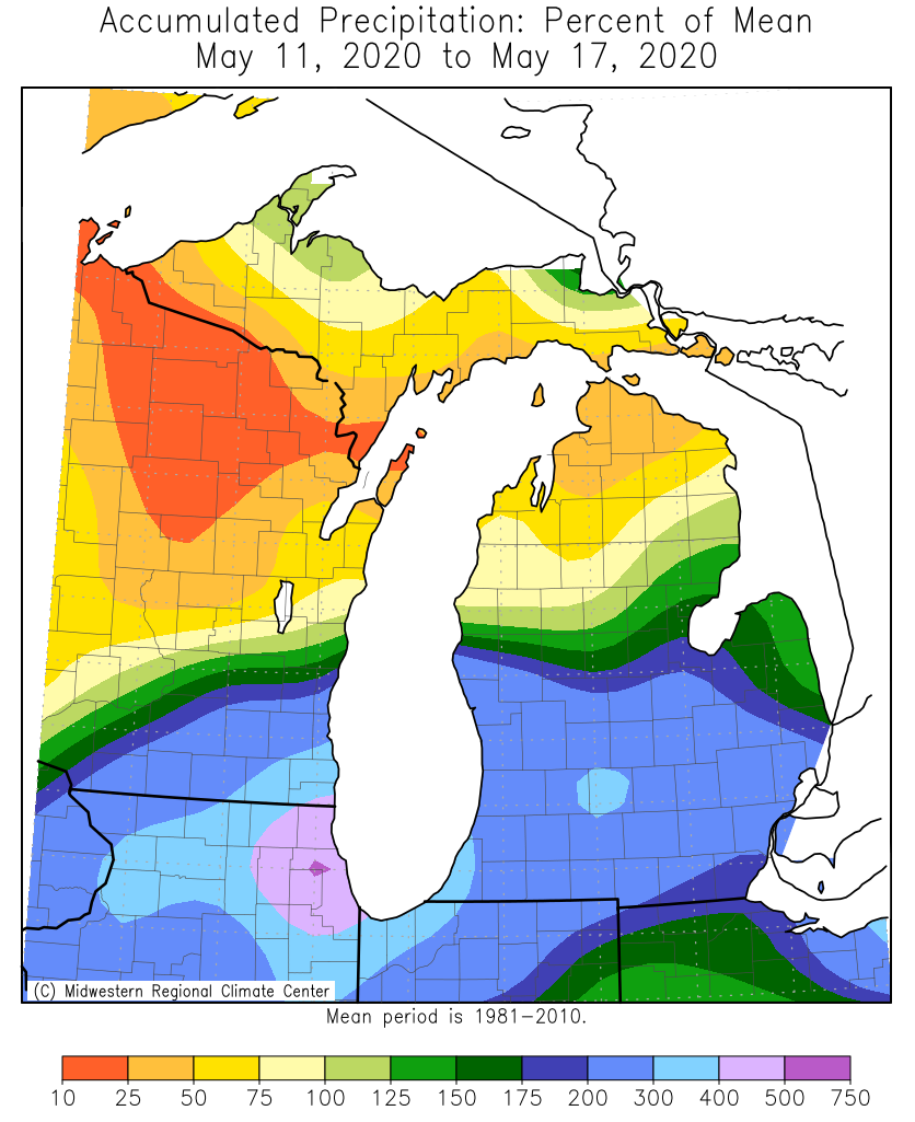
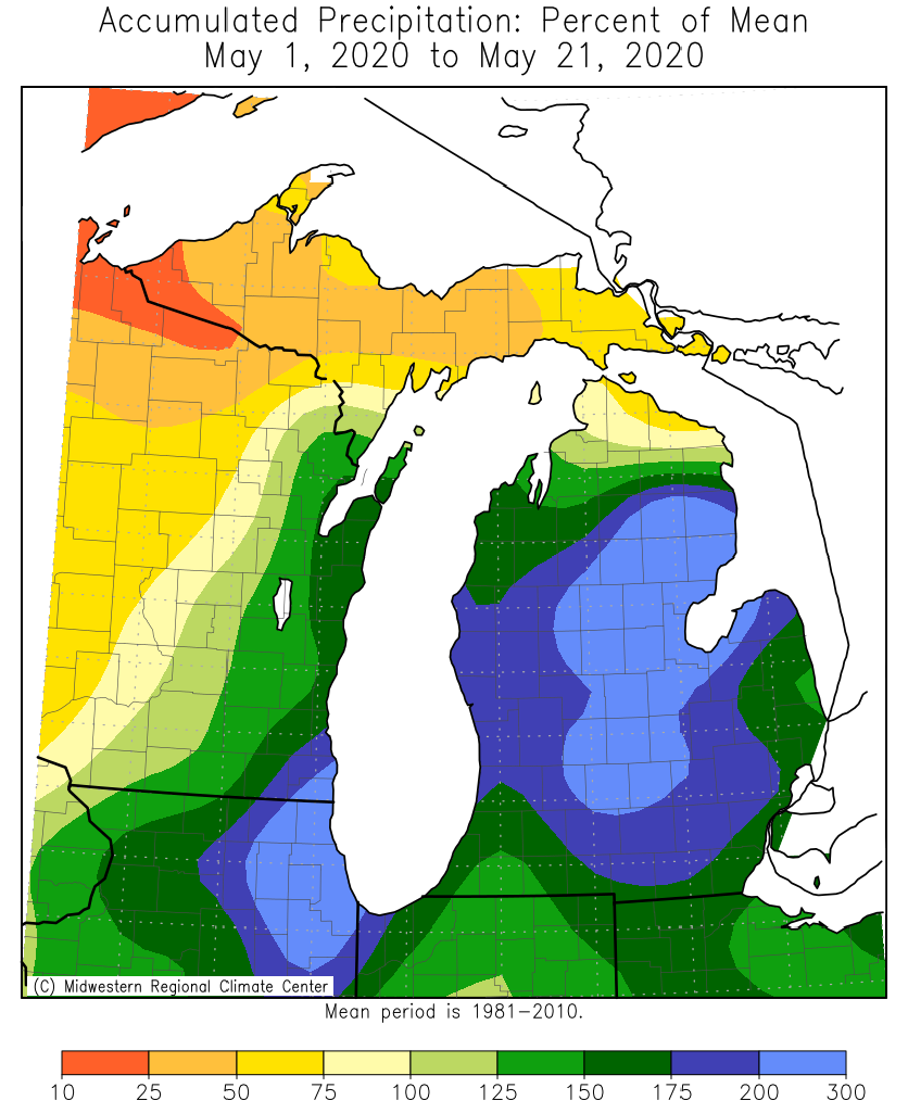
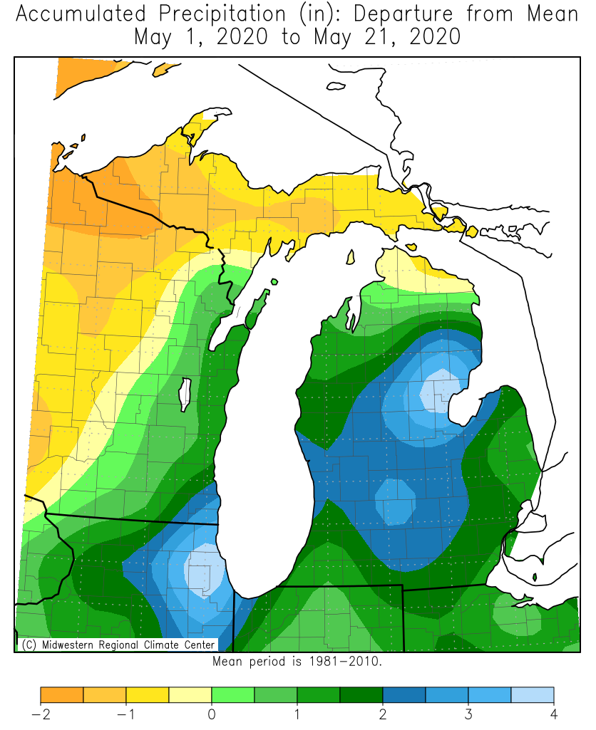
This was the third episode of heavy rain in a short period of time. The left graphic above shows that two to three times the normal amount of precipitation had fallen over the previous week. After this event, rainfall for the month of May stood around twice of what was normal.
Rainfall Reports
| Location | Amount (inches) | Time of Report | Latitude/Longitude |
| Beal City | 4.25 | 0300 PM 05/18 | 43.67N/84.91W |
| Shepherd | 3.89 | 0620 PM 05/18 | 43.47N/84.67W |
| 1 NE Norton Shores | 3.80 | 0956 AM 05/19 | 43.17N/86.24W |
| 4 SSW Nunica | 3.70 | 0350 PM 05/18 | 43.03N/86.11W |
| North Muskegon 1.9 NE | 3.53 | 0727 AM 05/19 | 43.27N/86.25W |
| Harrison | 3.50 | 0231 PM 05/18 | 44.02N/84.80W |
| 1 NNE White Cloud | 3.37 | 1145 AM 05/18 | 43.56N/85.77W |
| Norton Shores | 3.36 | 1100 AM 05/18 | 43.16N/86.25W |
| Muskegon 3.5 SSE | 3.32 | 0700 AM 05/19 | 43.18N/86.24W |
| Holland 4.2 NW | 3.30 | 0700 AM 05/19 | 42.82N/86.15W |
| Sunfield | 3.30 | 0730 AM 05/19 | 42.76N/84.99W |
| 2 WNW Belmont | 3.28 | 0700 AM 05/19 | 43.09N/85.64W |
| 1 SSW Springfield | 3.27 | 1003 AM 05/19 | 42.31N/85.24W |
| 1 S Hastings | 3.26 | 0700 AM 05/19 | 42.64N/85.29W |
| Trufant 1.8 SE | 3.20 | 0800 AM 05/19 | 43.29N/85.33W |
| 4 ENE Rockford | 3.20 | 0218 PM 05/18 | 43.14N/85.48W |
| Grandville | 3.09 | 0800 AM 05/19 | 42.90N/85.77W |
| Grandville 1.3 WSW | 3.09 | 0800 AM 05/19 | 42.90N/85.78W |
| Belmont 1.0 WNW | 3.07 | 0700 AM 05/19 | 43.08N/85.63W |
| Evart | 3.00 | 0613 AM 05/18 | 43.90N/85.25W |
| Hanover 4.1 E | 2.95 | 0900 AM 05/19 | 42.09N/84.47W |
| Leota | 2.93 | 0612 PM 05/18 | 44.12N/84.92W |
| 3 NNE Saint Louis | 2.92 | 0552 PM 05/18 | 43.45N/84.58W |
| Holland 4.3 NNW | 2.90 | 0700 AM 05/19 | 42.82N/86.15W |
| Battle Creek 11.7 NNW | 2.89 | 0700 AM 05/19 | 42.46N/85.29W |
| Grandville | 2.89 | 0700 AM 05/19 | 42.90N/85.76W |
| East Grand Rapids | 2.84 | 0700 AM 05/19 | 42.94N/85.61W |
| Cedar Springs 2.8 SSW | 2.80 | 0600 AM 05/19 | 43.18N/85.57W |
| Laingsburg 2.1 NNW | 2.79 | 0830 AM 05/19 | 42.92N/84.37W |
| Ada | 2.69 | 0954 AM 05/19 | 42.95N/85.49W |
| 2 N Edgemont Park | 2.66 | 1001 AM 05/19 | 42.78N/84.60W |
| Jackson 1.2 ENE | 2.64 | 0700 AM 05/19 | 42.25N/84.38W |
| Grand Rapids 4.6 ESE | 2.52 | 0800 AM 05/19 | 42.93N/85.58W |
| 2 ENE Cascade | 2.51 | 0205 PM 05/18 | 42.93N/85.46W |
| Mason 5.8 ENE | 2.51 | 0800 AM 05/19 | 42.61N/84.34W |
Observations are collected from a variety of sources with varying equipment and exposures. We thank all volunteer weather observers for their dedication. Not all data listed are considered official.
 |
Thank you to everyone who gave us permission to use their photos! Media use of NWS Web News Stories is encouraged! |
|
Page Last Updated: May 5th, 2020

