
Dangerous heat will expand from the Gulf Coast into the Southern Plains and Desert Southwest through week's end. Additional extreme heat impacting the Pacific Northwest will shift to the northern Plains by the weekend. Tropical Storm Bertha is expected to continue to impact portions of the northwestern Gulf Coast from south central Louisiana to the upper Texas coast today. Read More >
Overview
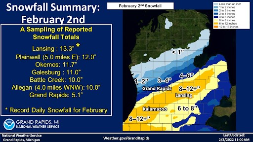
Record snowfall was observed over parts of Southwest Lower Michigan. Lansing set a new daily snowfall record for February with a reported total of 13.3 inches.
Snow/Ice
Storm Reports
Public Information Statement
National Weather Service Grand Rapids MI
503 PM EST Wed Feb 2 2022

...SNOWFALL REPORTS...

Location                     Amount    Time/Date       Lat/Lon

...Michigan...

...Allegan County...
5 NNE Bloomingdale           7.0 in    0116 PM 02/02   42.46N/85.94W
3 S Glenn                    6.5 in    1140 AM 02/02   42.48N/86.22W

...Barry County...
1 S Hastings                 8.8 in    0242 PM 02/02   42.64N/85.29W
2 WNW Delton                 7.5 in    0120 PM 02/02   42.51N/85.46W
5 SSW Irving                 6.0 in    1223 PM 02/02   42.62N/85.45W
Hastings                     4.5 in    1007 AM 02/02   42.65N/85.29W
Middleville                  3.0 in    1006 AM 02/02   42.72N/85.47W

...Calhoun County...
Battle Creek                 9.0 in    0354 PM 02/02   42.32N/85.18W
1 N Battle Creek             8.0 in    0100 PM 02/02   42.33N/85.18W
2 ENE Springfield            7.0 in    1230 PM 02/02   42.34N/85.21W
1 SE Brownlee Park           7.0 in    0225 PM 02/02   42.32N/85.12W

...Clinton County...
Bath                         8.0 in    0325 PM 02/02   42.82N/84.45W
Saint Johns                  6.5 in    0300 PM 02/02   43.00N/84.56W
1 SE Saint Johns             3.0 in    0925 AM 02/02   42.99N/84.55W

...Eaton County...
Dimondale                    9.0 in    0347 PM 02/02   42.65N/84.65W
Grand Ledge                  8.0 in    0125 PM 02/02   42.75N/84.75W
Olivet                       6.5 in    0230 PM 02/02   42.45N/84.92W
Charlotte                    4.0 in    1005 AM 02/02   42.57N/84.83W

...Ingham County...
1 WNW East Lansing           10.4 in   0450 PM 02/02   42.74N/84.51W
Lansing                      8.0 in    0138 PM 02/02   42.71N/84.55W
1 S Williamston              7.5 in    0315 PM 02/02   42.68N/84.28W
East Lansing                 6.5 in    1255 PM 02/02   42.74N/84.48W

...Ionia County...
3 S Portland                 7.0 in    0100 PM 02/02   42.83N/84.90W
3 S Portland                 4.0 in    1003 AM 02/02   42.83N/84.90W
2 NE Clarksville             2.0 in    0933 AM 02/02   42.86N/85.21W

...Jackson County...
Spring Arbor                 6.0 in    0300 PM 02/02   42.20N/84.56W
Rives Junction               4.3 in    1207 PM 02/02   42.39N/84.46W

...Kalamazoo County...
Kalamazoo                    7.0 in    0130 PM 02/02   42.27N/85.59W
Kalamazoo                    7.0 in    0147 PM 02/02   42.28N/85.59W
Vicksburg                    7.0 in    0358 PM 02/02   42.12N/85.53W
Galesburg                    5.5 in    1008 AM 02/02   42.29N/85.42W
Comstock                     5.5 in    1008 AM 02/02   42.29N/85.51W
Portage                      5.0 in    1004 AM 02/02   42.20N/85.59W
Kalamazoo                    4.3 in    0935 AM 02/02   42.28N/85.59W

...Kent County...
Alto                         5.0 in    0130 PM 02/02   42.86N/85.38W
2 SE Cutlerville             4.0 in    1215 PM 02/02   42.82N/85.64W
2 W Ada                      2.9 in    1205 PM 02/02   42.95N/85.53W
1 W Grattan                  2.5 in    0130 PM 02/02   43.08N/85.40W
Kentwood 4 ENE               0.4 in    0700 AM 02/02   42.89N/85.54W

...Muskegon County...
Muskegon 4 SE                0.3 in    0700 AM 02/02   43.18N/86.20W

...Ottawa County...
Jenison                      4.0 in    0457 PM 02/02   42.91N/85.83W

...Van Buren County...
Mattawan                     6.5 in    0100 PM 02/02   42.21N/85.79W

Observations are collected from a variety of sources with varying
equipment and exposures. We thank all volunteer weather observers
for their dedication. Not all data listed are considered official.
 |
Media use of NWS Web News Stories is encouraged! Please acknowledge the NWS as the source of any news information accessed from this site. |
|

