
Wildfire smoke continues to impact air quality from the Great Lakes region into New England and the Mid-Atlantic today with widespread Air Quality Alerts in effect. Severe thunderstorms are expected across portions of the Ohio Valley and Lower Great Lakes into the Mid-Atlantic and Northeast, this afternoon into the evening. Monsoonal thunderstorms may bring areas of flooding to the Southwest. Read More >
Overview
A robust mid-level cold pool led to the development of robust lake effect snow ahead of and behind an arctic front. Robust mixing behind the arctic front brought 30-40 mph gusts across much of West Michigan and 40-55 mph gusts to the lakeshore. In combination with very small flakes from the bitter cold, widespread blowing snow was reported with visibilities under 1 mile. Some lakeshore ASOSs saw drops to ¼ mile at times, with MKG seeing 3 hours of ¼ mile visbys, with only scattered winds reaching BZW criteria. Conditions west of US131 were treacherous Monday morning with a 100+ car pileup in southern Ottawa County on I-196.
Snow

Throughout this event there were periods of higher and more impactful snow. One of them was the night of Sunday January 18th to Tuesday morning January 20th, 2026. The snowfall map for that timeframe and amounts is below.

Radar
Bands of Snowfall that caused a 100 Car Pile up on I-196 Monday morning of January 19th, 2026
Radar Reflectivity
 |
 |
 |
 |
| 19 Jan 2026 Social Media post MDOT webcams along with NWS Radar |
19 Jan 2026 1015 AM Radar Reflectivity |
19 Jan 2026 7 AM Radar Reflectivity |
19 Jan 2026 9 AM Radar Reflectivity |
Web Cams and Media
Webcam and Traffic from January 19th, 2026
 |
 |
|
 |
| Social Media Post with MDOT traffic map and Webcams (MDOT) |
MDOT Traffic Map 11AM Jan 19, 2026 (MDOT) |
Caption (NWS Gra) |
Webcam of I-196 (MDOT) |
Headlines and Stories
Michigan State Police's Response to 100 Car Pile Up
Wind Reports
...HIGHEST WIND REPORTS THROUGH 420PM JAN 19 2026...

Location                     Speed     Time/Date       Lat/Lon

...Michigan...

...Allegan County...
I-196 Mile Marker 38.1       47 MPH    0503 AM 01/19   42.65N/86.19W
US-31 Mile Marker 47.0 Holla 47 MPH    0800 AM 01/19   42.75N/86.12W
W Mich Regional Arpt         43 MPH    1021 AM 01/19   42.75N/86.10W

...Calhoun County...
Battle Creek Executive Airpo 41 MPH    1142 AM 01/19   42.32N/85.23W
I-94 Mile Marker 108.3b Mars 40 MPH    0641 AM 01/19   42.30N/85.00W

...Clinton County...
Lansing                      43 MPH    1155 AM 01/19   42.78N/84.58W

...Gratiot County...
Alma                         40 MPH    0149 PM 01/19   43.32N/84.68W

...Ingham County...
Mason Jewett Arpt            41 MPH    1215 PM 01/19   42.57N/84.42W

...Isabella County...
B-3 M-20 At Costabella Ave   43 MPH    1206 PM 01/19   43.60N/85.09W
Mount Pleasant               40 MPH    1140 AM 01/19   43.59N/84.77W
Mt Pleasant Muni Arpt        40 MPH    1215 PM 01/19   43.62N/84.73W

...Jackson County...
Jackson County-Reynolds Fiel 43 MPH    1024 AM 01/19   42.27N/84.47W

...Mason County...
7 NW Ludington               55 MPH    0940 AM 01/19   44.05N/86.51W
Ludington                    46 MPH    0925 AM 01/19   43.95N/86.46W

...Mecosta County...
US-131 Mile Marker 138.7     40 MPH    1205 PM 01/19   43.69N/85.52W

...Muskegon County...
Muskegon County Airport      54 MPH    1128 AM 01/19   43.17N/86.23W
Whitehall                    50 MPH    0715 AM 01/19   43.37N/86.42W
Muskegon Pier                49 MPH    1030 AM 01/19   43.23N/86.34W

...Oceana County...
Shelby                       40 MPH    0725 AM 01/19   43.62N/86.54W

...Ottawa County...
Holland Harbor               47 MPH    0742 AM 01/19   42.77N/86.20W

...Van Buren County...
I94e-Mm0538                  42 MPH    0607 AM 01/19   42.19N/86.01W
I94w-Mm0477                  41 MPH    0517 AM 01/19   42.19N/86.13W
I94e-Mm0477                  41 MPH    0519 AM 01/19   42.19N/86.13W

...Maritime Stations...
Grand Haven Light            49 MPH    0637 AM 01/19   43.06N/86.26W

Observations are collected from a variety of sources with varying
equipment and exposures. We thank all volunteer weather observers
for their dedication. Not all data listed are considered official.

$$
Record Cold
Clipper systems continued to move through the Great Lakes region through the week, bringing gusty winds and perpetual snowfall, especially along the lakeshore. At the tail end of the event was an arctic air mass that dropped through the region Friday into Saturday morning. It is important to note that this was not the polar vortex, that was actually stable and situated around the north pole.
The Arctic airmass brought two rounds of extreme cold. The first was Friday morning. Low temperatures, near to just below zero, coupled with gusty winds to drop wind chills as low as -30. As high pressure built over the region, the winds slackened and the cold air settled to the surface Saturday morning. This brought low temperatures as low as -33F in Leota and -30 in Hersey. Record low temperatures were recorded across southwest Michigan Saturday morning.

Public Information Statement
National Weather Service Grand Rapids MI
947 AM EST Sat Jan 24 2026

...LOW TEMPERATURE REPORTS...

Location                     Temp      Time/Date       Lat/Lon

...Michigan...

...Allegan County...
Plainwell                    -22 F     0510 AM 01/24   42.66N/85.65W
Hopkins                      -22 F     0410 AM 01/24   42.64N/85.68W
Dorr                         -22 F     0525 AM 01/24   42.72N/85.78W
3.6 SE Allegan (MAWN)        -21 F     0430 AM 01/24   42.49N/85.80W
Allegan                      -20 F     0446 AM 01/24   42.52N/85.77W
WAYLAND                      -19 F     0530 AM 01/24   42.73N/85.65W
HOPKINS                      -19 F     0530 AM 01/24   42.65N/85.76W
W Mich Regional Arpt          -9 F     0353 AM 01/24   42.75N/86.10W
3 NNW Fennville               -6 F     0403 AM 01/24   42.65N/86.12W
2.6 W Fennville (MAWN)        -4 F     0540 AM 01/24   42.60N/86.16W
Holland                       -3 F     0451 AM 01/24   42.46N/86.11W

...Barry County...
2.6 W Dowling (MAWN)         -24 F     0545 AM 01/24   42.53N/85.30W
Hastings                     -23 F     0705 AM 01/24   42.60N/85.20W

...Calhoun County...
Marshall Brooks Field        -21 F     0815 AM 01/24   42.23N/84.95W
6.8 S Battle Creek (MAWN)    -21 F     0555 AM 01/24   42.22N/85.15W
Battle Creek Executive Airpo -18 F     0653 AM 01/24   42.32N/85.23W
1.4 NW Albion (MAWN)         -18 F     0525 AM 01/24   42.26N/84.77W
Albion Ag Mesonet            -17 F     0600 AM 01/24   42.26N/84.77W
Fulton                       -17 F     0835 AM 01/24   42.11N/85.26W
1 N Battle Creek             -15 F     0820 AM 01/24   42.34N/85.18W
Kellogg Community College    -14 F     0816 AM 01/24   42.34N/85.18W

...Clare County...
Leota                        -33 F     0804 AM 01/24   44.12N/84.92W
Marion                       -30 F     0815 AM 01/24   44.15N/84.98W
B-2 M115 At N River Road     -29 F     0759 AM 01/24   43.98N/85.08W
Harrison                     -17 F     0815 AM 01/24   43.94N/84.77W

...Clinton County...
Fowler                       -19 F     0515 AM 01/24   42.98N/84.72W
Haslett                      -14 F     0715 AM 01/24   42.77N/84.41W
Lansing                      -14 F     0653 AM 01/24   42.78N/84.58W

...Eaton County...
2 SW Kalamo                  -26 F     0805 AM 01/24   42.51N/85.03W
Grand Ledge                  -24 F     0735 AM 01/24   42.72N/84.82W
Charlotte Fitch Beach Arpt   -24 F     0655 AM 01/24   42.57N/84.82W
1.2 NW Gresham (MAWN)        -20 F     0600 AM 01/24   42.65N/84.92W

...Gratiot County...
Alma                         -17 F     0815 AM 01/24   43.32N/84.68W
Saint Louis                  -15 F     0810 AM 01/24   43.41N/84.61W
6.4 S Breckenridge (MAWN)    -12 F     0545 AM 01/24   43.32N/84.49W
St Louis                     -10 F     0840 AM 01/24   43.41N/84.61W

...Ingham County...
2.0 NW Leslie (MAWN)         -23 F     0600 AM 01/24   42.47N/84.46W
Leslie                       -21 F     0814 AM 01/24   42.52N/84.43W
3.2 NE Holt (MAWN)           -21 F     0800 AM 01/24   42.67N/84.49W
Mason Jewett Arpt            -20 F     0805 AM 01/24   42.57N/84.42W
East Lansing - 10m           -20 F     0820 AM 01/24   42.67N/84.49W
3.3 NE Holt                  -20 F     0800 AM 01/24   42.67N/84.48W
Okemos                       -18 F     0810 AM 01/24   42.71N/84.45W
Williamston                  -18 F     0815 AM 01/24   42.70N/84.28W
1 NW Okemos                  -17 F     0805 AM 01/24   42.73N/84.43W
Okemos                       -17 F     0845 AM 01/24   42.71N/84.45W
1.8 S East Lansing (MAWN)    -16 F     0735 AM 01/24   42.71N/84.48W
WILLIAMSTON                  -15 F     0815 AM 01/24   42.64N/84.33W
3.0 SW Shaftsburg (MAWN)     -14 F     0815 AM 01/24   42.77N/84.33W

...Ionia County...
BELDING                      -24 F     0811 AM 01/24   43.09N/85.24W
1 NNE Woodbury               -22 F     0630 AM 01/24   42.79N/85.07W
4.4 NW Smyrna (MAWN)         -22 F     0600 AM 01/24   43.11N/85.31W
Portland                     -21 F     0815 AM 01/24   42.90N/84.98W
Ionia 3 W                    -21 F     0700 AM 01/24   42.98N/85.12W
4.2 NW Smyrna                -20 F     0600 AM 01/24   43.11N/85.31W
2.4 NW Clarksville (MAWN)    -19 F     0640 AM 01/24   42.87N/85.26W
Ionia County Arpt            -18 F     0815 AM 01/24   42.93N/85.07W

...Isabella County...
M-20 At Costabella Ave       -21 F     0759 AM 01/24   43.60N/85.09W
Beal City                    -16 F     0835 AM 01/24   43.66N/84.91W
2 NW Shepherd                -14 F     0805 AM 01/24   43.56N/84.73W
1.4 S Mount Pleasant (MAWN)  -14 F     0825 AM 01/24   43.58N/84.77W
Shepherd                     -11 F     0850 AM 01/24   43.47N/84.67W
Mt Pleasant Muni Arpt        -11 F     0815 AM 01/24   43.62N/84.73W

...Jackson County...
Tompkins                     -25 F     0735 AM 01/24   42.39N/84.55W
Grass Lake                   -21 F     0810 AM 01/24   42.24N/84.25W
Parma                        -20 F     0812 AM 01/24   42.26N/84.60W
Jackson County-Reynolds Fiel -18 F     0756 AM 01/24   42.27N/84.47W
Spring Arbor                 -17 F     0830 AM 01/24   42.24N/84.50W
1 E Clark Lake               -16 F     0825 AM 01/24   42.12N/84.32W
Oak Point                    -15 F     0825 AM 01/24   42.19N/84.25W

...Kalamazoo County...
1.3 NE Midland Park (MAWN)   -22 F     0710 AM 01/24   42.41N/85.37W
2.0 SE Cooper (MAWN)         -22 F     0520 AM 01/24   42.35N/85.59W
Kalamazoo                    -20 F     0436 AM 01/24   42.27N/85.76W
Fulton                       -18 F     0650 AM 01/24   42.12N/85.37W
Kalamazoo/BC Intl Airport    -18 F     0553 AM 01/24   42.23N/85.55W
2 W Schoolcraft              -17 F     0515 AM 01/24   42.12N/85.68W

...Kent County...
Caledonia                    -26 F     0610 AM 01/24   42.83N/85.47W
Ada                          -24 F     0645 AM 01/24   42.98N/85.45W
Rockford                     -24 F     0715 AM 01/24   43.09N/85.47W
Miller-Sparta Airport        -22 F     0755 AM 01/24   43.13N/85.68W
Cedar Springs                -21 F     0815 AM 01/24   43.20N/85.59W
Lowell                       -21 F     0745 AM 01/24   43.03N/85.39W
3.2 NW Comstock Park (MAWN)  -20 F     0650 AM 01/24   43.07N/85.72W
Byron Center                 -19 F     0545 AM 01/24   42.82N/85.64W
Gerald R Ford Intl           -19 F     0634 AM 01/24   42.88N/85.52W
Grand Rapids                 -17 F     0530 AM 01/24   42.98N/85.74W
2.0 NW Sparta (MAWN)         -17 F     0820 AM 01/24   43.18N/85.74W
2.7 E Wright (MAWN)          -17 F     0700 AM 01/24   43.12N/85.76W
2.0 S Walker (MAWN)          -16 F     0445 AM 01/24   42.96N/85.75W
Kentwood                     -15 F     0546 AM 01/24   42.87N/85.64W
Walker                       -15 F     0656 AM 01/24   43.01N/85.68W
East Grand Rapids            -13 F     0705 AM 01/24   42.95N/85.61W
Grandville                   -13 F     0545 AM 01/24   42.90N/85.78W
1.3 NE Casnovia (MAWN)       -12 F     0340 AM 01/24   43.25N/85.77W

...Lake County...
Luther                       -25 F     0425 AM 01/24   44.11N/85.67W

...Mason County...
Custer                       -13 F     0645 AM 01/24   43.96N/86.22W
Ludington                     -3 F     0828 AM 01/24   43.96N/86.34W
4.8 SE Ludington (MAWN)       -1 F     0900 AM 01/24   43.90N/86.38W
Ludington Mason County Arpt    0 F     0855 AM 01/24   43.97N/86.40W
Commerce Township              1 F     0905 AM 01/24   44.07N/86.43W
Big Sable Point                3 F     0420 AM 01/24   44.05N/86.51W
7 NW Ludington                 4 F     0540 AM 01/24   44.05N/86.51W

...Mecosta County...
Big Rapids Roben-hood Arpt   -27 F     0715 AM 01/24   43.72N/85.50W
Big Rapids Water Works       -26 F     0700 AM 01/24   43.70N/85.48W
1.8 N Sylvester (MAWN)       -23 F     0600 AM 01/24   43.57N/85.24W

...Montcalm County...
Stanton                      -23 F     0825 AM 01/24   43.30N/85.07W
1.1 W Entrican (MAWN)        -22 F     0735 AM 01/24   43.35N/85.18W
3 S Lakeview                 -20 F     0805 AM 01/24   43.40N/85.28W
Greenville                   -20 F     0845 AM 01/24   43.18N/85.26W

...Muskegon County...
Muskegon County Airport       -7 F     0558 AM 01/24   43.17N/86.23W
Montague                      -6 F     0844 AM 01/24   43.42N/86.36W
Norton Shores                 -5 F     0705 AM 01/24   43.17N/86.22W
Whitehall                     -4 F     0455 AM 01/24   43.39N/86.33W
Muskegon Pier                 -4 F     0650 AM 01/24   43.23N/86.34W

...Newaygo County...
Grant                        -26 F     0725 AM 01/24   43.31N/85.76W
White Cloud                  -25 F     0215 AM 01/24   43.55N/85.76W
2.7 S Fremont (MAWN)         -25 F     0600 AM 01/24   43.42N/85.96W
Fremont Municipal Arpt       -24 F     0555 AM 01/24   43.43N/86.00W
1.9 W Grant (MAWN)           -24 F     0420 AM 01/24   43.33N/85.85W
SAND LAKE                    -22 F     0745 AM 01/24   43.33N/85.58W
Newaygo                      -22 F     0745 AM 01/24   43.41N/85.80W
Fremont                      -21 F     0605 AM 01/24   43.45N/85.94W
4 WNW Sand Lake              -19 F     0725 AM 01/24   43.33N/85.60W
1.4 NE Brunswick (MAWN)      -16 F     0645 AM 01/24   43.45N/86.03W
REED CITY                    -15 F     0712 AM 01/24   43.79N/85.62W
1.2 N Brunswick               -8 F     0730 AM 01/24   43.45N/86.03W

...Oceana County...
1.6 E Elbridge (MAWN)        -14 F     0520 AM 01/24   43.68N/86.19W
2 NE Shelby                   -9 F     0529 AM 01/24   43.64N/86.33W
1.2 SW Weare (MAWN)           -7 F     0535 AM 01/24   43.74N/86.36W
1.5 W New Era (MAWN)          -7 F     0605 AM 01/24   43.56N/86.38W
1.2 SW Weare                  -6 F     0800 AM 01/24   43.73N/86.35W
Mears (MAWN)                  -4 F     0425 AM 01/24   43.68N/86.41W
2.2 E Little Point Sable (MA  -3 F     0600 AM 01/24   43.63N/86.49W
Pentwater                     -2 F     0845 AM 01/24   43.81N/86.38W
Shelby                         0 F     0905 AM 01/24   43.62N/86.54W

...Osceola County...
Hersey                       -30 F     0817 AM 01/24   43.82N/85.41W
Sears                        -29 F     0825 AM 01/24   43.86N/85.15W
Reed City                    -29 F     0803 AM 01/24   43.89N/85.53W
Evart                        -28 F     0813 AM 01/24   43.90N/85.25W

...Ottawa County...
Gitchel                      -20 F     0510 AM 01/24   42.78N/85.85W
Jamestown                    -17 F     0500 AM 01/24   42.83N/85.83W
Jenison                      -15 F     0505 AM 01/24   42.90N/85.80W
Hudsonville                  -14 F     0445 AM 01/24   42.87N/85.87W
4.0 N Olive Center (MAWN)    -14 F     0415 AM 01/24   42.97N/86.08W
Allendale                    -13 F     0426 AM 01/24   42.98N/85.94W
1 SSW Allendale              -11 F     0415 AM 01/24   42.96N/85.97W
Zeeland                      -11 F     0505 AM 01/24   42.80N/86.00W
Spring Lake                  -10 F     0435 AM 01/24   43.05N/86.13W
Grand Haven                  -10 F     0428 AM 01/24   42.98N/86.10W
ALLENDALE                    -10 F     0405 AM 01/24   42.97N/85.89W
1.1 W Wright (MAWN)           -9 F     0535 AM 01/24   43.12N/85.83W
1 NE Spring Lake              -6 F     0708 AM 01/24   43.08N/86.18W
Holland Harbor                -1 F     0406 AM 01/24   42.77N/86.20W


...Van Buren County...
3.6 W Paw Paw (MAWN)         -19 F     0225 AM 01/24   42.21N/85.96W
Grand Junction (MAWN)        -15 F     0300 AM 01/24   42.40N/86.07W
Grand Junction 1 W           -14 F     0300 AM 01/24   42.40N/86.10W
0.9 SE Lawton (MAWN)         -13 F     0245 AM 01/24   42.16N/85.83W
1.6 NE Hartford (MAWN)       -11 F     0230 AM 01/24   42.23N/86.16W
Lawrence                      -9 F     0355 AM 01/24   42.23N/86.06W
Grand Junction                -9 F     0400 AM 01/24   42.41N/86.05W
2 SE Hartford                 -7 F     0345 AM 01/24   42.17N/86.13W
2.2 SW Hartford (MAWN)        -7 F     0300 AM 01/24   42.18N/86.18W
I94w-Mm0460                   -6 F     0333 AM 01/24   42.19N/86.17W
Hartford                      -5 F     0335 AM 01/24   42.17N/86.13W
3.1 S South Haven (MAWN)      -2 F     0655 AM 01/24   42.36N/86.29W
South Haven Rgnl Arpt          0 F     0855 AM 01/24   42.35N/86.25W

...Maritime Stations...
Grand Haven Light             -2 F     0650 AM 01/24   43.06N/86.26W
South Haven                   -1 F     0820 AM 01/24   42.40N/86.29W

Observations are collected from a variety of sources with varying
equipment and exposures. We thank all volunteer weather observers
for their dedication. Not all data listed are considered official.
Public Information Statement
National Weather Service Grand Rapids MI
832 AM EST Fri Jan 23 2026

...MINIMUM WIND CHILL REPORTS...

Location                     WC Temp.  Time/Date       Lat/Lon
3 S Lakeview                 -30 F     0650 AM 01/23   43.40N/85.28W
4 WNW Sand Lake              -27 F     0620 AM 01/23   43.33N/85.60W
Shelby                       -27 F     0730 AM 01/23   43.62N/86.54W
Ludington                    -27 F     0735 AM 01/23   43.95N/86.46W
US-131 Mile Marker 138.7     -27 F     0513 AM 01/23   43.69N/85.52W
2 NE Shelby                  -26 F     0719 AM 01/23   43.64N/86.33W
Whitehall                    -26 F     0545 AM 01/23   43.37N/86.42W
Alma                         -26 F     0716 AM 01/23   43.32N/84.68W
Gerald R Ford Intl           -26 F     0713 AM 01/23   42.88N/85.52W
Ionia County Arpt            -26 F     0815 AM 01/23   42.93N/85.07W
B-3 M-20 At Costabella Ave   -26 F     0723 AM 01/23   43.60N/85.09W
US 31 Mile Marker 140.7      -26 F     0656 AM 01/23   43.56N/86.39W
2 NW Shepherd                -25 F     0635 AM 01/23   43.56N/84.73W
1 NNE Woodbury               -25 F     0815 AM 01/23   42.79N/85.07W
Alma                         -25 F     0655 AM 01/23   43.32N/84.68W
Fremont Municipal Arpt       -25 F     0555 AM 01/23   43.43N/86.00W
Big Rapids Roben-hood Arpt   -25 F     0715 AM 01/23   43.72N/85.50W
I-96 Mile Marker 52.2        -25 F     0724 AM 01/23   42.88N/85.37W
1.8 N Sylvester (MAWN)       -25 F     0600 AM 01/23   43.57N/85.24W
2.7 E Wright (MAWN)          -25 F     0625 AM 01/23   43.12N/85.76W
Grand Haven Light            -25 F     0615 AM 01/23   43.06N/86.26W
1 SSW Allendale              -24 F     0700 AM 01/23   42.96N/85.97W
Cedar Springs                -24 F     0625 AM 01/23   43.20N/85.59W
Portland                     -24 F     0725 AM 01/23   42.90N/84.98W
Ludington Mason County Arpt  -24 F     0815 AM 01/23   43.97N/86.40W
Muskegon County Airport      -24 F     0548 AM 01/23   43.17N/86.23W
Reed City                    -24 F     0646 AM 01/23   43.89N/85.53W
M-46 Mile Marker 71.1        -24 F     0637 AM 01/23   43.41N/85.08W
M-20 Mile Marker 16.6        -24 F     0519 AM 01/23   43.57N/86.07W
2.2 E Little Point Sable (MA -24 F     0500 AM 01/23   43.63N/86.49W
Saint Louis                  -23 F     0705 AM 01/23   43.41N/84.61W
Custer                       -23 F     0655 AM 01/23   43.96N/86.22W
Grand Haven                  -23 F     0635 AM 01/23   43.00N/86.10W
Hastings                     -23 F     0755 AM 01/23   42.66N/85.34W
ALLENDALE                    -23 F     0630 AM 01/23   42.97N/85.89W
Lansing                      -23 F     0753 AM 01/23   42.78N/84.58W
Ludington                    -23 F     0518 AM 01/23   43.95N/86.44W
Ludington                    -23 F     0652 AM 01/23   43.96N/86.34W
US-131 Mile Marker 94.6      -23 F     0627 AM 01/23   43.09N/85.63W
I-96 Mile Marker 45.7        -23 F     0659 AM 01/23   42.89N/85.49W
M-6 Mile Marker 12.7         -23 F     0718 AM 01/23   42.85N/85.58W
1.1 W Wright (MAWN)          -23 F     0800 AM 01/23   43.12N/85.83W
1.1 W Entrican (MAWN)        -23 F     0600 AM 01/23   43.35N/85.18W
1.2 SW Weare (MAWN)          -23 F     0600 AM 01/23   43.74N/86.36W
Mears (MAWN)                 -23 F     0800 AM 01/23   43.68N/86.41W
Hopkins                      -22 F     0710 AM 01/23   42.64N/85.68W
Pentwater                    -22 F     0505 AM 01/23   43.73N/86.47W
Jenison                      -22 F     0715 AM 01/23   42.90N/85.80W
Fowler                       -22 F     0815 AM 01/23   42.98N/84.72W
Fremont                      -22 F     0710 AM 01/23   43.45N/85.94W
GRAND HAVEN                  -22 F     0615 AM 01/23   43.06N/86.25W
Holland Harbor               -22 F     0754 AM 01/23   42.77N/86.20W
1.6 E Elbridge (MAWN)        -22 F     0500 AM 01/23   43.68N/86.19W
1.4 NE Brunswick (MAWN)      -22 F     0600 AM 01/23   43.45N/86.03W
2 WNW Kentwood               -21 F     0730 AM 01/23   42.90N/85.63W
Battle Creek Executive Airpo -21 F     0751 AM 01/23   42.32N/85.23W
Charlotte Fitch Beach Arpt   -21 F     0815 AM 01/23   42.57N/84.82W
4.4 NW Smyrna (MAWN)         -21 F     0600 AM 01/23   43.11N/85.31W
2.4 NW Clarksville (MAWN)    -21 F     0800 AM 01/23   42.87N/85.26W
2.7 S Fremont (MAWN)         -21 F     0600 AM 01/23   43.42N/85.96W
1.4 NE New Era (MAWN)        -21 F     0600 AM 01/23   43.58N/86.33W
2.0 NW Sparta (MAWN)         -21 F     0800 AM 01/23   43.18N/85.74W
2 SW Kalamo                  -20 F     0805 AM 01/23   42.51N/85.03W
East Grand Rapids            -20 F     0650 AM 01/23   42.95N/85.61W
Leslie                       -20 F     0817 AM 01/23   42.52N/84.43W
Walker                       -20 F     0646 AM 01/23   43.01N/85.68W
Marion                       -20 F     0655 AM 01/23   44.15N/84.98W
Montague                     -20 F     0813 AM 01/23   43.42N/86.36W
Pentwater                    -20 F     0530 AM 01/23   43.78N/86.43W
Shepherd                     -20 F     0720 AM 01/23   43.47N/84.67W
Grand Haven                  -20 F     0633 AM 01/23   42.98N/86.10W
Miller-Sparta Airport        -20 F     0635 AM 01/23   43.13N/85.68W
3.2 NW Comstock Park (MAWN)  -20 F     0800 AM 01/23   43.07N/85.72W
1.3 NE Casnovia (MAWN)       -20 F     0600 AM 01/23   43.25N/85.77W
1.5 W New Era (MAWN)         -20 F     0800 AM 01/23   43.56N/86.38W

Observations are collected from a variety of sources with varying
equipment and exposures. We thank all volunteer weather observers
for their dedication. Not all data listed are considered official.

For Saturday January 24th, here is a map showing How low from normal the temperature was: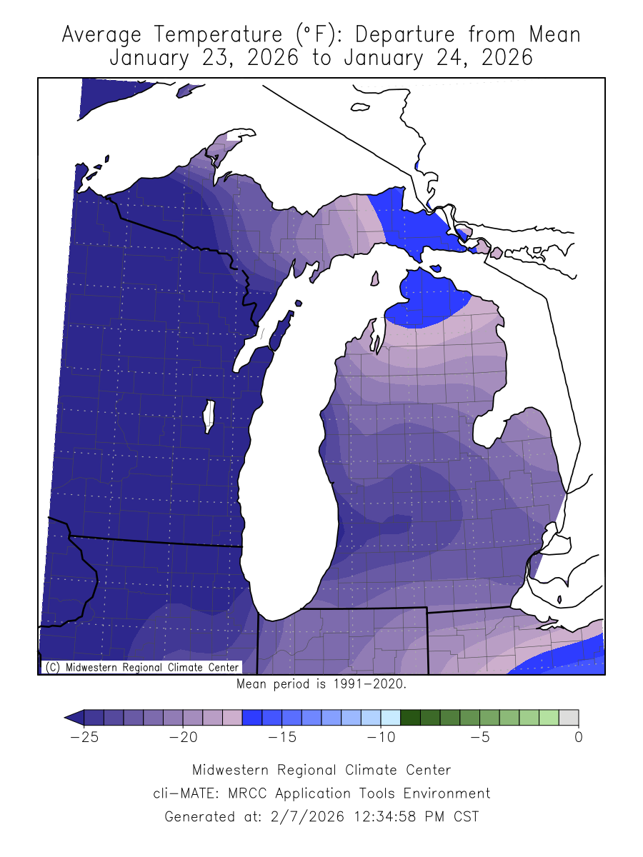
 |
Media use of NWS Web News Stories is encouraged! Please acknowledge the NWS as the source of any news information accessed from this site. |
|

