
Dry and windy conditions will bring widespread fire weather concerns to the northern/central Plains and portions of the Southwest into the southern Plains. Severe thunderstorms with large hail and damaging wind gusts are possible over the central Plains today into this weekend. Rain and high elevation snow is expected over parts of the Cascades and Northern Intermountain Region through Saturday. Read More >
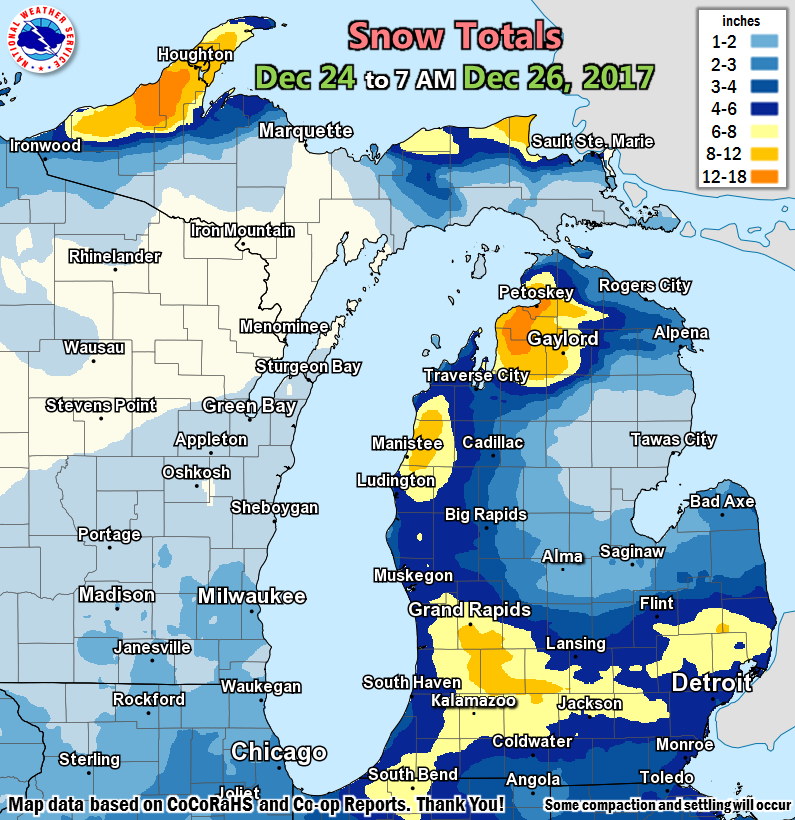
Public Information Statement
National Weather Service Grand Rapids MI
1029 AM EST Tue Dec 26 2017

...48 Hour Snowfall Reports from CoCoRaHS and Co-op Observers...

Location                     Amount    Time/Date       Lat/Lon

...Michigan...

...Allegan County...
Hopkins 1 N                  6.6 in    0700 AM 12/26   42.64N/85.76W

...Barry County...
Hastings                     7.5 in    0700 AM 12/26   42.65N/85.30W

...Clare County...
8 SW Skeels                  1.0 in    0800 AM 12/26   43.99N/84.70W

...Clinton County...
Capital City Airport         4.7 in    0653 AM 12/26   42.78N/84.59W

...Eaton County...
Grand Ledge                  4.2 in    0800 AM 12/26   42.76N/84.75W

...Gratiot County...
Saint Louis                  1.5 in    1159 PM 12/25   43.40N/84.61W

...Ingham County...
4 NNW Dansville              6.5 in    0800 AM 12/26   42.61N/84.34W

...Ionia County...
2 NE Saranac                 5.5 in    0630 AM 12/26   42.96N/85.17W

...Isabella County...
3 ESE Mount Pleasant         2.0 in    0700 AM 12/26   43.58N/84.71W
4 SSE Shepherd               1.8 in    0700 AM 12/26   43.47N/84.67W

...Jackson County...
2 NNE Topkins                7.4 in    0900 AM 12/26   42.41N/84.53W
1 N Grass Lake               6.8 in    0700 AM 12/26   42.27N/84.20W
1 WNW Vandercook Lake        5.9 in    0800 AM 12/26   42.21N/84.42W

...Kalamazoo County...
3 W Portage                  8.3 in    0800 AM 12/26   42.21N/85.66W
Western Michigan University  7.4 in    1159 PM 12/25   42.28N/85.61W

...Kent County...
East Grand Rapids            9.3 in    0700 AM 12/26   42.94N/85.61W
Nws Forecast Office Grand Ra 8.9 in    0700 AM 12/26   42.89N/85.54W
1 N East Grand Rapids        5.9 in    0700 AM 12/26   42.97N/85.61W
2 WNW Belmont                5.9 in    0700 AM 12/26   43.09N/85.64W

...Mason County...
6 NW Scottville              7.2 in    0500 AM 12/26   44.04N/86.34W
Scottville 2 SE              4.4 in    0700 AM 12/26   43.93N/86.25W

...Mecosta County...
Big Rapids Water Works       3.8 in    0700 AM 12/26   43.70N/85.48W
2 NW Sylvester               2.1 in    0700 AM 12/26   43.56N/85.28W

...Muskegon County...
Muskegon County Airport      5.2 in    0655 AM 12/26   43.17N/86.24W

...Newaygo County...
4 WSW Fremont                6.0 in    0700 AM 12/26   43.45N/86.03W
4 SE Woodville               4.1 in    0700 AM 12/26   43.61N/85.64W

...Ottawa County...
Holland                      5.0 in    0700 AM 12/26   42.80N/86.20W

...Van Buren County...
3 NNE Paw Paw                6.3 in    0700 AM 12/26   42.27N/85.86W

Observations are collected from a variety of sources with varying
equipment and exposures. We thank all volunteer weather observers
for their dedication. Not all data listed are considered official.
 |
Media use of NWS Web News Stories is encouraged! |
|

