Scattered thunderstorms with severe gusts, hail and a tornado risk are possible near a cold front from the Ohio Valley to the Mid-Atlantic tonight. Tropical Storm Bertha is expected to bring tropical storm conditions to portions of the Gulf Coast from the panhandle of Florida into Louisiana through Wednesday. Read More >
April 7, 2020: Severe Hail in Lower Michigan
|
|
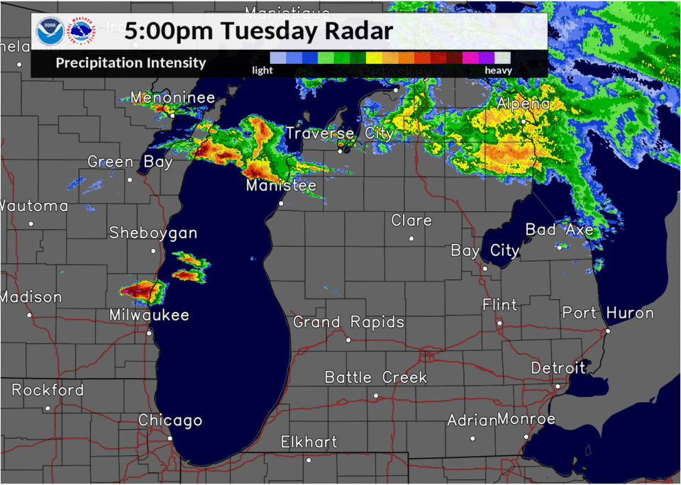
| Radar loop from 5 PM to 11 PM, 4/7/2020 |
A warm and relatively humid early spring day with sharply colder air aloft provided the instability needed for thunderstorms to develop late in the day, touched off by a wave of low pressure approaching from the west. Wind shear between the lower and upper layers of the atmosphere helped organize the storms into long-lived cells and lines. Many of the storms produced severe hail greater than 1 inch in diameter. Several locations in central to southwest Lower Michigan reported hail the size of golf balls. The Plainwell and Morley areas saw hail about the size of hen eggs, 2 inches in diameter.
 |
 |
|
2-inch diameter hail in Plainwell. Photo by Erik Kostrzewa, FOX 17. |
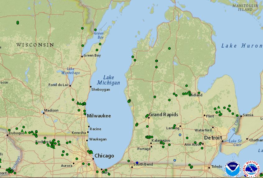
Green circles represent reports of hail 1-inch or larger, while blue circles indicate wind damage. (Click image to enlarge) (All reports) |
Preliminary Storm Reports
PRELIMINARY LOCAL STORM REPORT...SUMMARY
NATIONAL WEATHER SERVICE GRAND RAPIDS MI
1039 PM EDT TUE APR 7 2020

..TIME...   ...EVENT...      ...CITY LOCATION...     ...LAT.LON...
..DATE...   ....MAG....      ..COUNTY LOCATION..ST.. ...SOURCE....
            ..REMARKS..

0954 PM     HAIL             5 ENE PINE CREEK        42.19N 85.16W
04/07/2020  M1.00 INCH       CALHOUN            MI   PUBLIC


0950 PM     HAIL             1 SE MARSHALL           42.25N 84.94W
04/07/2020  M1.00 INCH       CALHOUN            MI   PUBLIC


0939 PM     HAIL             3 S BROWNLEE PARK       42.28N 85.14W
04/07/2020  M1.50 INCH       CALHOUN            MI   PUBLIC


0938 PM     HAIL             1 E SPRINGFIELD         42.32N 85.22W
04/07/2020  U1.00 INCH       CALHOUN            MI   PUBLIC

            REPORT FROM MPING: QUARTER (1.00 IN.).

0936 PM     HAIL             2 SSE SPRINGFIELD       42.30N 85.23W
04/07/2020  M1.00 INCH       CALHOUN            MI   PUBLIC


0928 PM     HAIL             2 S MOUNT PLEASANT      43.57N 84.77W
04/07/2020  M1.25 INCH       ISABELLA           MI   PUBLIC


0926 PM     HAIL             PLAINWELL               42.45N 85.64W
04/07/2020  M2.00 INCH       ALLEGAN            MI   BROADCAST MEDIA


0912 PM     HAIL             PLAINWELL               42.44N 85.65W
04/07/2020  U1.00 INCH       ALLEGAN            MI   PUBLIC

            REPORT FROM MPING: QUARTER (1.00 IN.).

0911 PM     HAIL             2 S OTSEGO              42.44N 85.70W
04/07/2020  U1.00 INCH       ALLEGAN            MI   PUBLIC

            REPORT FROM MPING: QUARTER (1.00 IN.).

0910 PM     HAIL             PLAINWELL               42.45N 85.64W
04/07/2020  M2.00 INCH       ALLEGAN            MI   BROADCAST MEDIA


0909 PM     HAIL             2 W VESTABURG           43.41N 84.94W
04/07/2020  U1.00 INCH       MONTCALM           MI   PUBLIC

            REPORT FROM MPING: QUARTER (1.00 IN.).

0900 PM     HAIL             OTSEGO                  42.46N 85.70W
04/07/2020  M1.75 INCH       ALLEGAN            MI   PUBLIC

            TIME ESTIMATED FROM RADAR.

0855 PM     HAIL             3 W OTSEGO              42.45N 85.75W
04/07/2020  M1.75 INCH       ALLEGAN            MI   TRAINED SPOTTER


0847 PM     HAIL             2 SW FITCHBURG          42.43N 84.31W
04/07/2020  U1.00 INCH       INGHAM             MI   PUBLIC

            REPORT FROM MPING: QUARTER (1.00 IN.).

0845 PM     HAIL             DORR                    42.73N 85.72W
04/07/2020  E1.00 INCH       ALLEGAN            MI   PUBLIC


0836 PM     HAIL             MORLEY                  43.49N 85.45W
04/07/2020  M1.75 INCH       MECOSTA            MI   PUBLIC

            TIME ESTIMATED FROM RADAR.

0827 PM     HAIL             1 SSE HOLLAND           42.76N 86.10W
04/07/2020  M1.00 INCH       ALLEGAN            MI   TRAINED SPOTTER


0826 PM     HAIL             2 SSW COMSTOCK PARK     43.02N 85.70W
04/07/2020  M1.00 INCH       KENT               MI   TRAINED SPOTTER


0825 PM     HAIL             2 NE HOLLAND            42.79N 86.08W
04/07/2020  M1.00 INCH       OTTAWA             MI   TRAINED SPOTTER


0820 PM     HAIL             GRAND LEDGE             42.75N 84.75W
04/07/2020  M1.75 INCH       EATON              MI   TRAINED SPOTTER


0800 PM     HAIL             4 SSW GRAND LEDGE       42.70N 84.78W
04/07/2020  M1.00 INCH       EATON              MI   TRAINED SPOTTER


0722 PM     HAIL             WALKER                  42.99N 85.75W
04/07/2020  E1.00 INCH       KENT               MI   PUBLIC


0630 PM     HAIL             2 SW WHITEHALL          43.37N 86.37W
04/07/2020  M1.50 INCH       MUSKEGON           MI   PUBLIC


0625 PM     HAIL             WHITEHALL               43.40N 86.34W
04/07/2020  M1.00 INCH       MUSKEGON           MI   PUBLIC


0625 PM     HAIL             1 SSW WHITEHALL         43.38N 86.35W
04/07/2020  M1.75 INCH       MUSKEGON           MI   PUBLIC

            CORRECTS PREVIOUS HAIL REPORT FROM 1 SSW
            WHITEHALL. TIME ESTIMATED FROM RADAR.

0903 PM     TSTM WND DMG     2 WSW AURELIUS          42.51N 84.56W
04/07/2020                   INGHAM             MI   PUBLIC

            TREE DOWN ACROSS PLAINS ROAD.
0847 PM     HAIL             SIX LAKES               43.43N 85.15W
04/07/2020  E1.75 INCH       MONTCALM           MI   AMATEUR RADIO

            DELAYED REPORT. PHOTOS OF GOLF BALL SIZE
            HAIL. POSSIBLY HEN EGG SIZE.

0840 PM     HAIL             1 E ALTONA              43.54N 85.28W
04/07/2020  E1.75 INCH       MECOSTA            MI   AMATEUR RADIO

            DELAYED REPORT. PHOTOS OF GOLF BALL SIZE
            HAIL. POSSIBLY HEN EGG SIZE.
0728 PM     HAIL             LAKE                    43.86N 85.00W
04/07/2020  E1.75 INCH       CLARE              MI   PUBLIC

            DELAYED REPORT. PHOTO OF LARGE HAIL.
0849 PM     HAIL             2 NW ALLEGAN            42.55N 85.88W
04/07/2020  E1.00 INCH       ALLEGAN            MI   PUBLIC

            DELAYED REPORT.
0922 PM     HAIL             1 W EASTWOOD            42.30N 85.57W
04/07/2020  U0.75 INCH       KALAMAZOO          MI   PUBLIC

            DELAYED REPORT. FROM MPING.

0918 PM     HAIL             2 SW WESTWOOD           42.28N 85.66W
04/07/2020  U0.75 INCH       KALAMAZOO          MI   PUBLIC

            DELAYED REPORT. FROM MPING.
0917 PM     HAIL             2 WSW WESTWOOD          42.30N 85.67W
04/07/2020  M1.00 INCH       KALAMAZOO          MI   PUBLIC

            DELAYED REPORT. TWO PHOTOS FROM OSHTEMO TWP
            VIA SOCIAL MEDIA.
0925 PM     HAIL             2 N GALESBURG           42.32N 85.42W
04/07/2020  M2.00 INCH       KALAMAZOO          MI   PUBLIC

            DELAYED REPORT. PHOTO VIA SOCIAL MEDIA.
|
 |
Media use of NWS Web News Stories is encouraged! Please acknowledge the NWS as the source of any news information accessed from this site. |
|