New Orleans/Baton Rouge
Weather Forecast Office
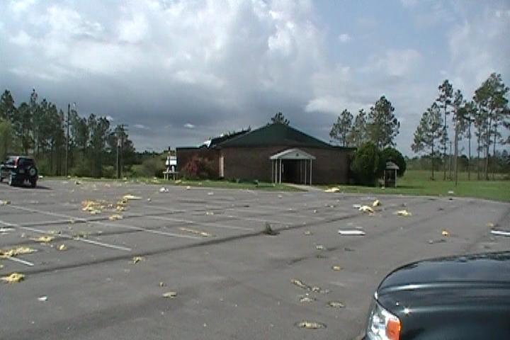
Northern Hancock County Tornado - March 27, 2009
|
Rating:
|
EF-1
|
|
Estimated Maximum Wind:
|
100 mph
|
|
Injuries/Fatalities:
|
None
|
|
Damage Path Length:
|
7.7 miles
|
|
Maximum Path Width:
|
200 yards
|
|
Approximate Start Point/Time:
|
8 miles SW of Necaise, MS at 140 AM
|
|
Approximate End Point/Time:
|
2 miles S of Necaise, MS at 146 AM
|
|
A National Weather Service Damage Assessment Team has surveyed the storm damage in Northern Hancock County. It has been determined the damage was the result of a tornado. The tornado has been rated an EF-1 on the Enhanced Fujita Scale. Damage estimates were consistent with winds of approximately 100 mph. The tornado touched down near the intersection of MS State Hwy 43 and Leetown Road. This location is approximately 8 miles southwest of Necaise, MS. The tornado tracked northeastward for about 8 miles. The most significant damage occurred as the tornado moved along St. Matthew Church Road and then crossed MS State Hwy 603. A church building has a portion of the roof removed and a large outbuilding was destroyed. The tornado damage path was 7.7 miles long and was 200 yards wide at its widest point. No injuries or fatalities were reported. |
|
|
||||||||||||||
Current Hazards
Extended Outlooks
Outlooks
Fire Manager Quick Brief
Briefing Page
Storm Prediction Center
Forecasts
Marine Forecast
Activity Planner
River Forecasts
Tropical Forecast
Forecast Discussion
Aviation Weather Forecast
Graphical Forecast
Weather Models and Maps
Fire Weather Forecast
Hourly Weather Graph
Air Quality Forecasts
US Dept of Commerce
National Oceanic and Atmospheric Administration
National Weather Service
New Orleans/Baton Rouge
62300 Airport Rd.
Slidell, LA 70460-5243
504.522.7330 985.649.0429
Comments? Questions? Please Contact Us.