New Orleans/Baton Rouge
Weather Forecast Office
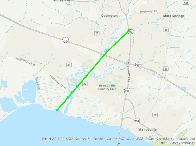
Madisonville, LA to Covington, LA Tornado - March 15, 2025
|
Rating:
|
EF-1
|
|
Estimated Maximum Wind:
|
95 mph
|
|
Injuries/Fatalities:
|
None
|
|
Damage Path Length:
|
7.55 miles
|
|
Maximum Path Width:
|
20 yards
|
|
Approximate Start Point/Time:
|
1 mile SSW of Madisonville, LA at 417 PM CDT
|
|
Approximate End Point/Time:
|
2 miles ESE of Covington,LA at 428 PM CDT
|
|
A National Weather Service Damage Assessment Team has surveyed the storm damage between Madisonville, LA and Covington, LA. It has been determined the damage was the result of a tornado. The tornado has been rated an EF-1 on the Enhanced Fujita Scale. Damage estimates were consistent with winds of 95 mph. A waterspout moved onshore near Madisonville causing damage to marsh grass south of Hwy 22 which is visible in high resolution satellite data. The first damage point observed on the in-person survey was on LA Hwy 22 where several branches were snapped just west of Fairview-Riverside State Park. The tornado moved northeastward through the Deloaks neighborhood causing numerous small to medium branches to fall from trees and downing one tree on Elmwood Loop. As the tornado continued northeastward it caused additional damage to trees, with several trees downed along Three Rivers Rd. The tornado appears to have lifted as it approached Hwy 190, but not before downing a large pine tree on Maple Ridge Way. |
|
|
Current Hazards
Outlooks
Fire Manager Quick Brief
Briefing Page
Storm Prediction Center
Extended Outlooks
Forecasts
Activity Planner
River Forecasts
Tropical Forecast
Forecast Discussion
Aviation Weather Forecast
Graphical Forecast
Weather Models and Maps
Fire Weather Forecast
Hourly Weather Graph
Air Quality Forecasts
Marine Forecast
US Dept of Commerce
National Oceanic and Atmospheric Administration
National Weather Service
New Orleans/Baton Rouge
62300 Airport Rd.
Slidell, LA 70460-5243
504.522.7330 985.649.0429
Comments? Questions? Please Contact Us.